…a cidade de Fairbanks tinha ficado para trás pelo retrovisor!. Íamos rumo ao sul, agora pela “Parks Highway” (estrada #3), com bom tempo, atravessando algumas pontes sobre rios ou riachos, apreciando um cenário de alguma montanha com longas retas e curvas suaves até ao “Denali National Park and Preserve”!.
…the city of Fairbanks had been behind the rearview mirror!. We were going to the south, now for “Parks Highway” (road #3), with a good time, crossing some bridges on rivers or streams, enjoying a scenario of some mountain with long straight and soft curves to the “Denali National Park and Preserve”!.
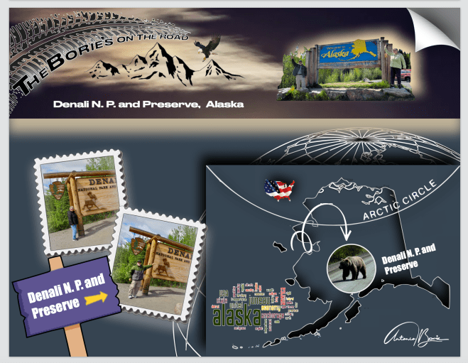
…aqui, já em expedições anteriores tínhamos conduzido a nossa “White Fox” (caravana) até onde era autorizado no Parque Denali!. Isto era uma coisa, no entanto viajar para dentro do parque, era outra!. Porquê?. Porque a estrada que nos leva ao Parque Denali é uma das estradas mais bonitas onde provavelmente já viajamos!. Ela mergulha em algumas milhas na natureza selvagem do Alaska e…, ao conseguirmos chegar cada vez mais perto do Grande Denali, ou Monte McKinley,se preferirem, a montanha mais alta dos USA, é quase certo que vamos ter alguns encontros inesquecíveis com a vida selvagem ao longo deste caminho!.
…here, in previous expeditions we had led our “White Fox” (caravan), as far as it was authorized in Denali Park!. This was one thing, however, traveling into the park, it was another!. Why?. Why the road that takes us to Denali Park is one of the most beautiful roads where we probably already travel!. She plunges into a few miles in the wild of Alaska and…, as we get closer and closer to Greater Denali, or Monte McKinley, if you prefer, the highest mountain of the USA, it is almost certain that we will have some unforgettable meetings with life Wild along this path!.
…então porque razão não o podemos fazer na nossa “White Fox” (caravana)?. Simplesmente porque não nos é permitido!. Após as primeiras 18 ou 20 milhas, a circulação de veículos particulares é restrita!. Para além do Savage River, ou seja, para lá da pequena ponte que o atravessa, aproximadamente na milha 15 ou 16, a estrada é de terra e cascalho, e apenas camionetas aprovadas pelo parque são permitidas!.
…so why can’t we do it in our “White Fox” (caravan)?. Simply because it is not allowed!. After the first 18 or 20 miles, the circulation of private vehicles is restricted!. In addition to the Savage River, that is, beyond the small bridge that crosses it, approximately in mile 15 or 16, the road is of land and gravel, and only van approved by the park are allowed!.
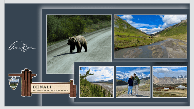
…como tal, vindos do norte e chegamos ao Centro de Visitas do Parque e prontos para o explorar, informaram-nos que para isso era necessário pagar pela viajem, que seria feita em camionetas do parque!. Apesar de na nossa já um pouco avançada idade todos os centavos contam, no entanto, comprámos os bilhetes com todos aqueles descontos permitidos pela idade e…, lá fomos pela estrada que começa ganhando alguma elevação depois de deixar o Centro de Visitas, mergulhando instantaneamente nas profundezas da natureza!.
…as such, coming from the north and we arrived at the Park Visit Center and ready to explore it, informed us that it was necessary to pay for the trip, which would be made in park!. Although in our already a little advanced age all cents count, however, we bought the tickets with all those discounts allowed by age and…, we went through the road that starts gaining some elevation after leaving the center of visits, diving instantly in depths of nature!.
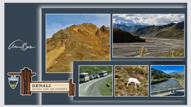
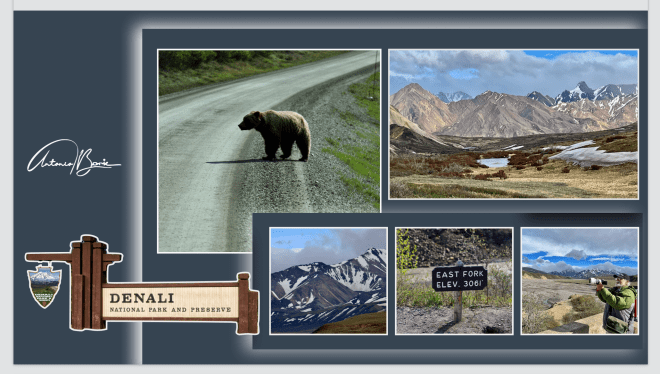
…e era verdade!. Durante as quase cinco horas de viajem, percorremos parte dos mais de seis milhões de acres de terras selvagens, da montanha mais alta da América do Norte, com cerca de 20.310 pés, cortada ao meio apenas por uma única estrada de terra e cascalho, com mais de 100 milhas de extensão!. Parando aqui e ali, com explicações do condutor/guia, umas vezes dando prioridade aos animais para atravessar a estrada outras atravessando áreas de precipícios ou cruzando pequenos riachos, percorremos vales, montanhas grandes com neve, outras mais pequenas com lindos cenários e ovelhas Dali pastando!. Vimos ursos pardos e negros, lobos, caribus e alces, bem como águias douradas e carecas, e muitas outras formas de vida selvagem, incluindo as já mencionadas ovelhas Dali!. Valeu a pena!.
…and it was true!. During the nearly five hours of travel, we traveled part of the more than six million in the savage lands, from the highest mountain in North America, with about 20,310 feet, cut in half by a single dirt and gravel road, with More than 100 miles of extension!. Stopping here and there, with explanations of the driver/guide, sometimes giving priority to the animals to cross the road other crossing areas or crossing small streams, we travel valleys, large mountains with snow, others smaller with beautiful scenarios and sheep grazing ! We saw brown and black bears, wolves, caribus and alces, as well as gold eagles and bald eagles, and many other wildlife forms, including the aforementioned sheep there!. It was worth it!.
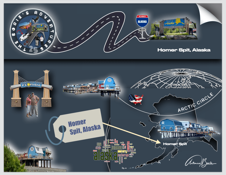
…foi a quarta vez que visitámos “Homer Spit” porque para nós continua a ser um dos nossos lugares preferidos!. Por aqui ficamos alguns dias, dizendo sempre…, que na próxima oportunidade cá estaremos de novo, porque encontramos um maravilhoso cenário de docas com águas profundas ou rasas e as cores das mais 1.500 embarcações comerciais e de lazer!.
…it was the fourth time we visited “Homer Spit” because for us it continues to be one of our favorite places!. We stayed here for a few days, always saying… that next time we will be here again, because we found a wonderful scenery of docks with deep or shallow waters and the colors of over 1,500 commercial and leisure vessels!.
…”Homer Spit” é um fenómeno geográfico muito estranho!. O terreno circundante do continente é acidentado, mas a ponta em si não é muito mais do que um banco de areia, embora seja um banco de areia incrível que se estende por quase sete quilómetros até a Baía de Kachemak!. Ninguém sabe exatamente como se formou, seja por correntes de maré complexas ou pelo recuo de antigas geleiras!.
…”Homer Spit” is a very strange geographical phenomenon!. The terrain surrounding the mainland is rugged, but the point itself isn’t much more than a sandbar, although it is an incredible sandbar that stretches nearly seven kilometers into Kachemak Bay!. No one knows exactly how it was formed, whether by complex tidal currents or the retreat of ancient glaciers!.
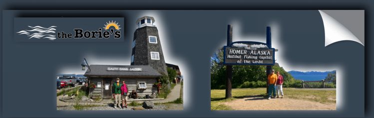
…existem outras atracções adicionais, como por exemplo, o “The Nick Dudiak Fishing Lagoon”, que é um “buraco de pesca” artificial, acampamentos, hotéis e restaurantes!. O “Salty Dawg Saloon”, é provavelmente o marco mais notável de “Homer Spit” porque o seu exterior peculiar, (um farol de madeira combinado com um galpão rústico), faz com que se destaque, mas o verdadeiro charme está no interior onde a atmosfera é verdadeiramente única, é mal iluminada, sempre movimentada, e cada centímetro das paredes e do teto está coberto de notas de dólar deixadas por visitantes de todo o mundo!.
…there are other additional attractions, such as “The Nick Dudiak Fishing Lagoon”, which is an artificial “fishing hole”, campsites, hotels and restaurants!. The “Salty Dawg Saloon”, is probably “Homer Spit’s” most notable landmark because its quirky exterior, (a wooden lighthouse combined with a rustic shed), makes it stand out, but the real charm is inside where the atmosphere is truly It’s unique, it’s dimly lit, always busy, and every inch of the walls and ceiling is covered in dollar bills left by visitors from all over the world!.
…no pequeno e único parque de RV onde pernoitámos na milha 804, na localidade de Teslin, onde os seus habitantes têm orgulho em dizer que é o lar da primeira nação “Teslin Inland Tlingit First”, uma senhora oriunda do estado de Illinois, que estacionou ao nosso lado não se cansava de nos dizer “vou para o Alaska onde trabalho todos os anos nos meses de Junho, Julho, Agosto e Setembro, depois regresso a Illinois, à minha terra natal”!.
…in the small and unique RV park where we spent the night at mile 804, in the town of Teslin, where its inhabitants are proud to say that it is home to the “Teslin Inland Tlingit First” nation, a lady from the state of Illinois, who He parked next to us and never tired of telling us “I’m going to Alaska where I work every year in the months of June, July, August and September, then I’m going back to Illinois, to my homeland”!.
…e continuava, “não é só pelo trabalho que ajuda a minha sobrevivência, que para aqui venho, é também pela aventura de viajar pelo “Histórico Alaska Highway” pois é um “zoológico gratuito”, ou mais precisamente…, um safari não guiado, porque os animais estão sempre lá!. São os ursos pretos ou pardos, os alces, os bisontes, as raposas, as ovelhas da montanha, os búfalos, as águias, os veados, os lobos da floresta, as pegas, os castores, os linces, e a lista podia continuar…, que constantemente atravessavam a estrada ou se alimentavam ao redor”!.
…and continued, “it is not only for the work that helps my survival, that I come here, it is also for the adventure of traveling the “Historic Alaska Highway” as it is a “free zoo”, or more precisely…, an unguided safari , because the animals are always there! They constantly crossed the road or fed around it”!.
…era verdade!. Vamos então continuar!.
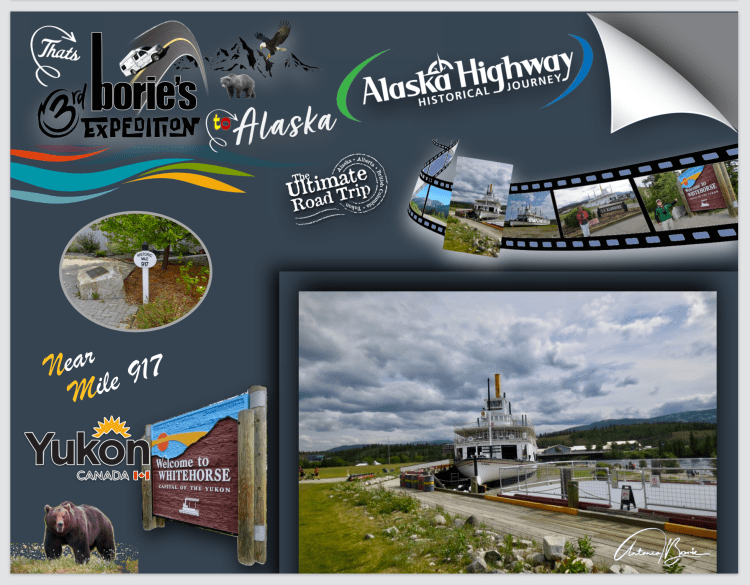
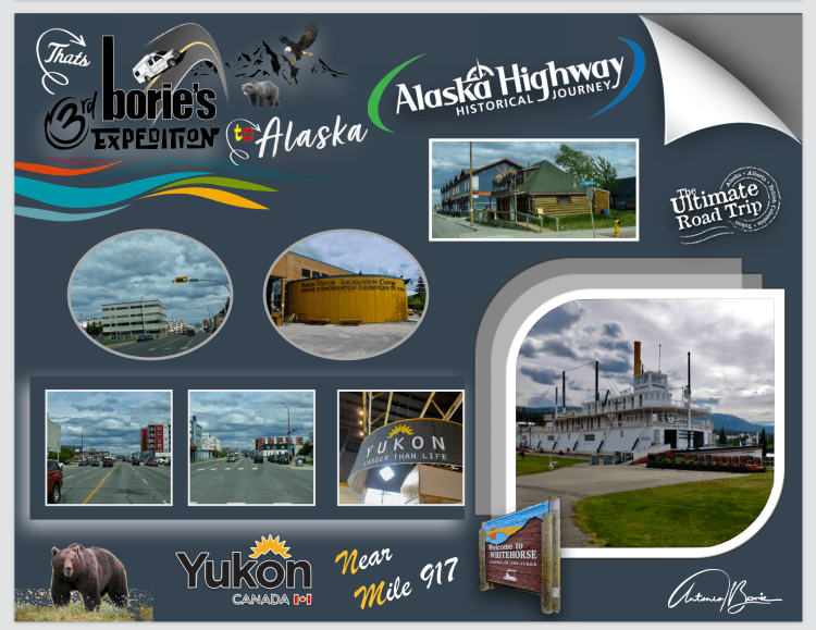
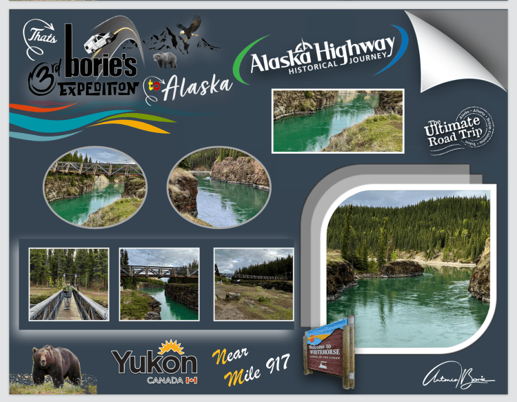
…Milha 918– cidade de Whitehorse!. O viajante do “Histórico Alaska Highway”, quando chega à cidade de Whitehorse, pára o seu veículo, abre os braços e diz que, “finalmente chegou à civilização”!. A cidade tem o que normalmente se necessita para a sobrevivência, além de um Centro de Visitas muito funcional, prestando informação com eficiência e, tem sinal de internet!. Nós deambulámos pela cidade e visitámos um barco que nos faz lembrar os primeiros pesquisadores de ouro que apareceram na região nas suas aventuras pelo Rio Yukon!.
…it was true! So let’s continue!
…Mile 918 – city of Whitehorse!. The traveler on the “Historic Alaska Highway”, when he arrives in the city of Whitehorse, in his vehicle, opens his arms and says that, “he has finally arrived at civilization”!. The city has what is normally needed for survival, in addition to a very functional Visitor Center, providing information efficiently and has an internet signal! We wandered around town and visited a boat that reminds us of the first gold searchers who appeared in the region on their adventures along the Yukon River!.
…milha 918 – é uma paisagem antiga a poucos minutos do centro da cidade, que criou um dos locais mais bonitos de Whitehorse!. Quase nove milhões de anos atrás, uma torrente de lava basáltica espalhou-se por uma paisagem pré-glacial criando uma faixa de água azul-turquesa que corre entre as falésias que ainda restam!. As Primeiras Nações usavam este local como acampamento de pesca referindo-se à área como Kwanlin, que significa “água corrente pelo desfiladeiro” e que hoje dá pelo nome de “Canyon City”!. Os garimpeiros da Corrida do Ouro, chamavam de “Grand Canyon” e o usavam como via principal quando viajavam para o norte durante a Corrida do Ouro!. Naquela época, o tráfego pelos rios era tão intenso que a Polícia Montada do Noroeste estabeleceu aqui um posto avançado para verificar os barcos e garantir a segurança de sua viagem!.
…mile 918 – is an ancient landscape just minutes from the city center, which has created one of the most beautiful spots in Whitehorse!. Almost nine million years ago, a torrent of basaltic lava spread across a pre-glacial landscape creating a ribbon of turquoise water that runs between the remaining cliffs!. The First Nations used this location as a fishing camp, referring to the area as Kwanlin, which means “flowing water through the canyon” and which today goes by the name “Canyon City”!. Gold Rush miners called it “Grand Canyon” and used it as a main thoroughfare when traveling north during the Gold Rush!. their trip!. At that time, traffic on the rivers was so intense that the North West Mounted Police established an outpost here to check boats and ensure the safety of their journey!.
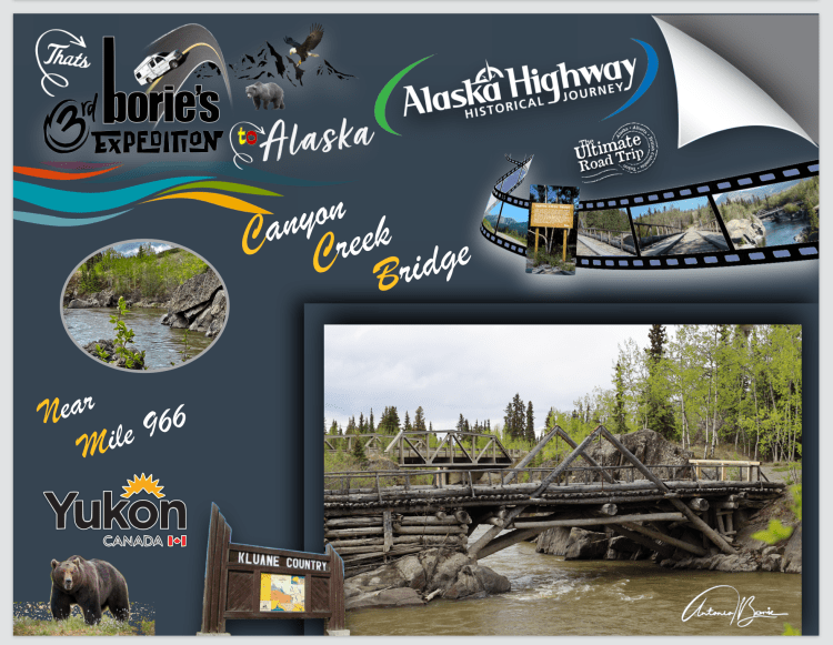
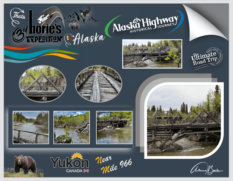
…milha 966 – “Historic Canyon Creek Bridge”!. É uma área de descanso onde estão painéis interpretativos sobre a história desta ponte, que também é um local excelente para tirar fotos!. A história diz que, uma corrida ao ouro no Rio Alsek, trouxe uma debandada de mineiros para esta área, onde imediatamente foi construída uma estrada para carroças a partir da cidade de Whitehorse!. De seguida, construíram uma ponte com a madeira das árvores que por ali havia, sobre um riacho que passava naquele desfiladeiro!.
…mile 966 – “Historic Canyon Creek Bridge”!. It is a rest area where there are interpretive panels about the history of this bridge, which is also an excellent place to take photos! The story goes that a gold rush on the Alsek River brought a stampede of miners to this area, where a wagon road was immediately built from the city of Whitehorse! Then, they built a bridge with wood from the trees that were there, over a stream that passed through that gorge!.
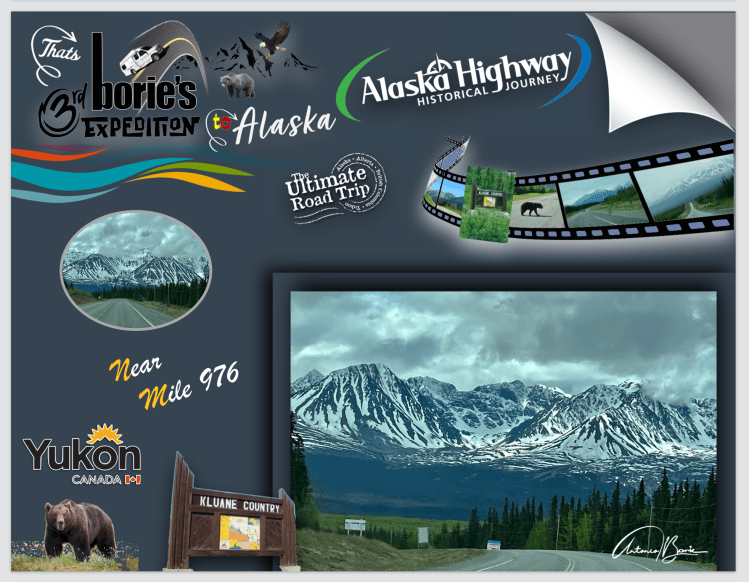
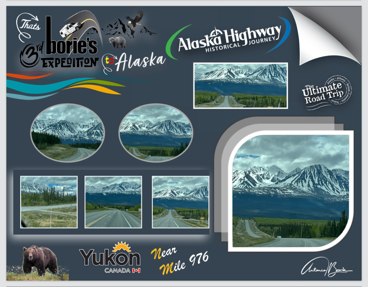
…milha 976 -Cordilheiras de gelo de Kluane!. Viajando na estrada, podemos observar uma vista impressionante das cordilheiras de gelo nas montanhas e em algumas povoações que vistas de perto nos pareciam abandonadas, assim como algumas aberturas na floresta que nos pareciam pequenos aeroportos, aparecendo aqui e ali ursos, tanto pretos como castanhos, que teimavam em ocupar a estrada!.
…mile 976 -Kluane Ice Ranges!. Traveling on the road, we can observe an impressive view of the ice ridges in the mountains and some villages that seemed abandoned up close, as well as some openings in the forest that looked like small airports, with bears appearing here and there, both black and brown, who insisted on occupying the road!.
…milha 985 – Haines Junction!. É uma povoação de cruzamento de estradas!. Tem quase todas as facilidades que um viajante de estrada necessita, incluindo sinalização, indicando diversas rotas a seguir!. Indo em direcção ao norte do estado do Alaska mudamos de direção!. Um pouco para norte, as montanhas em redor ainda têm neve, a sua história diz que, por cerca de dois mil anos, as pessoas do sul da Tutchone tiveram campos de caça e, caça sazonais na área da actual Haines Junction!.
…mile 985 – Haines Junction!. It’s a crossroads village! It has almost all the facilities a road traveler needs, including signage, indicating different routes to follow!. Heading towards the north of the state of Alaska, we changed direction! A little to the north, the surrounding mountains still have snow, their story says that, for about two thousand years, the people of southern Tutchone had hunting grounds and seasonal hunts in the area of present-day Haines Junction!.
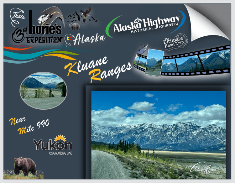
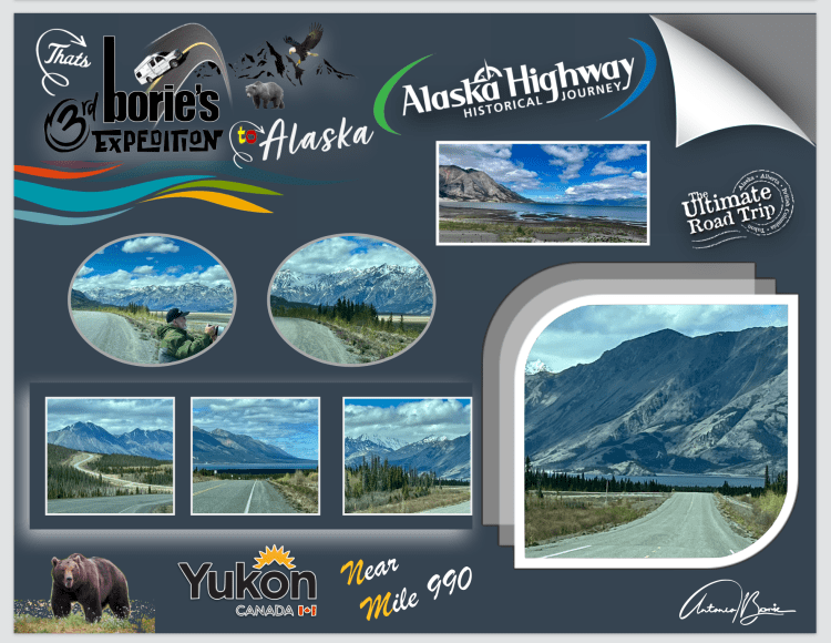
…milha 990 (aproximadamente) – “Kluane Ranges”!. Vista maravilhosa a sudoeste da Cordilheira Kluane, coberta de neve com a “Histórica Estrada do Alaska” a seguir paralela à Cordilheira desde a povoação de Haines Junction, apresentando uma corrente quase ininterrupta de montanhas com 8.000 pés de altura, interrompida por apenas alguns grandes vales, cortados pelos “glaciers”!.
…mile 990 (approximately) – “Kluane Ranges”!. Wonderful view southwest of the snow-capped Kluane Range with the “Historic Alaska Highway” running parallel to the Haines Junction Settlement Range, featuring an almost unbroken chain of 8,000-foot high mountains, interrupted by only a few large valleys, cut by “glaciers”!.
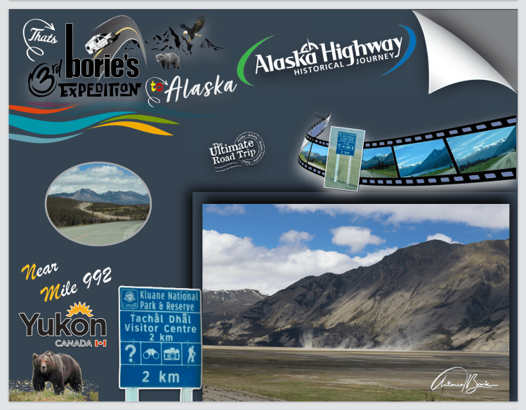
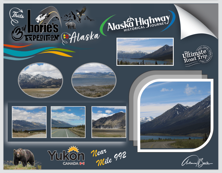
…milha 992 (aproximadamente) – “Parque Nacional de Kluane”!. É uma reserva, no Território de Yukon para os amantes do ar livre, que podem apreciar as maravilhas deste parque!. A sua beleza selvagem é impressionante fazendo com que o Parque Nacional e Reserva de Kluane, fosse declarado Património da Humanidade pela UNESCO, no ano de 1979!. Abriga 17 dos 20 picos mais altos de todo o Canadá, sendo o maior campo de gelo alpino não polar do mundo!.
…mile 992 (approximately) – “Kluane National Park”!. It is a reserve in the Yukon Territory for outdoor lovers, who can enjoy the wonders of this park!. Its wild beauty is impressive, causing the Kluane National Park and Reserve to be declared a World Heritage Site by UNESCO in 1979!. It is home to 17 of the 20 highest peaks in all of Canada, making it the largest non-polar alpine ice field in the world!.
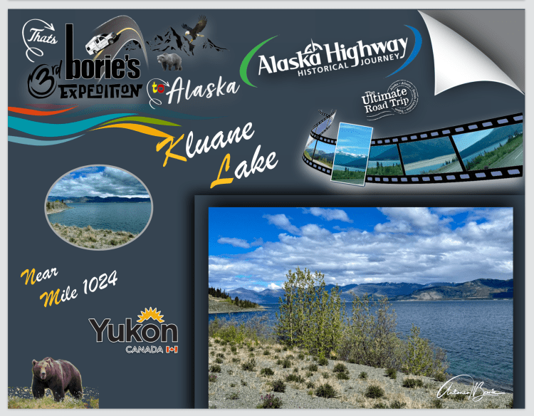
…milha 1024 (aproximadamente) – Lago Kluane!. A estrada segue a maior parte da fronteira sul do Lago Kluane, oferecendo lindas vistas do lago!. É o maior lago contido inteiramente dentro do Território do Yukon, com aproximadamente 50 milhas de comprimento!. Até ao ano de 2016, foi alimentado pelo A’ay Chu (rio Slims) que era composto por água do degelo do Glaciar Kaskawulsh, localizado dentro do Parque Nacional de Kluane!. Drena para o rio Kluane, cujas águas correm para o rio Donjek, o rio White, o rio Yukon e, por fim, o mar de Bering!.
…mile 1024 (approximately) – Kluane Lake!. The road follows most of the southern border of Lake Kluane, offering beautiful views of the lake!. It is the largest lake contained entirely within the Yukon Territory, approximately 50 miles long!. Until 2016, it was fed by the A’ay Chu (Slims River) which was composed of meltwater from the Kaskawulsh Glacier, located within Kluane National Park!. It drains into the Kluane River, whose waters flow into the Donjek River, the White River, the Yukon River and finally the Bering Sea!.
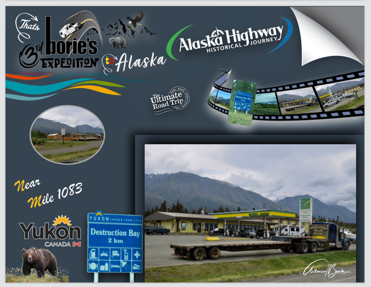
…milha 1050 – continuando a nossa jornada rumo ao norte/oeste, fomos cruzando algumas povoações, umas com pequenas lojas com gasolina ou outros artigos de sobrevivência para viajantes, outras única e simplesmente abandonadas!. Entretanto chegámos à povoacão de Destruction Bay!. É uma povoação que por certo nasceu e cresceu ao lado da hoje famosa e “Histórica Alaska Highway” e do Lago Kluane!. É muito popular nos viajantes desta famosa estrada, pois tem onde dormir, fazer refeições e reparação de veículos!.
…mile 1050 – continuing our journey towards the north/west, we crossed some villages, some with little shops with gasoline or other survival items for travelers, others simply abandoned!. Meanwhile we arrived at the town of Destruction Bay!. It is a town that was certainly born and raised next to the now famous “Historic Alaska Highway” and Kluane Lake!. It is very popular with travelers on this famous road, as it has places to sleep, eat meals and have vehicle repairs!
…milha 1061 – povoação de Burwash Landing!. O local actual de Burwash Landing, foi usado pela primeira vez como um acampamento de verão pelos Southern Tutchone Athabascans, até que um posto de comércio foi construído no início dos anos 1900, pelos irmãos Jacquot. É o lar do Museu Kluane de História Natural e da primeira Nação Kluane e também o lar do maior prato de pesquizar ouro do mundo!.
…mile 1061 – Burwash Landing settlement!. The current site of Burwash Landing, was first used as a summer camp by the Southern Tutchone Athabascans, until a trading post was built in the early 1900s by the Jacquot brothers. It is home to the Kluane Museum of Natural History and the first Kluane Nation and also home to the largest gold pan in the world!.
…milha 1167 – povoação de Beaver Creek!. É uma povoação fronteiriça, que se situa próximo da passagem fronteiriça de Alcan-Beaver Creek!. É a comunidade mais ocidental do Canadá e os principais empregadores são a Agência dos Serviços da Fronteira do Canadá!. Uma curiosidade, a Estação da Agência de Serviços da Fronteira do Canadá, é a mais distante do cruzamento de fronteira de qualquer estação aduaneira canadense, a uma distância de 17,8 milhas e, pelo menos até a década de 1990, alguns indivíduos viviam na “terra de ninguém” entre a fronteira e a estação de alfândega!.
…mile 1167 – Beaver Creek settlement!. It is a frontier village, which is located near the Alcan-Beaver Creek border crossing!. It is the westernmost community in Canada and the main employers are the Canadian Border Services Agency!. Interestingly, the Canada Border Services Agency Station is the furthest from the border crossing of any Canadian customs station, at a distance of 17.8 miles, and at least until the 1990s, some individuals lived at the border crossing. “no man’s land” between the border and the customs station!.
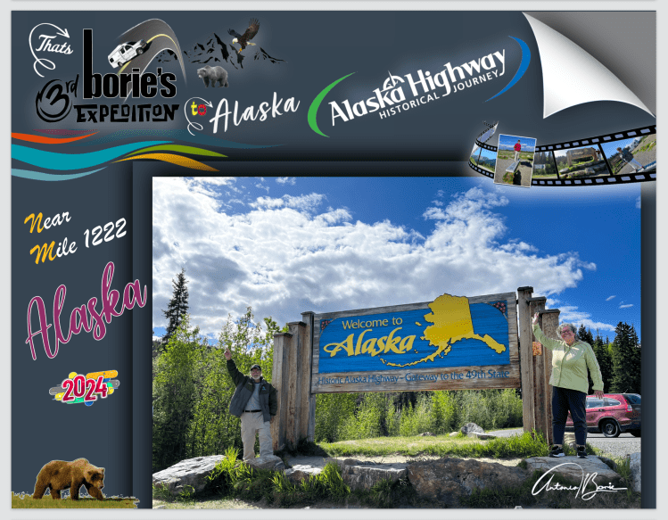
…milha 1186 – Bem-vindo ao Alaska, Canada/USA Internacional Fronteira!. É uma paragem que, não sendo obrigatória, nos merece uma visita, onde se pode admirar os marcos de fronteira, placas indicando a entrada no estado do Alaska, assim como alguma informação e história de ambos os países amigos, e claro, para tirar fotografias!. A Estação de Alfândega e Proteção de Fronteiras dos EUA será encontrada umas milhas mais à frente, mais propriamente na milha 1222 e, marca oficialmente sua entrada em solo americano!.
…mile 1186 – Welcome to Alaska, Canada / US International Border!. It is a stop that, although not mandatory, is worth a visit, where you can admire the border markers, signs indicating entry into the state of Alaska, as well as some information and history of both friendly countries, and of course, to take photographs !. The US Customs and Border Protection Station will be found a few miles further on, more precisely at mile 1222 and officially marks your entry into American soil!.
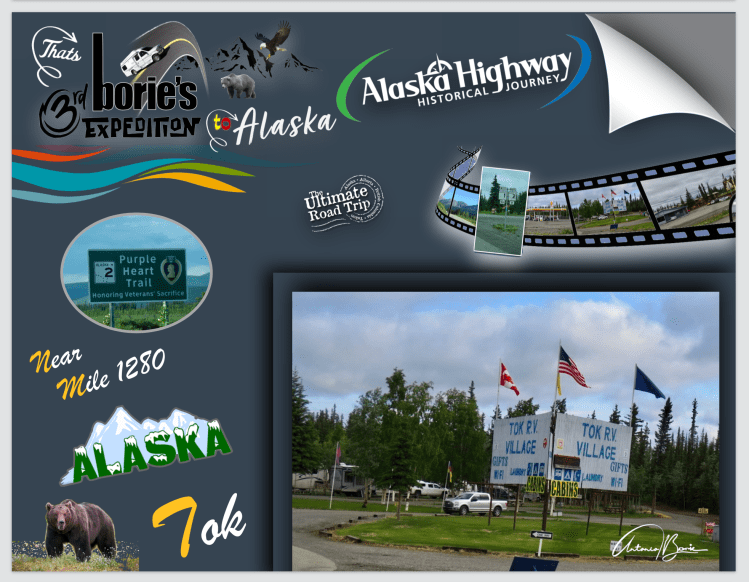
…até à milha 1280 – A estrada em algumas áreas está em melhor estado de conservação ou em reparação, a velocidade é controlada em milhas, existem algumas localidades onde se vende entre outras coisas gasolina medida em galões a um preço mais em conta!. Também podemos parar no Refúgio Nacional da Vida Selvagem da localidade Tetlin, onde os apreciadores de aves se deliciam com a paisagem dinâmica deste já mencionado Refúgio!.
…up to mile 1280 – The road in some areas is in better condition or undergoing repairs, speed is controlled in miles, there are some locations where gasoline measured in gallons is sold, among other things, at a more affordable price! . We can also stop at the Tetlin National Wildlife Refuge, where bird lovers will delight in the dynamic landscape of this aforementioned refuge!.
…milha 1280 – Cidade de Tok, já no Alaska!. Tok é o lar das boas-vindas não oficial do Alaska!, apelidada de “Capital do Cão de Trenó do Alaska”, ficando perto da fronteira com o Canadá!. Há muito tempo é considerada um paraíso para os viajantes desde a sua fundação em 1942, claro, graças à construção da hoje “Histórica Estrada do Alaska!. O centro de visitantes, assim como restaurantes e parques de RV, são fáceis de encontrar!. Aqui, podemos dizer que, “já chegámos ao Alaska”!. Portanto, vamos andar por aí, e que mais vamos ver?.
…mile 1280 – Town of Tok, now in Alaska!. Tok is home to the unofficial Alaskan Welcome!, nicknamed the “Sled Dog Capital of Alaska”, being close to the Canadian border!. It has long been considered a paradise for travelers since its founding in 1942, thanks of course to the construction of today’s “Historic Alaska Highway!” The visitor center, as well as restaurants and RV parks, are easy to find! Here, we can say that, “we have already arrived in Alaska”! So let’s walk around, and what else will we see?
…já chegámos ao Território do Yukon!. Hoje foi um dia de estrada!. Era sempre aos zig-zags subidas e descidas com vistas de rios, ribeiros, lagos e montanhas, muitos animais selvagens, principalmente ursos negros!. Contámos mais de duas dezenas!. É o “Histórico Alaska Highway” que adoramos!. Gasolina?. Sim, havia em muitos lugares, não como no passado em que levávamos depósitos extras!.
…we’ve already reached Yukon Territory!.Today was a day on the road!. It was always zig-zagging ups and downs with views of rivers, streams, lakes and mountains, lots of wild animals, especially black bears!. We counted more than two dozen! It’s the “Historic Alaska Highway” that we love! Gasoline?. Yes, there were in many places, not like in the past when we took extra deposits!.
…viajar pelo hoje lendário e “Histórico Alaska Highway” não é muito complicado, pelo menos para nós, veteranos!. Porquê?. Porque é só uma estrada, e para tornar ainda menos complicado, fomos contando as milhas no contador da nossa “White Fox’ (caravana)!. Assim, sabemos onde estamos quantas milhas já fizemos e quantas nos faltam para chegar ao nosso destino…, que é o Alaska!.
…traveling the legendary and “Historic Alaska Highway” is not very complicated, at least for us veterans!. Why?. Because it’s just a road, and to make it even less complicated, we counted the miles on the meter of our “White Fox” (caravan)!. This way, we know where we are, how many miles we have already covered and how many miles we have left to reach our destination…, which is Alaska!.
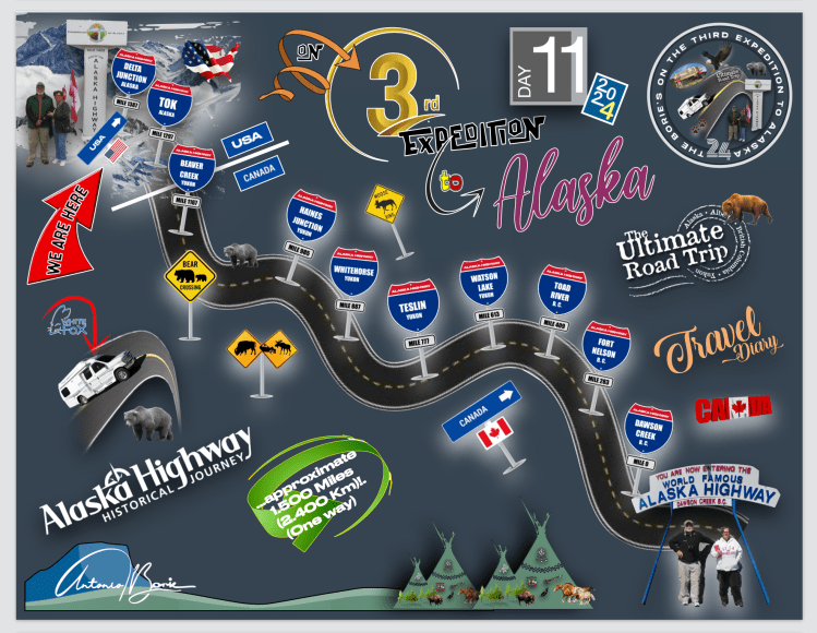
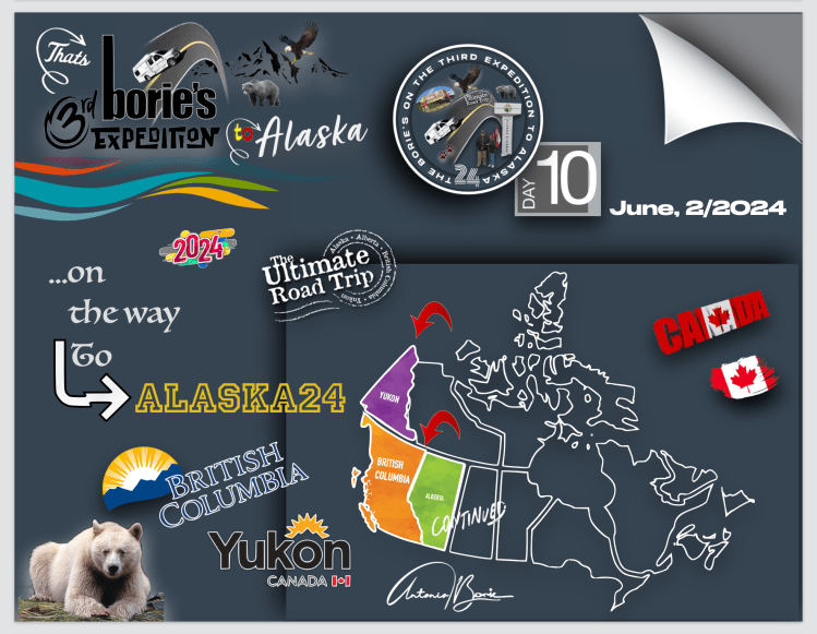
..como tal, nas fotos que publicamos para as identificar…, mencionamos apenas o número de milhas percorridas a partir do início, que é a cidade de Dawson Creek!. Então cá vai a lista das povoações e lugares históricos por onde passámos, saindo de Fort Nelson, na província de British Columbia onde pernoitámos num parque de RV, que é aproximadamente na milha 300!.
…as such, in the photos we posted to identity them…, we only mention the number of miles traveled since the beginning, which is the city of Dawson Creek!. So here is the list of towns and historic places that we passed through, leaving Fort Nelson, in the province of British Columbia, where we spent the night in an RV park, which is approximately at mile 300!.
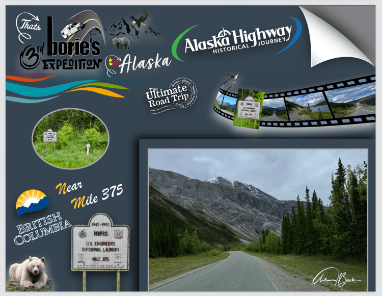
…milha 375– parámos aqui porque era a primeira civilização que encontrávamos depois de Fort Nelson!. Existem algumas casas e uma placa anunciando um motel com cabines e um campo de campismo, convidando os viajantes a parar e ir caminhar até ao rio que é próximo!. O local é convidativo e tem um poste anunciando a sua localização, dando-nos a ideia de que durante a construção desta hoje histórica estrada foi uma estação de trabalho de engenheiros!.
…mile 375 – we stopped here because it was the first civilization we encountered after Fort Nelson!. There are some houses and a sign advertising a motel with cabins and a campsite, inviting travelers to stop and go for a walk to the nearby river!. The place is inviting and has a post announcing its location, giving us the idea that during the construction of this now historic road it was an engineers’ work station!.
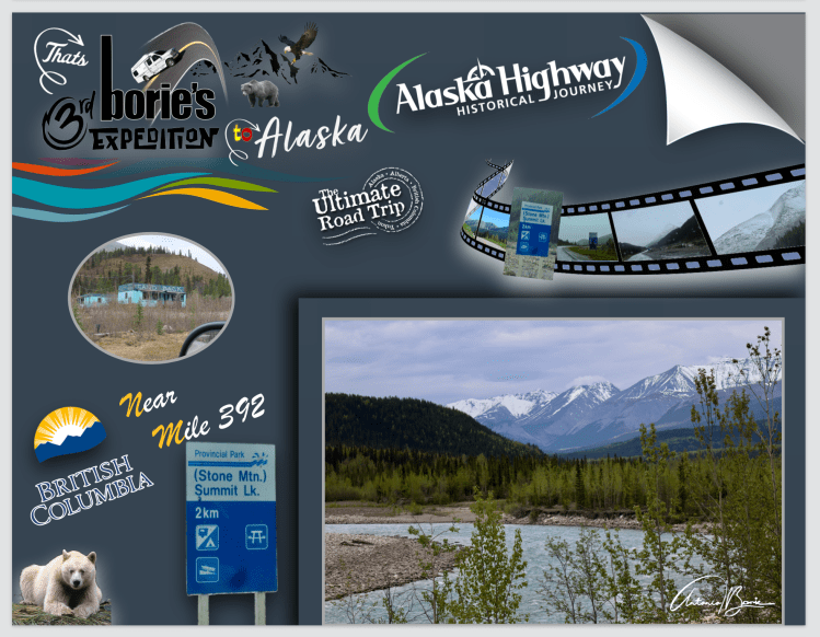
…milha 392 – nesta área passamos por montanhas com neve e em baixo lagos de água pura!.Estava frio e havia chuviscos, no entanto, o “Stone Mountain Provincial Park” é uma área maravilhosa de deserto montanhoso!. Das curvas na estrada que circundavam as montanhas, podemos admirar um cenário único, com alguns rebanhos de caribus tentando entrar nos lagos que por ali havia!. Era um cenário que só se pode admirar talvez uma vez na vida!.
…mile 392 – in this area we passed through snowy mountains and below lakes of pure water!.It was cold and there was drizzle, however, “Stone Mountain Provincial Park” is a wonderful area of mountainous desert!. From the curves in the road that surround the mountains, we can admire a unique scene, with some herds of caribou trying to enter the lakes that were there!. It was a scene that you can only admire maybe once in your life!.
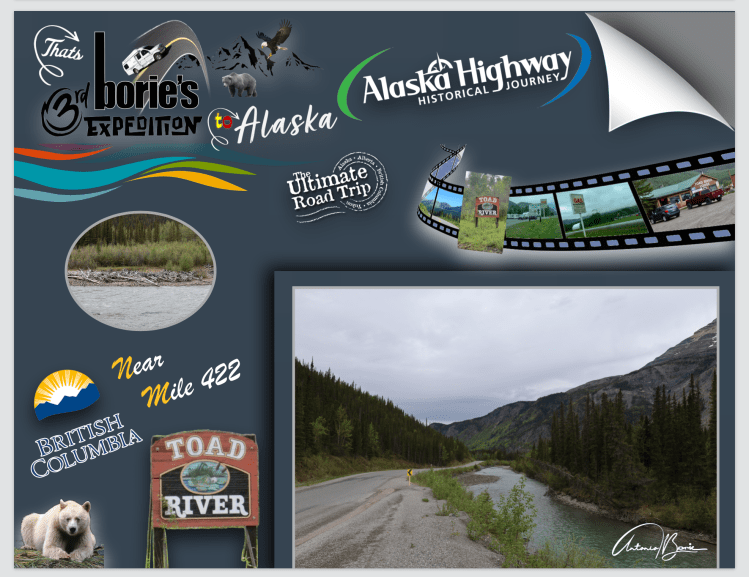
…milha 422 – durante o nosso percurso, cruzámo-nos com muitas caravanas oriundas dos mais exóticos lugares no mundo, até da Austrália!. Todavia existem muitas histórias de como lugares diferentes receberam seus nomes ao longo desta hoje famosa e histórica estrada e, este pequeno oásis no meio de nada, dá pelo nome de “Pousada Rio Sapo”, quando por volta de 1942, os exércitos canadense e norte-americano estavam ocupados construindo esta estrada!. Tem uma curiosidade, é que no tecto do salão de entrada tem mais de 7.500 chapéus de todo o mundo!.
…mile 422 – during our journey, we came across many caravans coming from the most exotic places in the world, even Australia!. However, there are many stories of how different places received their names along this now famous and historic road, and this little oasis in the middle of nowhere is called “Pousada Rio Sapo”, when around 1942, the Canadian and Northern armies -American were busy building this road!. What’s interesting is that on the ceiling of the entrance hall there are more than 7,500 hats from all over the world!
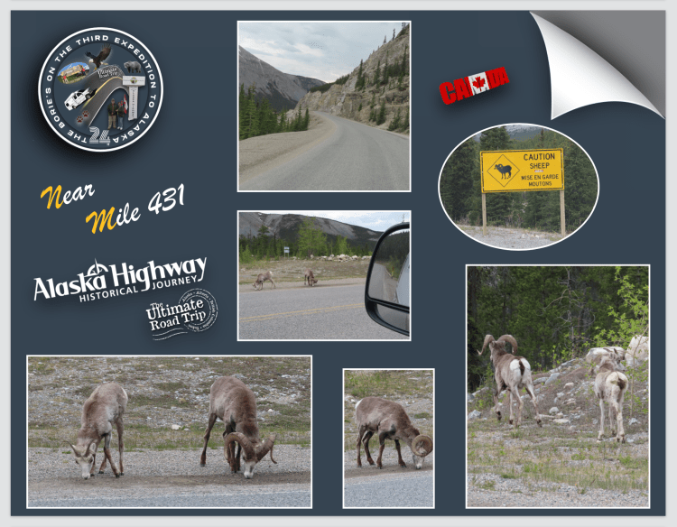
…milha 431 – foi um pouco antes de entrar na área do “Lago Muncho”, quando as cabras de montanha apareceram na estrada procurando comer algo entre a pedra miúda que aparecia ao lado da estrada numa zona montanhosa!. Eram muitas que iam e vinham sem se preocupar com alguns veículos que transitavam!.
…mile 431 – it was just before entering the “Muncho Lake” area, when the mountain goats appeared on the road looking to eat something among the small rocks that appeared on the side of the road in a mountainous area!. There were many who came and went without worrying about some vehicles passing by!.
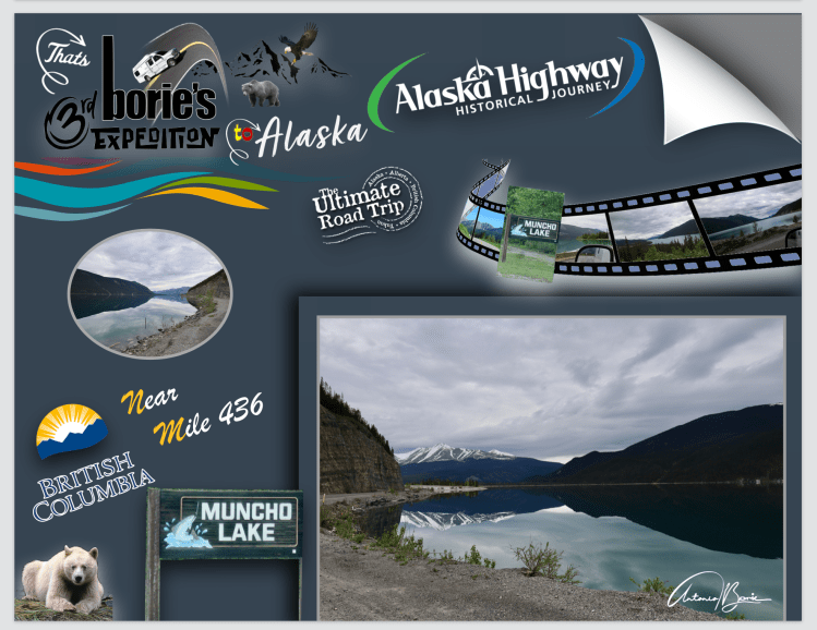
…milha 436 – começamos a ver uma cordilheira de montanhas sem qualquer vegetação, a estrada ia encostada a algumas rochas, começando a descer e prosseguindo junto à água cor de jade!. Chegámos ao “Lago Muncho”, um refúgio perfeito para fazer uma caminhada cénica à beira do lago, com água também pura, vinda da neve acumulada em milhares, talvez milhões de anos, onde existe entre outras coisas, uma boa opção para acampar no “Strawberry Campground”, onde já pernoitámos duas vezes em viagens anteriores e que, pela manhã quando abrimos a porta da caravana, deparamos com um cenário de montanha e lagos que talvez custasse “um milhão de dolares”!.
…mile 436 – we begin to see a range of mountains without any vegetation, the road leaned against some rocks, starting to descend and continuing along the jade-colored water!. We arrived at “Muncho Lake”, a perfect refuge to take a scenic walk along the lake, with also pure water, coming from the snow accumulated over thousands, perhaps millions of years, where there is, among other things, a good option for camping in the “Strawberry Campground”, where we have already stayed the night twice on previous trips and, in the morning when we opened the caravan door, we found a mountain and lake scenery that perhaps cost “a million dollars”!.
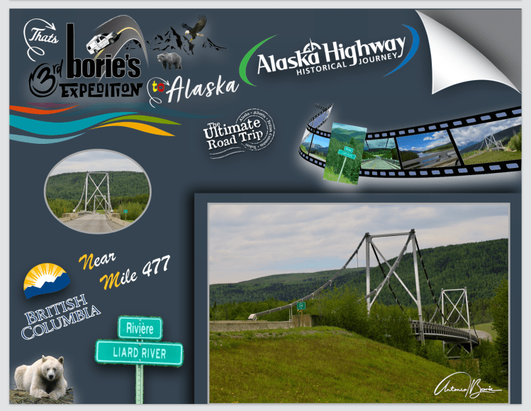
…milha 477 – reduzindo a velocidade, parámos surpreendidos com a vista da ponte “Lower Liard River”, pairando sobre uma paisagem isolada, imponente e graciosamente simétrica, construída em aço!. É uma das seis “passagens especiais” nesta hoje histórica estrada e é a única ponte suspensa em toda a sua rota!. Os engenheiros decidiram que uma ponte suspensa tinha que ser construída neste local porque as condições do gelo tornavam impossível manter os andaimes temporários necessários por tempo suficiente para construir o tipo usual da normal ponte de extensão de “treliça” em ambos os lados, construídos abaixo e não acima do leito da ponte, tal como as outras que por aqui ainda vão resistindo!.
…mile 477 – slowing down, we stopped in surprise at the view of the “Lower Liard River” bridge, hovering over an isolated, imposing and gracefully symmetrical landscape, built of steel!. It is one of six “special crossings” on this now historic road and is the only suspension bridge along its entire route!. Engineers decided that a suspension bridge had to be built at this location because ice conditions made it impossible to maintain the necessary temporary scaffolding long enough to build the usual type of normal “truss” span bridge on both sides, built below and not above the bridge bed, just like the others that are still resisting here!.
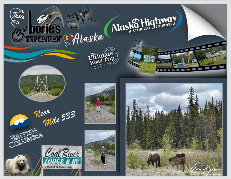
…milha 533 – viajando de caravana, de moto ou até de bicicleta, a beleza natural que ainda se pode ver por aqui é maravilhosa, tal como estes cavalos selvagens!. Alguns nomes de povoações que nos apareciam, estavam encerradas, casas sem ninguém, árvores e ramagem nascida dentro das casas, mas não deixavam de ter o seu encanto, todavia e continuando, parámos no “Coal River Lodge & RV”, onde se pode podia acampar e comprar gasolina!.
…mile 533 – traveling by caravan, motorbike or even bicycle, the natural beauty that can still be seen here is wonderful, as are these wild horses!. Some names of towns that appeared to us were closed, houses without anyone, trees and branches growing inside the houses, but they still had their charm, however, and continuing, we stopped at the “Coal River Lodge & RV”, where you could camping and buying gas!.
…até à Milha 550 – a hoje famosa e “Histórica Alaska Highway” tem quase tudo com que a natureza nos contempla!. Tem icebergs, montanhas cobertas de neve por milhar de anos, rios selvagens e lagos perdidos em florestas onde os animais vivem livres da presença humana e, ao longo da estrada, numa área que se estende por mais de 60 milhas existem letreiros avisando que existem muitos rebanhos de búfalos, compostos por machos, fêmeas, bezerros e sub adultos!. Os búfalos velhos, são solitários ou formam pequenos grupos!.
…up to Mile 550 – the now famous and “Historic Alaska Highway” has almost everything that nature contemplates!. There are icebergs, mountains covered in snow for thousands of years, wild rivers and lakes lost in forests where animals live free from human presence and, along the road, in an area that extends for more than 60 miles, there are signs warning that there are many herds of buffalo, composed of males, females, calves and sub adults!. Old buffaloes are solitary or form small groups!
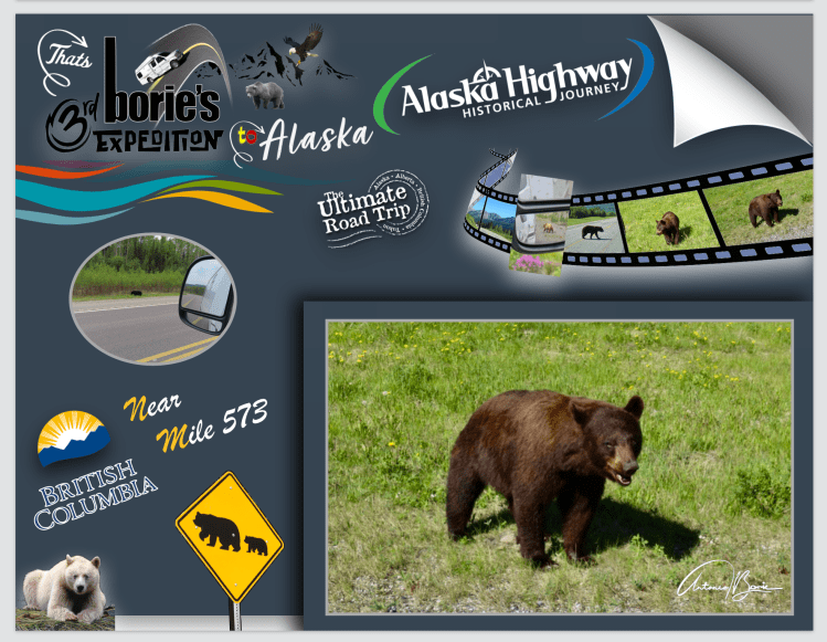
…milha 573 – viajando em todo o seu percurso nesta hoje histórica estrada, temos a oportunidade de apreciar, algumas planícies, montanhas, “glacieres”, animais e aves selvagens, lagos, rios revoltosos, alguns de água quente, árvores, vistas de montanha que não se tem oportunidade nunca na vida de um ser humano poder ver, tal como ursos que ou atravessam a estrada ou se alimentam ao seu redor, demarcando sempre o seu território!.
…mile 573 – traveling along its entire route on this now historic road, we have the opportunity to appreciate some plains, mountains, “glaciers”, wild animals and birds, lakes, wild rivers, some with hot water, trees, mountain views that you never have the opportunity in your life for a human being to see, such as bears that either cross the road or feed around it, always demarcating their territory!.
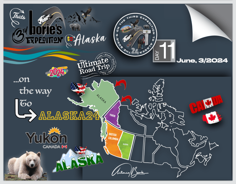
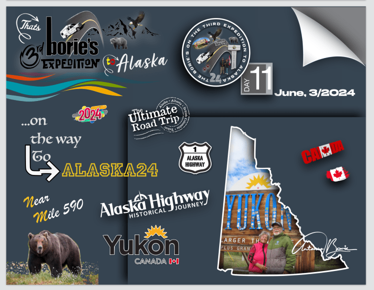
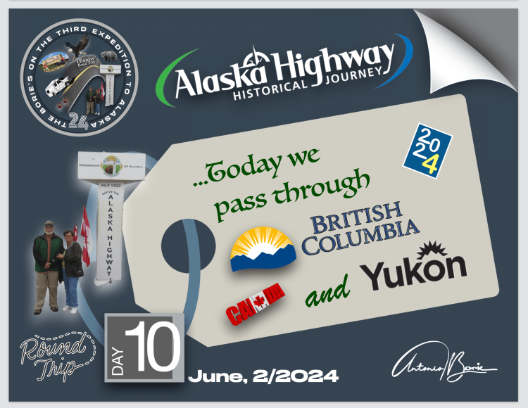
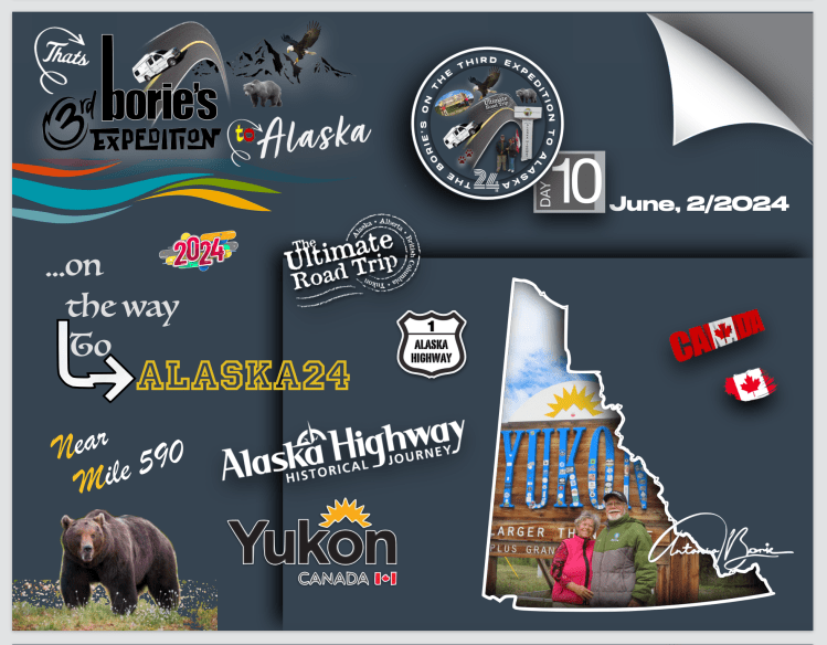
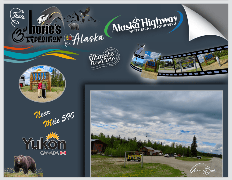
…milha 590 – entretanto, somos Bem-Vindos ao território do Yukon!. Parámos aqui por momentos no histórico lugar de Contact Creek, nome dado pelos soldados do 35.º Regimento do sul e pelo 340.º Regimento do norte, que se encontraram aqui em Setembro de 1942, completando o sector sul da hoje famosa e “Histórica Alaska Highway”!. O Yukon, é um território no noroeste do Canadá, é selvagem, montanhoso e pouco povoado!.
…mile 590 – in the meantime, we are Welcome to the Yukon Territory!.We stop here for a moment at the historic site of Contact Creek, named for the soldiers of the southern 35th Regiment and the northern 340th Regiment, who met here in September 1942, completing the southern sector of the now famous “Historic Alaska Highway”!. The Yukon, a territory in northwestern Canada, is wild, mountainous and sparsely populated!.
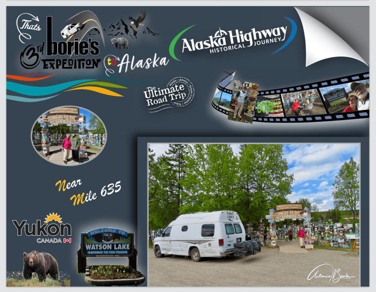
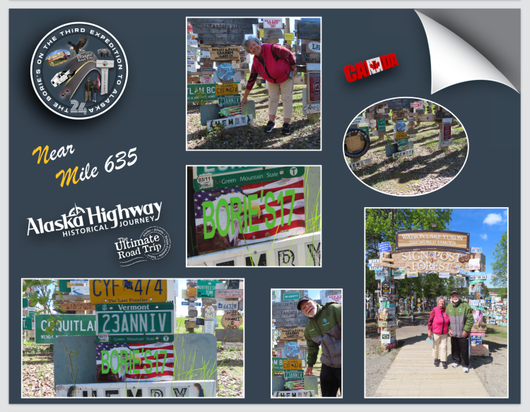
…milha 635 – chegámos ao Lago Watson, que é uma cidade já no território do Yukon!. Aqui, fomos ver a placa que há sete anos deixámos neste local, assinalando uma das nossas passagens, na atracção turística que dá pelo nome de “Signpost Forest” iniciada no ano de 1942, por um soldado do Exército dos USA que se encontrava doente e trabalhava na hoje famosa “Histórica Estrada do Alaska”, e com saudades da sua cidade natal, colocou um sinal com o nome de sua cidade natal e a distância!. Tal como nós, outros seguiram o exemplo e a tradição continua até hoje, onde já existem mais de 76,000 sinais de vários tipos que retratam locais em todo o mundo!.
…mile 635 – we arrive at Watson Lake, which is a city already in the Yukon Territory!. Here, we went to see the sign that we left in this place seven years ago, marking one of our passages, in the tourist attraction that goes by the name “Signpost Forest”, started in 1942, by a US Army soldier who was sick and working on the now famous “Historic Alaska Highway”, and missing his hometown, he put up a sign with the name of his hometown and the distance!. Just like us, others followed suit and the tradition continues today, where there are now over 76,000 signs of various types depicting places around the world!.
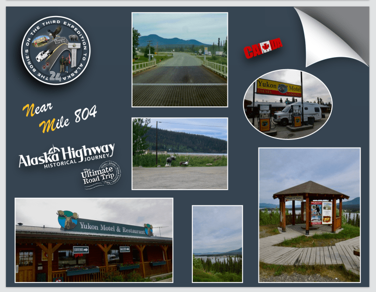
…milha 804 – Aqui pernoitámos num parque de RV, terminando a nossa aventura por hoje!. Foi na pequena localidade de Teslin, que está situada ao longo do Lago com o mesmo nome e onde no ano de 1903 a Hudson’s Bay Company estabeleceu uma pequena posição comercial, sendo também o lar da primeira nação “Teslin Inland Tlingit First”, tendo assim uma das maiores populações nativas do território do Yukon, de onde parte da sua subsistência gira em torno da caça tradicional, usando por vezes ratoeiras e da pesca!. Parámos antes, num lindo miradouro sobre o lago de Teslin, onde se pode admirar a ponte e a povoação!.
..mile 804 – We spent the night here at an RV park, ending our adventure for today!. It was in the small town of Teslin, which is located along the Lake of the same name and where in 1903 the Hudson’s Bay Company established a small commercial position, and is also home to the “Teslin Inland Tlingit First” nation, thus having a one of the largest native populations in the Yukon Territory, where part of their subsistence revolves around traditional hunting, sometimes using mousetraps and fishing!. We stopped first, at a beautiful viewpoint over Lake Teslin, where you can admire the bridge and the village!.
…o dia estava excelente, a manhã a raiar com algum sol, o céu estava quase azul, a temperatura era de uma primavera semi-tropical, nem parecia que estávamos no norte do Alaska!.
…the day was excellent, the morning dawned with some sun, the sky was almost blue, the temperature was that of a semi-tropical spring, it didn’t even feel like we were in northern Alaska!.
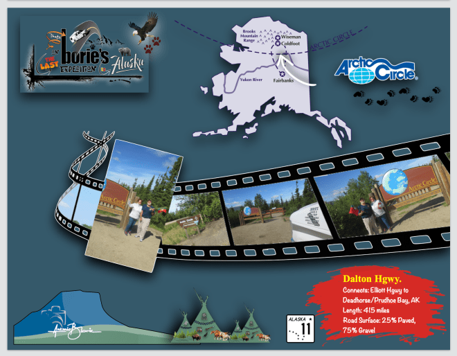
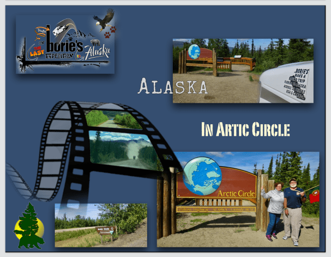
…era um dia especial!. Queríamos completar uma aventura que já se prolongava por alguns anos, que era viajar na famosa “Estrada Dalton”!. No passado já a havíamos tentado, estando no início desta famosa estrada, percorrendo mesmo algumas milhas…, mas a chuva, o nevoeiro, o vento, o frio, a neve e os acidentes que havia pelo percurso, além dos avisos feitos pelas pessoas de uniforme, alguns eram militares, que frequentemente nos apareciam, fizeram com que desanimados, voltasse-mos para trás, desistindo, percorrendo um caminho de regresso, de alguma revolta, jurando que um dia havia-mos de nela viajar, pelo menos até ao “Circulo Polar Ártico”!.
…it was a special day! We wanted to complete an adventure that had been going on for a few years, which was traveling on the famous “Dalton Highway”!. In the past we had already tried it, being at the beginning of this famous road, covering just a few miles…, but the rain, the fog, the wind, the cold, the snow and the accidents along the way, in addition to the warnings given by people from uniform, some were military, who frequently appeared to us, made us discouraged, turned back, giving up, following a path of return, of some revolt, swearing that one day we would travel in it, at least until the “Arctic Circle”!.
…e anos depois, numa segunda tentativa fomos abençoados com ventos suaves e céu limpo!. Aqui e ali ainda nos apareciam…, alguma lama, poeira, pedra miúda ou buracos, mas a tal chuva, neve ou granizo, enormes geadas, buracos e rachaduras na estrada, felizmente não!. Como tal…, perfeitamente nos adaptámos!.
…and years later, on a second attempt we were blessed with gentle winds and clear skies!. Here and there we still saw some mud, dust, small stones or holes, but not so much rain, snow or hail, huge frosts, holes and cracks in the road, fortunately not! As such… we adapted perfectly!
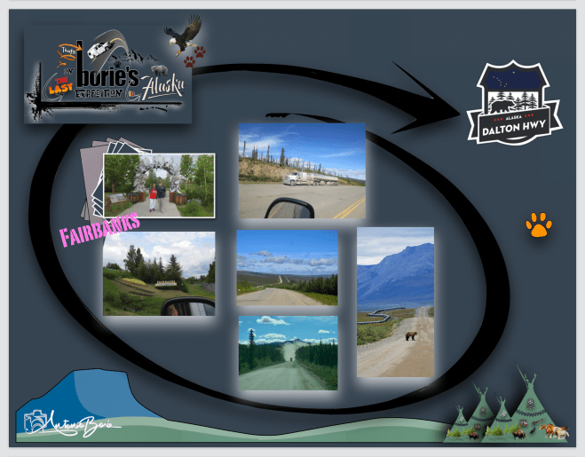
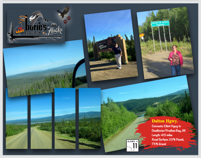
…a ”EstradaDalton” é uma estrada de 414 milhas (666 km) que começa na“Estrada Elliott, ao norte da cidade de Fairbanks e termina em Deadhorse, uma comunidade da Baía de Prudhoe, perto do Oceano Ártico e dos Campos Petrolíferos da Baía de Prudhoe!. Hoje chama-se “Estrada Dalton”, em homenagem ao engenheiro James W. Dalton, especialista em engenharia do Ártico, actuando como consultor em exploração de petróleo no norte do Alaska, todavia já foi chamada de “North Slope Haul Road”, um nome pelo qual ainda é conhecida às vezes e que, foi construída como uma estrada de suprimento para apoiar o Sistema de Oleodutos Trans-Alaska no ano de 1974!.
…the “Dalton Highway” is a 414-mile (666 km) road that begins at “Elliott Highway”, north of the city of Fairbanks and ends in Deadhorse, a Prudhoe Bay community near the Arctic Ocean and the Oil Fields Prudhoe Bay!. Today it is called “Dalton Highway”, in honor of the engineer James W. Dalton, a specialist in Arctic engineering, acting as a consultant in oil exploration in northern Alaska, however it was once called “North Slope Haul Road”, a name which it is still sometimes known as, was built as a supply road to support the Trans-Alaska Pipeline System in 1974!.
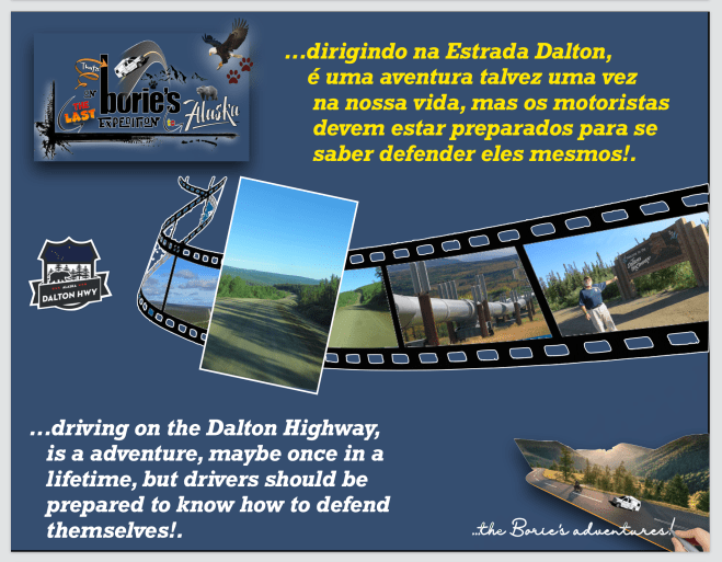
…aqui recomeçou a aventura que frustrados e revoltados, fomos obrigados a desistir uns anos atrás!. O dia estava mesmo a nosso favor, estava um céu limpo e não era necessário esperar por outros aventureiros, como tal fomos em frente, sabendo que o lema era, “conduzir na Estrada Dalton, é uma aventura, talvez uma vez na vida, mas os motoristas devem preparar-se para se saber defender sózinhos”!.
…here the adventure that frustrated and angry, we were forced to give up a few years ago, began again!. The day was really in our favor, it was a clear sky and there was no need to wait for other adventurers, so we went ahead, knowing that the motto was, “driving the Dalton Highway, it’s an adventure, maybe once in a lifetime, but Drivers must prepare themselves to know how to defend themselves”!
…a “Estrada Dalton” é a única estrada no estado do Alaska que atravessa o “Círculo Polar Ártico”, que é o ponto mais ao norte, dos abstratos ou imaginários principais círculos de latitude, como é mostrado nos mapas da Terra!. Ele marca o ponto mais setentrional no qual o sol do meio-dia é visível no solstício de inverno do norte, e o ponto mais ao sul no qual o sol da meia-noite é visível no solstício de verão do norte!. A região ao norte deste círculo é conhecida como o Ártico, e a zona apenas para o sul é chamada de Zona Temperada Norte!.
…the “Dalton Highway” is the only road in the state of Alaska that crosses the “Arctic Circle”, which is the northernmost point of the abstract or imaginary main circles of latitude, as shown on maps of the Earth! . It marks the northernmost point at which the midday sun is visible on the northern winter solstice, and the southernmost point at which the midnight sun is visible on the northern summer solstice!. The region north of this circle is known as the Arctic, and the zone just to the south is called the North Temperate Zone!
…e nós ao cruzarmos este ponto, ficámos fascinados e algo surpresos por ver este fenómeno, pois ao norte do “Círculo Polar Ártico”, o sol está acima do horizonte por vinte e quatro horas contínuas pelo menos uma vez por ano, portanto, visível à meia-noite e, abaixo do horizonte por vinte e quatro horas contínuas pelo menos uma vez por ano, portanto, não visíveis ao meio dia, isso também é verdade dentro do Círculo Polar equivalente no Hemisfério Sul, o Círculo Antártico. A posição do Círculo Ártico não é fixa, mas o normal é 66º33’46.8 graus ao norte do Equador!.
…and when we crossed this point, we were fascinated and somewhat surprised to see this phenomenon, because north of the “Arctic Circle”, the sun is above the horizon for twenty-four continuous hours at least once a year, therefore visible at midnight and, below the horizon for twenty-four continuous hours at least once a year, therefore not visible at noon, this is also true within the equivalent Polar Circle in the Southern Hemisphere, the Antarctic Circle. The position of the Arctic Circle is not fixed, but the normal is 66º33’46.8 degrees north of the Equator!.
…algumas curiosidades do “Círculo Polar Ártico” é que passa por sete países que possuem uma porção considerável de terra dentro do seu círculo, que são países como os USA, Groenlândia, Canadá, Rússia, Noruega, Suécia ou Finlândia, no entanto, a Islândia tem uma pequena região, menos de um quilómetro quadrado, dentro do mesmo círculo!.
…some interesting facts about the “Arctic Circle” is that it passes through seven countries that have a considerable portion of land within their circle, which are countries such as the USA, Greenland, Canada, Russia, Norway, Sweden or Finland, however, the Iceland has a small region, less than a square kilometer, within the same circle!.
…a sua posição, que como acima explicámos é normalmente localizada a 66º33’46.8 graus ao norte do Equador, no entanto, a sua localização real muda ligeiramente todos os anos e.., este fenómeno deve-se à flutuação da inclinação axial da Terra, que é influenciada pela órbita da Lua e pelas consequentes mudanças nas marés!. A mesma inclinação axial causa as diferentes estações que vivemos na Terra, e actualmente, o círculo está a mover-se para o norte a uma taxa de cerca de 15 metros por ano!.
…its position, which as we explained above is normally located at 66º33’46.8 degrees north of the Equator, however, its actual location changes slightly every year and…, this phenomenon is due to the fluctuation of the Earth’s axial tilt , which is influenced by the Moon’s orbit and the resulting changes in tides!. The same axial tilt causes the different seasons we experience on Earth, and currently, the circle is moving north at a rate of about 15 meters per year!.
…para muitos, o “Círculo Polar Ártico”, ou “Pólo Norte” como é costume dizer-se, e que é frequentemente associado ao “Pai Natal” eàs renas voadoras…, no entanto, o que a maioria das pessoas não sabe é que na verdade existem quatro “Pólos Norte” reconhecidos, que são: O “Pólo Norte Geográfico”, que é o ponto mais setentrional do planeta e onde todas as linhas de longitude da Terra se encontram!.. O “Pólo Norte Magnético”, que é o local onde todas as linhas de força magnética do planeta apontam verticalmente para baixo e o seu ponto atrai a agulha de uma bússola!. O “Pólo Norte Geomagnético”, que é o extremo norte de onde o eixo da magnetosfera, ou seja, o campo magnético que envolve a Terra e se estende pelo espaço e cruza o planeta!. E finalmente, o ”Pólo Norte da Inacessibilidade”, que é o ponto do Oceano Ártico mais distante de qualquer costa!.
…for many, the “Arctic Circle”, or “North Pole” as it is customary to say, and which is often associated with “Santa Claus” and flying reindeer…, however, what most people don’t know is that there are actually four recognized “North Poles”, which are: The “Geographic North Pole”, which is the northernmost point on the planet and where all the Earth’s longitude lines meet!.. The “Magnetic North Pole” , which is the place where all the planet’s magnetic lines of force point vertically downwards and its point attracts the needle of a compass!. The “Geomagnetic North Pole”, which is the extreme north of where the axis of the magnetosphere, that is, the magnetic field that surrounds the Earth and extends through space and crosses the planet!. And finally, the “North Pole of Inaccessibility”, which is the point in the Arctic Ocean furthest from any coast!.
…e, dizem-nos que os maiores predadores terrestres da Terra são exclusivos desta região, que dão pelo nome de Ursos Polares e que são os maiores carnívoros terrestres do mundo, residindo em torno de águas cobertas de gelo e dependendo do gelo marinho para se alimentar, descansar e procriar!..
…and, we are told that the largest land predators on Earth are exclusive to this region, which they call Polar Bears and that they are the largest land carnivores in the world, residing around ice-covered waters and depending on sea ice for food. feed, rest and procreate!
…também dezenas de grupos indígenas prosperam dentro da sua região e, entre a grande população do “Círculo Polar Ártico” residem mais de 40 grupos étnicos diferentes!. Embora variem muito em cultura, língua e história, estes grupos indígenas têm uma forte ligação com as terras árticas que habitam há milhares de anos. Muitos mantêm actividades tradicionais de pesca, pastoreio de renas e caça!.
…dozens of indigenous groups also thrive within its region and, among the large population of the “Arctic Circle” there are more than 40 different ethnic groups!. Although they vary greatly in culture, language and history, these indigenous groups have a strong connection to the Arctic lands they have inhabited for thousands of years. Many maintain traditional fishing, reindeer herding and hunting activities!
…no entanto e infelizmente, os seus meios de subsistência e produtividade estão ameaçados pelas dramáticas mudanças climáticas e pelo desaparecimento do gelo marinho!.
…however, unfortunately, their livelihoods and productivity are threatened by dramatic climate change and the disappearance of sea ice!.
Tony Borie, Século XXI. (Tony Borie, 21st Century).