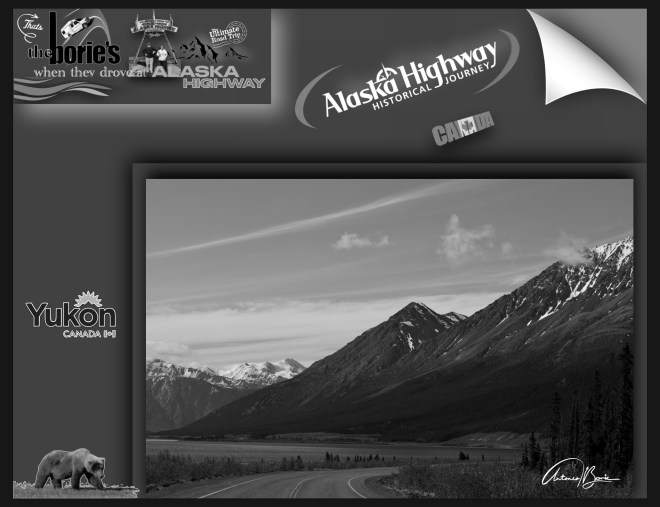
…a lendária e hoje “Histórica Alaska Highway”, entre outras coisas, é uma rota de aproximadamente 1.400 milhas, (2.400 quilómetros) que continua sendo a ligação vital entre as províncias de British Columbia e o Yukon no Canada, com o estado do Alaska, USA!.
…the legendary and today “Historic Alaska Highway”, among other things, is a route of approximately 1,400 miles, (2,400 kilometers) that remains the vital link between the provinces of British Columbia and the Yukon in Canada, with the state of Alaska, USA!.
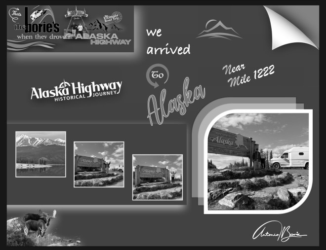
…e nós já veteranos, viajando nela pela terceira vez, estávamos a ficar mais perto do Oceano Ártico e do “sol da meia-noite”!.
…and we, now veterans, traveling on it for the third time, were getting closer to the Arctic Ocean and the “midnight sun”!.
…como tal, a aventura começava num cenário, onde nos podia surgir uma extensa planície, uma montanha, um rio selvagem ou um longo trecho de uma estrada deserta, dentro de uma tempestade de chuva constante ou de neve branca e gelada, que possivelmente já nos afligia muito menos, porque já nos considerávamos veteranos ao viajar por esta lendária estrada, e sabíamos das dificuldades e de possíveis reparações, que são muito frequentes!.
…as such, the adventure began in a scenario, where we could see an extensive plain, a mountain, a wild river or a long stretch of a deserted road, within a storm of constant rain or white, icy snow, which possibly already distressed us much less, because we already considered ourselves veterans when traveling this legendary road, and we knew the difficulties and possible repairs, which are very common!.
…esta histórica estrada, não só apoia as comunidades como serve de corredor para a vida selvagem, ligando as pessoas do Norte, milha a milha!.
…this historic road not only supports communities but serves as a wildlife corridor, connecting the people of the North, mile by mile!.
…foi construída através da natureza selvagem em apenas 8 meses, exigindo mais de 250.000 toneladas de materiais e o trabalho de 11.000 soldados, cerca de um terço dos quais eram soldados negros, membros de três regimentos segregados afro-americanos recém-formados, que viviam em campos remotos!.
…was built through wilderness in just 8 months, requiring more than 250,000 tons of materials and the labor of 11,000 soldiers, about a third of whom were black soldiers, members of three newly formed African-American segregated regiments, who lived in remote fields!
…houve a colaboração do Canadá, onde as “Primeiras Nações” da hoje províncias do Yukon e de British Columbia, compartilharam o seu conhecimento da terra, guiando o Corpo de Engenheiros do Exército dos EUA, através da mata, trilhas e armadilhas, tornando a rota possível!.
,,,there was collaboration from Canada, where the “First Nations” from today’s provinces of Yukon and British Columbia, shared their knowledge of the land, guiding the US Army Corps of Engineers, through the forest, trails and traps, making the route possible!.
…claro, ao mesmo tempo, toda esta construção ia perturbando o seu modo de vida, as suas terras, meios de subsistência e comunidades, deixando um impacto duradouro que ainda hoje é sentido!.
…of course, at the same time, all this construction was disrupting their way of life, their lands, livelihoods and communities, leaving a lasting impact that is still felt today!.
…ao longo dos anos, a hoje “Histórica Alaska Highway”, deixou de ser uma via acidentada e encharcada de chuva para se tornar um corredor de transporte totalmente pavimentado durante todo o ano, apoiando uma rota de transporte comercial, respondendo a emergências e milhares de viajantes que se dirigem para o norte todos os anos!.
…over the years, today’s “Historic Alaska Highway” has gone from a rugged, rain-soaked thoroughfare to a fully paved, year-round transportation corridor, supporting a commercial transportation route, responding to emergencies, and thousands of travelers heading north each year!
…foi construída no ano de 1942 e aberta ao tráfego civil no ano de 1948, sendo sempre renovada e modernizada consoante as frequentes derrocadas, alagamentos em pântanos e vegetação em decomposição!.
…it was built in 1942 and opened to civil traffic in 1948, always being renovated and modernized according to frequent landslides, flooding in swamps and decomposing vegetation!.
…onde vão sendo substituídas as iniciais pontes flutuantes, estacas em madeira ou piso térreo e lamacento por pontes em ferro e cimento e um pavimento em alcatrão permanentes com a sinalização possível!.
…where the initial floating bridges, wooden piles or ground and muddy floors are being replaced by iron and cement bridges and a permanent tar pavement with possible signage!.
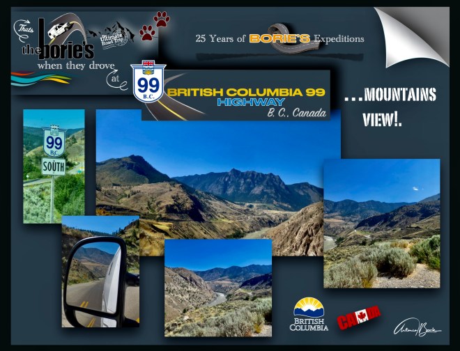
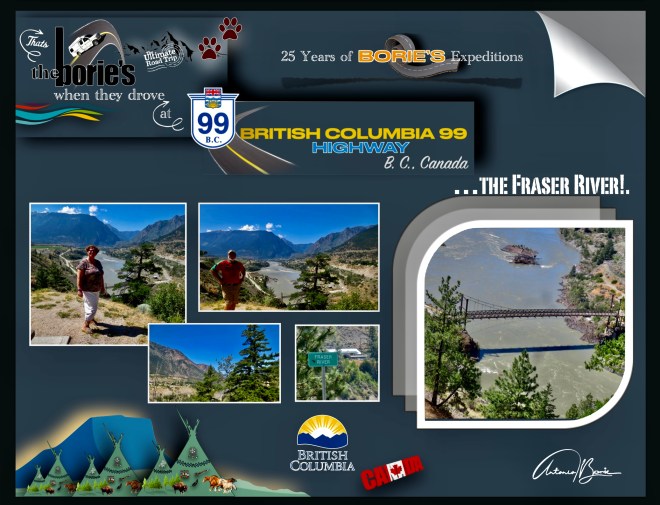
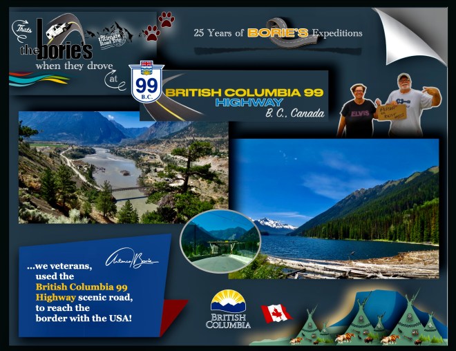
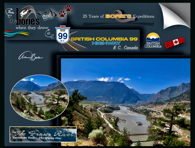
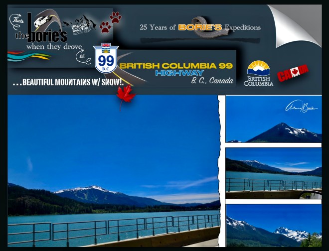
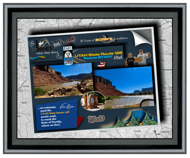
…a estrada 99 em B. C., Canadá, no ano de 2006, o jornal The Guardian, do Reino Unido, nomeou-a como a quinta melhor viagem pelo mundo!. Claro, passando lá próximo, esta notícia despertou-nos a atenção, porque nesta já um pouco avançada idade, com quase nada para perder, mantemos um lema, que para nós é apetecível, tal como, “Se isso é lindo mas te assusta, pode ser uma boa coisa para tentar”!.
…road 99 in BC, Canada, in 2006, the UK newspaper The Guardian named it as the fifth best road trip in the world!. Of course, passing by nearby, this news caught our attention, because at this slightly advanced age, with almost nothing to lose, we maintain a motto, which for us is appealing, such as, “If this is beautiful but scares you, it might be a good thing to try”!.
…como tal, aoouvir aquela simpática senhora, com sotaque de voz local, onde tínhamos parado para comprar gasolina, água e biscoitos, quando lhe perguntámos se íamos na direcção certa para poder entrar na estrada 99, pois era uma região onde o satélite não dava sinal ao nosso sistema de navegação, sorridente nos disse: Estrada 99?. É uma estrada quase deserta, que passa através das montanhas!. Se na verdade querem viajar por ela, fica mais ou menos a 1 hora ao sul, quantos quilómetros são, não sabemos!.
…as such, upon hearing that friendly lady, with a local accent, where we had stopped to buy gasoline, water and biscuits, when we asked her if we were going in the right direction to be able to enter road 99,as it was a region where the satellite did not give a signal to our navigation system, she smilingly told us: Road 99?.It is an almost deserted road, which passes through the mountains!. If you actually want to travel through it, it’s about 1 hour south, how many kilometers it is, we don’t know!
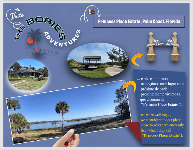
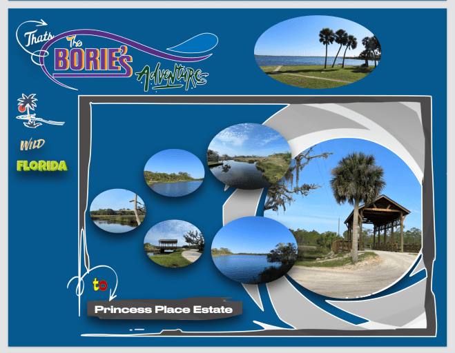
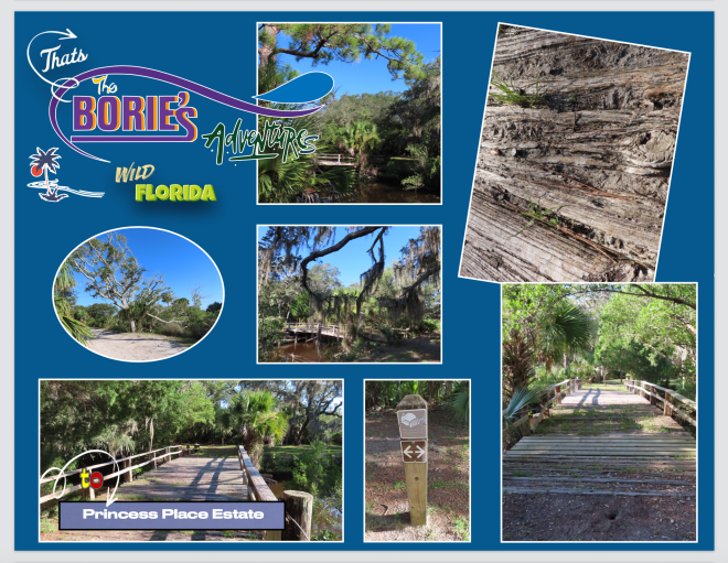
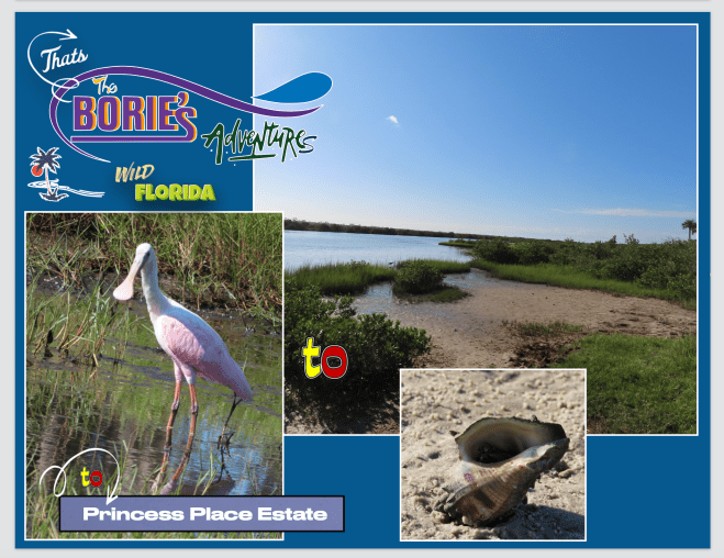
…este lugar ainda selvagem tem uma história muito rica, num cenário exótico de beleza natural, onde outrora também foi cenário de índios americanos, assentamentos coloniais, guerras, servos, magnatas, casamentos, divórcios, amor, ódios, príncipes e princesas, tudo passado neste maravilhoso local, situado na parte norte do concelho de Flagler, mais propriamente na confluência do hoje Riacho Pellicer e do Rio Matanzas!.
…this still wild place has a very rich history, in an exotic setting of natural beauty, where once it was also the scene of American Indians, colonial settlements, wars, serfs, tycoons, marriages, divorces, love, hatred, princes and princesses, everything in the past in this wonderful place, located in the northern part of the municipality of Flagler, more precisely at the confluence of today’s Riacho Pellicer and the Matanzas River!.
…a sua história diz que tudo começou por volta do final do século dezassete, quando uma parcela de mais de mil acres foi concedida como uma concessão de terras espanholas a Francisco Pellicer, homem nascido em Minorca, que é uma das ilhas Baleares de Espanha, no mar Mediterrâneo, que por aqui chegou, contratado como servo mas, tal como outros chegados da Europa, este, exercendo a profissão de agricultor e carpinteiro, prosperou no Novo Mundo!.
…his story goes that it all started around the end of the seventeenth century, when a plot of over a thousand acres was granted as a Spanish land grant to Francisco Pellicer, a man born in Minorca, which is one of the Balearic Islands of Spain, in the Mediterranean Sea, who arrived here, hired as a servant but, like other arrivals from Europe, this one, exercising the profession of farmer and carpenter, prospered in the New World!.
…Francisco Pellicer, por um período de quase quarenta anos, por aqui viveu com sua família, cultivando milho, cana e algodão, cujas culturas, uns anos mais tarde foram destruídas e queimadas durante as Guerras Indianas, que foram uma trama ou mesmo uma conspiração, depende do que lhe queiram chamar, que também ficaram conhecidas como “Cherokee Grove”!.
...Francisco Pellicer, for a period of almost forty years, lived here with his family, growing corn, sugar cane and cotton, whose crops, a few years later, were destroyed and burned during the Indian Wars, which were a plot or even a conspiracy, depends on what you want to call it, which also became known as “Cherokee Grove”!.
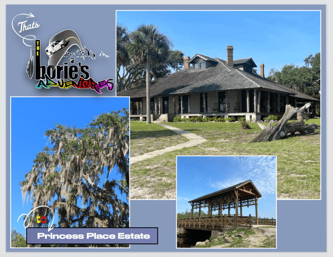
…entretanto, um tal Henry Cutting, com apenas 24 anos, que era um rico descendente dos holandeses que compraram Manhattan, lá no norte, em Nova York, estabeleceu-se por aqui com um dos primeiros laranjais na Flórida e, já por volta do final do século dezoito, comprou “Cherokee Grove” e várias parcelas adjacentes para aumentar a sua propriedade para os aproximadamente 1.500 acres, que hoje são a dimensão deste maravilhoso cenário de beleza natural, dizendo que neste maravilhoso cenário iria construir um pavilhão de caça!.
…however, a certain Henry Cutting, only 24 years old, who was a wealthy descendant of the Dutch who bought Manhattan, up north, in New York, established himself here with one of the first orange groves in Florida and, for Around the end of the eighteenth century, he purchased“Cherokee Grove” and several adjacent parcels to increase his property to approximately 1,500 acres, which today is the size of this wonderful setting of natural beauty, saying that in this wonderful setting he would build a hunting lodge!.
…e, querendo dar um ar tropical, para receber os seus hóspedes, plantou uma linha de palmeiras emparelhadas, que hoje combina perfeitamente com os carvalhos gigantescos e centenários, cobertos de musgo e envoltos em videiras selvagens, iniciando assim uma história nesta área, outrora habitada pelos índios americanos Cherokee, onde entraram príncipes e princesas!.
…and, wanting to give a tropical feel to welcome his guests, he planted a line of paired palm trees, which today combine perfectly with the gigantic and centenary oaks, covered in moss and wrapped in wild vines, thus starting a story in this area, once inhabited by the Cherokee American Indians, where princes and princesses entered!.
…porquê?. Porque Henry Cutting, trouxe a sua noiva de nome Angela para cá, casando-se por volta do ano de 1888, ano em que o seu pavilhão de caça, que era uma autêntica pousada terminou!. Ela, a Angela, adorou conviver e hospedar os seus amigos de Nova York mas, quatro anos depois, após a morte repentina de Henry Cutting, a Angela realizou um seu novo casamento com um magnata de Nova York!.
…why?. Because Henry Cutting brought his bride named Angela here, getting married around the year 1888, the year in which his hunting lodge, which was an authentic inn, ended!. She, Angela, loved hanging out and hosting her New York friends, but four years later, after the sudden death of Henry Cutting, Angela remarried to a New York tycoon!.
…cujo casamento durou pouco mais de um ano que, após um divórcio rancoroso, ela a Angela, passados três anos casou de novo, agora com um príncipe russo exilado, de nome Boris Sherbatow, ganhando o título de princesa!. O agora “casal real”, viveu no ainda “Cherokee Grove”, que foi sua casa por duas décadas e meia e, quando ela, a Angela, se tornou mais princesa real do que o príncipe Boris, logo este maravilhoso cenário de palmeiras, carvalhos gigantescos e centenários, cobertos de musgo e envoltos em videiras selvagens, ficou conhecido como “Lugar da Princesa”, enquanto isso, juntos, ele e a Angela, entretinham outros membros da realeza e a sociedade internacional, aqui no agora “Lugar da Princesa”!.
…whose marriage lasted just over a year that, after a bitter divorce, she and Angela, after three years married again, now with an exiled Russian prince, named Boris Sherbatow, earning the title of princess!. The now “royal couple”, lived in the still “Cherokee Grove”,which was their home for two and a half decades and, when she, Angela, became more of a royal princess than Prince Boris, soon this wonderful scenery of palm trees, gigantic, centuries-old oaks, covered in moss and draped in wild vines, it became known as “Place of the Princess”, meanwhile, together, he and Angela, entertained other members of royalty and international society, here in the now “Place of the Princess”!.
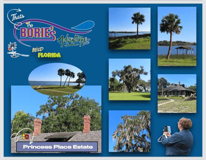
…resumindo…, assim que a Angela assumiu o título de princesa, foi quando o outrora chamado “Cherokee Grove” passou a ser conhecido como “Lugar da Princesa” e, o mais fascinante é que, o alojamento original, construído por Henry Cutting, nos dias de hoje ainda é a estrutura intacta mais antiga do Condado de Flagler!.
…in short…, as soon as Angela assumed the title of princess, that’s when what was once called “Cherokee Grove” became known as “Princess Place”and, the most fascinating thing is, the original lodge, built by Henry Cutting, to this day it is still the oldest intact structure in Flagler County!.
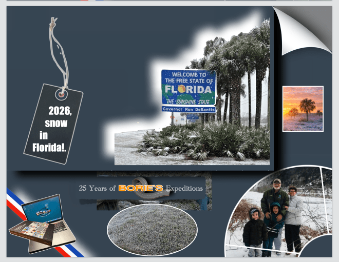
…já é o segundo ano e…, ver neve dois anos seguidos aqui no estado da Flórida, é uma sensação incrivelmente mágica e algo que nunca considerávamos que podia ter acontecido!. Faz-nos lembrar quando visitamos a família no estado de Pennsylvania!.
…it’s the second year already and…seeing snow two years in a row here in the state of Florida is an incredibly magical feeling and something we never thought could have happened!. It reminds us of when we visited family in the state of Pennsylvania!
…o sistema de aquecimento na nossa casa, trabalhou por alguns períodos de 24 horas seguidas!. Porquê?. Porque uma tremenda nevasca, tal como uma tempestade de inverno, transformou o nosso quintal e quase toda a área onde vivemos, num cenário digno de um qualquer estado do norte!.
…the heating system in our house worked for periods of 24 hours straight!. Why?. Because a tremendous snowstorm, like a winter storm, transformed our backyard and almost the entire area where we live into a scene worthy of any northern state!.
…e, “the six o’clock news” (noticiário das seis horas), dizia mais ou menos que, “depois que alertas de tempestade de inverno, em algumas partes do sul dos Estados Unidos, a neve chegou até Pensacola, na Flórida e, uma nevasca transformou o cenário em algumas partes do Panhandle da Flórida, do centro da Geórgia e do sul do Alabama”!.
…and, “the six o’clock news” said something like, “after winter storm warnings in parts of the southern United States, snow reached Pensacola, Florida, and a snowstorm transformed the landscape in parts of the Florida Panhandle, central Georgia, and southern Alabama!”
…com estas notícias, principalmente em algumas partes da Flórida, alguns moradores até ficaram acordados para ver a rara neve e para aqueles que esperaram, havia algumas cenas bastante incomuns para serem vistas, porque alguns flocos de neve caíram na praia!.
…with this news, especially in parts of Florida, some residents even stayed up to see the rare snow, and for those who waited, there were some rather unusual scenes to behold, as some snowflakes fell on the beach!
…e principalmente na região noroeste da Flórida, podia ver-se uma paisagem branca como a neve, dificultando o tráfico ao longo das principais estradas, lembrando-nos a camada de neve que nos visitou quase exatamente há um ano, quando da Tempestade de Inverno Enzo, um evento raro que trouxe neve intensa para a Costa do Golfo!.
…and especially in the northwest region of Florida, a snow-white landscape could be seen, hindering traffic along the main roads, reminding us of the snow layer that visited us almost exactly a year ago during Winter Storm Enzo, a rare event that brought heavy snow to the Gulf Coast!
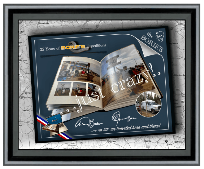
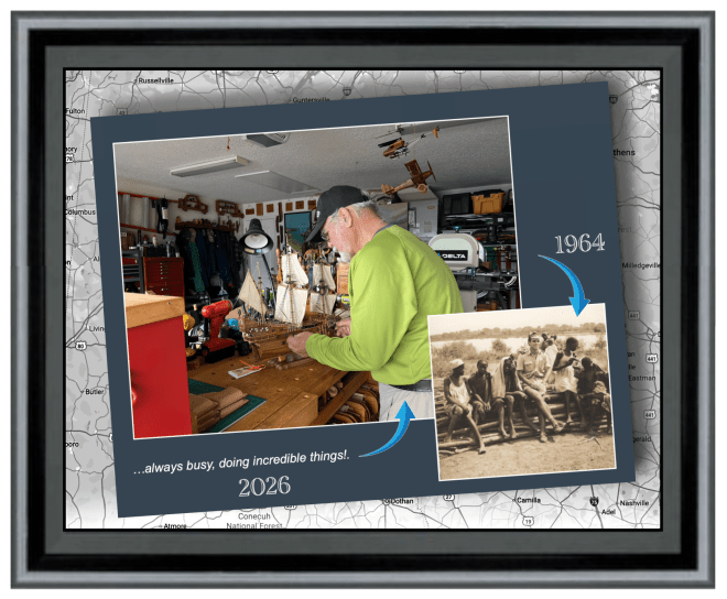
…passando já as oito dezenas de anos de idade na juventude da velhice e, depois de deixar o mercado de trabalho aos 65, sempre na companhia da nossa dedicada esposa Isaura, (que entre outras coisas sabe fotografar), temos realizado o máximo de viagens possíveis, dentro das nossas limitadas possibilidades financeiras, acampando, preparando a comida e dormindo na nossa pequena e antiga RV, que carinhosamente baptizámos como a louca “Raposa Branca”, da qual nos orgulhamos muito!.
…having already spent eight decades in the youth of old age and, after leaving the job market at 65, always in the company of our dedicated wife Isaura,(who, among other things, knows how to photograph), we have taken as many trips as possible, within our limited financial possibilities, camping, preparing food and sleeping in our small and old RV, which we affectionately named the crazy “White Fox”,of which we are very proud!.
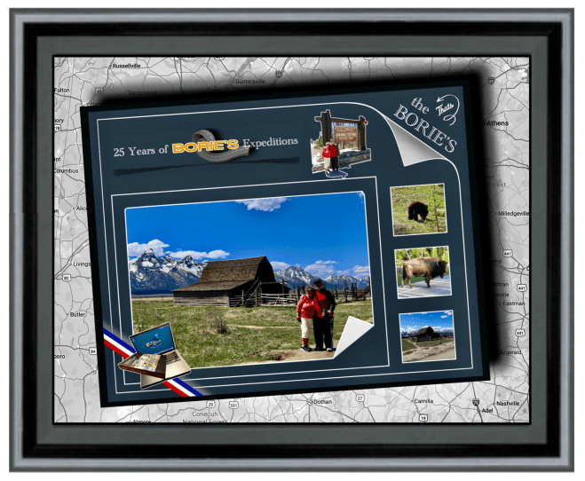
…entre outras viagens, já realizámos três expedições desde o estado da Flórida ao estado do Alaska, várias viagens completas pela Rota 66, percorrendo aproximadamente 80% das estradas mais perigosas, emocionantes e intimidantes dos EUA e Canadá, algumas com declives acentuados, ziguezagues intermináveis, mudanças climáticas repentinas e vistas que exigem toda a nossa atenção, visitando aproximadamente 90% dos parques nacionais dos EUA e do Canadá, incluindo uma expedição à Terra Nova e Labrador, no Canadá!.
…among other trips, we have already carried out three expeditions from the state of Florida to the state of Alaska, several complete trips along Route 66, covering approximately 80% of the most dangerous, exciting and intimidating roads in the USA and Canada, some with steep slopes, endless zigzags, sudden climate changes and views that demand our full attention, visiting approximately 90% of the national parks in the USA and Canada, including an expedition to Newfoundland and Labrador, Canada!.
…passando por cidades, vilas, aldeias ou parques nacionais, com temperaturas de calor algumas vezes infernal, frio ou neve, chuva, lama, poeira ou pedra miúda, seguindo por milhas e milhas o “carro piloto” em reparações ou desvios de estradas destruídas por avalanches, ou até ventos fortes tal qual tornados, e…, também lindos dias de céu azul, através de grandes rios ou pequenos riachos com forte ou pequena corrente ou até lagos com água pura!.
…passing through cities, towns, villages or national parks, with sometimes infernal heat, cold or snow, rain, mud, dust or small rocks, following for miles and miles the “pilot car”in repairs or detours on roads destroyed by avalanches, or even strong winds such as tornadoes, and…, also beautiful days with blue skies, through large rivers or small streams with strong or small currents or even lakes with pure water!.
…muitas vezes fomos atraídos por aventuras ao ar livre, explorando lugares históricos ou simplesmente mergulhando numa atmosfera descontraída, como por exemplo, parando numa estrada num lugar quase deserto, vivendo aquilo que não é comum e que nos pode surpreender, porque estava chovendo e…, olhando o relógio da nossa “Raposa Branca” (caravana), eram onze e meia da noite, no entanto, ainda era de dia, a chuva vinha do norte e estávamos no norte, como tal…, ela vinha do céu e caía direita sobre nós!.
…we were often attracted by outdoor adventures, exploring historical places or simply immersing ourselves in a relaxed atmosphere, for example, stopping on a road in an almost deserted place, experiencing something that is unusual and that might surprise us, because it was raining and… , looking at the clock in our “White Fox” (caravan), it was half past eleven at night, however, it was still daytime, the rain was coming from the north and we were in the north, as such…, it came from the sky and fell straight about us!.
…tivemos a felicidade de apreciar cenários panorâmicos semelhante a uma viagem no tempo, aprendendo sempre, porque tivemos a oportunidade de poder explorar exposições e artefactos que nos ofereceram informações sobre um passado duma qualquer região, que às vezes abrigava tesouros históricos, proporcionando-nos uma apreciação mais profunda do seu significado cultural!.
…we had the happiness of enjoying panoramic scenes similar to a journey through time, always learning, because we had the opportunity to explore exhibitions and artefacts that offered us information about the past of any region, which sometimes housed historical treasures, providing us with a deeper appreciation of its cultural significance!.
…ao longe víamos grandes ou pequenas montanhas cobertas de neve, outras cobertas com floresta, estradas com duas vias e rápidas, outras pequenas, com curvas e precipícios, com o piso em lama e água!. Parávamos aqui e ali, para admirar a natureza pura, com os animais selvagens ou águias de colarinho branco, no seu próprio território, onde nós sim…, éramos os intrusos que ocupávamos o seu espaço!.
…in the distance we saw large or small mountains covered in snow, others covered with forest, roads with two lanes and fast, others small, with curves and precipices, with mud and water on the floor!. We stopped here and there, to admire the pure nature, with wild animals or white-collared eagles, in their own territory, where we were…, we were the intruders who occupied their space!.
…vimos e fomos convivendo com pessoas de outras latitudes, mas com o mesmo sentido de aventura, muitas vezes debaixo de um sol radiante, outras, tal como acima já descrevemos, neve, chuva lama ou poeira e nuvens escuras e…, não sabendo onde era o nosso destino para esse dia, ou onde pernoitaríamos!.
…we saw and lived with people from other latitudes, but with the same sense of adventure, often under a radiant sun, other times, as we described above, snow, rain, mud or dust and dark clouds and…, not knowing where was our destination for that day, or where we would spend the night!.
…às vezes somos agraciados e aquecidos pela maravilhosa luz do sol que, depois de passar aproximadamente pelo paralelo 48º N, nos beneficia de 16 a 20 horas por dia e, nos pode levar na tal aventura como acima referimos, com alguma neve, chuva, pedras e poeira, lama, sol e algumas das paisagens mais bonitas do mundo, porque tanto nós como a nossa dedicada esposa Isaura, continuamos a querer ser bem-vindos a este mundo!.
…sometimes we are graced and warmed by the wonderful sunlight that, after passing approximately the 48º N parallel, benefits us from 16 to 20 hours a day and can take us on that adventure as mentioned above, with some snow, rain, stones and dust, mud, sun and some of the most beautiful landscapes in the world, because both we and our dedicated wife Isaura,continue to want to be welcomed into this world!.
…estivemos e passámos a linha divisória do Polo Norte, com algum sol por 24 horas, onde nunca era de noite!. Áreas desertas, onde viajávamos por centenas de milhas sozinhos, confiando na sorte e, na nossa “Raposa Branca” (caravana)!. Tomando banho em lagos de água cristalina e quente, que brotava das profundezas do planeta Terra e, a chuva miudinha caindo nas nossas cabeças!.
…we were and passed the North Pole dividing line, with some sun for 24 hours, where it was never night!. Deserted areas, where we traveled for hundreds of miles alone, trusting in luck and in our “White Fox” (caravan)!. Bathing in lakes of crystal clear, warm water, which flowed from the depths of planet Earth and the light rain falling on our heads!.
…aqui e ali paramos, porque encontramos a aventura pendurada numa corda, ao lado duma montanha, dum rio selvagem, numa estrada deserta, mesmo dentro de uma tempestade, onde milhares ou milhões de pés (ou metros cúbicos), de chuva constante, ou a mesma quantidade de neve branca e gelada, nos causam algumas dificuldades mas, se na verdade queremos saber verdadeiramente quem somos, teremos que viajar até que ninguém saiba o nosso nome!.
…here and there we stop, because we find adventure hanging from a rope, on the side of a mountain, a wild river, on a desert road, even in a storm, where thousands or millions of feet (or cubic meters), of constant rain, or the same amount of white and cold snow, cause us some difficulties but,if we really want to truly know who we are, we will have to travel until no one knows our name!.
…e, não existe nada melhor do que o silêncio e o cenário de uma montanha coberta de neve, de um lago natural, cujo fundo é uma montanha ao contrário, onde os minerais que o compõem, dão tonalidades diferentes à sua água, consoante a luz natural do sol que nele se reflete, ou tomar banho num rio selvagem de água quente e cristalina, que brota das profundezas da terra, ou mesmo de um longo trecho de estrada deserta, que para nós viajantes do mundo, nos ensina mais, do que uma centena de anos de tranquilidade!.
…and, there is nothing better than the silence and the scenery of a snow-covered mountain, of a natural lake, whose bottom is a mountain in reverse, where the minerals that compose it, give different tones to your water, depending on the natural light of the sun reflected in it, or bathe in a wild river of warm, crystalline water, which flows from the depths of the earth, or even a long stretch of desert road, which for us world travelers, teaches us more , than a hundred years of tranquility!.
…tranquilidade, que temos ao apreciar um conjunto de cores violeta, azul, verde, amarelo, laranja ou vermelho, em qualquer lugar ou em qualquer pôr do sol!. Tranquilidade, ao caminhar sobre a cor da neve gelada de um qualquer glaciar!. Tranquilidade, ao cheirar as flores selvagem e coloridas, na beira de um qualquer riacho perdido na encosta de uma montanha!. Tranquilidade, ao apreciar um qualquer pássaro ou animal selvagem, rodeados das folhas verdes duma árvore que nasceu ao lado de um rio com água limpa e brilhante, que corre revoltoso entre pedras, em direção ao mar, como que querendo fugir da terra firme, onde os homens com a desculpa do “progresso e da riqueza fácil”, teimam em poluir e destruir constantemente!.
…tranquility, which we have when appreciating a set of violet, blue, green, yellow, orange or red colors, anywhere or at any sunset!. Tranquility, when walking on the color of the icy snow of any glacier! Tranquility, smelling the wild and colorful flowers, on the edge of some stream lost on the side of a mountain!. Tranquility, when appreciating any bird or wild animal, surrounded by the green leaves of a tree that was born next to a river with clean and bright water, which runs wildly between rocks, towards the sea, as if wanting to escape the dry land, where men, with the excuse of“progress and easy wealth”,insist on constantly polluting and destroying!.
…também passamos por algumas situações, onde uma lata de conserva de atum ou sardinha, era uma refeição apreciada, por dias, onde um café quente, era uma bebida desejada, mas não se encontrava, onde um simples naco de pão seco, se comia como o mais delicioso pitéu!. No entanto, também outros dias havia fartura, comendo comidas exóticas, como por exemplo carne de búfalo, pernas de caranguejo gigante, salmão ou halibute acabados de pescar!.
…also going through some situations, where a can of canned tuna or sardines was a meal enjoyed for days, where a hot coffee was a desired drink, but was not found, where a simple hunk of dry bread was eaten as the most delicious snack!. However, on other days there was plenty, eating exotic foods, such as buffalo meat, giant crab legs, freshly caught salmon or halibut!.
…e nesta já avançada idade, continuamos a pensar que para estar ainda mais vivos, temos que ter menos medo e, quando começamos a proceder assim, “perdemos algum medo, mas ganhamos uma vida inteira”, porque são estas pequenas coisas, estes pequenos pormenores, como a terra, o céu, os bosques e campos, lagos e rios, as montanha e o mar, que são os nossos excelentes professores e ensinam-nos mais do que podemos aprender dos livros!.
…and at this advanced age, we continue to think that to be even more alive, we have to be less afraid and, when we start to do this,“we lose some fear, but we gain a whole life”,because it is these little things, these small details, such as the earth, the sky, the forests and fields, lakes and rivers, the mountains and the sea, that are our excellent teachers and teach us more than we can learn from books!.
…tudo isto, apesar de entre outras anomalias, sermos sobreviventes por um período de dois dolorosos anos de uma maldita Guerra Colonial Portuguesa em África, da doença cancer e de uma melindrosa cirurgia ao coração e…, apesar de consumir diariamente medicina de manutenção, continuamos activos, sempre ocupados, fazendo coisas incríveis, onde entre outras, planejando futuras viagens, claro, como acima já explicámos, tudo sempre dentro das nossas modestas possibilidades financeiras!.
…all this, despite, among other anomalies, being survivors for a period of two painful years of a cursed Portuguese Colonial War in Africa, cancer and a painful heart surgery and…, despite consuming maintenance medicine daily, we remain active, always busy, doing incredible things, among others, planning future trips, of course, as we explained above, all always within our modest financial possibilities!.
…porquê?. Porque, a maioria das pessoas da nossa idade está sentada em sua poltrona assistindo ao Netflix e à TV, o que para nós era o pior castigo que nos poderiam dar, ou seja, colocarem-nos numa poltrona e nos forçar a assistir a filmes na Netflix, porque isso seria qualificado como um castigo cruel e incomum, e seria uma sentença de morte!.
…why?. Because, most people our age are sitting in their armchair watching Netflix and TV, which for us was the worst punishment they could give us, that is, putting us in an armchair and forcing us to watch movies on Netflix, because that would be qualified as a cruel and unusual punishment, and would be a death sentence!.
…sabemos, temos a perfeita noção de que vivemos com alguns recursos limitados, mas isso não significa que não possamos viver grandes aventuras!. Pessoas comuns como nós, podem viver aventuras extraordinárias com um orçamento relativamente pequeno, desde que não vivam “à grande e à francesa”, tal como a nossa saudosa avó materna nos dizia!.
…we know, we are perfectly aware that we live with some limited resources, but that doesn’t mean we can’t live great adventures!. Ordinary people like us can live extraordinary adventures with a relatively small budget, as long as they don’t live “big and French”, as our late maternal grandmother told us!.
…sabemos também, que o alto custo de vida impede a maioria das pessoas, mas felizmente também sabemos como viver na pobreza, e viver na pobreza funciona muito bem para nós!. Viver na pobreza significa que nunca ficaremos sem dinheiro a menos que vivamos até aos 100 anos!. E se vivermos até aos 100 anos, teremos muitas lembranças positivas de todas as nossas aventuras, porque viver o dia à dia à “rico”, para nós é “como roubar de Pedro para pagar a Paulo” e…, isso nunca faremos!
…we also know that the high cost of living holds most people back, but fortunately we also know how to live in poverty, and living in poverty works very well for us!. Living in poverty means we will never run out of money unless we live to be 100!. And if we live to be 100 years old, we will have many positive memories of all our adventures, because living day to day “rich”,for us is “like stealing from Pedro to pay Paulo” and…, we will never do that!..
…queridos leitores, neste momento da nossa vida, o nosso objetivo é morrer jovem o mais tarde possível e, quando nos sentamos ao volante da nossa “Raposa Branca”, sentimo-nos jovens novamente, imaginando-nos dirigindo pelas planícies do norte, vendo ao longe aquela cordilheira de montanhas ainda com alguma neve a reluzir no seu topo!.
…dear readers, at this moment in our lives, our goal is to die young as late as possible and, when we sit behind the wheel of our “White Fox”,we feel young again, imagining ourselves driving through the northern plains, seeing in the distance that mountain range with some snow still shining on its top!.
…será que estamos loucos tal como a nossa “Raposa Branca”, ou simplesmente…, apenas loucos?.
…are we crazy like our “White Fox”, or simply…,just crazy?.
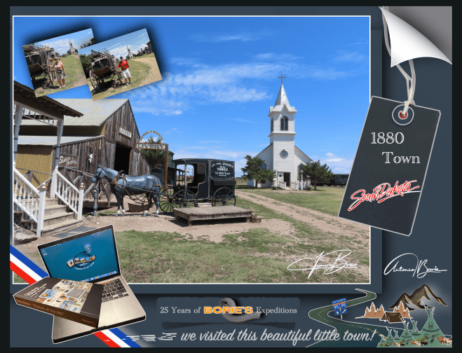
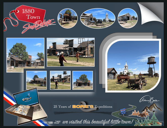
…estávamos no estado de Dakota do Sul, bem situado no coração dos USA, um lugar histórico, uma verdadeira “jóia do oeste”, bem conhecido por essa distinção, que para nós, é o lar de algumas das histórias mais coloridas que podemos encontrar no oeste americano, pelo menos para quem não adora apenas uma boa história de pioneiros ou de sobrevivência!. Porquê?.
…we were in the state of South Dakota, well situated in the heart of the USA, a historical place, a true“west jewel”,well known for this distinction, which for us is the home of some of the most colorful stories we can find in the West American, at least for those who don’t just love a good story of pioneers or survival!. Why?.
…porque além de outras razões, Dakota do Sul está marcado para sempre pela exploração precoce de “Lewis e Clark”, dos anos selvagens da corrida ao ouro na década de 1870 ou pela determinação e espírito dos primeiros pioneiros, que como milhares de outros, escolheram por aqui se estabelecer e desenvolver a terra para o bem do país e da expansão dos seus territórios!.
…because in addition to other reasons, South Dakotais forever marked by the early exploitation of “Lewis and Clark”,the wild years of the Gold Running in the 1870s or the determination and spirit of the first pioneers, which like thousands of others, chose here to establish and develop the land for the good of the country and the expansion of their territories!.
…e, numa rota à volta da estrada rápida #90, que nos havia de levar para Oeste, eis-nos num perfeito ambiente do “Oeste Americano”, com “teatro de rua ao vivo” e tudo!. O lugar, no meio de uma planície deserta, dava pelo nome de “1880 Town”!. Aqui, “os bandidos assaltavam o banco, levando os sacos de ouro, matavam o xerife e os seus ajudantes, aparecendo depois três raparigas bonitas, que por sua vez matavam os bandidos e fugiam em cavalos brancos, com os sacos do ouro!.” Era uma perfeita cena de ”roubar o ouro aos bandidos”!.
…and, on a route around the fast road #90, which would take us west, we found ourselves in a perfect “American West” environment, with “live street theater”and everything!. The place, in the middle of a desert plain, was called “1880 Town”! Here, “the bandits robbed the bank, taking the bags of gold, killed the sheriff and his assistants, and then three beautiful girls appeared, who in turn killed the bandits and fled on white horses, with the bags of gold!.” It was a perfect scene of “stealing the gold from the bandits”!
…e a história diz-nos que naquela época, uma empresa de cinema chegou a uma pequena cidade próxima para filmar um filme da era de 1880!. Um conjunto de “rua principal” foi construído a partir de edifícios antigos e várias relíquias e antiguidades indianas!. O inverno instalou-se, as filmagens foram abandonadas e a empresa de cinema voltou para casa, dando a ”Main Street Set” a alguém para o uso dos seus artefactos!. Anos depois, todo este ”set de filmagem”, foi transferido para estes 80 acres e a cidade de 1880 nasceu!.
…and the story tells us that at that time, a movie company came to a small nearby town to film a 1880!. A set of “main street” was built from old buildings and various relics and Indian antiques!. Winter has settled, filming was abandoned and the movie company returned home, giving the “Main Street Set”to someone to use their artifacts!. Years later, all this “set of footage”was transferred to these 80 acres and the city of 1880 was born!.
…nesta aventura rumo ao norte, não seguimos o mapa do tesouro, do pirata da perna de pau, do papagaio falante, seguimos sim, um mapa moderno, na esperança de ver o cenário que os nossos avós viveram naqueles anos distantes, em que se aventuraram na pesca do peixe bacalhau, lá na gelada região da Terra Nova e do Labrador, Canada!.
…in this adventure heading north, we don’t follow the treasure map, the peg-legged pirate, the talking parrot, we follow a modern map, hoping to see the scenery that our grandparents lived in those distant years, when they ventured out fishing for cod fish, there in the freezing region ofNewfoundland and Labrador, Canada!.
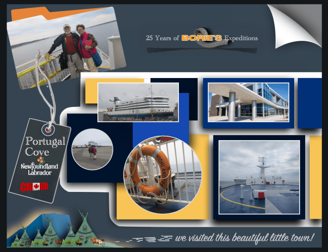
…e, embarcando no navio Highlanders, na cidade portuária de Sydney, na Ilha Cape Breton, na província de Nova Escócia, que é uma das províncias marítimas do leste do Canadá no Oceano Atlântico, parecia que navegámos tal como qualquer famoso pirata das histórias, que viveram durante a Era de Ouro da Pirataria, sobre as águas do Golfo de São Lourenço, que é a saída dos Grandes Lagos da América do Norte através do Rio São Lourenço para o Oceano Atlântico!.
…and, boarding the ship Highlanders,in the port city of Sydney, on Cape Breton Island, in the province of Nova Scotia, which is one of the maritime provinces of eastern Canadain the Atlantic Ocean, it seemed that we sailed just like any famous pirate in history, who lived during the Golden Age of Piracy, over the waters of the Gulf of Saint Lawrence, which is the exit of the Great Lakes of North America through the Saint Lawrence River into the Atlantic Ocean!.
…nós no 9.º andar e a nossa “White Fox” (caravana) no 3.º andar daquele navio que, derivado ao nevoeiro no canal, apitava periodicamente um som forte e lento, não sabemos se arrogante ou de súplica, mas o certo é que, muitas, mesmo muitas horas depois, o nevoeiro ia desaparecendo e já havia terra à vista!.
…we were on the 9th floor and our “White Fox” (caravan) on the 3rd floor of that ship which, due to the fog in the channel, periodically beeped a strong and slow sound, we don’t know if it was arrogant or pleading, but the truth is that, many, even many hours later, the fog was disappearing and land was already in sight!.
…estávamos no porto de Channel-Port aux Basques, cujo cenário nos fazia lembrar as tais aldeias que eram saqueadas pelos já referidos piratas!. No entanto não, não vimos nenhuma dessas personagens, com uma perna de pau, correndo aos saltos, atrás de alguma jovem aldeã, levando uma grande espada numa mão e na outra uma extravagante garrafa de qualquer licor, que normalmente era “rum” de fraca qualidade!.
…we were in the port of Channel-Port aux Basques,whose scenery reminded us of the villages that were plundered by the aforementioned pirates!. However, no, we didn’t see any of these characters, with one peg leg, running in leaps and bounds, after some young village girl, carrying a large sword in one hand and in the other an extravagant bottle of some kind of liquor, which was usually low-quality “rum”!
…o desembarque foi feito normalmente, saindo para terra, conduzindo a nossa “White Fox” (caravana)!. Finalmente estávamos na província de Terra Nova e Labrador, que é a província mais oriental do Canadá, situada na região atlântica do país, que compreende a ilha de Terra Nova e o continente de Labrador a noroeste e…, no nosso percurso, fomos parando aqui e ali, apreciando um cenário de pequenas aldeias piscatórias, muito parecido com os cenários que normalmente vimos nos parques ou filmes do Walt Disney!.
…the disembarkation was done normally, leaving for land, driving our “White Fox” (caravan)!. Finally we were in the province of Newfoundland and Labrador,which is the easternmost province of Canada,located in the Atlantic region of the country, which comprises the island of Newfoundland and the continent of Labrador to the northwest and…, on our route, we stopped here and there, enjoying a scenery of small fishing villages, very similar to the scenes we normally saw in Walt Disney parks or films!.
…e bendizendo a oportunidade de poder visitar esta província, onde se podia apreciar um estilo de vida documental, diferente, levando para aqui espectadores dos quatro cantos do nosso planeta, para descobrir e aprender sobre todos os tipos de peixes exóticos e misteriosos, culturas, num cenário com belas paisagens e pessoas diferentes, que abrem as portas para suas vidas e compartilham as suas histórias com os visitantes!.
…and blessing the opportunity to visit this province, where one could enjoy a different, documentary lifestyle, taking viewers from the four corners of our planet here, to discover and learn about all types of exotic and mysterious fish, cultures, in a setting with beautiful landscapes and different people, who open the doors to their lives and share their stories with visitors!.
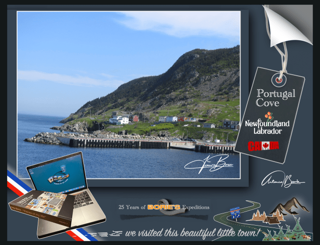
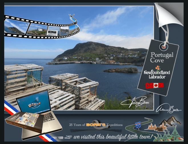
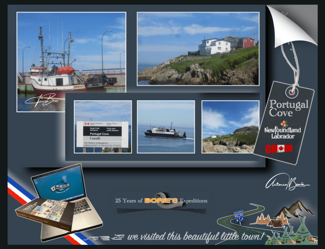
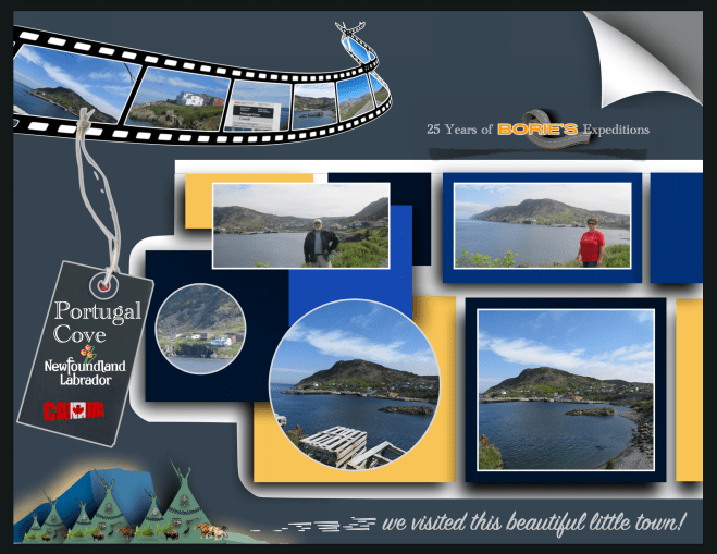
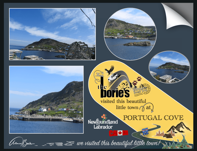
…íamos percorrendo o nosso percurso, até que chegamos à área da aldeia de “Portugal Cove”, que é uma comunidade de litoral rural, localizada na Baía de Concepção, sendo o local de um terminal de pequenos navios que fornece acesso diário de e para a Ilha de Bel, e nós e…, nunca esquecendo a relação dos portugueses com a Terra Nova, que é secular e carrega consigo muitas memórias de aventuras da faina da pesca do bacalhau, pois a história diz-nos que estas terras nunca foram colonizadas por Portugal, apesar das várias viagens de exploração realizadas a estes águas e territórios, talvez impedidos por corsários de outras nações com maior potência militar!.
…we were following our route, until we arrived at the area of the village of “Portugal Cove”,which is a rural coastal community, located in Conceição Bay,being the location of a small ship terminal that provides daily access to and from Bel Island,and we and…, never forgetting the Portuguese relationship with Newfoundland,which is centuries old and carries with it many memories of adventures in cod fishing, as history tells us that these lands were never colonized by Portugal, despite several exploration trips made to these waters and territories, perhaps prevented by privateers from other nations with greater military power!.
…e também sendo nós oriundos de Portugal, parámos para visitar com mais pormenor esta aldeia que dá pelo nome de “Portugal Cove”!. Sim “Portugal Cove” e porquê este nome?. Talvez porque no século XV ou princípios do século XVI, os portugueses daquele tempo, chamavam mesmo à área da Terra Nova, a Terra dos Bacalhaus ou Terra dos Corte Reais!. Mais tarde, por volta dos anos de 1850, em Portugal, uma empreza da cidade de Lisboa chegou a mandar para os bancos pesqueiros da Terra Nova, 19 veleiros, com um total de aproximadamente 325 homens!.
…and also as we come from Portugal, we stopped to visit in more detail this village called “Portugal Cove”!.Yes “Portugal Cove”and why this name?. Maybe because in the 15th century or early 16th century, the Portuguese at that time even called the Terra Nova area the Land of Bacalhaus or Land of Corte Reais!. Later, around the 1850s, inPortugal,a company from the city of Lisbon sent 19 sailboats to the fishing banks of Newfoundland, with a total of approximately 325 men!.
…andámos por aqui e falando com alguns habitantes, ficavam admirados ao dizermos que éramos de descendência portuguesa e iam descrevendo aquilo que sabiam, que o lema da aldeia é “onde o sol encontra o mar’!. Este lema é irónico, já que devido ao posicionamento da Ilha de Bell, na baía, o sol poente nunca encontra o mar a qualquer momento, mas é o seu lema, vai lá saber-se porquê!.
…we walked around and spoke to some inhabitants, they were surprised when we said that we were of Portuguese descent and they described what they knew, that the village’s motto is “where the sun meets the sea”! This motto is ironic, since due to the positioning of Bell Island,in the bay, the setting sun never meets the sea at any time, but it is their motto, let’s find out why!.
…também nos disseram que “Portugal Cove” é uma comunidade onde existem pequenas quintas, lojas de conveniência, restaurantes ou cafés, lojas de artigos de construção, centros de jardinagem, salões de beleza, garagens e estações de serviço, um serviço de táxi e algumas casas que dão dormida e pequeno almoço, o que já não é pouco!.
…we were also told that “Portugal Cove” is a community where there are small farms, convenience stores, restaurants or cafes, home improvement stores, garden centers, beauty salons, garages and service stations, a taxi service and some houses that provide overnight accommodation and breakfast, which is no small feat!
…na história, a comunidade é uma das mais antigas da Terra Nova, com uma história muito rica, fundada pelos portugueses e, foi uma das primeiras aldeias estabelecidas no novo mundo!. Tem sido históricamente católica romana, sendo servida pela Igreja do Santo Rosário!. Foi o local da primeira estrada construída fora da capital St. John’s!.
…in history, the community is one of the oldest in Newfoundland,with a very rich history, founded by the Portuguese and was one of the first villages established in the new world!. It has historically been Roman Catholic, being served by theChurch of the Holy Rosary!. It was the site of the first road built outside the capital St. John’s!.
…a hoje Enseada de Portugal, tem um grande corpo de tradições folclóricas, pois dizem-nos que a área, já habitada, foi atacada e queimada pelos franceses, no distante ano de 1697 e, foi aqui que a lenda da Lula Gigante ou Kraken, (legendário monstro do mar, parecendo a figura de uma lula gigante), foi descoberta e documentada!. Depois, o nome de Enseada de Portugal, foi dado pelos pescadores Portugueses, por volta do século 17, no entanto outros povos por aqui viveram como pescadores oriundos do oeste da Inglaterra, da Irlanda ou das Ilhas do Canal, como por exemplo Jersey!.
…today Cove of Portugal,has a large body of folklore traditions, as we are told that the area, already inhabited, was attacked and burned by the French, in the distant year of 1697 and, it was here that the legend of the Giant Squid or Kraken, (legendary sea monster, resembling the figure of a giant squid), was discovered and documented!. Afterwards, the name Portugal Cove was given by Portuguese fishermen, around the 17th century, however other people here lived as fishermen from the west of England, Ireland or the Channel Islands, such as Jersey!.
…e também nos informaram que existe outro local com o nome de Enseada de Portugal do Sul, que posteriormente visitámos!. Uma curiosidade, quando pronunciam o nome Portugal, dizem com sotaque de voz em Português!.
…and they also informed us that there is another place called South Portugal Cove, which we later visited!. Interestingly, when they pronounce the name Portugal,they say it with an accent in Portuguese!
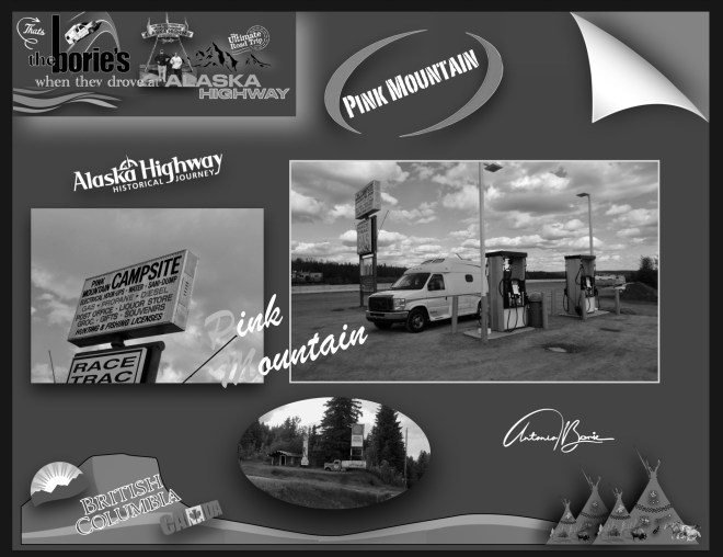
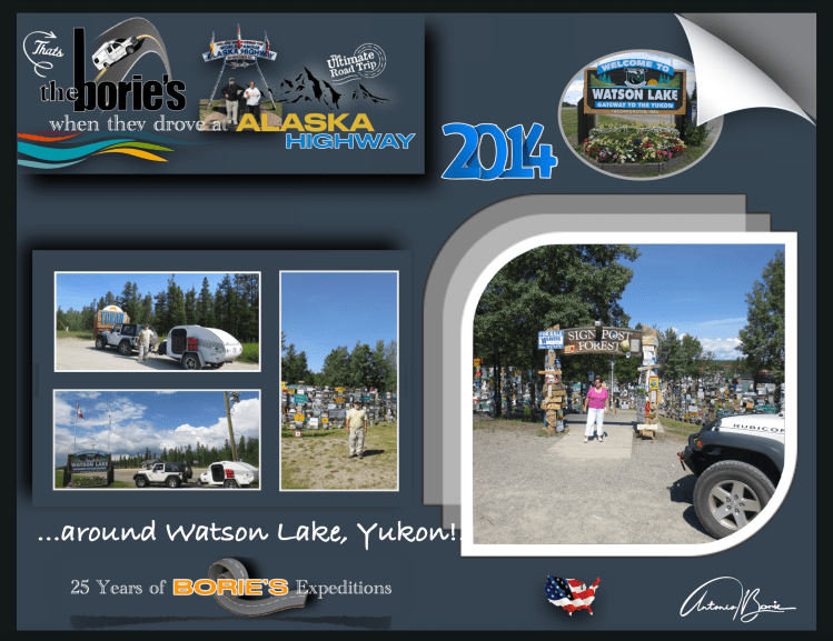
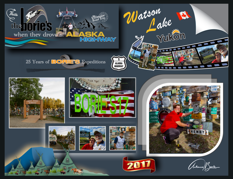
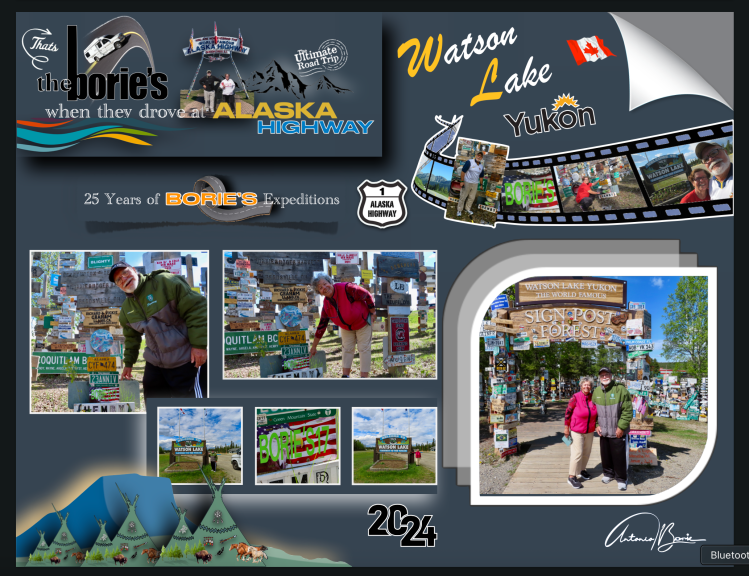
…é a milha 635 e chegámos à cidade Watson Lake, que é uma cidade situada na província do Yukon, um território no noroeste do Canadá, que é selvagem, montanhoso e pouco povoado e onde um caçador e prospector de origem americana, se instalou nesta área no final do século XIX!.
…it’s mile 635 and we arrived at the city of Watson Lake,which is a city located in the province of Yukon,a territory in the northwest of Canada,which is wild, mountainous and sparsely populated and where a hunter and prospector of American origin settled in this area at the end of the 19th century!.
…no entanto hoje, além de ser é um pequeno centro de indústria madeireira, também tem sido um centro de serviços para o sector de mineração onde existem alguns restaurantes, estações de abastecimento de gasolina e uma loja de venda de alguns géneros de primeira necessidade para quem viaja!. Aqui, fomos ver uma placa que assinalava uma nossa passagem, pois já por aqui tínhamos parado e até pernoitado por diversas vezes!.
…however today, in addition to being a small center for the timber industry, it has also been a service center for the mining sector where there are some restaurants, gasoline filling stations and a store selling some basic necessities for those who travel!. Here, we went to see a sign that marked our passage, as we had already stopped here and even stayed the night several times!
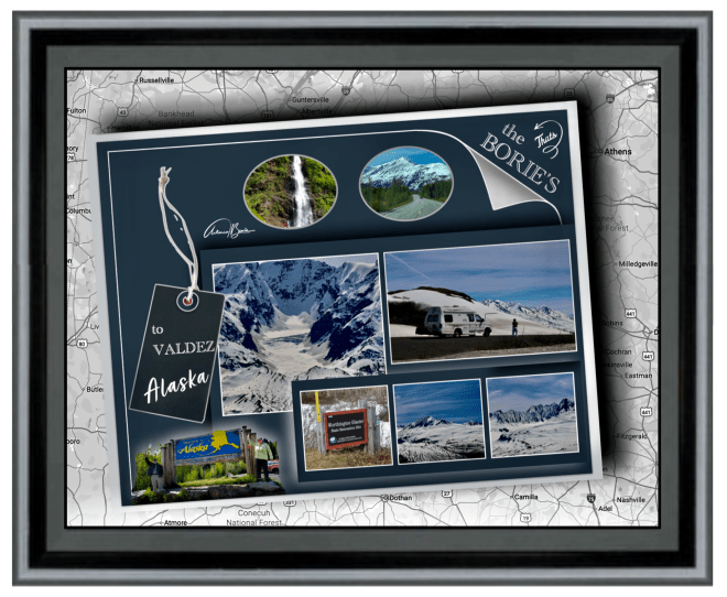
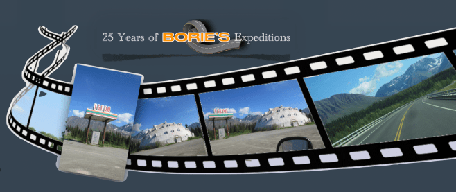
…é um local situado na região norte da hoje legendária “Histórica Estrada do Alaska”!. Era a aventura e…, também uma homenagem às pessoas dedicadas e trabalhadoras que com muito trabalho físico, onde era usada a pá, a picareta e a vagoneta, trabalhando muitas horas seguidas, nas mínimas condições de segurança, construíram esta estrada, durante a “World War II”, com o propósito de haver uma via de comunicação terrestre entre o continente dos USA e o estado do Alaska, claro, passando pelo território do Canadá!.
…it is a place located in the northern region of the now legendary “Historic Alaska Highway”!.It was adventure and…, also a tribute to the dedicated and hard-working people who, with a lot of physical work, using shovels, pickaxes and carts, working many hours at a time, in the minimum safety conditions, built this road, during “World War II”, with the purpose of having a land communication route between the mainland of the USA and the state of Alaska, of course, passing through the territory of Canada!.
…porquê?. Porque havia notícias que o Japão queria invadir “Kiska Island” (Ilha de Kiska) e “Attu Island” (Ilha de Attu), na região das “Aleutians Islands” (Ilhas de Aleutians), e claro, tudo tinha que ficar completo antes que chegasse o inverno!.
…why?. Because there was news that Japan wanted to invade “Kiska Island” and “Attu Island”, in the region of the “Aleutians Islands”, and of course, everything had to be completed before winter arrived!.
…mencionando algumas curiosidades desta hoje “Histórica Estrada do Alaska”,, não existe em todo o seu percurso um único túnel, tudo foi feito à pressa, à luz do dia, sempre improvisando, com os recursos que naquela ocasião existiam, fazendo todas as curvas, que o acidentado do terreno mostrava!. Em algumas zonas, não sendo possível seguir, rasgavam o lado das montanhas, de onde tiravam terra, cascalho ou pedra, para colocar em alguns terrenos mais baixos, que eram alagadiços!.
…mentioning some curiosities of today’s “Historic Alaska Highway”,there is not a single tunnel along its entire route, everything was done in a hurry, in daylight, always improvising, with the resources that existed at that time, making all the curves, which the rugged terrain showed!. In some areas, when it was not possible to follow, they tore up the side of the mountains, where they took earth, gravel or stone, to place in some lower terrain, which was swampy!.
…e, uma dessas dedicadas pessoas, um soldado do Exército dos USA que se encontrava doente e trabalhava na construção desta hoje famosa “Histórica Estrada do Alaska”, com saudades da sua cidade natal, colocou um sinal com o nome de sua cidade natal e a distância!.
…and, one of these dedicated people, a US Army soldier who was ill and worked on the construction of this now famous “Historic Alaska Highway”, missing his hometown, placed a sign with the name of his hometown and the distance!.
…foi o início para que outros, entre os quais nos inserimos, seguindo o seu exemplo, vindo das mais remotas partes do mundo, continuaram a tradição, onde hoje, neste local designado como uma atracção turística pelo nome de “Signpost Forest”, e que foi iniciado no ano de 1942, já lá existem mais de oito milhares de sinais de vários tipos que retratam locais em todo o mundo, e onde nós também lá deixámos uma placa com o nosso nome e data, no ano de 2017, assinalando uma das nossas passagens!.
…it was the beginning for others, among whom we are included, following their example, coming from the most remote parts of the world, to continue the tradition, where today, in this place designated as a tourist attraction by the name of “Signpost Forest”, and which was started in 1942, there are already more than eight thousand signs of various types that depict places around the world, and where we also left a plaque there with our name and date, in 2017, marking one of our passages!
…uma curiosidade, é que a placa colocada por nós há aproximadamente oito anos, estava intacta, sobrevivendo a todos estes anos de neve, chuva, sol ou frio!.
…a curious fact is that the plaque we placed approximately eight years ago was intact, surviving all these years of snow, rain, sun or cold!
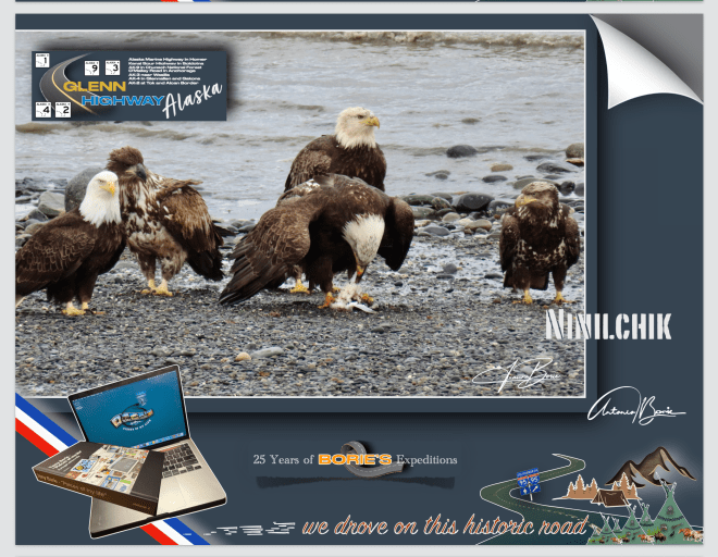
…era numa manhã onde o tempo nem era quente nem frio, era…, “lusco-fusco”, onde algumas águias pescavam nas ondas da praia desta pequena vila de Ninilchik, situada na Península de Kenai, que para nós é um lugar muito especial, porque além de outras coisas, um dialeto russo e raro, que deve de ser uma fusão da língua russa, inglês e línguas indígenas, que nos dão um exemplo sonoro do legado multicultural desta pequena vila, e ainda é lá falado!.
…it was on a morning where the weather was neither hot nor cold, it was…, “twilight”, where some eagles were fishing in the waves on the beach of this small village of Ninilchik,located on theKenai Peninsula,which for us is a very special place, because among other things, a rare Russian dialect, which must be a fusion of the Russian language, English and indigenous languages, which gives us a sound example of the multicultural legacy of this small village, and is still spoken there!.
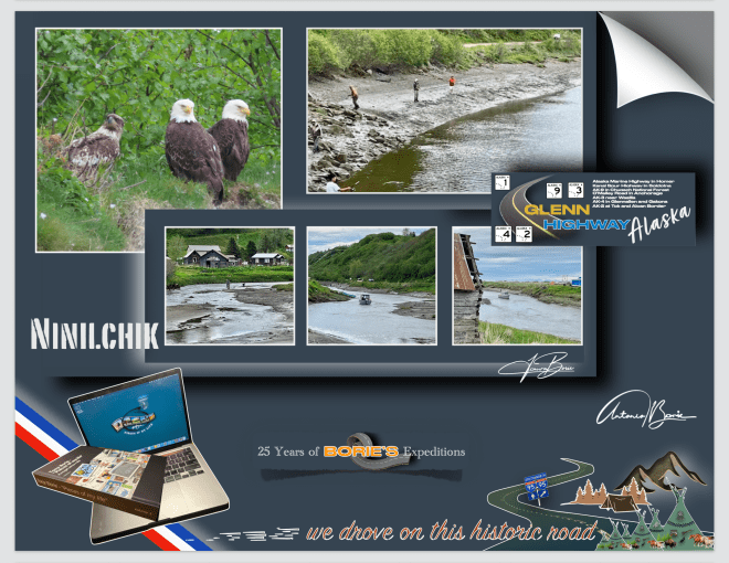
…não era a primeira vez que lá parávamos, já de outras expedições visitámos este lugar porque fica ao lado da única estrada que nos leva para sul ao longo da Península de Kenai, onde na sua história cultural faz parte a Igreja Ortodoxa Russa de Ninilchik, que é um ponto central, mesclando a liturgia antiga com as tradições da região, onde no seu cemitério histórico revela histórias dos primeiros colonizadores, com lápides marcadas em alfabeto cirílico!.
…it wasn’t the first time we stopped there, we’ve visited this place on other expeditions because it’s next to the only road that takes us south along the Kenai Peninsula,where its cultural history includes the Russian Orthodox Church of Ninilchik, which is a central point, mixing the ancient liturgy with the traditions of the region, where its historic cemetery reveals stories of the first settlers, with tombstones marked in the Cyrillic alphabet!.
…esta pequena vila foi fundada por volta do ano de 1847, tornando-se um refúgio para funcionários aposentados da Companhia Russo-Americana e suas famílias, que optaram por integrar os seus costumes russos ao modo de vida local e hoje, fazendo de Ninilchik um museu vivo dessa síntese cultural única, estando repleta de construções históricas de madeira em estilo russo que dominam a paisagem, simbolizando a alma russa que perdura em Ninilchik!.
…this small village was founded around 1847, becoming a refuge for retired employees of the Russian-American Company and their families, who chose to integrate their Russian customs into the local way of life and today, making Ninilchik a living museum of this unique cultural synthesis, being full of historic Russian-style wooden buildings that dominate the landscape, symbolizing the Russian soul that endures in Ninilchik!.
…caminhar por aqui é como voltar ao estilo de vida de subsistência que os primeiros colonizadores, incluindo os comerciantes de peles russos, teriam vivido neste terreno acidentado no início do século XIX!. Este cenário pitoresco, com as suas robustas casas de pescadores, em madeira, pintam um retrato vívido das suas origens!. Barcos de pesca encalhados aqui e ali, contribuem para o charme e a autenticidade desta pequena vila, refletindo uma mistura de história e natureza, onde os visitantes tal como nós, caminhando ao longo do Rio Ninilchik, podem admirar lá ao cimo o Mirante Panorâmico de Ninilchik, desfrutando também de muitas oportunidades incomparáveis para pesca ou coleta de mariscos!.
…walking here is like returning to the subsistence lifestyle that early settlers, including Russian fur traders, would have lived in this rugged terrain in the early 19th century!. This picturesque setting, with its robust wooden fishermen’s houses, paints a vivid portrait of its origins!. Fishing boats stranded here and there contribute to the charm and authenticity of this small village, reflecting a mix of history and nature, where visitors like us, walking along theNinilchik River,can admire the Ninilchik Panoramic Viewpointfrom above, also enjoying many incomparable opportunities for fishing or shellfish gathering!.
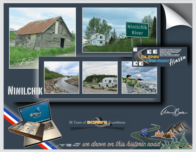
…não sabemos se viveremos o suficiente para poder voltar a esta maravilhosa e pequena vila de Ninilchik, mas a verdade é que ao a deixar-mos para trás a caminho do norte…, a levámos no coração!.
…we don’t know if we will live long enough to be able to return to this wonderful little village of Ninilchik, but the truth is that when we left it behind on our way to the north…, we took it in our hearts!.
…saímos da cidade de Fairbanks pela manhã e viajávamos no sentido sul pela estrada “GeorgeParks Highway”!. Aproximadamente a 22 milhas ao sul da pequena cidade de Cantwell, sentimos alguma desilusão ao ver um edifício com estas linhas de construção, representando o célebre “Igloo”, que quando crianças, sempre via-mos nas histórias dos “livros aos quadradinhos, e quando se referiam ao Polo Norte”, que está fechado, abandonado e em princípio de ruínas!.
…we left the city of Fairbanksin the morning and traveled south along the “George Parks Highway”!. Approximately 22 miles south of the small town of Cantwell,we felt some disappointment when we saw a building with these construction lines, representing the famous “Igloo”,which as children, we always saw in stories in “square books, and when they referred to the North Pole”, which is closed, abandoned and in principle ruins!.!.
…o lugar é conhecido como “Igloo City”, e este “Igloo”, cuja construção foi iniciada na década de 1970, nunca foi concluído como um hotel, devido a problemas financeiros e códigos de construção!. A sua estrutura em forma de cúpula de vários andares, fica ao lado do já acima referido “George Parks Highway” e hoje, tornou-se um marco para exploradores urbanos e turistas, apesar do seu estado de degradação, devido ao clima e algum vandalismo!.
…the place is known as “Igloo City”,and this“Igloo”,whose construction began in the 1970s, was never completed as a hotel, due to financial problems and building codes!. Its multi-story dome-shaped structure is next to the aforementioned “George Parks Highway”and today, it has become a landmark for urban explorers and tourists, despite its state of degradation, due to the weather and some vandalism!.
…está dentro de uma propriedade privada, com acesso restrito, habitada por alguns ursos e outros animais, e a seu lado norte, também lá está um posto de gasolina abandonado, um enorme estacionamento de cascalho, algumas cabanas fechadas e um banheiro externo!. Tudo isto num terreno de 38 acres e sem eletricidade, situado ao longo de um trecho de estrada muito bonito e onde se podem ver montanhas ainda com alguma neve no seu pico, mas…, no meio de nada, neste estado do Alaska!.
…it is inside a private property, with restricted access, inhabited by some bears and other animals, and on its north side, there is also an abandoned gas station, a huge gravel parking lot, some closed cabins and an external bathroom!. All this on a 38-acre plot of land without electricity, located along a very beautiful stretch of road and where you can see mountains with some snow still on their peaks, but…, in the middle of nowhere, in this state of Alaska!.
…nas nossas três expedições ao estado do Alaska, sempre parámos para apreciar esta estrutura de 25 metros de altura e 30 metros de largura, que à distância parece ser uma cúpula de concreto repleta de janelas, até que chegamos perto o suficiente e poder ver o seu esqueleto salpicado de grafites, tornando-se numa estranheza americana de primeira linha, onde os viajantes, tal como nós, que viajam pela solitária “George Parks Highway”, entre Fairbanks e Anchorage, passam de carro ou caravana, e simplesmente ficam boquiabertos, às vezes parando para tirar selfies ou fazer o seu xixi, antes de seguir em frente!.
…on our three expeditions to the state of Alaska, we always stopped to appreciate this 25 meter high and 30 meter wide structure, which from a distance appears to be a concrete dome full of windows, until we get close enough to see its skeleton dotted with graffiti, becoming a first-class American oddity, where travelers, like us, who travel the lonely “George Parks Highway”,between Fairbanksand Anchorage,pass by car or caravan, and simply gawk, sometimes stopping to take selfies or pee, before moving on!.
…para nós, este “Igloo”, tornou-se uma presença marcante e estranhamente amada na paisagem do Alaska e…, ao aprecia-lo, sem qualquer dúvida que nos faz renascer a apreciação que temos por este 49º estado, e claro, é um lugar que nós visitantes lembramos com carinho, tal qual como o vizinho Parque Nacional Denali!.
…for us, this “Igloo”,has become a striking and strangely loved presence in the Alaskan landscape and…, when appreciating it, without any doubt it makes us reborn the appreciation we have for this 49th state, and of course, it is a place that we visitors remember fondly, just like the neighboring Denali National Park!.