…seguíamos em direcção ao leste, pela estrada número 1, a que também chamam Trans-Canada Highway, passando por alguns lugares onde existiam sinais de trânsito indicando saídas para algumas cidades, vilas ou aldeias, como por exemplo, Twillingate ou para as Ilhas do Fogo e da Mudança, mais ao norte, que estavam no nosso roteiro, mas que a recomendação no Centro de Visitantes nos preveniu de não era aconselhável viajar para lá, pelo menos com o equipamento que levávamos!.
…we headed east, along road number 1, which we also call the Trans-Canada Highway,passing through some places where there were traffic signs preventing exits to some cities, towns or villages, such as Twillingateor the Islands of Fireand Change, further north, which we included in our itinerary, but the recommendation at the Visitor Center warned us that it was not advisable to travel there, at least with the equipment we took!.
…o dia já ia avançado e, às vezes parecia que viajávamos noutro planeta onde já se começava a ver um pôr do sol dourado que tornava o cenário de pequenas montanhas douradas reflectidas sobre a água de pequenos lagos e riachos, onde o silêncio se estendia por milhas e milhas e…, a nossa dedicada esposa Isaura, procurava na internet um parque de RV para pernoitarmos, que com alguma sorte encontrámos e…, era um local com história!.
…the day was already advanced and, at times, it seemed as if we were traveling through another planet where we were beginning to see a golden sunset that made the scene of small golden mountains reflected on the water of small lakes and streams, where silence stretched for miles and miles and…, our dedicated wife Isaura,was looking online for an RV park for us to spend the night, which with some luck we found and…, it was a place with history!.
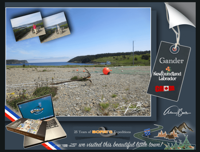
…era a cidade de Gander, na província da Terra Nova no Canadá, que já estava acostumada a receber visitantes internacionais, pois afinal, esta cidade foi construída em torno do seu aeroporto, podendo mesmo dizer-se que “Gander existe por causa de seu aeroporto”, que foi escolhido pela sua localização estratégica nesta ilha oriental do Canadá!.
…it was the city of Gander, in the province of Newfoundland in Canada,which was already used to receiving international visitors, as after all, this city was built around its airport, and it could even be said that “Gander exists because of its airport”, which was discovered due to its strategic location on this eastern island in Canada!.
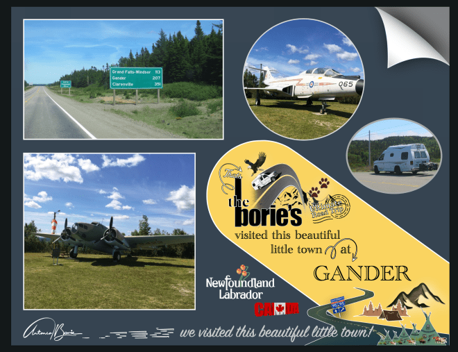
…onde a amável pessoa que nos atendeu, explicando toda a história, logo nos foi dizendo: “óhóoo…, vêm dos USA, tiveram sorte em pernoitar por aqui, pois o nosso generoso e abenegado povo, por ocasião do horrível dia em que o World Trade Center, na cidade de Nova Iorque, foi destruído por um horroroso ataque terrorista, assim como parte do Pentágono, na cidade de Washington e, quase 3.000 pessoas morreram, o nosso Aeroporto Internacional de Gander, recebeu centenas de aeronaves, que transportavam milhares de passageiros e foram obrigadas a pousar”!
…where the kind person who attended to us, explaining the whole story, soon told us: “ohhóoo…, they come from the USA, they were lucky to spend the night here, because our generous and selfless people, on the occasion of the horrible day in which the World Trade Center, in the city of New York, was destroyed by a horrible terrorist attack, as well as part of the Pentagon, in the city of Washington and, almost 3,000 people died, our Gander International Airport, received hundreds of aircraft, which were carrying thousands of passengers and were forced to land”!.
…e continuou: “qualquer um dos aviões no ar naquela manhã de 11 de setembro de 2001, poderia ter sido outro míssil de morte!. Quem sabia quão grande era esse ataque terrorista?. Quando os EUA fecharam seu espaço aéreo, aqui, o nosso pequeno Aeroporto Internacional Gander, na Terra Nova, abriu as suas pistas, onde aterraram 38 aviões de fuselagem larga em rotas transatlânticas”!.
…and continued:“any of the planes in the air that morning of September 11, 2001, could have been another missile of death!. Who knew how big this terrorist attack was?. When the USA closed its airspace, here, our small Gander International Airport, in Newfoundland, opened its runways, where 38 wide-body planes landed on transatlantic routes”!.
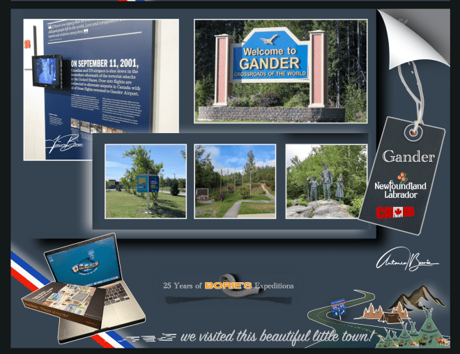
…claro, esta amável pessoa, contou-nos mais uma das muitas histórias do horrível 11 de Setembro, onde as pessoas da cidade de Gander, que não eram mais de 10.000, naqueles dias olhavam para todos os aviões alinhados no aeroporto e não falavam em terrorismo, não viam ataques potenciais!. Eles só queriam ajudar!.
…of course, this kind person told us one of the many stories of the horrible September 11th, where the people of the city of Gander, who were no more than 10,000, in those days looked at all the planes lined up at the airport and didn’t talk about terrorism, they didn’t see potential attacks!. They just wanted to help!
…esta cidade, todos os anos, por ocasião do dia 11 de Setembro, lembra os USA, do mal que ninguém conseguiu deter e que infelizmente se alastrou por todo o mundo!. Também nos devemos lembrar da capacidade humana de bondade, abnegação e generosidade que estas pessoas da cidade de Gander e áreas vizinhas tiveram, atravessando magnificamente a crise, respondendo a anúncios de rádio, oferecendo comida, medicamentos, sabonetes, cobertores e até roupas interiores extras, além de ofertas de chuveiros quentes e quartos de hóspedes a todos os 6.579 passageiros e tripulantes das aeronaves!.
…this city, every year, on the occasion of September 11th, reminds the USA of the evil that no one was able to stop and that unfortunately spread throughout the world!. We must also remember the human capacity for kindness, selflessness and generosity that these people of the city of Gander and neighboring areas had, magnificently going through the crisis, responding to radio advertisements, offering food, medicines, soaps, blankets and even extra underwear, in addition to offering hot showers and guest rooms to all 6,579 passengers and crew of the aircraft!.
…onde uma pequena comunidade no meio de uma ilha relativamente isolada no Atlântico Norte, estando muito exposta ao resto do mundo, provavelmente os ajudou a prepararem-se para o que aconteceu em Setembro de 2001, onde revelaram a sua compaixão global integrada na cultura desta comunidade, ficando claro que os passageiros retidos, “pessoas do avião”, como os moradores locais os apelidaram carinhosamente, ficariam lá por dias, que acabaram sendo liberados dos aviões, alguns depois de quase 24 horas numa aeronave paralisada!.
…where a small community in the middle of a relatively isolated island in the North Atlantic, being very exposed to the rest of the world, probably helped them prepare for what happened in September 2001, where they revealed their global compassion integrated into the culture of this community, making it clear that the stranded passengers,“plane people”, as the locals affectionately called them, would be there for days, that they ended up being released from the planes, some after almost 24 hours in a grounded aircraft!.
…sem hesitar, os “Newfoundlanders”, tal como acima já explicámos, abriram as suas casas para que tomassem banho, suas academias escolares, centros comunitários e hotéis para deixá-los dormir e comer refeições quentes; e os seus corações para o desconhecido, após uma tragédia de tal magnitude!.
…without hesitation, the“Newfoundlanders”,as we explained above, opened their homes to bathe, their school gyms, community centers and hotels to let them sleep and eat hot meals; and their hearts towards the unknown, after a tragedy of such magnitude!.
…estas pessoas fizeram tudo isto sem quaisquer instruções, foi algo que realmente veio naturalmente, apenas o fizeram, recebendo em suas casas pessoas estranhas, colocando todos em pé de igualdade de condições, ou seja, ”todas as religiões, todas as políticas, tudo o que fosse, estavam a ser tratadas exactamente da mesma forma”, onde quase 100 nacionalidades representadas, tiveram que comer as comidas mais loucas, onde sobressaiam os favoritos locais, como ensopado de alce e coelho!. Enfim, ”todos estavam sendo alimentados com o mesmo tipo de comida, onde uma pessoa poderia ser milionário e a outra pessoa ao lado poderia estar sem um centavo no bolso, não importava, nesta situação, eram todas iguais”!.
…these people did all this without any instructions, it was something that really came naturally, they just did it, welcoming strange people into their homes, putting everyone on an equal footing, that is, “all religions, all politics, whatever, were being treated exactly the same way”,where almost 100 nationalities represented, had to eat the craziest foods, where local favorites stood out, such as elk and rabbit stew!. Anyway, “everyone was being fed the same type of food, where one person could be a millionaire and the other person next to them could be without a penny in their pocket, it didn’t matter, in this situation, they were all the same”!
…e, tal como nos lembra o musical da Broadway “Come From Away”, a comunidade canadense de Gander acolheu os 6.579 estranhos no seu ceio, naqueles dias mais sombrios dos USA, onde esta comunidade se tornou “numa Pequena Maçã e não a Grande Maçã”, tal como disse o prefeito da cidade, no ano de 2001!.
…and, as the Broadway musical“Come From Away” reminds us, the Canadian community of Ganderwelcomed 6,579 strangers into its midst, in those darkest days in the USA, where this community became “a Little Apple and not the Big Apple”, as the city’s mayor said in 2001!.
…nesta aventura rumo ao norte, não seguimos o mapa do tesouro, do pirata da perna de pau, do papagaio falante, seguimos sim, um mapa moderno, na esperança de ver o cenário que os nossos avós viveram naqueles anos distantes, em que se aventuraram na pesca do peixe bacalhau, lá na gelada região da Terra Nova e do Labrador, Canada!.
…in this adventure heading north, we don’t follow the treasure map, the peg-legged pirate, the talking parrot, we follow a modern map, hoping to see the scenery that our grandparents lived in those distant years, when they ventured out fishing for cod fish, there in the freezing region ofNewfoundland and Labrador, Canada!.
…e, embarcando no navio Highlanders, na cidade portuária de Sydney, na Ilha Cape Breton, na província de Nova Escócia, que é uma das províncias marítimas do leste do Canadá no Oceano Atlântico, parecia que navegámos tal como qualquer famoso pirata das histórias, que viveram durante a Era de Ouro da Pirataria, sobre as águas do Golfo de São Lourenço, que é a saída dos Grandes Lagos da América do Norte através do Rio São Lourenço para o Oceano Atlântico!.
…and, boarding the ship Highlanders,in the port city of Sydney, on Cape Breton Island, in the province of Nova Scotia, which is one of the maritime provinces of eastern Canadain the Atlantic Ocean, it seemed that we sailed just like any famous pirate in history, who lived during the Golden Age of Piracy, over the waters of the Gulf of Saint Lawrence, which is the exit of the Great Lakes of North America through the Saint Lawrence River into the Atlantic Ocean!.
…nós no 9.º andar e a nossa “White Fox” (caravana) no 3.º andar daquele navio que, derivado ao nevoeiro no canal, apitava periodicamente um som forte e lento, não sabemos se arrogante ou de súplica, mas o certo é que, muitas, mesmo muitas horas depois, o nevoeiro ia desaparecendo e já havia terra à vista!.
…we were on the 9th floor and our “White Fox” (caravan) on the 3rd floor of that ship which, due to the fog in the channel, periodically beeped a strong and slow sound, we don’t know if it was arrogant or pleading, but the truth is that, many, even many hours later, the fog was disappearing and land was already in sight!.
…estávamos no porto de Channel-Port aux Basques, cujo cenário nos fazia lembrar as tais aldeias que eram saqueadas pelos já referidos piratas!. No entanto não, não vimos nenhuma dessas personagens, com uma perna de pau, correndo aos saltos, atrás de alguma jovem aldeã, levando uma grande espada numa mão e na outra uma extravagante garrafa de qualquer licor, que normalmente era “rum” de fraca qualidade!.
…we were in the port of Channel-Port aux Basques,whose scenery reminded us of the villages that were plundered by the aforementioned pirates!. However, no, we didn’t see any of these characters, with one peg leg, running in leaps and bounds, after some young village girl, carrying a large sword in one hand and in the other an extravagant bottle of some kind of liquor, which was usually low-quality “rum”!
…o desembarque foi feito normalmente, saindo para terra, conduzindo a nossa “White Fox” (caravana)!. Finalmente estávamos na província de Terra Nova e Labrador, que é a província mais oriental do Canadá, situada na região atlântica do país, que compreende a ilha de Terra Nova e o continente de Labrador a noroeste e…, no nosso percurso, fomos parando aqui e ali, apreciando um cenário de pequenas aldeias piscatórias, muito parecido com os cenários que normalmente vimos nos parques ou filmes do Walt Disney!.
…the disembarkation was done normally, leaving for land, driving our “White Fox” (caravan)!. Finally we were in the province of Newfoundland and Labrador,which is the easternmost province of Canada,located in the Atlantic region of the country, which comprises the island of Newfoundland and the continent of Labrador to the northwest and…, on our route, we stopped here and there, enjoying a scenery of small fishing villages, very similar to the scenes we normally saw in Walt Disney parks or films!.
…e bendizendo a oportunidade de poder visitar esta província, onde se podia apreciar um estilo de vida documental, diferente, levando para aqui espectadores dos quatro cantos do nosso planeta, para descobrir e aprender sobre todos os tipos de peixes exóticos e misteriosos, culturas, num cenário com belas paisagens e pessoas diferentes, que abrem as portas para suas vidas e compartilham as suas histórias com os visitantes!.
…and blessing the opportunity to visit this province, where one could enjoy a different, documentary lifestyle, taking viewers from the four corners of our planet here, to discover and learn about all types of exotic and mysterious fish, cultures, in a setting with beautiful landscapes and different people, who open the doors to their lives and share their stories with visitors!.
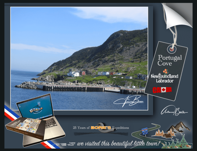
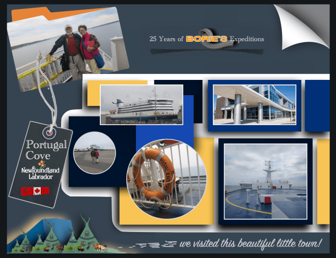
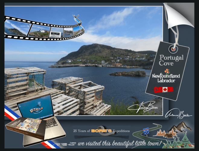
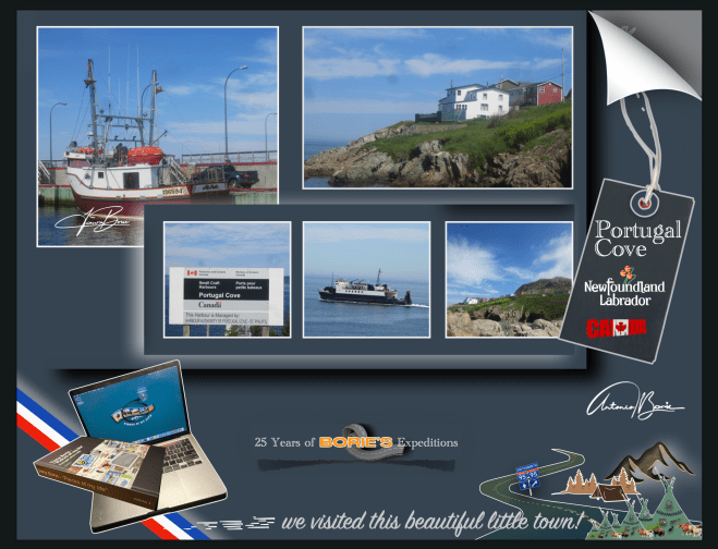
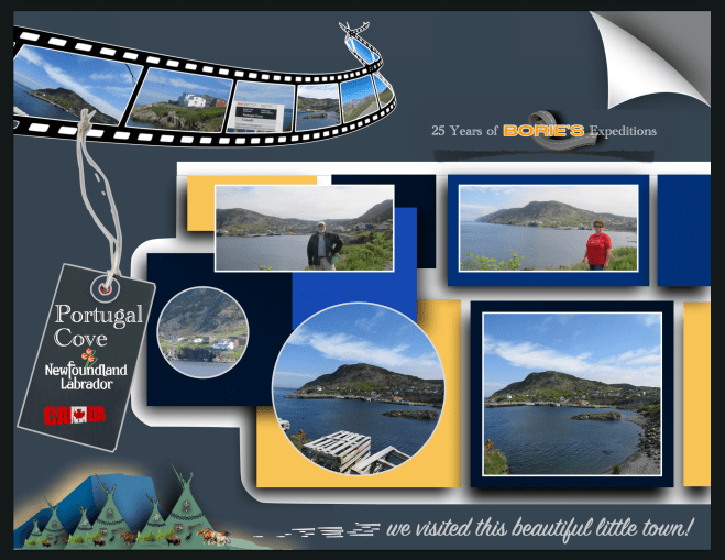
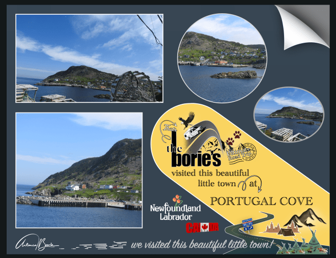
…íamos percorrendo o nosso percurso, até que chegamos à área da aldeia de “Portugal Cove”, que é uma comunidade de litoral rural, localizada na Baía de Concepção, sendo o local de um terminal de pequenos navios que fornece acesso diário de e para a Ilha de Bel, e nós e…, nunca esquecendo a relação dos portugueses com a Terra Nova, que é secular e carrega consigo muitas memórias de aventuras da faina da pesca do bacalhau, pois a história diz-nos que estas terras nunca foram colonizadas por Portugal, apesar das várias viagens de exploração realizadas a estes águas e territórios, talvez impedidos por corsários de outras nações com maior potência militar!.
…we were following our route, until we arrived at the area of the village of “Portugal Cove”,which is a rural coastal community, located in Conceição Bay,being the location of a small ship terminal that provides daily access to and from Bel Island,and we and…, never forgetting the Portuguese relationship with Newfoundland,which is centuries old and carries with it many memories of adventures in cod fishing, as history tells us that these lands were never colonized by Portugal, despite several exploration trips made to these waters and territories, perhaps prevented by privateers from other nations with greater military power!.
…e também sendo nós oriundos de Portugal, parámos para visitar com mais pormenor esta aldeia que dá pelo nome de “Portugal Cove”!. Sim “Portugal Cove” e porquê este nome?. Talvez porque no século XV ou princípios do século XVI, os portugueses daquele tempo, chamavam mesmo à área da Terra Nova, a Terra dos Bacalhaus ou Terra dos Corte Reais!. Mais tarde, por volta dos anos de 1850, em Portugal, uma empreza da cidade de Lisboa chegou a mandar para os bancos pesqueiros da Terra Nova, 19 veleiros, com um total de aproximadamente 325 homens!.
…and also as we come from Portugal, we stopped to visit in more detail this village called “Portugal Cove”!.Yes “Portugal Cove”and why this name?. Maybe because in the 15th century or early 16th century, the Portuguese at that time even called the Terra Nova area the Land of Bacalhaus or Land of Corte Reais!. Later, around the 1850s, inPortugal,a company from the city of Lisbon sent 19 sailboats to the fishing banks of Newfoundland, with a total of approximately 325 men!.
…andámos por aqui e falando com alguns habitantes, ficavam admirados ao dizermos que éramos de descendência portuguesa e iam descrevendo aquilo que sabiam, que o lema da aldeia é “onde o sol encontra o mar’!. Este lema é irónico, já que devido ao posicionamento da Ilha de Bell, na baía, o sol poente nunca encontra o mar a qualquer momento, mas é o seu lema, vai lá saber-se porquê!.
…we walked around and spoke to some inhabitants, they were surprised when we said that we were of Portuguese descent and they described what they knew, that the village’s motto is “where the sun meets the sea”! This motto is ironic, since due to the positioning of Bell Island,in the bay, the setting sun never meets the sea at any time, but it is their motto, let’s find out why!.
…também nos disseram que “Portugal Cove” é uma comunidade onde existem pequenas quintas, lojas de conveniência, restaurantes ou cafés, lojas de artigos de construção, centros de jardinagem, salões de beleza, garagens e estações de serviço, um serviço de táxi e algumas casas que dão dormida e pequeno almoço, o que já não é pouco!.
…we were also told that “Portugal Cove” is a community where there are small farms, convenience stores, restaurants or cafes, home improvement stores, garden centers, beauty salons, garages and service stations, a taxi service and some houses that provide overnight accommodation and breakfast, which is no small feat!
…na história, a comunidade é uma das mais antigas da Terra Nova, com uma história muito rica, fundada pelos portugueses e, foi uma das primeiras aldeias estabelecidas no novo mundo!. Tem sido históricamente católica romana, sendo servida pela Igreja do Santo Rosário!. Foi o local da primeira estrada construída fora da capital St. John’s!.
…in history, the community is one of the oldest in Newfoundland,with a very rich history, founded by the Portuguese and was one of the first villages established in the new world!. It has historically been Roman Catholic, being served by theChurch of the Holy Rosary!. It was the site of the first road built outside the capital St. John’s!.
…a hoje Enseada de Portugal, tem um grande corpo de tradições folclóricas, pois dizem-nos que a área, já habitada, foi atacada e queimada pelos franceses, no distante ano de 1697 e, foi aqui que a lenda da Lula Gigante ou Kraken, (legendário monstro do mar, parecendo a figura de uma lula gigante), foi descoberta e documentada!. Depois, o nome de Enseada de Portugal, foi dado pelos pescadores Portugueses, por volta do século 17, no entanto outros povos por aqui viveram como pescadores oriundos do oeste da Inglaterra, da Irlanda ou das Ilhas do Canal, como por exemplo Jersey!.
…today Cove of Portugal,has a large body of folklore traditions, as we are told that the area, already inhabited, was attacked and burned by the French, in the distant year of 1697 and, it was here that the legend of the Giant Squid or Kraken, (legendary sea monster, resembling the figure of a giant squid), was discovered and documented!. Afterwards, the name Portugal Cove was given by Portuguese fishermen, around the 17th century, however other people here lived as fishermen from the west of England, Ireland or the Channel Islands, such as Jersey!.
…e também nos informaram que existe outro local com o nome de Enseada de Portugal do Sul, que posteriormente visitámos!. Uma curiosidade, quando pronunciam o nome Portugal, dizem com sotaque de voz em Português!.
…and they also informed us that there is another place called South Portugal Cove, which we later visited!. Interestingly, when they pronounce the name Portugal,they say it with an accent in Portuguese!
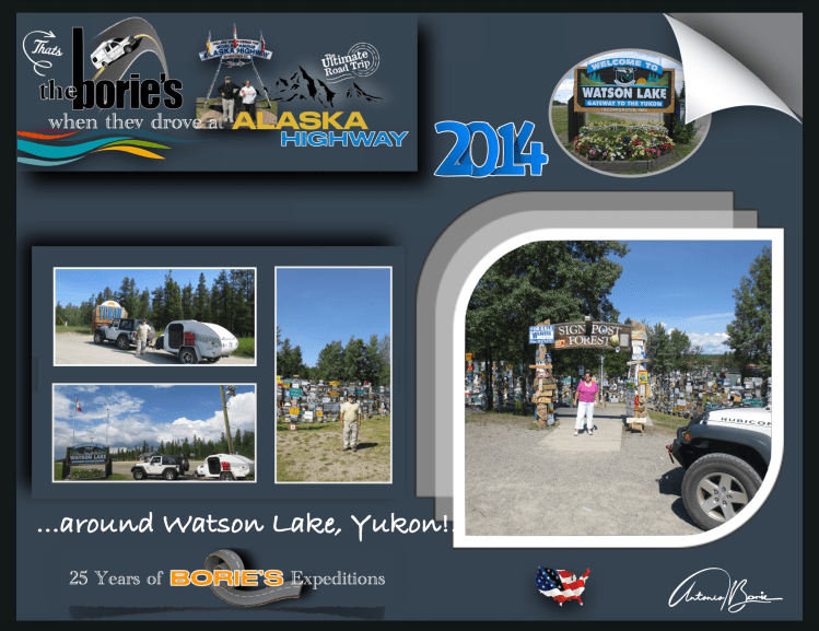
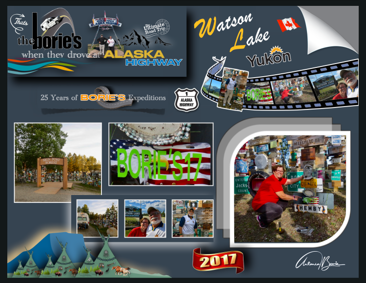
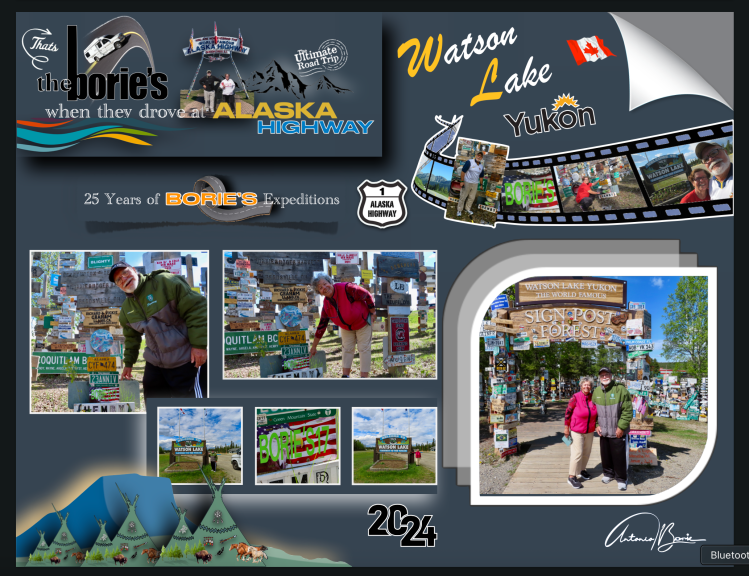
…é a milha 635 e chegámos à cidade Watson Lake, que é uma cidade situada na província do Yukon, um território no noroeste do Canadá, que é selvagem, montanhoso e pouco povoado e onde um caçador e prospector de origem americana, se instalou nesta área no final do século XIX!.
…it’s mile 635 and we arrived at the city of Watson Lake,which is a city located in the province of Yukon,a territory in the northwest of Canada,which is wild, mountainous and sparsely populated and where a hunter and prospector of American origin settled in this area at the end of the 19th century!.
…no entanto hoje, além de ser é um pequeno centro de indústria madeireira, também tem sido um centro de serviços para o sector de mineração onde existem alguns restaurantes, estações de abastecimento de gasolina e uma loja de venda de alguns géneros de primeira necessidade para quem viaja!. Aqui, fomos ver uma placa que assinalava uma nossa passagem, pois já por aqui tínhamos parado e até pernoitado por diversas vezes!.
…however today, in addition to being a small center for the timber industry, it has also been a service center for the mining sector where there are some restaurants, gasoline filling stations and a store selling some basic necessities for those who travel!. Here, we went to see a sign that marked our passage, as we had already stopped here and even stayed the night several times!
…é um local situado na região norte da hoje legendária “Histórica Estrada do Alaska”!. Era a aventura e…, também uma homenagem às pessoas dedicadas e trabalhadoras que com muito trabalho físico, onde era usada a pá, a picareta e a vagoneta, trabalhando muitas horas seguidas, nas mínimas condições de segurança, construíram esta estrada, durante a “World War II”, com o propósito de haver uma via de comunicação terrestre entre o continente dos USA e o estado do Alaska, claro, passando pelo território do Canadá!.
…it is a place located in the northern region of the now legendary “Historic Alaska Highway”!.It was adventure and…, also a tribute to the dedicated and hard-working people who, with a lot of physical work, using shovels, pickaxes and carts, working many hours at a time, in the minimum safety conditions, built this road, during “World War II”, with the purpose of having a land communication route between the mainland of the USA and the state of Alaska, of course, passing through the territory of Canada!.
…porquê?. Porque havia notícias que o Japão queria invadir “Kiska Island” (Ilha de Kiska) e “Attu Island” (Ilha de Attu), na região das “Aleutians Islands” (Ilhas de Aleutians), e claro, tudo tinha que ficar completo antes que chegasse o inverno!.
…why?. Because there was news that Japan wanted to invade “Kiska Island” and “Attu Island”, in the region of the “Aleutians Islands”, and of course, everything had to be completed before winter arrived!.
…mencionando algumas curiosidades desta hoje “Histórica Estrada do Alaska”,, não existe em todo o seu percurso um único túnel, tudo foi feito à pressa, à luz do dia, sempre improvisando, com os recursos que naquela ocasião existiam, fazendo todas as curvas, que o acidentado do terreno mostrava!. Em algumas zonas, não sendo possível seguir, rasgavam o lado das montanhas, de onde tiravam terra, cascalho ou pedra, para colocar em alguns terrenos mais baixos, que eram alagadiços!.
…mentioning some curiosities of today’s “Historic Alaska Highway”,there is not a single tunnel along its entire route, everything was done in a hurry, in daylight, always improvising, with the resources that existed at that time, making all the curves, which the rugged terrain showed!. In some areas, when it was not possible to follow, they tore up the side of the mountains, where they took earth, gravel or stone, to place in some lower terrain, which was swampy!.
…e, uma dessas dedicadas pessoas, um soldado do Exército dos USA que se encontrava doente e trabalhava na construção desta hoje famosa “Histórica Estrada do Alaska”, com saudades da sua cidade natal, colocou um sinal com o nome de sua cidade natal e a distância!.
…and, one of these dedicated people, a US Army soldier who was ill and worked on the construction of this now famous “Historic Alaska Highway”, missing his hometown, placed a sign with the name of his hometown and the distance!.
…foi o início para que outros, entre os quais nos inserimos, seguindo o seu exemplo, vindo das mais remotas partes do mundo, continuaram a tradição, onde hoje, neste local designado como uma atracção turística pelo nome de “Signpost Forest”, e que foi iniciado no ano de 1942, já lá existem mais de oito milhares de sinais de vários tipos que retratam locais em todo o mundo, e onde nós também lá deixámos uma placa com o nosso nome e data, no ano de 2017, assinalando uma das nossas passagens!.
…it was the beginning for others, among whom we are included, following their example, coming from the most remote parts of the world, to continue the tradition, where today, in this place designated as a tourist attraction by the name of “Signpost Forest”, and which was started in 1942, there are already more than eight thousand signs of various types that depict places around the world, and where we also left a plaque there with our name and date, in 2017, marking one of our passages!
…uma curiosidade, é que a placa colocada por nós há aproximadamente oito anos, estava intacta, sobrevivendo a todos estes anos de neve, chuva, sol ou frio!.
…a curious fact is that the plaque we placed approximately eight years ago was intact, surviving all these years of snow, rain, sun or cold!
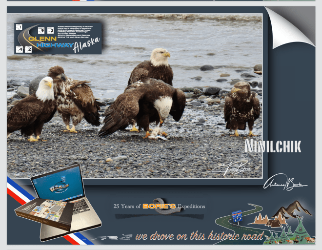
…era numa manhã onde o tempo nem era quente nem frio, era…, “lusco-fusco”, onde algumas águias pescavam nas ondas da praia desta pequena vila de Ninilchik, situada na Península de Kenai, que para nós é um lugar muito especial, porque além de outras coisas, um dialeto russo e raro, que deve de ser uma fusão da língua russa, inglês e línguas indígenas, que nos dão um exemplo sonoro do legado multicultural desta pequena vila, e ainda é lá falado!.
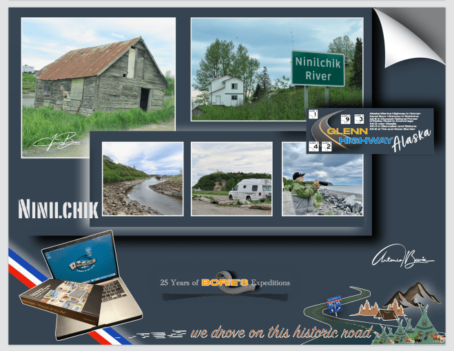
…it was on a morning where the weather was neither hot nor cold, it was…, “twilight”, where some eagles were fishing in the waves on the beach of this small village of Ninilchik,located on theKenai Peninsula,which for us is a very special place, because among other things, a rare Russian dialect, which must be a fusion of the Russian language, English and indigenous languages, which gives us a sound example of the multicultural legacy of this small village, and is still spoken there!.
…não era a primeira vez que lá parávamos, já de outras expedições visitámos este lugar porque fica ao lado da única estrada que nos leva para sul ao longo da Península de Kenai, onde na sua história cultural faz parte a Igreja Ortodoxa Russa de Ninilchik, que é um ponto central, mesclando a liturgia antiga com as tradições da região, onde no seu cemitério histórico revela histórias dos primeiros colonizadores, com lápides marcadas em alfabeto cirílico!.
…it wasn’t the first time we stopped there, we’ve visited this place on other expeditions because it’s next to the only road that takes us south along the Kenai Peninsula,where its cultural history includes the Russian Orthodox Church of Ninilchik, which is a central point, mixing the ancient liturgy with the traditions of the region, where its historic cemetery reveals stories of the first settlers, with tombstones marked in the Cyrillic alphabet!.
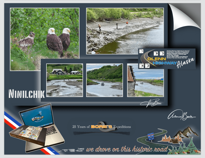
…esta pequena vila foi fundada por volta do ano de 1847, tornando-se um refúgio para funcionários aposentados da Companhia Russo-Americana e suas famílias, que optaram por integrar os seus costumes russos ao modo de vida local e hoje, fazendo de Ninilchik um museu vivo dessa síntese cultural única, estando repleta de construções históricas de madeira em estilo russo que dominam a paisagem, simbolizando a alma russa que perdura em Ninilchik!.
…this small village was founded around 1847, becoming a refuge for retired employees of the Russian-American Company and their families, who chose to integrate their Russian customs into the local way of life and today, making Ninilchik a living museum of this unique cultural synthesis, being full of historic Russian-style wooden buildings that dominate the landscape, symbolizing the Russian soul that endures in Ninilchik!.
…caminhar por aqui é como voltar ao estilo de vida de subsistência que os primeiros colonizadores, incluindo os comerciantes de peles russos, teriam vivido neste terreno acidentado no início do século XIX!. Este cenário pitoresco, com as suas robustas casas de pescadores, em madeira, pintam um retrato vívido das suas origens!. Barcos de pesca encalhados aqui e ali, contribuem para o charme e a autenticidade desta pequena vila, refletindo uma mistura de história e natureza, onde os visitantes tal como nós, caminhando ao longo do Rio Ninilchik, podem admirar lá ao cimo o Mirante Panorâmico de Ninilchik, desfrutando também de muitas oportunidades incomparáveis para pesca ou coleta de mariscos!.
…walking here is like returning to the subsistence lifestyle that early settlers, including Russian fur traders, would have lived in this rugged terrain in the early 19th century!. This picturesque setting, with its robust wooden fishermen’s houses, paints a vivid portrait of its origins!. Fishing boats stranded here and there contribute to the charm and authenticity of this small village, reflecting a mix of history and nature, where visitors like us, walking along theNinilchik River,can admire the Ninilchik Panoramic Viewpointfrom above, also enjoying many incomparable opportunities for fishing or shellfish gathering!.
…não sabemos se viveremos o suficiente para poder voltar a esta maravilhosa e pequena vila de Ninilchik, mas a verdade é que ao a deixar-mos para trás a caminho do norte…, a levámos no coração!.
…we don’t know if we will live long enough to be able to return to this wonderful little village of Ninilchik, but the truth is that when we left it behind on our way to the north…, we took it in our hearts!.
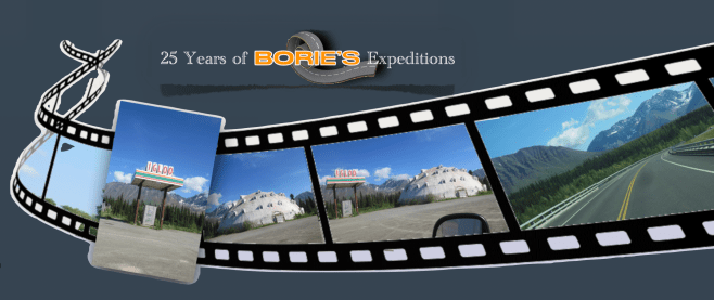
…saímos da cidade de Fairbanks pela manhã e viajávamos no sentido sul pela estrada “GeorgeParks Highway”!. Aproximadamente a 22 milhas ao sul da pequena cidade de Cantwell, sentimos alguma desilusão ao ver um edifício com estas linhas de construção, representando o célebre “Igloo”, que quando crianças, sempre via-mos nas histórias dos “livros aos quadradinhos, e quando se referiam ao Polo Norte”, que está fechado, abandonado e em princípio de ruínas!.
…we left the city of Fairbanksin the morning and traveled south along the “George Parks Highway”!. Approximately 22 miles south of the small town of Cantwell,we felt some disappointment when we saw a building with these construction lines, representing the famous “Igloo”,which as children, we always saw in stories in “square books, and when they referred to the North Pole”, which is closed, abandoned and in principle ruins!.!.
…o lugar é conhecido como “Igloo City”, e este “Igloo”, cuja construção foi iniciada na década de 1970, nunca foi concluído como um hotel, devido a problemas financeiros e códigos de construção!. A sua estrutura em forma de cúpula de vários andares, fica ao lado do já acima referido “George Parks Highway” e hoje, tornou-se um marco para exploradores urbanos e turistas, apesar do seu estado de degradação, devido ao clima e algum vandalismo!.
…the place is known as “Igloo City”,and this“Igloo”,whose construction began in the 1970s, was never completed as a hotel, due to financial problems and building codes!. Its multi-story dome-shaped structure is next to the aforementioned “George Parks Highway”and today, it has become a landmark for urban explorers and tourists, despite its state of degradation, due to the weather and some vandalism!.
…está dentro de uma propriedade privada, com acesso restrito, habitada por alguns ursos e outros animais, e a seu lado norte, também lá está um posto de gasolina abandonado, um enorme estacionamento de cascalho, algumas cabanas fechadas e um banheiro externo!. Tudo isto num terreno de 38 acres e sem eletricidade, situado ao longo de um trecho de estrada muito bonito e onde se podem ver montanhas ainda com alguma neve no seu pico, mas…, no meio de nada, neste estado do Alaska!.
…it is inside a private property, with restricted access, inhabited by some bears and other animals, and on its north side, there is also an abandoned gas station, a huge gravel parking lot, some closed cabins and an external bathroom!. All this on a 38-acre plot of land without electricity, located along a very beautiful stretch of road and where you can see mountains with some snow still on their peaks, but…, in the middle of nowhere, in this state of Alaska!.
…nas nossas três expedições ao estado do Alaska, sempre parámos para apreciar esta estrutura de 25 metros de altura e 30 metros de largura, que à distância parece ser uma cúpula de concreto repleta de janelas, até que chegamos perto o suficiente e poder ver o seu esqueleto salpicado de grafites, tornando-se numa estranheza americana de primeira linha, onde os viajantes, tal como nós, que viajam pela solitária “George Parks Highway”, entre Fairbanks e Anchorage, passam de carro ou caravana, e simplesmente ficam boquiabertos, às vezes parando para tirar selfies ou fazer o seu xixi, antes de seguir em frente!.
…on our three expeditions to the state of Alaska, we always stopped to appreciate this 25 meter high and 30 meter wide structure, which from a distance appears to be a concrete dome full of windows, until we get close enough to see its skeleton dotted with graffiti, becoming a first-class American oddity, where travelers, like us, who travel the lonely “George Parks Highway”,between Fairbanksand Anchorage,pass by car or caravan, and simply gawk, sometimes stopping to take selfies or pee, before moving on!.
…para nós, este “Igloo”, tornou-se uma presença marcante e estranhamente amada na paisagem do Alaska e…, ao aprecia-lo, sem qualquer dúvida que nos faz renascer a apreciação que temos por este 49º estado, e claro, é um lugar que nós visitantes lembramos com carinho, tal qual como o vizinho Parque Nacional Denali!.
…for us, this “Igloo”,has become a striking and strangely loved presence in the Alaskan landscape and…, when appreciating it, without any doubt it makes us reborn the appreciation we have for this 49th state, and of course, it is a place that we visitors remember fondly, just like the neighboring Denali National Park!.
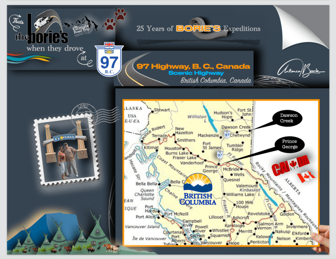
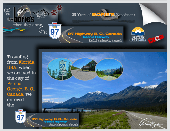
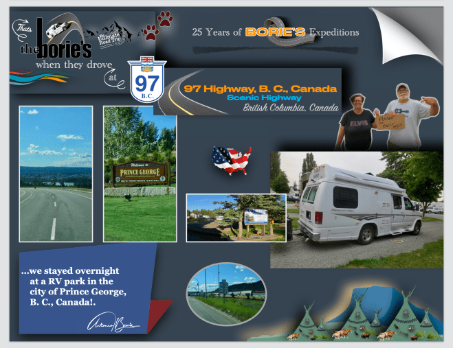
…tínhamos passado a noite num parque de RV na cidade de Prince George, British Columbia, Canada, uma cidade situada junto aos rios Fraser e Nechako, onde as suas origens são referentes a um posto de comércio de peles da North West Company de Fort George, por Simon Fraser, que aqui se estabeleceu por volta do ano de 1807, e o nome foi dado em homenagem ao rei George III!. O posto de comércio de peles, foi centrado na pátria centenária da Primeira Nação Lheidli T’enneh, cujo nome significa “pessoas da confluência dos dois rios”!.
…we had spent the night in an RV park in the city of Prince George, British Columbia, Canada, a city located along the Fraser and Nechako rivers, where its origins refer to a fur trading post of the North West Company of Fort George, by Simon Fraser, who settled here around 1807, and was named in honor of King George III!. The fur trading post was centered on the centuries-old homeland of the Lheidli T’enneh First Nation, whose name means “people of the confluence of the two rivers”!.
…o nosso destino era o norte!. Como tal, o dia ainda não tinha clareado e já estávamos a viajar no Highway 97, no sentido norte!. Esta estrada é a rota mais longa continuamente na província da Columbia Britânica e a maior estrada provincial em qualquer outra província, contudo nós queríamos chegar apenas até à cidade de Dawson Creek!.
…our destination was the north!. As such, the day had not yet lightened and we were already traveling on Highway 97, heading north!. This road is the longest continuously route in the province of British Columbia and the longest provincial road in any other province, yet we only wanted to get as far as the town of Dawson Creek!
…esta estrada está dividida em diversas seções, e passa através de uma região quase selvagem e em grande parte despovoada, que segue por entre montanhas, planícies e lagos, levando o número da rota 97 dos USA, com a qual se conecta na fronteira internacional, e inicialmente foi designada como “97”, no ano de 1953!.
…this road is divided into several sections, and passes through an almost wild and largely unpopulated region, which runs between mountains, plains and lakes, bearing the number of US route 97, with which it connects at the international border, and was initially designated as “97”, in 1953!.
…por exemplo, começámos por viajar na secção John Hart!. Este trecho de aproximadamente 405 km de extensão (252 milhas) da Estrada 97, nome dado pelo ex-primeiro ministro britânico John Hart, que começa em Prince George!.
...for example, we started by traveling in the John Hart! section. This approximately 405 km long (252 miles) stretch of Highway 97, named by former British Prime Minister John Hart, begins in Prince George!.
…depois, viajando por 152 km (94 milhas) ao norte através da pequena aldeia de Summit Lake, que está situado no Continental Divide, bem como através do Parque Provincial Crooked River, Bear Lake e McLeid Lake, até ao seu cruzamento com a Estrada 39!.
…then traveling 152 km (94 miles) north through the small village of Summit Lake, which is situated on the Continental Divide, as well as through Crooked River Provincial Park, Bear Lake and McLeid Lake, to its intersection with Highway 39!.
…e continuando a viajar para nordeste mais 150 km (93 mi), através da Continental Divide, em que ponto o fuso horário muda de Hora do Pacífico, para o Tempo da Montanha!.
…and continuing to travel northeast another 150 km (93 mi), across the Continental Divide, at which point the time zone changes from Pacific Time, to Mountain Time!.
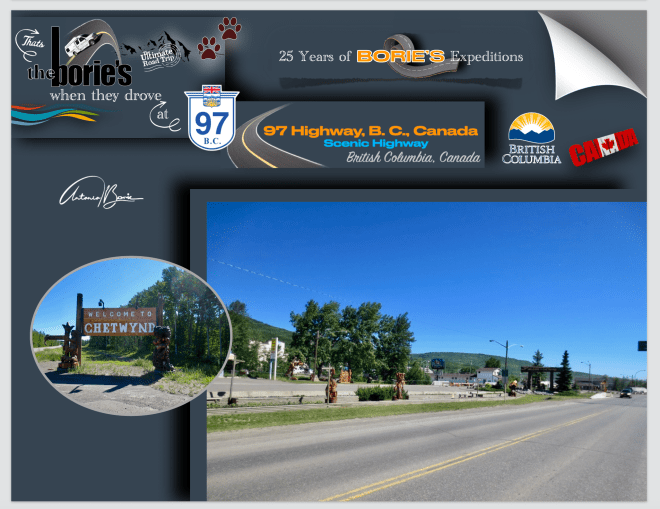
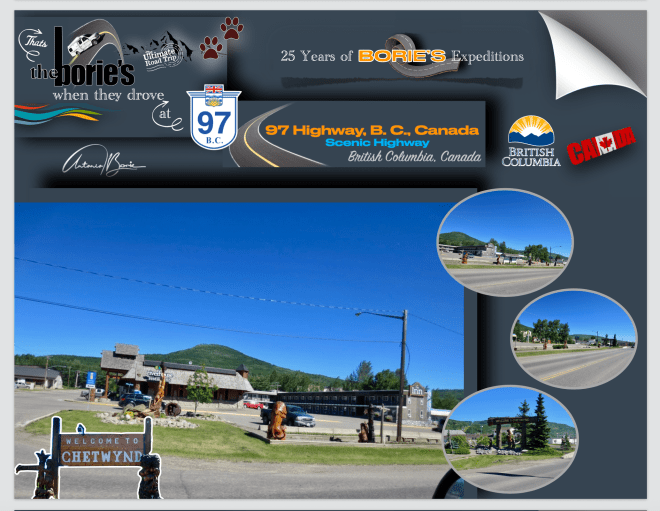
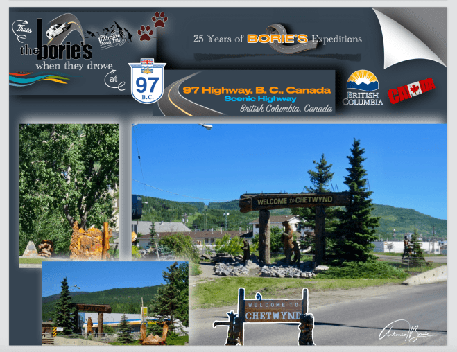
…depois de sair do Pine Pass, e viajando pela Estrada 29, chegamos à cidade de Chetwynd, onde parámos.
…after leaving Pine Pass, and traveling along Route 29, we arrived at the town of Chetwynd, where we stopped!.
…paramos em Chetwynd por duas razões, a primeira foi apreciar as obras de arte em madeira que se espalham ao longo da Estrada 97, que nos dizem que Chetwynd é a pequena comunidade mais habitável da Columbia Britânica, de acordo com um grupo, a silvicultura, a mineração, o processamento de gás natural, a pecuária, a agricultura e a energia eólica são as principais indústrias!.
…we stopped in Chetwynd for two reasons, the first was to appreciate the wooden artwork that dots along Highway 97, which tells us that Chetwynd is the most livable small community in British Columbia, according to one group, forestry, mining, natural gas processing, ranching, agriculture and wind energy are the main industries!.
…e a segunda razão, foi a mudança de óleo na nossa “White Fox” (caravana),que se queixava que já tinha as milhas suficientes e, necessitava de novo óleo!.
…and the second reason was the oil change in our “White Fox” (caravan), which complained that it already had enough miles and needed new oil!.
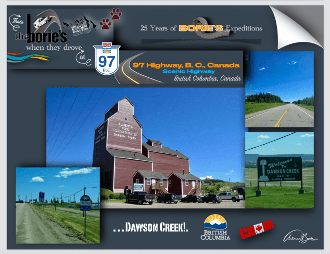
…e após um percurso de outros 97 km (60 mi) para leste, a estrada John Hart, finalmentetermina em Dawson Creek, que é uma típica cidade cujo nome deriva dum riacho que por ali passa com o mesmo nome, que por sua vez o recebeu de um tal George Mercer Dawson, que era um membro de uma equipe de pesquisa de terras, que talvez tal como nós, também por aqui passou no longínquo ano de 1879!.
…and after a journey of another 97 km (60 mi) to the east, the John Hart road finally ends in Dawson Creek, which is a typical town whose name derives from a stream that passes through there with the same name, which in turn received it from a certain George Mercer Dawson, who was a member of a land survey team, who perhaps like us, also passed through here in the distant year of 1879!.
…e foi aqui, quando ainda era uma pequena comunidade agrícola, que se tornou num centro regional, após o terminal ocidental da “Northern Alberta Railways”, ser estendido até aqui, no ano de 1932, crescendo rapidamente quando por volta do ano de 1942, o Exército dos EUA usou este terminal ferroviário como um ponto de transbordo, durante a construção do hoje lendário e “Histórico Alaska Highway”!. Passou então a ser chamada de “Capital da Paz”, também conhecida como a “Milha 0”, referindo-se à sua localização no extremo sul desta já referida estrada!.
…and it was here, when it was still a small agricultural community, that it became a regional center, after the western terminal of the “Northern Alberta Railways”, was extended here in 1932, growing rapidly when around 1942, the US Army used this railway terminal as a transfer point, during the construction of the now legendary and “Historic Alaska Highway”!. It then came to be called the “Capital of Peace”, also known as “Mile 0”, referring to its location at the southern end of this aforementioned road!.
…chegamos à província de Alberta, Canadá, que possui duas grandes cidades, uma é Calgary, a maior cidade e a capital financeira, e a outra, que é Edmonton, a capital política e também industrial!.Alberta possui uma das economias mais fortes e influentes do Canadá, onde as suas quintas abastecem todo o país!. Em outras palavras…, dizem que é a província de Alberta que dá de comer ao Canadá!.
…we arrived in the province of Alberta, Canada, which has two large cities, one is Calgary, the largest city and the financial capital, and the other, which is Edmonton, the political and industrial capital!. Alberta has one of the strongest and most influential economies in Canada, where its farms supply the entire country!. In other words…, they say that it is the province of Alberta that feeds Canada!.
…e nós, pela manhã com um “frio de rachar”, continuámos a nossa rota em direcção ao norte, pela estrada #2, onde íamos cumprindo as novas regras de velocidade, que é de 100 km/h (62 mph), e em áreas urbanas varia de 50 km/h (31 mph) a 100 km/h (62 mph), e já viajando na estrada rápida #1, parámos nos arredores da cidade de Calgary para comprar alguns géneros alimentícios e gasolina, que também se vende ao litro!.
…and we, in the morning with a “bitter cold”, continued our route towards the north, along road #2, where we were complying with the new speed rules, which are 100 km/h (62 mph), and in urban areas it varies from 50 km/h (31 mph) to 100 km/h (62 mph), and already traveling on fast highway #1, we stopped on the outskirts of the city of Calgary to buy some food and gasoline, which was also sells by the liter!.
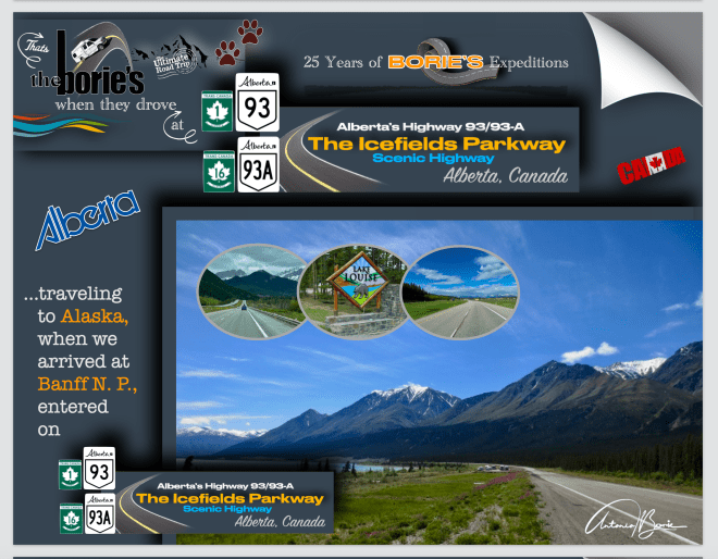
…todavia, o nosso destino era chegar ao “Banff Nacional Parque” na região das “Rocky Mountains”, que é considerada uma reserva de biosfera!. Assim, rumo ao oeste e viajando na Alberta Provincial Highway 1, que normalmente é referida como Highway 1 e é uma grande estrada leste-oeste no sul da província de Alberta, que forma parte do Trans-Canada Highway, chegamos a Banff, entrando no “Parque Nacional Rocky Mountains”, onde nos ofereceram um passaporte para percorrer todos os Parques Nacionais do Canada durante a nossa visita a este lindo e, para nós acolhedor País!.
…however, our destination was to reach “Banff National Park” in the “Rocky Mountains” region, which is considered a biosphere reserve!. So, heading west and traveling on Alberta Provincial Highway 1, which is normally referred to as Highway 1 and is a large east-west road in the south of the province of Alberta, which forms part of the Trans-Canada Highway, we arrived in Banff, entering the “Rocky Mountains National Park”, where we were offered a passport to tour all of Canada’s National Parks during our visit to this beautiful and, for us, welcoming country!.
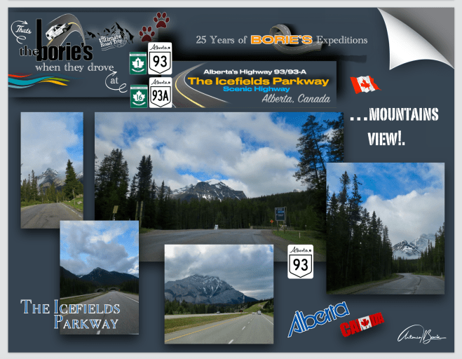
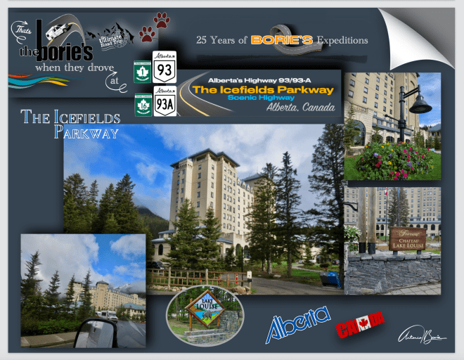
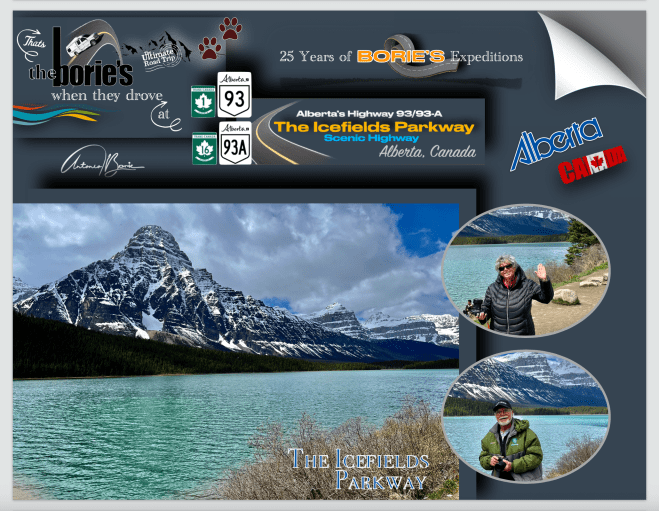
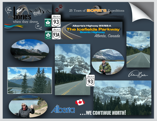
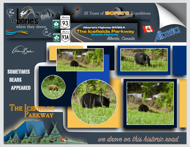
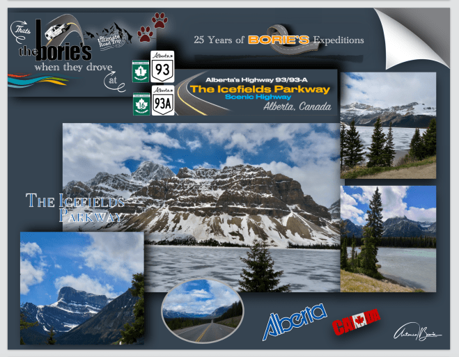
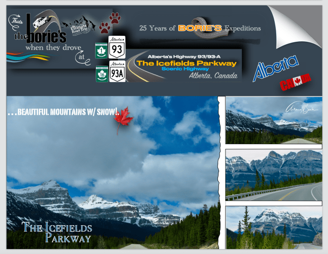
…e continuando rumo ao norte, agora na estradanúmero 93, que também lhe chamam “Banff-Windermere Parkway” ou “Icefields Parkway”, onde depois de qualquer curva nos aparece um cenário em que temos de parar a nossa “White Fox” (caravana), admirar e tirar fotos, porque não é só o cenário de montanha, são os Glaciers, os lagos, a neve sobre as rochas, em alguns lugares entrando na água cristalina, as florestas ou os animais selvagens que nos aparecem constantemente!. Enfim, se pensamos demorar 4 horas para atravessar esta estrada, nem em 8 horas se consegue ver o mínimo!.
…and continuing towards the north, now on road number 93, which is also called “Banff-Windermere Parkway” or “Icefields Parkway”, where after any curve a scene appears in which we have to stop our “White Fox” (caravan), admire and take photos, because it’s not just the mountain scenery, it’s the Glaciers, the lakes, the snow on the rocks, in some places entering the crystal clear water, the forests or the wild animals that constantly appear to us!. Anyway, if we think it will take 4 hours to cross this road, you won’t even be able to see the slightest in 8 hours!
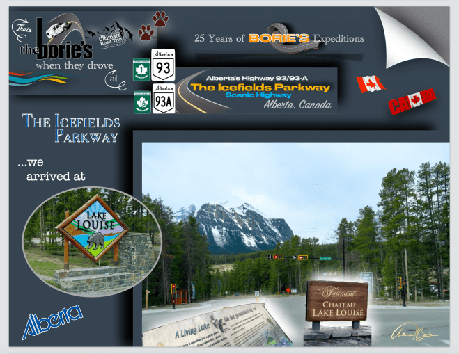
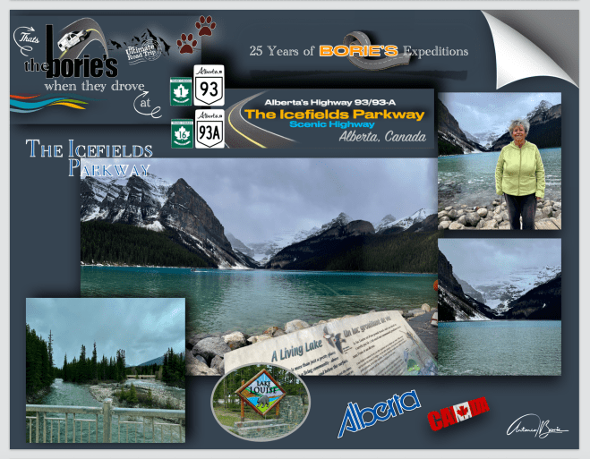
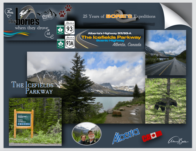
…uma das nossas paragens foi em Lago Louise, a quem deram o nome, em homenagem à princesa Louise Caroline Alberta, a quarta filha da rainha Victoria!. Era assim no passado, tudo o que era importante, levava o nome de reis, rainhas, princesas ou duques!. No entanto, a aldeia era originalmente chamada Laggan, e era uma das várias estações que existem ao longo da rota do “Canadian Railway do Pacífico”!.
…one of our stops was at Lake Louise, which they named after Princess Louise Caroline Alberta, the fourth daughter of Queen Victoria!. It was like that in the past, everything that was important was named after kings, queens, princesses or dukes! However, the village was originally called Laggan, and was one of several stations that exist along the route of the Canadian Pacific Railway.
…mas voltando ao Lago Louise, é um dos lagos mais visitados do mundo!. A seu lado está o emblemático hotel Fairmont Chateau Lake Louise, queé património Mundial da UNESCO e que normalmente aparece em fotos, no cinema, na televisão, revistas ou em livros de romance, sempre rodeado por algumas montanhas, onde se destaca o Victoria Glacier, e claro, o já citado lago com cor esmeralda, cintilante e também majestoso!.
…but back to Lake Louise, it is one of the most visited lakes in the world!. Next to it is the emblematic Fairmont Chateau Lake Louise hotel, which is a UNESCO World Heritage Site and which normally appears in photos, cinema, television, magazines or romance books, always surrounded by some mountains, where the Victoria Glacier stands out. , and of course, the aforementioned emerald-colored lake, sparkling and also majestic!.
…também passámos pelo Lago Moraine, que fica localizado a algumas milhas do Lago Louise, que nos oferece uma vista panorâmica do Vale dos Dez Picos!. Esta cena foi retratada no verso das notas de 20 dólares do Canadá, na série de 1969-1979 “Scenes of Canada”!.
…we also passed Moraine Lake, which is located a few miles from Lake Louise, which offers a panoramic view of the Valley of the Ten Peaks!. This scene was depicted on the back of Canadian $20 bills in the 1969-1979 series “Scenes of Canada”!
…seguindo sempre em direção ao norte, através duma região com um cenário de montanha, onde as florestas são dominadas pelo pinheiro em altitudes mais baixas, com lagos e riachos correndo revoltosos aqui e ali e, se olhar-mos para cima da linha das árvores, admiramos principalmente rochas e gelo, que lá devem de estar talvez à milhares de anos!.
…heading ever northwards, through a region with mountain scenery, where the forests are dominated by pine at lower altitudes, with lakes and streams running wildly here and there, and if we look up the line From the trees, we admire mainly rocks and ice, which must have been there for perhaps thousands of years!.
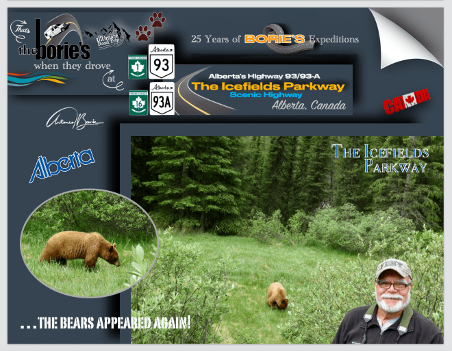
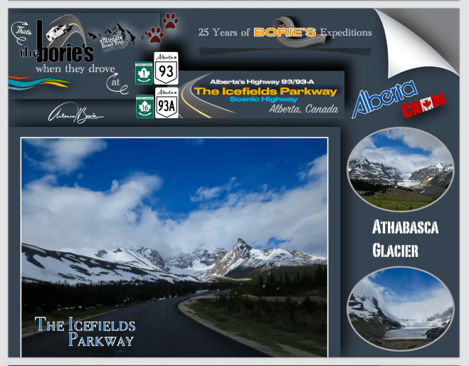
…é constante o aparecimento de mamíferos como o urso pardo, o puma, o alce ou o carneiro selvagem, além de centenas de espécies de aves, que vivem por aqui, naquelas montanhas formadas a partir de rochas sedimentares que foram empurradas para o leste por estratos rochosos mais recentes, entre 80 e 55 milhões de anos atrás, pois talvez nos últimos milhões de anos, as geleiras cobriram a maior parte do parque, mas hoje são encontradas apenas nas encostas das montanhas, embora incluam o “Columbia Icefield”, a maior massa glacial ininterrupta das Montanhas Rochosas, onde a erosão da água e do gelo esculpiu as montanhas nas suas formas atuais!.
…the appearance of mammals such as the brown bear, the puma, the elk or the wild sheep is constant, as well as hundreds of species of birds, which live here, in those mountains formed from sedimentary rocks that were pushed into the east by more recent rock strata, between 80 and 55 million years ago, as perhaps in the last few million years, glaciers covered most of the park, but today they are found only on the mountainsides, although they include the “Columbia Icefield.” , the largest uninterrupted glacial mass in the Rocky Mountains, where water and ice erosion sculpted the mountains into their current forms!.
…continuando, dizem-nos, de que em Julho ou Agosto, mais de 100,000 veículos circulam por esta estrada em cada mês, pois a estrada 93, é uma estrada com duas vias, uma em cada sentido, dividida ao meio por aquelas marcas amarelas, que quase todos os condutores conhecem mas, de tantos em tantos quilómetros, tem pistas de passagem ocasionais!. Isto minimiza o atraso nas viaturas que rolam mais devagar para os seus ocupantes apreciarem melhor o cenário!. Já nos esquecíamos de vos dizer que quando virem muitos veículos parados na berma da estrada, é certo que estão apreciando algum animal selvagem, que resolveu atravessar a sua estrada, pois o local é deles, ou então resolveu vir “mostrar-se”!.
…continuing, we are told that in July or August, more than 100,000 vehicles travel along this road each month, as road 93 is a road with two lanes, one in each direction, divided in half by those yellow markings, which almost all drivers know but, every few kilometers, there are occasional passing lanes)!. This minimizes delay in vehicles that move slower so that their occupants can better appreciate the scenery! We already forgot to tell you that when you see many vehicles stopped on the side of the road, it is certain that they are enjoying some wild animal, which decided to cross your road, as the place is theirs, or else it decided to come and “show itself”!.
…wow, wow, wow,… tanta história da natureza para ainda hoje se poder admirar!.
…wow, wow, wow,… so much history of nature that you can still admire today!.
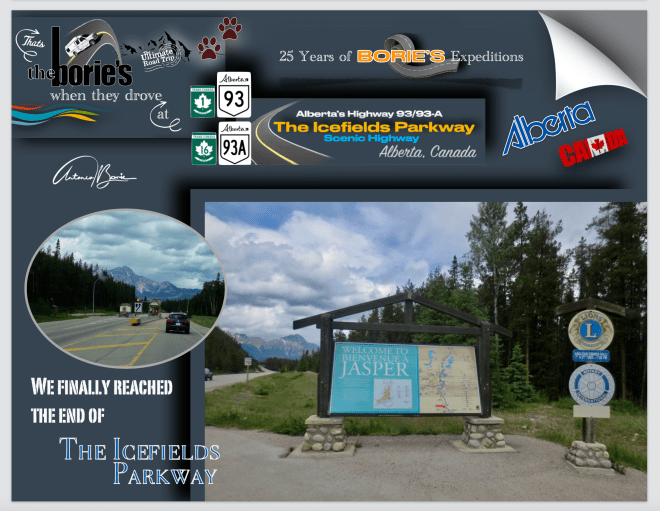
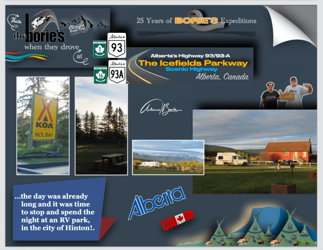
…continuando, ainda com algum cenário de montanha, entrámos na estrada rápida #16, que acompanha de perto o caminho para norte do país, no mesmo alinhamento da “Canadian National Railway”, que nos levou até perto da cidade de Hinton, ainda na província de Alberta, onde pernoitámos num parque de RV!.
…continuing, still with some mountain scenery, we entered the fast road #16, which closely follows the route to the north of the country, in the same alignment as the “Canadian National Railway”, which took us close to the city of Hinton, still in province of Alberta, where we spent the night in an RV park!.
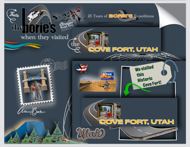
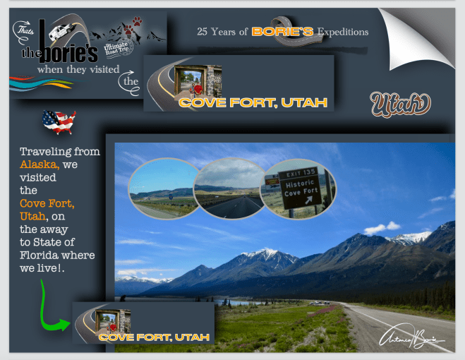
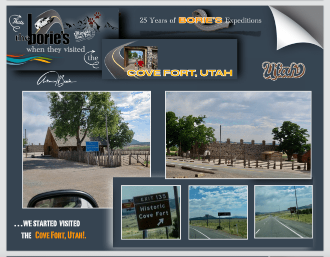
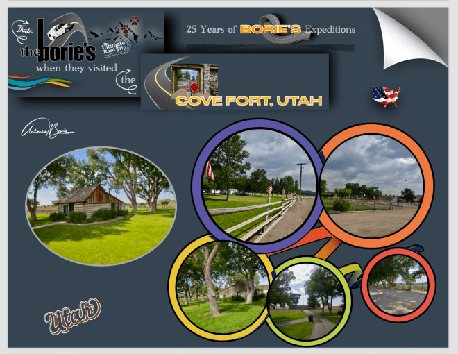
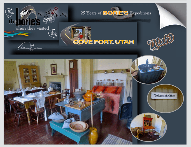
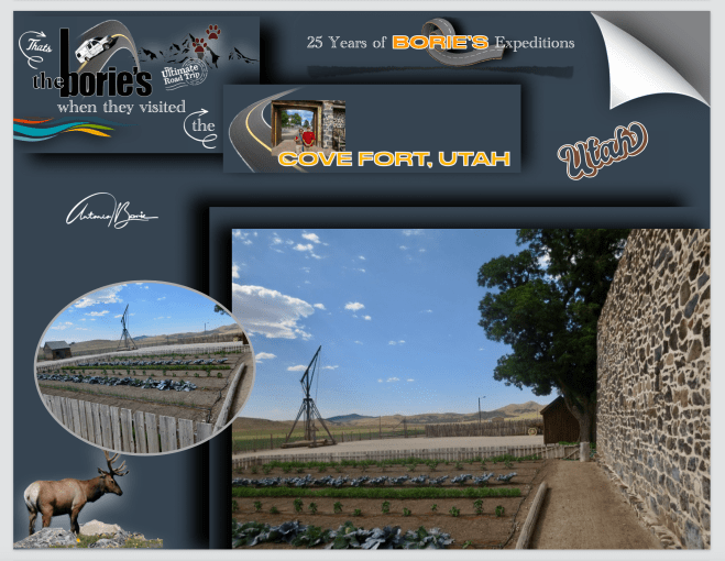
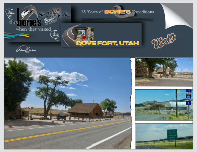
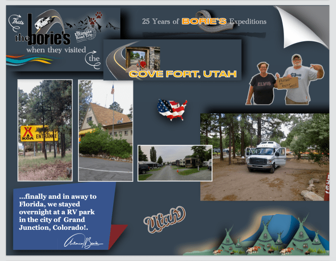
…vindos do norte, viajando no Highway #15 na direção sul, chegámos à região do condado de Millard, no Utah!. Parámos em Cove Fort, que é um lugar mais conhecido para o terminal ocidental do Highway I-70, que termina próximo, sendo mencionado como um lugar de controle, em sinais de auto-estradas, embora o Cove Forte seja histórico e, não tenha população permanente!.
…coming from the north, traveling on Highway #15 in a southerly direction, we arrived in the region of Millard County, Utah!. We stopped at Cove Fort, which is a more well-known place for the western terminus of Highway I-70, which ends nearby, being mentioned as a control place, on highway signs, although Cove Fort is historic and has no permanent population!.
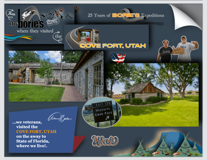
…hoje é um lugar histórico, sendo fundado no ano de 1867 por Ira Hinckley (o avô paterno de Gordon B. Hinckley) a pedido de Brigham Young, e uma das suas características distintivas é a utilização de rocha vulcânica na construção das paredes, em vez da madeira utilizada em muitos fortes ocidentais de meados do século XIX. Esta diferença na construção é a razão pela qual é um dos poucos fortes deste período que ainda sobrevivem!.
…today it is a historic place, being founded in 1867 by Ira Hinckley (Gordon B. Hinckley’s paternal grandfather) at the request of Brigham Young, and one of its distinctive features is the use of volcanic rock in the construction of the walls, instead of the wood used in many western forts of the mid-19th century!. This difference in construction is the reason why it is one of the few forts from this period that still survive!.
…e, uma das principais razões porque este lugar foi selecionado pelo já acima mencionado Brigham Young, (que foi um líder religioso e político, sendo o segundo presidente da Igreja de Jesus Cristo dos Santos dos Últimos Dias, desde 1847 até sua morte em 1877, e que também serviu como o primeiro governador do Território de Utah de 1851 até sua renúncia em 1858), foi a sua estratégica localização, a meio caminho entre Fillmore, antiga capital do Território de Utah, e a cidade mais próxima, Beaver, proporcionando assim uma estação de caminho, para pessoas que viajavam pelo Corredor Mormon!.
…and, one of the main reasons why this site was selected by the aforementioned Brigham Young, (who was a religious and political leader, being the second president of the Church of Jesus Christ of Latter-day Saints, from 1847 until his death in 1877, and who also served as the first governor of the Utah Territory from 1851 until his resignation in 1858), was its strategic location, midway between Fillmore, the former capital of Utah Territory, and the nearest city, Beaver, thus providing a way station for people traveling the Mormon Corridor!.
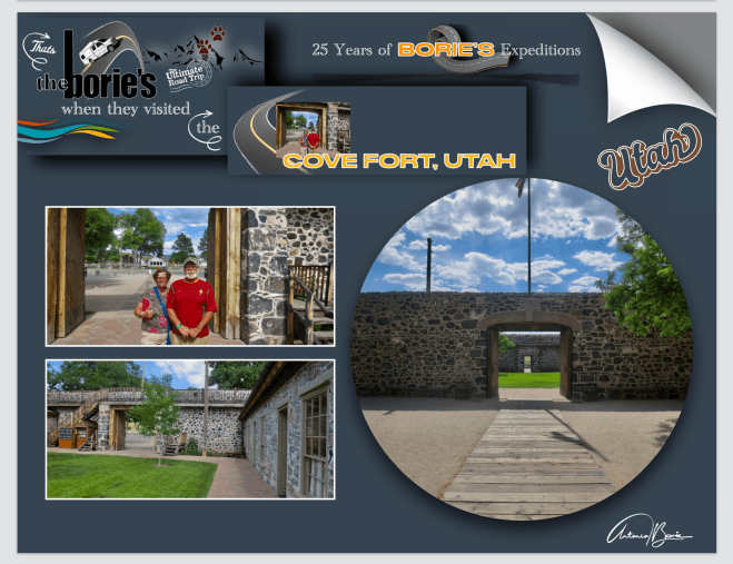
…o Cove Fort, é um quadrado com 30 m de cada lado!. As paredes são construídas com rocha vulcânica negra e calcário escuro, ambos extraídos das montanhas próximas!. As paredes têm 18 pés de altura e 4 pés de espessura na base, afinando para 2 pés de espessura no topo!. O forte tem dois conjuntos de grandes portas de madeira nas extremidades leste e oeste, originalmente preenchidas com areia para impedir flechas e balas, e contém 12 salas internas, seis na parede norte e seis na parede sul!.
…the Cove Fort, is a square with 30 m on each side!. The walls are built from black volcanic rock and dark limestone, both quarried from nearby mountains!. The walls are 18 feet high and 4 feet thick at the base, tapering to 2 feet thick at the top!. The fort has two sets of large wooden doors at the east and west ends, originally filled with sand to stop arrows and bullets, and contains 12 internal rooms, six in the north wall and six in the south wall!.
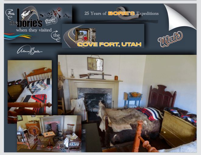
…naquela época, como uma paragem diária para duas linhas de diligências, bem como muitos outros viajantes, Cove Fort foi fortemente usado por muitos anos, muitas vezes habitando e alimentando até 75 pessoas por dia, além de dar um lugar para descansar, um ferreiro/agricultor residia no forte, que calçava cavalos e bois e também reparava rodas de carroças e diligências. Também tinha um escritório de telégrafo e era uma paragem do Pony Express!.
…at that time, as a daily stop for two stagecoach lines as well as many other travelers, Cove Fort was heavily used for many years, often housing and feeding up to 75 people a day, as well as providing a place to rest, a blacksmith/farmer resided in the fort, who shod horses and oxen and also repaired wagon and stagecoach wheels. It also had a telegraph office and was a Pony Express stop!.
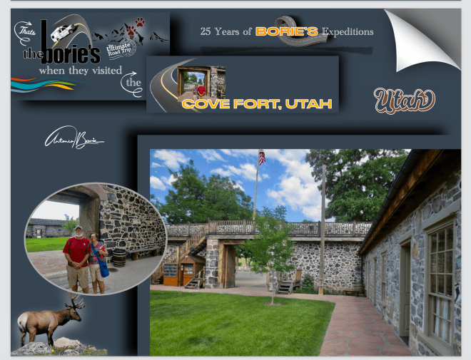
…uma amável pessoa foi o nosso guia, que nos ia abrindo as portas e explicando com algum pormenor todas as instalações deste forte, que como acima já explicámos, foi uma estação intermediária para pessoas que viajavam pela Estrada Mormon. No entanto, já anteriormente uma aldeia ou cidade teria sido construída no local de Cove Fort, mas o abastecimento de água era inadequado para sustentar uma população considerável!.
…a kind person was our guide, who opened the doors to us and explained in some detail all the facilities of this fort, which, as we explained above, was an intermediate station for people traveling along the Mormon Road!. However, previously a village or town would have been built on the site of Cove Fort, but the water supply was inadequate to support a sizeable population!.
…e, um dos fatores chave para a seleção deste local foi a existência anterior de um forte com paliçada de madeira, o Forte Willden, que depois forneceu abrigo e segurança para as equipes de trabalho que construíram o Forte Cove!.
…and, one of the key factors in the selection of this site was the previous existence of a wooden palisaded fort, Fort Willden, which later provided shelter and security for the work crews who built Fort Cove!.
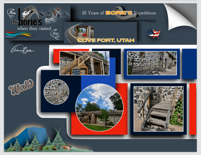
…já vamos longe na nossa descrição, no entanto, ainda existe espaço para mencionar que, foi construído pelos membros de A Igreja de Jesus Cristo dos Santos dos Últimos Dias como um refúgio seguro entre Fillmore, a antiga capital do Território de Utah, e as cidades vizinhas de Beaver e Kanos, e Cove Fort serviu como uma estação importante à medida que Utah e o resto do Ocidente se tornavam mais estabelecidos!. No entanto, devido ao abastecimento inadequado de água que seria necessário para sustentar uma cidade ou aldeia, ela nunca foi totalmente povoada!.
…we’re already far enough into our description, however, there’s still room to mention that it was built by members of The Church of Jesus Christ of Latter-day Saints as a safe haven between Fillmore, the former capital of Utah Territory, and the neighboring cities of Beaver and Kanos, and Cove Fort served as an important station as Utah and the rest of the West became more established! However, due to the inadequate supply of water that would be needed to sustain a city or village, it was never fully populated!
…para terminar e como curiosidade, no ano de 1988, a família Hinckley comprou o forte e doou-o à Igreja. A Igreja restaurou o forte, transportou a cabana de Ira Hinckley em Coalville, Utah, para o local, construiu um centro de visitantes e reabriu o forte como local histórico!. O local oferece visitas guiadas gratuitas diariamente, começando por volta das 8h até meia hora antes do pôr do so!l.
…to finish and as a curiosity, in 1988, the Ira Hinckley family bought the fort and donated it to the Church. The Church restored the fort, moved Ira Hinckley’s cabin in Coalville, Utah, to the site, built a visitor center, and reopened the fort as a historic site! The site offers free guided tours daily, starting at around 8am until half an hour before sunset.
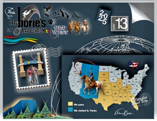
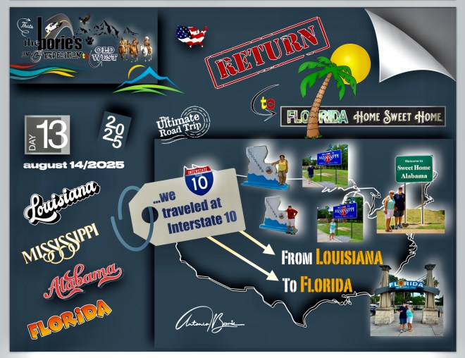
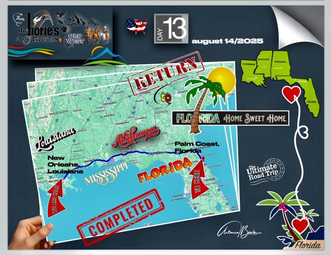
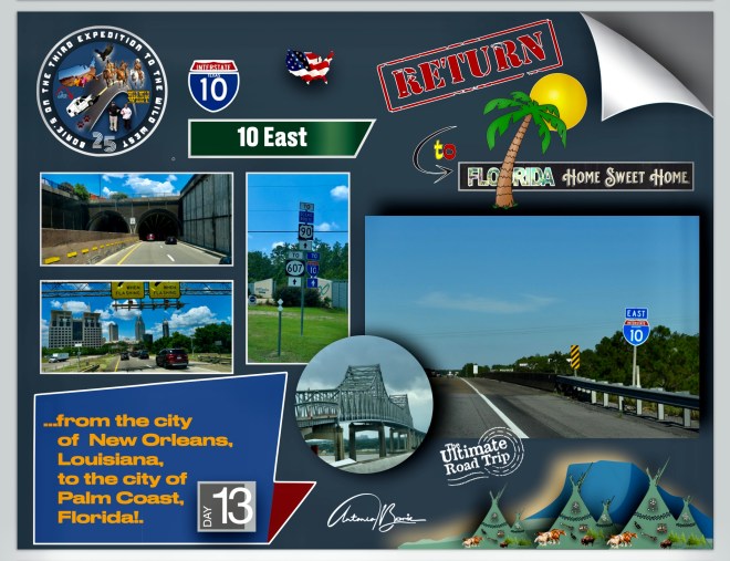
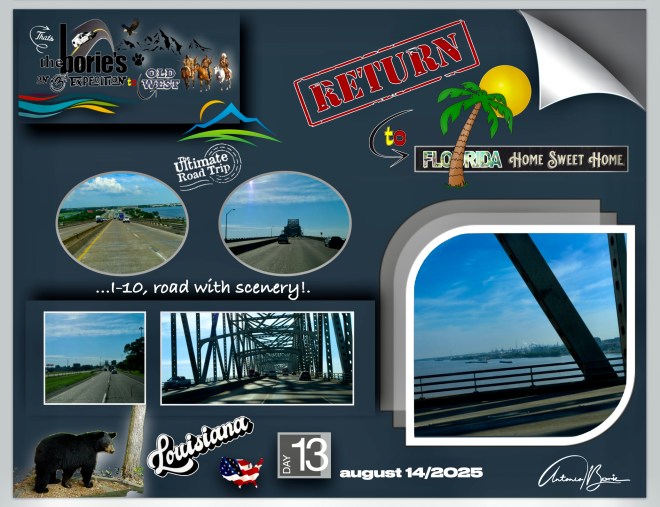
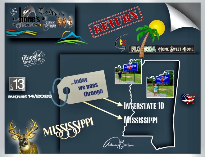
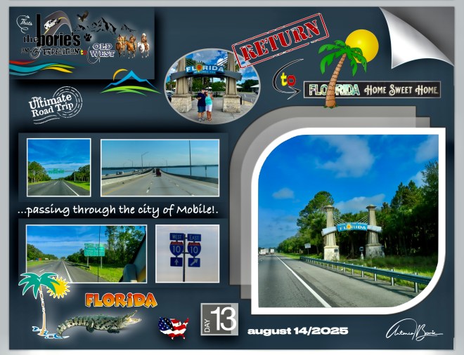
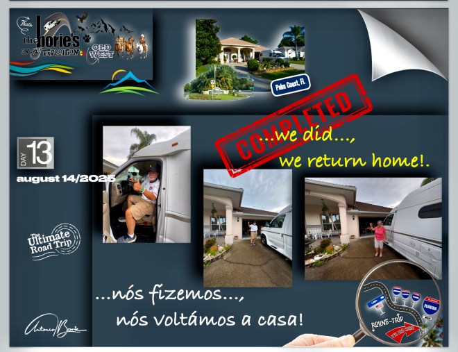
…no último dia da nossa “Terceira Expedição ao Antigo Oeste”, passando pelos estados de Louisiana, Mississippi e Alabama…, finalmente chegámos à Flórida, onde vivemos e regressámos de novo!. O tempo foi de quase céu azul com algumas nuvens brancas!. O que “pretendíamos era viajar para leste, ou seja, chegar a casa”!. Como tal, a história do dia…, não tem história!.
…on the last day of our “Third expedition to the Old West”, passing through the states of Louisiana, Mississippi and Alabama…, we finally came to Florida, where we lived and returned again!. The weather was almost blue sky with some white clouds!. What we “intended was to travel east, that is, to get home”!. As such, the story of the day…, there is no history!.
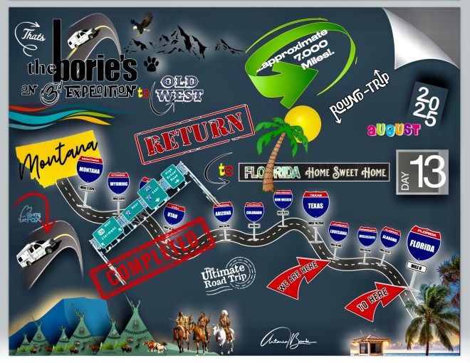
…e finalmente…, chegamos a casa!. Foram 13 dias e noites, 7.446 milhas percorridas, 2.112 fotos e atravessando 22 estados nos USA!. Passamos por cidades, vilas, aldeias, estradas de montanha, (onde mesmo sendo verão, havia neve no seu cume e só estavam abertas ao publico dois a três meses ao ano), parques nacionais, com temperaturas de calor algumas vezes infernal, algum frio, chuva, lama, poeira, pedra miúda, reparações ou desvios de estradas destruídas por avalanches, ou até ventos fortes tal qual tornados, e…, também lindos dias de céu azul, através de planícies, rios ou pequenos riachos!.
…and finally…, we got home!. It was 13 days and nights, 7,446 miles traveled, 2,112 photos and crossing 22 states in the USA!. We passed through cities, villages, villages, mountain roads (where even if it is summer, there was snow on its summit and only two to three months old a year were open), national parks, with temperatures of heat sometimes infernal, some cold, rain, mud, dust, stone, repairs or deviations of roads destroyed by avalanches, or even strong winds, and…, also beautiful days of blue sky, sky, sky blue sky through plains, rivers or small streams!.
…foi uma viagem panorâmica semelhante a uma viagem no tempo, aprendendo sempre, muitas vezes sendo atraídos por aventuras ao ar livre, explorando lugares históricos ou simplesmente mergulhando numa atmosfera descontraída, tendo oportunidade de poder explorar exposições e artefactos que nos ofereceram informações sobre o passado, que às vezes abrigava tesouros históricos, proporcionando-nos uma apreciação mais profunda do seu significado cultural!.
…it was a panoramic trip similar to a time trip, always learning, often being attracted to outdoor adventures, exploring historical places or simply plunging into a relaxed atmosphere, having the opportunity to explore exhibitions and artifacts that offered us information about the past, which sometimes housed historical treasures, providing us with a deeper appreciation of its cultural meaning!.
…ao longe víamos grandes ou pequenas montanhas com alguma neve, outras cobertas com floresta, estradas com duas vias e rápidas, outras pequenas, com curvas e precipícios, com o piso em lama e água!. Parávamos aqui e ali, para admirar a natureza pura, com os animais ou aves selvagens no seu próprio território, onde nós sim…, éramos os intrusos que ocupávamos o seu espaço!.
…in the distance we saw large or small mountains with some snow, some covered with forest, two -way and fast roads, some small, curved and cliffs, with the floor in mud and water!. We stopped here and there, to admire pure nature, with the animals or wild birds in their own territory, where we yes…, we were the intruders we took up their space!.
…vimos e fomos convivendo com pessoas de outras latitudes, mas com o mesmo sentido de aventura, muitas vezes debaixo de um sol radiante, outras, tal como acima já descrevemos, frio, chuva, lama ou poeira e nuvens escuras e…, não sabendo onde era o nosso destino para esse dia, ou onde pernoitaríamos!.
…we saw and were living with people of other latitudes, but with the same sense of adventure, often under a radiant sun, others, as we already describe, cold, rain, mud or dust and dark clouds and…, not knowing where it was our destination for that day, or where we would stay!.
…e coisas assim, só acontecem a quem anda na estrada e adora ver cenários deslumbrantes, onde não existe vontade de sair deles, e…, dormindo sempre na nossa “White Fox” (caravana) e…, acordando com vista para lagos, cujo cenário, só se vê em revistas de propaganda das agências de viajem!. Enfim, uma experiência única, na vida de qualquer pessoa!.
…and things like that, only those who walk on the road and love to see stunning scenarios, where there is no desire to get out of them, and…, always sleeping in our “White Fox” (caravan) and…, waking up with lakes, whose scenery, only finds itself in propaganda magazines of travel agencies!. Anyway, a unique experience, in anyone’s life!.
…e, consideramo-nos uns privilegiados, porque depois desta aventura…, chegámos a casa!. Até um dia destes, companheiros de jornada!.
…and we consider ourselves privileged, because after this adventure…, we arrived home!. Until one of these days, companions of journey!
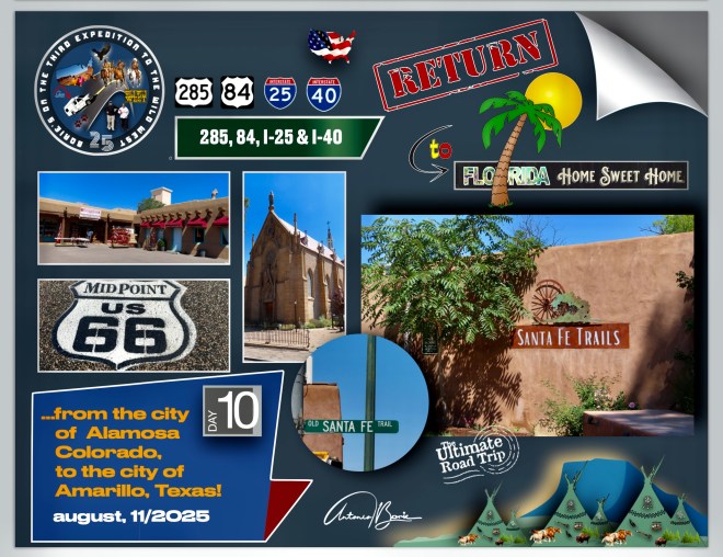
…as montanhas e as superfícies acidentadas do Colorado tinham ficado para trás!. Viajávamos agora em direcção ao sul, onde as planícies eram constantes!. Eram regiões onde por volta dos anos de1800, o comércio de peles se estabeleceu e foram construídos alguns Fortes para proteção e não só!. Entretanto, a famosa trilha de Santa Fe foi estabelecida para trazer mercadorias para Santa Fe, Novo México e, por onde ia passando estabeleciam-se aldeias, principalmente entre Santa Fe e o Missouri!.
…the mountains and rugged surfaces of the Colorado had been left behind!. We were now traveling south, where the plains were constant!. These were regions where around 1800, the trade of skins settled and some strong for protection and not only were built! However, the famous Santa Fe trail was established to bring goods to Santa Fe, New Mexico and, where the villages were passed, especially between Santa Fe and Missouri!.
…onde por exemplo o Forte de Bent, situado no sudeste do Colorado, serviu como posto avançado para negociar com o sul, com os índios e com os caçadores das planícies, trazendo alguma civilização para estas pradarias!. Todavia, o negócio de peles, principalmente de castor ia acabando e os caçadores voltaram-se para as planícies e…, os grandes rebanhos de búfalos foram dizimados e a terra abandonada!. Era a lei da sobrevivência!.
…where for example Bent Fort, located in southeastern Colorado, served as an advanced post to negotiate with the south, the Indians and the hunters of the plains, bringing some civilization to these prairies!. However, the business of fur, especially the Beaver was ending and the hunters turned to the plains and…, the great flocks of buffalo were decimated and the abandoned land!. It was the law of survival!.
…meditando em toda esta história, chegámos à cidade de Santa Fé, Novo Mexico, que é conhecida pela sua arquitectura no estilo Pueblo e como um viveiro de artes criativas!. Caminhámos por lá, na sua área histórica, com origens espanholas que bem se retratam na sua praça tradicional e nas ruas tortas, pelo menos no seu distrito histórico e ruas vizinhas, com as casas, igrejas e outras estruturas, construídas em Adobe!.
…meditating throughout this story, we arrived at the city of Santa Fe, New Mexico, which is known for its architecture in the Pueblo style and as a nursery of creative arts!. We walked there, in its historic area, with Spanish origins that well portray in its traditional square and crooked streets, at least in its historic district and neighboring streets, with houses, churches and other structures, built in Adobe!.
…no Centro de Visitas, onde gentilmente nos deixaram estacionar a nossa caravana, informaram-nos que a cidade foi fundada em 1610 como capital do Nuevo México, uma província da Nova Espanha!. Santa Fe é a capital estatal mais antiga dos USA e o primeiro assentamento europeu a oeste do rio Mississippi!. Seu nome, espanhol para a “Santa Fé”, é a forma abreviada de seu nome original, a villa real de la Santa Fe de São Francisco de Assís!.
… In the center of visits, where they gently let us park our caravan, they informed us that the city was founded in 1610 as the capital of Nuevo Mexico, a province of New Spain!. Santa Fe is the oldest state capital of the USA and the first European settlement west of the Mississippi!. His name, Spanish for “Santa Fe”, is the abbreviated form of its original name, the Villa Real de la Santa Fe de São Francisco de Assís!.
…entrámos em algumas lojas e galerias de arte, tomando contacto com a sua culinária, que é única do sudoeste, particularmente o uso do Chile vermelho e verde, que aparece com destaque em pratos como enchiladas e burritos, ou seja, uma rica mistura de influências nativas americanas, espanholas e mexicanas!.
…we entered some stores and art galleries, taking contact with its cuisine, which is unique in the southwest, particularly the use of red and green Chile, which appears prominently in dishes such as stuffed and stupid, ie a rich mix of native American, Spanish and Mexican!.
…e também, misturando estas influências indígenas, espanholas e americanas, Santa Fe é considerada a capital cultural do sudoeste dos USA, e é amplamente considerada como uma das grandes cidades de arte e, devido ao seu cenário artístico, algumas celebridades associadas a Hollywood ou músicos com alguma fama, tenham por aqui vivido ou tenham casas na área de Santa Fe!.
…and also, mixing these indigenous, Spanish and American influences, Santa Fe is considered the cultural capital of Southwest of the USA, and is widely regarded as one of the great art cities and, due to their art scene, some celebrities associated with Hollywood or musicians with some fame, have lived here or have houses in the area of Santa Fe!.
…e continuando para sul, ao encontro da estrada Interstate 40, tal como em anteriores viagens, seguirmos na direcção leste, numa rota através da qual, também podemos acompanhar a hoje histórica “Route 66”, onde grandes porções desta histórica estrada, seguem paralelas à já mencionada estrada Interstate 40, com alguns letreiros de saídas para as “Vias dos Trilhos Antigos”, ou seja, para uma qualquer das vias cénicas da também já mencionada e hoje histórica “Route 66”, que ao passar pelas pequenas vilas ou aldeias, não são mais do que estradas de fachada!.
…and continuing to the south, to meet the Interstate 40 road, as in previous trips, we go in the East Direction, on which we can also follow the historical “Route 66”, where large portions of this historic road, follow parallel to the aforementioned Interstate 40, with some exits to the “roads of the old rails”, that is, for any of the already mentioned and now historical roads. “Route 66”, which, passing through small villages or villages, are nothing more than facade roads!.
…e seguimos, parando aqui e ali, apreciando pequenos trechos da cultura popular onde adoptaram as tais secções ignoradas e significativas da antiga “Route 66” nas suas redes de estradas estaduais, com o pomposo nome de “State Route 66” que para nós, incorporam a cultura da aventura, mostrando-nos o cenário dos espaços abertos oferecidos pelo oeste americano, numa rota que serpenteia através das partes mais românticas e célebres desse mesmo oeste, conectando as pequenas vilas e aldeias do centro/oeste com as da Costa do Oceano Pacífico!.
…here and there we would stop, enjoying small snippets of popular culture where they adopted such ignored and significant sections of the old “Route 66” in their state road networks, with the pompous name of “State Route 66” that for us, embody the culture from the adventure, showing us the scenery of the open spaces offered by the American West, on a route that meanders through the most romantic and famous parts of that same West, connecting the small towns and villages of the Midwest with those of the Pacific Ocean Coast!.
…e que em outra época deu esperança aos migrantes que iam a caminho do oeste, para encontrar uma nova vida, definindo uma geração em busca de aventura e liberdade, e nós por ali seguíamos, ouvindo música na rádio da nossa “White Fox” (caravana), bebendo café, comendo biscoitos ou fruta, lembrando aquela família que nos anos trinta do século passado, para se prepararem para a sua viagem até à Califórnia, meteram tudo da sua quinta num calhambeque de 50 dólares, matando os seus dois últimos porcos para fazer um barril de carne de porco salgada, para alimentar as 14 pessoas a bordo do seu calhambeque!.
…and that at one time gave hope to migrants heading west, to find a new life, defining a generation in search of adventure and freedom, and we followed there, listening to music on the radio of our “White Fox” (caravan), drinking coffee, eating cookies or fruit, remembering that family that in the thirties of the last century, to prepare for their trip to California, put everything from their farm in a 50 dollar jalopy, killing their last two pigs to make a barrel of salted pork, to feed the 14 people aboard your jalopy!.
…a estrada Interstate 40, que segue numa extensão de estrada aberta de aproximadamente de 280 milhas de solidão e bastante desolada, entre Albuquerque, Novo México, e Amarillo, Texas, onde além de paragens para camiões onde ocasionalmente existe algumas lojas de conveniência para viajantes, não há muito para ver ou fazer, claro, tirando o maravilhoso cenário de algumas povoações onde tínhamos acesso à já referida histórica “Route 66”, hoje um ícone da América, uma multiplicidade de ideias tais como, a liberdade, o velho oeste ou a solidão do interior americano!.
…the Interstate 40, which follows an open road stretch of approximately 280 miles of solitude and quite desolate, between Albuquerque, New Mexico, and Amarillo, Texas, where in addition to truck stops where occasionally there are some shops convenience for travelers, there is not much to see or do, of course, apart from the wonderful scenery of some villages where we had access to the aforementioned historic “Route 66”, today an icon of America, a multiplicity of ideas such as freedom, the old west or the loneliness of the American countryside!.
…e continuando passámos na cidade de Santa Rosa, que ainda hoje continua um ícone mundialmente famoso da “Route 66” daquela época, como por exemplo o rosto sorridente e satisfeito do Fat Man (homem gordo), que era quem atraía os visitantes do Club Café, conhecido pela sua comida caseira, biscoitos azedos e tortilhas mexicanas de milho azul, e claro, pelo seu Museu com uma grande colecção de carros antigos, camiões, brinquedos, bombas de gasolina e recordações, todos reunidos para celebrar e recordar os dias de glória daquela histórica estrada!.
…and continuing on, we passed the city of Santa Rosa, which still today remains a world famous icon of “Route 66” of that time, such as the smiling and satisfied face of the Fat Man, who was the one who attracted visitors to the Club Café, known for its homemade food, sour cookies and Mexican blue corn tortillas, and of course, for its Museum with a great collection of vintage cars, trucks, toys, gas pumps and souvenirs, all gathered to celebrate and remember the days of glory of that historic road!.
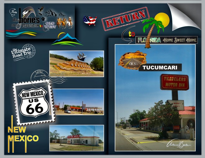
…também parámos na cidade de Tucumcari, onde o tempo quase parece que se esqueceu, crendo nós mesmo que é este um dos motivos que se destaca porque é o quão lindamente desolada é!. A maior parte da sua área circundante ainda hoje funciona como um centro dos fazendeiros rurais do Novo México, oferecendo um hospital, algumas lojas de conveniência, pequenos restaurantes e outras necessidades para a civilização!.
…we also stopped in the city of Tucumcari, where time almost seems to have forgotten, we believe that this is one of the reasons that stands out because it is how beautifully desolate it is!. Most of its surrounding area still functions today as a center for rural New Mexico farmers, offering a hospital, a few convenience stores, small restaurants, and other necessities for civilization!.
…muitos anos atrás, Tucumcari tem uma história única e fascinante, repleta de contos de índios Comanches e, mais tarde quando ali construiram um campo de construção para o Chicago, Rock Island e Pacifico Railroad, que logo foi apelidado de “Six Shooter Siding” (tapada dos seis atiradores), devido a inúmeros tiroteios, pois contam a existência de famosos ladrões de comboios e trabalhadores da construção do caminho de ferro que eram muito propensos em puxar por pistolas uns contra os outros!.
…many years ago, Tucumcari has a unique and fascinating history, filled with tales of the Comanche Indians and, later, when they built a construction field there for the Chicago, Rock Island and Pacifico Railroad, which was soon dubbed the “Six Shooter”, due to numerous shootings, as they tell of the existence of famous train robbers and railway construction workers who were very prone to pulling pistols against each other!.
…nós, atravessámos um trecho de estrada meio próspero e meio abandonado, que nos conta parte da história da cidade, os seus dias de negócios, os seus dias de declínio ou os seus dias de avivamento!.
…we crossed a half-prosperous and half-abandoned stretch of road, which tells us part of the city’s history, its business days, its days of decline or its days of revival!.
…até que chegámos ao estado do Texas, que ironicamente é o maior dos 48 estados mais baixos e acolheu o segundo alinhamento mais curto da Histórica Estrada 66!. A figura geralmente aceite é que havia 178 milhas desta famosa e histórica estrada velha, através do estreito do “Texas Panhandle”, e disto, cerca de 150 milhas permanecem, se quisermos contar a estrada de terra onde ainda se pode conduzir, porque muito da velha e histórica Route 66 é agora estrada de fachada, mas ainda recompensa conduzir por ela!.
…until we arrived in the state of Texas, which ironically is the largest of the lower 48 states and hosted the second shortest alignment of Historic Highway 66!. The generally accepted figure is that there were 178 miles of this famous and historic old road, through the strait of the “Texas Panhandle”, and of this, about 150 miles remain, if you want to count the dirt road where you can still drive, because much of the Old and historic Route 66 is now a front road, but it is still rewarding to drive!.
…e tal como em outros estados do sul, quando a estrada Interstate 40 foi construída, a maior parte desta histórica estrada foi aprimorada, reduzindo os custos de construção e mantendo as cidades existentes próximas à nova estrada rápida, para minimizar as perdas, principalmente do turismo!. Assim, algumas cidades foram ignoradas, onde se incluem Glenrio, Adrian, Vega, Conway, Noivo, Jericó, Alanreed, McLean e Shamrock, contudo, continuamos a ter acesso as estas cidades, onde existem letreiros assinalando a sua localização!.
…and as in other southern states, when the Interstate 40 was built, most of this historic highway was upgraded, reducing construction costs and keeping existing towns close to the new expressway, to minimize losses, mainly from tourism!. Thus, some cities were ignored, including Glenrio, Adrian, Vega, Conway, Noivo, Jericho, Alanreed, McLean and Shamrock,however, we continue to have access to these cities, where there are signs indicating their location!.
…continuando, chegámos à localidade de Adrian, já no estado do Texas, que entre outras curiosidades assinala geograficamente o ponto médio entre Chicago e Los Angeles, da Histórica Estrada 66!.
…continuing, we arrived at the town of Adrian, in the state of Texas, which, among other curiosities, geographically marks the midpoint between Chicago and Los Angeles, of Historic Route 66!.
…a sinalização na localidade de Adrian, orgulhosamente declara uma distância de 1139 milhas para cada lado, ostentando um slogan de que “quando você está aqui, você está no meio do caminho”!. Aqui existe um Café, construído por volta do ano de 1928, que operava 24 horas por dia durante o auge da Histórica Estrada 66, sendo considerado hoje, o mais antigo café, operando continuamente entre Amarillo, no estado doTexas e Tucumcari, já no estado de Novo México!.
…the signage in the town of Adrian, proudly declares a distance 1139 miles each way, sporting a slogan that “when you’re here, you’re halfway there!”. There is a Café here, built around 1928, which operated 24 hours a day during the heyday of Historic Highway 66, being considered today, the oldest café, operating continuously between Amarillo, in the state of Texas and Tucumcari, already in the state of New Mexico!.
…continuámos a nossa viajem e, próximo de Wildorado Creek, talvez a umas tantas milhas de distância já se notava o cheiro no ar que já nos era conhecido de outras ocasiões que por aqui passámos!. Tivemos que fechar as janelas da nossa “White Fox” (Caravana)!. Era um cheiro mau, muito mau que vinha da maior manada de vacas da nossa vida, que deviam de ser milhares, nunca tínhamos visto tantas vacas juntas!.
…we continued our journey and, near Wildorado Creek, perhaps a few miles away, the smell was already noticeable in the air that was already known to us from other occasions that we passed through!. We had to close the windows of our “White Fox” (Caravan)!. It was a bad, very bad smell that came from the largest herd of cows in our lives, which must have been thousands, we had never seen so many cows together!.
…afrouxámos a velocidade, encostando ao lado da estrada, a nossa dedicada esposa Isaura foi fotografando talvez milhares e milhares de manadas de gado bobino, em currais, talvez esperando o transporte no caminho de ferro ou esperando um possível abate, não sabemos, mas o cenário era incomum para quem vive longe do campo e de extensas áreas de pastagem!.
…we slowed down, pulling over to the side of the road, our devoted wife Isaura was photographing perhaps thousands and thousands of herds of cattle, in corrals, perhaps waiting for transport on the railroad or waiting for a possible slaughter, we don’t know, but the scenario was unusual for those who live far from the countryside and extensive pasture areas!.
…Wildorado Creek, é uma comunidade que foi fundada por volta do ano de 1900 como uma localidade ferroviária ao longo da Chicago, Rock Island e Gulf Railroad e, no final dos anos vinte e trinta, Wildorado Creek foi torturado por tempestades de areia e secas mas, o elemento turbulento de algumas localidades em expansão no “Texas Panhandle”, viu o Wildorado Creek como um alvo fácil e, bancos e lojas eram roubados frequentemente!.
…Wildorado Creek, is a community that was founded around the year 1900 as a railroad town along the Chicago, Rock Island and Gulf Railroad, and in the late twenties and thirties, Wildorado Creek was tortured by sandstorms and droughts, but the turbulent element of some expanding localities in the “Texas Panhandle”, saw Wildorado Creek as an easy target, and banks and stores were often robbed!.
…continuando, já próximo da cidade de Amarillo, parámos de novo na atracção da “Route 66”, que consiste em dez Cadillacs já usados ou velhos (1949-1963) enterrados de nariz no chão, e que hoje dá pelo nome de “Cadillac Ranch”, considerado de arte pública e escultura, situado ao longo da “Route 66” a oeste de Amarillo, Texas, que foi inventado e construído por um grupo de hippies artísticos importados de São Francisco!.
…continuing, already close to the city of Amarillo, we stopped again at the attraction of “Route 66”, which consists of ten used or old Cadillacs (1949-1963) buried with their noses in the ground, and which today goes by the name of “Cadillac Ranch”, considered public art and sculpture, located along “Route 66” west of Amarillo, Texas, which was invented and built by a group of artistic hippies imported from San Francisco!.
…os Cadillacs estão no chão como arte há mais tempo do que na estrada como carros, que continuam a ser despojados das suas molduras, algumas danificadas e com muitas manchas de tinta de visitantes como nós que continuam a pintá-los com tinta spray, ficando cada vez mais irreconhecíveis como automóveis!. No entanto, o Cadillac Ranch está mais popular do que nunca, tornando-se num local de ritual para aqueles que viajam pela Estrada Mãe!.
…Cadillacs have been on the ground as art longer than they have been on the road as cars, which continue to be stripped of their frames, some damaged and heavily smeared with paint from visitors like us who continue to spray paint them, leaving increasingly unrecognizable as automobiles!. However, Cadillac Ranch is more popular than ever, becoming a ritual site for those traveling the Mother Road!.
…pernoitámos na cidade de Amarillo, Texas, num excelente Park de RV, que também é propriedade de um dos restaurantes mais populares desta cidade, que proporciona transporte de ida e volta para o restaurante!. Aproveitámos a oportunidade, indo lá comer e, cujo lema é “home of the free 72 onças steak”, que quer mais ou menos dizer que, se alguém conseguir comer um bife de 72 onças, não paga, é de graça!.
…we stayed overnight in the city of Amarillo, Texas, in an excellent RV park, which is also the property of one of the most popular restaurants in this city, which provides round trip to the restaurant!. We took the opportunity, going there to eat and, whose motto is “Home of the Free 72 Steak ounces”, which wants to say that if someone can eat a 72 ounce steak, not paid, it’s free!.
…já é costume parar-mos por aqui, e durante a nossa presença no restaurante, houve três candidatos a comer o enorme bife e, tudo foi acompanhado de um personagem parecido com um mestre de cerimónias, que faz um relato quase minucioso de todo este acontecimento, ou seja, do progresso do candidato e como vai comendo o enorme bife, e falando numa voz muito rápida, parecida com a voz de um relator típico do Texas, de um qualquer leilão de vacas ou cavalos, que nós, pessoas visitantes quase não compreendemos nada, mas que foi divertido, lá isso foi!.
…it is usually to stop here, and during our presence at the restaurant, there were three candidates to eat the huge steak, and everything was accompanied by a character like a master of ceremonies, who makes an almost thorough report of all this event, that is, the candidate’s progress and how he eating the huge steak, and speaking in a very fast voice, similar to the voice of a typical Texas rapporteur, any auction of cows or horses. We, visitors we hardly understand anything, but it was fun, there that was!