…estávamos no estado de Dakota do Sul, bem situado no coração dos USA, um lugar histórico, uma verdadeira “jóia do oeste”, bem conhecido por essa distinção, que para nós, é o lar de algumas das histórias mais coloridas que podemos encontrar no oeste americano, pelo menos para quem não adora apenas uma boa história de pioneiros ou de sobrevivência!. Porquê?.
…we were in the state of South Dakota, well situated in the heart of the USA, a historical place, a true“west jewel”,well known for this distinction, which for us is the home of some of the most colorful stories we can find in the West American, at least for those who don’t just love a good story of pioneers or survival!. Why?.
…porque além de outras razões, Dakota do Sul está marcado para sempre pela exploração precoce de “Lewis e Clark”, dos anos selvagens da corrida ao ouro na década de 1870 ou pela determinação e espírito dos primeiros pioneiros, que como milhares de outros, escolheram por aqui se estabelecer e desenvolver a terra para o bem do país e da expansão dos seus territórios!.
…because in addition to other reasons, South Dakotais forever marked by the early exploitation of “Lewis and Clark”,the wild years of the Gold Running in the 1870s or the determination and spirit of the first pioneers, which like thousands of others, chose here to establish and develop the land for the good of the country and the expansion of their territories!.
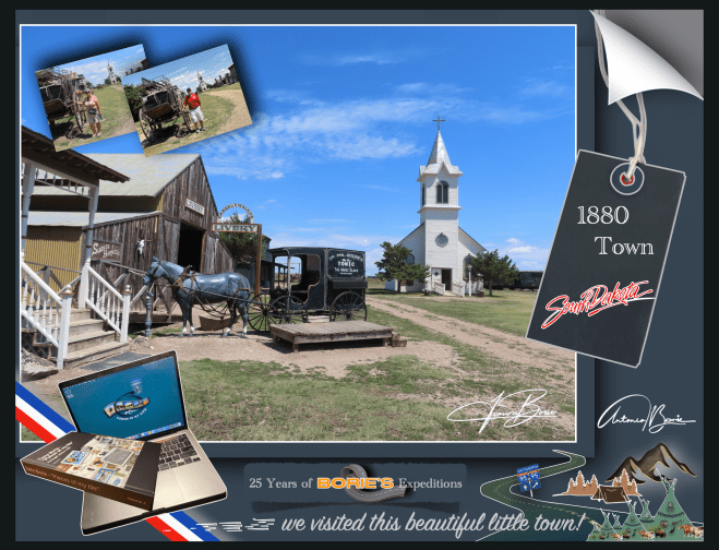
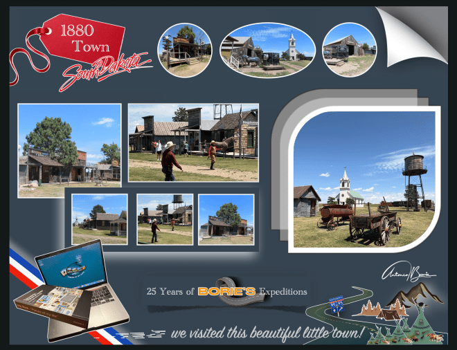
…e, numa rota à volta da estrada rápida #90, que nos havia de levar para Oeste, eis-nos num perfeito ambiente do “Oeste Americano”, com “teatro de rua ao vivo” e tudo!. O lugar, no meio de uma planície deserta, dava pelo nome de “1880 Town”!. Aqui, “os bandidos assaltavam o banco, levando os sacos de ouro, matavam o xerife e os seus ajudantes, aparecendo depois três raparigas bonitas, que por sua vez matavam os bandidos e fugiam em cavalos brancos, com os sacos do ouro!.” Era uma perfeita cena de ”roubar o ouro aos bandidos”!.
…and, on a route around the fast road #90, which would take us west, we found ourselves in a perfect “American West” environment, with “live street theater”and everything!. The place, in the middle of a desert plain, was called “1880 Town”! Here, “the bandits robbed the bank, taking the bags of gold, killed the sheriff and his assistants, and then three beautiful girls appeared, who in turn killed the bandits and fled on white horses, with the bags of gold!.” It was a perfect scene of “stealing the gold from the bandits”!
…e a história diz-nos que naquela época, uma empresa de cinema chegou a uma pequena cidade próxima para filmar um filme da era de 1880!. Um conjunto de “rua principal” foi construído a partir de edifícios antigos e várias relíquias e antiguidades indianas!. O inverno instalou-se, as filmagens foram abandonadas e a empresa de cinema voltou para casa, dando a ”Main Street Set” a alguém para o uso dos seus artefactos!. Anos depois, todo este ”set de filmagem”, foi transferido para estes 80 acres e a cidade de 1880 nasceu!.
…and the story tells us that at that time, a movie company came to a small nearby town to film a 1880!. A set of “main street” was built from old buildings and various relics and Indian antiques!. Winter has settled, filming was abandoned and the movie company returned home, giving the “Main Street Set”to someone to use their artifacts!. Years later, all this “set of footage”was transferred to these 80 acres and the city of 1880 was born!.
…seguíamos em direcção ao leste, pela estrada número 1, a que também chamam Trans-Canada Highway, passando por alguns lugares onde existiam sinais de trânsito indicando saídas para algumas cidades, vilas ou aldeias, como por exemplo, Twillingate ou para as Ilhas do Fogo e da Mudança, mais ao norte, que estavam no nosso roteiro, mas que a recomendação no Centro de Visitantes nos preveniu de não era aconselhável viajar para lá, pelo menos com o equipamento que levávamos!.
…we headed east, along road number 1, which we also call the Trans-Canada Highway,passing through some places where there were traffic signs preventing exits to some cities, towns or villages, such as Twillingateor the Islands of Fireand Change, further north, which we included in our itinerary, but the recommendation at the Visitor Center warned us that it was not advisable to travel there, at least with the equipment we took!.
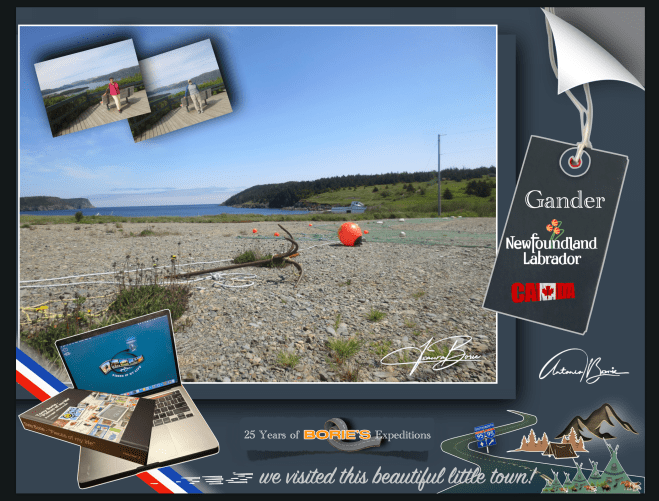
…o dia já ia avançado e, às vezes parecia que viajávamos noutro planeta onde já se começava a ver um pôr do sol dourado que tornava o cenário de pequenas montanhas douradas reflectidas sobre a água de pequenos lagos e riachos, onde o silêncio se estendia por milhas e milhas e…, a nossa dedicada esposa Isaura, procurava na internet um parque de RV para pernoitarmos, que com alguma sorte encontrámos e…, era um local com história!.
…the day was already advanced and, at times, it seemed as if we were traveling through another planet where we were beginning to see a golden sunset that made the scene of small golden mountains reflected on the water of small lakes and streams, where silence stretched for miles and miles and…, our dedicated wife Isaura,was looking online for an RV park for us to spend the night, which with some luck we found and…, it was a place with history!.
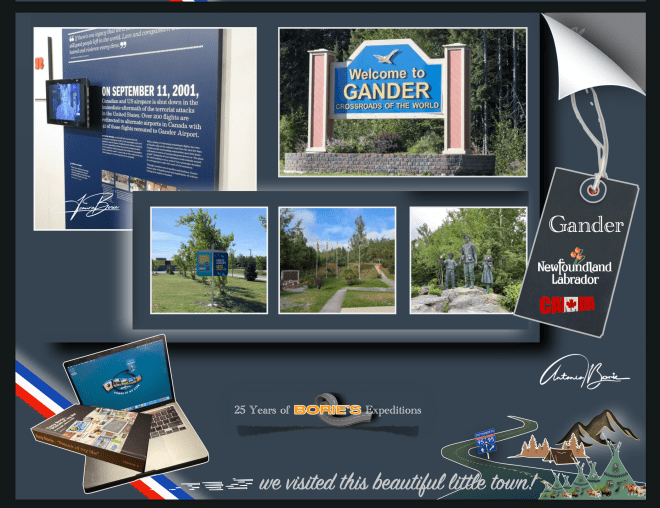
…era a cidade de Gander, na província da Terra Nova no Canadá, que já estava acostumada a receber visitantes internacionais, pois afinal, esta cidade foi construída em torno do seu aeroporto, podendo mesmo dizer-se que “Gander existe por causa de seu aeroporto”, que foi escolhido pela sua localização estratégica nesta ilha oriental do Canadá!.
…it was the city of Gander, in the province of Newfoundland in Canada,which was already used to receiving international visitors, as after all, this city was built around its airport, and it could even be said that “Gander exists because of its airport”, which was discovered due to its strategic location on this eastern island in Canada!.
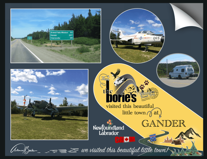
…onde a amável pessoa que nos atendeu, explicando toda a história, logo nos foi dizendo: “óhóoo…, vêm dos USA, tiveram sorte em pernoitar por aqui, pois o nosso generoso e abenegado povo, por ocasião do horrível dia em que o World Trade Center, na cidade de Nova Iorque, foi destruído por um horroroso ataque terrorista, assim como parte do Pentágono, na cidade de Washington e, quase 3.000 pessoas morreram, o nosso Aeroporto Internacional de Gander, recebeu centenas de aeronaves, que transportavam milhares de passageiros e foram obrigadas a pousar”!
…where the kind person who attended to us, explaining the whole story, soon told us: “ohhóoo…, they come from the USA, they were lucky to spend the night here, because our generous and selfless people, on the occasion of the horrible day in which the World Trade Center, in the city of New York, was destroyed by a horrible terrorist attack, as well as part of the Pentagon, in the city of Washington and, almost 3,000 people died, our Gander International Airport, received hundreds of aircraft, which were carrying thousands of passengers and were forced to land”!.
…e continuou: “qualquer um dos aviões no ar naquela manhã de 11 de setembro de 2001, poderia ter sido outro míssil de morte!. Quem sabia quão grande era esse ataque terrorista?. Quando os EUA fecharam seu espaço aéreo, aqui, o nosso pequeno Aeroporto Internacional Gander, na Terra Nova, abriu as suas pistas, onde aterraram 38 aviões de fuselagem larga em rotas transatlânticas”!.
…and continued:“any of the planes in the air that morning of September 11, 2001, could have been another missile of death!. Who knew how big this terrorist attack was?. When the USA closed its airspace, here, our small Gander International Airport, in Newfoundland, opened its runways, where 38 wide-body planes landed on transatlantic routes”!.
…claro, esta amável pessoa, contou-nos mais uma das muitas histórias do horrível 11 de Setembro, onde as pessoas da cidade de Gander, que não eram mais de 10.000, naqueles dias olhavam para todos os aviões alinhados no aeroporto e não falavam em terrorismo, não viam ataques potenciais!. Eles só queriam ajudar!.
…of course, this kind person told us one of the many stories of the horrible September 11th, where the people of the city of Gander, who were no more than 10,000, in those days looked at all the planes lined up at the airport and didn’t talk about terrorism, they didn’t see potential attacks!. They just wanted to help!
…esta cidade, todos os anos, por ocasião do dia 11 de Setembro, lembra os USA, do mal que ninguém conseguiu deter e que infelizmente se alastrou por todo o mundo!. Também nos devemos lembrar da capacidade humana de bondade, abnegação e generosidade que estas pessoas da cidade de Gander e áreas vizinhas tiveram, atravessando magnificamente a crise, respondendo a anúncios de rádio, oferecendo comida, medicamentos, sabonetes, cobertores e até roupas interiores extras, além de ofertas de chuveiros quentes e quartos de hóspedes a todos os 6.579 passageiros e tripulantes das aeronaves!.
…this city, every year, on the occasion of September 11th, reminds the USA of the evil that no one was able to stop and that unfortunately spread throughout the world!. We must also remember the human capacity for kindness, selflessness and generosity that these people of the city of Gander and neighboring areas had, magnificently going through the crisis, responding to radio advertisements, offering food, medicines, soaps, blankets and even extra underwear, in addition to offering hot showers and guest rooms to all 6,579 passengers and crew of the aircraft!.
…onde uma pequena comunidade no meio de uma ilha relativamente isolada no Atlântico Norte, estando muito exposta ao resto do mundo, provavelmente os ajudou a prepararem-se para o que aconteceu em Setembro de 2001, onde revelaram a sua compaixão global integrada na cultura desta comunidade, ficando claro que os passageiros retidos, “pessoas do avião”, como os moradores locais os apelidaram carinhosamente, ficariam lá por dias, que acabaram sendo liberados dos aviões, alguns depois de quase 24 horas numa aeronave paralisada!.
…where a small community in the middle of a relatively isolated island in the North Atlantic, being very exposed to the rest of the world, probably helped them prepare for what happened in September 2001, where they revealed their global compassion integrated into the culture of this community, making it clear that the stranded passengers,“plane people”, as the locals affectionately called them, would be there for days, that they ended up being released from the planes, some after almost 24 hours in a grounded aircraft!.
…sem hesitar, os “Newfoundlanders”, tal como acima já explicámos, abriram as suas casas para que tomassem banho, suas academias escolares, centros comunitários e hotéis para deixá-los dormir e comer refeições quentes; e os seus corações para o desconhecido, após uma tragédia de tal magnitude!.
…without hesitation, the“Newfoundlanders”,as we explained above, opened their homes to bathe, their school gyms, community centers and hotels to let them sleep and eat hot meals; and their hearts towards the unknown, after a tragedy of such magnitude!.
…estas pessoas fizeram tudo isto sem quaisquer instruções, foi algo que realmente veio naturalmente, apenas o fizeram, recebendo em suas casas pessoas estranhas, colocando todos em pé de igualdade de condições, ou seja, ”todas as religiões, todas as políticas, tudo o que fosse, estavam a ser tratadas exactamente da mesma forma”, onde quase 100 nacionalidades representadas, tiveram que comer as comidas mais loucas, onde sobressaiam os favoritos locais, como ensopado de alce e coelho!. Enfim, ”todos estavam sendo alimentados com o mesmo tipo de comida, onde uma pessoa poderia ser milionário e a outra pessoa ao lado poderia estar sem um centavo no bolso, não importava, nesta situação, eram todas iguais”!.
…these people did all this without any instructions, it was something that really came naturally, they just did it, welcoming strange people into their homes, putting everyone on an equal footing, that is, “all religions, all politics, whatever, were being treated exactly the same way”,where almost 100 nationalities represented, had to eat the craziest foods, where local favorites stood out, such as elk and rabbit stew!. Anyway, “everyone was being fed the same type of food, where one person could be a millionaire and the other person next to them could be without a penny in their pocket, it didn’t matter, in this situation, they were all the same”!
…e, tal como nos lembra o musical da Broadway “Come From Away”, a comunidade canadense de Gander acolheu os 6.579 estranhos no seu ceio, naqueles dias mais sombrios dos USA, onde esta comunidade se tornou “numa Pequena Maçã e não a Grande Maçã”, tal como disse o prefeito da cidade, no ano de 2001!.
…and, as the Broadway musical“Come From Away” reminds us, the Canadian community of Ganderwelcomed 6,579 strangers into its midst, in those darkest days in the USA, where this community became “a Little Apple and not the Big Apple”, as the city’s mayor said in 2001!.
…nesta aventura rumo ao norte, não seguimos o mapa do tesouro, do pirata da perna de pau, do papagaio falante, seguimos sim, um mapa moderno, na esperança de ver o cenário que os nossos avós viveram naqueles anos distantes, em que se aventuraram na pesca do peixe bacalhau, lá na gelada região da Terra Nova e do Labrador, Canada!.
…in this adventure heading north, we don’t follow the treasure map, the peg-legged pirate, the talking parrot, we follow a modern map, hoping to see the scenery that our grandparents lived in those distant years, when they ventured out fishing for cod fish, there in the freezing region ofNewfoundland and Labrador, Canada!.
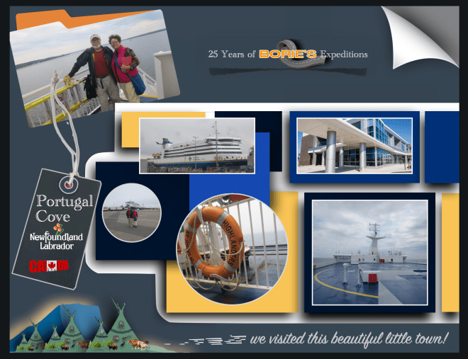
…e, embarcando no navio Highlanders, na cidade portuária de Sydney, na Ilha Cape Breton, na província de Nova Escócia, que é uma das províncias marítimas do leste do Canadá no Oceano Atlântico, parecia que navegámos tal como qualquer famoso pirata das histórias, que viveram durante a Era de Ouro da Pirataria, sobre as águas do Golfo de São Lourenço, que é a saída dos Grandes Lagos da América do Norte através do Rio São Lourenço para o Oceano Atlântico!.
…and, boarding the ship Highlanders,in the port city of Sydney, on Cape Breton Island, in the province of Nova Scotia, which is one of the maritime provinces of eastern Canadain the Atlantic Ocean, it seemed that we sailed just like any famous pirate in history, who lived during the Golden Age of Piracy, over the waters of the Gulf of Saint Lawrence, which is the exit of the Great Lakes of North America through the Saint Lawrence River into the Atlantic Ocean!.
…nós no 9.º andar e a nossa “White Fox” (caravana) no 3.º andar daquele navio que, derivado ao nevoeiro no canal, apitava periodicamente um som forte e lento, não sabemos se arrogante ou de súplica, mas o certo é que, muitas, mesmo muitas horas depois, o nevoeiro ia desaparecendo e já havia terra à vista!.
…we were on the 9th floor and our “White Fox” (caravan) on the 3rd floor of that ship which, due to the fog in the channel, periodically beeped a strong and slow sound, we don’t know if it was arrogant or pleading, but the truth is that, many, even many hours later, the fog was disappearing and land was already in sight!.
…estávamos no porto de Channel-Port aux Basques, cujo cenário nos fazia lembrar as tais aldeias que eram saqueadas pelos já referidos piratas!. No entanto não, não vimos nenhuma dessas personagens, com uma perna de pau, correndo aos saltos, atrás de alguma jovem aldeã, levando uma grande espada numa mão e na outra uma extravagante garrafa de qualquer licor, que normalmente era “rum” de fraca qualidade!.
…we were in the port of Channel-Port aux Basques,whose scenery reminded us of the villages that were plundered by the aforementioned pirates!. However, no, we didn’t see any of these characters, with one peg leg, running in leaps and bounds, after some young village girl, carrying a large sword in one hand and in the other an extravagant bottle of some kind of liquor, which was usually low-quality “rum”!
…o desembarque foi feito normalmente, saindo para terra, conduzindo a nossa “White Fox” (caravana)!. Finalmente estávamos na província de Terra Nova e Labrador, que é a província mais oriental do Canadá, situada na região atlântica do país, que compreende a ilha de Terra Nova e o continente de Labrador a noroeste e…, no nosso percurso, fomos parando aqui e ali, apreciando um cenário de pequenas aldeias piscatórias, muito parecido com os cenários que normalmente vimos nos parques ou filmes do Walt Disney!.
…the disembarkation was done normally, leaving for land, driving our “White Fox” (caravan)!. Finally we were in the province of Newfoundland and Labrador,which is the easternmost province of Canada,located in the Atlantic region of the country, which comprises the island of Newfoundland and the continent of Labrador to the northwest and…, on our route, we stopped here and there, enjoying a scenery of small fishing villages, very similar to the scenes we normally saw in Walt Disney parks or films!.
…e bendizendo a oportunidade de poder visitar esta província, onde se podia apreciar um estilo de vida documental, diferente, levando para aqui espectadores dos quatro cantos do nosso planeta, para descobrir e aprender sobre todos os tipos de peixes exóticos e misteriosos, culturas, num cenário com belas paisagens e pessoas diferentes, que abrem as portas para suas vidas e compartilham as suas histórias com os visitantes!.
…and blessing the opportunity to visit this province, where one could enjoy a different, documentary lifestyle, taking viewers from the four corners of our planet here, to discover and learn about all types of exotic and mysterious fish, cultures, in a setting with beautiful landscapes and different people, who open the doors to their lives and share their stories with visitors!.
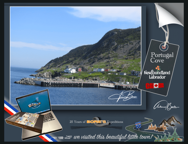
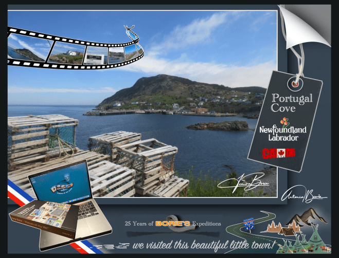
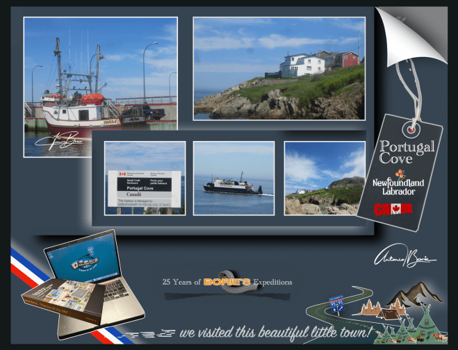
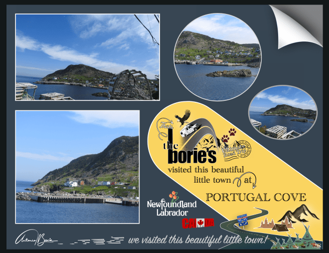
…íamos percorrendo o nosso percurso, até que chegamos à área da aldeia de “Portugal Cove”, que é uma comunidade de litoral rural, localizada na Baía de Concepção, sendo o local de um terminal de pequenos navios que fornece acesso diário de e para a Ilha de Bel, e nós e…, nunca esquecendo a relação dos portugueses com a Terra Nova, que é secular e carrega consigo muitas memórias de aventuras da faina da pesca do bacalhau, pois a história diz-nos que estas terras nunca foram colonizadas por Portugal, apesar das várias viagens de exploração realizadas a estes águas e territórios, talvez impedidos por corsários de outras nações com maior potência militar!.
…we were following our route, until we arrived at the area of the village of “Portugal Cove”,which is a rural coastal community, located in Conceição Bay,being the location of a small ship terminal that provides daily access to and from Bel Island,and we and…, never forgetting the Portuguese relationship with Newfoundland,which is centuries old and carries with it many memories of adventures in cod fishing, as history tells us that these lands were never colonized by Portugal, despite several exploration trips made to these waters and territories, perhaps prevented by privateers from other nations with greater military power!.
…e também sendo nós oriundos de Portugal, parámos para visitar com mais pormenor esta aldeia que dá pelo nome de “Portugal Cove”!. Sim “Portugal Cove” e porquê este nome?. Talvez porque no século XV ou princípios do século XVI, os portugueses daquele tempo, chamavam mesmo à área da Terra Nova, a Terra dos Bacalhaus ou Terra dos Corte Reais!. Mais tarde, por volta dos anos de 1850, em Portugal, uma empreza da cidade de Lisboa chegou a mandar para os bancos pesqueiros da Terra Nova, 19 veleiros, com um total de aproximadamente 325 homens!.
…and also as we come from Portugal, we stopped to visit in more detail this village called “Portugal Cove”!.Yes “Portugal Cove”and why this name?. Maybe because in the 15th century or early 16th century, the Portuguese at that time even called the Terra Nova area the Land of Bacalhaus or Land of Corte Reais!. Later, around the 1850s, inPortugal,a company from the city of Lisbon sent 19 sailboats to the fishing banks of Newfoundland, with a total of approximately 325 men!.
…andámos por aqui e falando com alguns habitantes, ficavam admirados ao dizermos que éramos de descendência portuguesa e iam descrevendo aquilo que sabiam, que o lema da aldeia é “onde o sol encontra o mar’!. Este lema é irónico, já que devido ao posicionamento da Ilha de Bell, na baía, o sol poente nunca encontra o mar a qualquer momento, mas é o seu lema, vai lá saber-se porquê!.
…we walked around and spoke to some inhabitants, they were surprised when we said that we were of Portuguese descent and they described what they knew, that the village’s motto is “where the sun meets the sea”! This motto is ironic, since due to the positioning of Bell Island,in the bay, the setting sun never meets the sea at any time, but it is their motto, let’s find out why!.
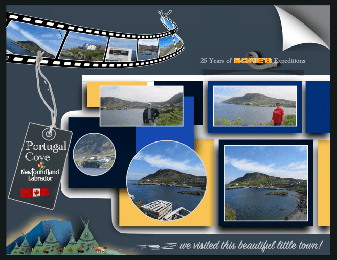
…também nos disseram que “Portugal Cove” é uma comunidade onde existem pequenas quintas, lojas de conveniência, restaurantes ou cafés, lojas de artigos de construção, centros de jardinagem, salões de beleza, garagens e estações de serviço, um serviço de táxi e algumas casas que dão dormida e pequeno almoço, o que já não é pouco!.
…we were also told that “Portugal Cove” is a community where there are small farms, convenience stores, restaurants or cafes, home improvement stores, garden centers, beauty salons, garages and service stations, a taxi service and some houses that provide overnight accommodation and breakfast, which is no small feat!
…na história, a comunidade é uma das mais antigas da Terra Nova, com uma história muito rica, fundada pelos portugueses e, foi uma das primeiras aldeias estabelecidas no novo mundo!. Tem sido históricamente católica romana, sendo servida pela Igreja do Santo Rosário!. Foi o local da primeira estrada construída fora da capital St. John’s!.
…in history, the community is one of the oldest in Newfoundland,with a very rich history, founded by the Portuguese and was one of the first villages established in the new world!. It has historically been Roman Catholic, being served by theChurch of the Holy Rosary!. It was the site of the first road built outside the capital St. John’s!.
…a hoje Enseada de Portugal, tem um grande corpo de tradições folclóricas, pois dizem-nos que a área, já habitada, foi atacada e queimada pelos franceses, no distante ano de 1697 e, foi aqui que a lenda da Lula Gigante ou Kraken, (legendário monstro do mar, parecendo a figura de uma lula gigante), foi descoberta e documentada!. Depois, o nome de Enseada de Portugal, foi dado pelos pescadores Portugueses, por volta do século 17, no entanto outros povos por aqui viveram como pescadores oriundos do oeste da Inglaterra, da Irlanda ou das Ilhas do Canal, como por exemplo Jersey!.
…today Cove of Portugal,has a large body of folklore traditions, as we are told that the area, already inhabited, was attacked and burned by the French, in the distant year of 1697 and, it was here that the legend of the Giant Squid or Kraken, (legendary sea monster, resembling the figure of a giant squid), was discovered and documented!. Afterwards, the name Portugal Cove was given by Portuguese fishermen, around the 17th century, however other people here lived as fishermen from the west of England, Ireland or the Channel Islands, such as Jersey!.
…e também nos informaram que existe outro local com o nome de Enseada de Portugal do Sul, que posteriormente visitámos!. Uma curiosidade, quando pronunciam o nome Portugal, dizem com sotaque de voz em Português!.
…and they also informed us that there is another place called South Portugal Cove, which we later visited!. Interestingly, when they pronounce the name Portugal,they say it with an accent in Portuguese!
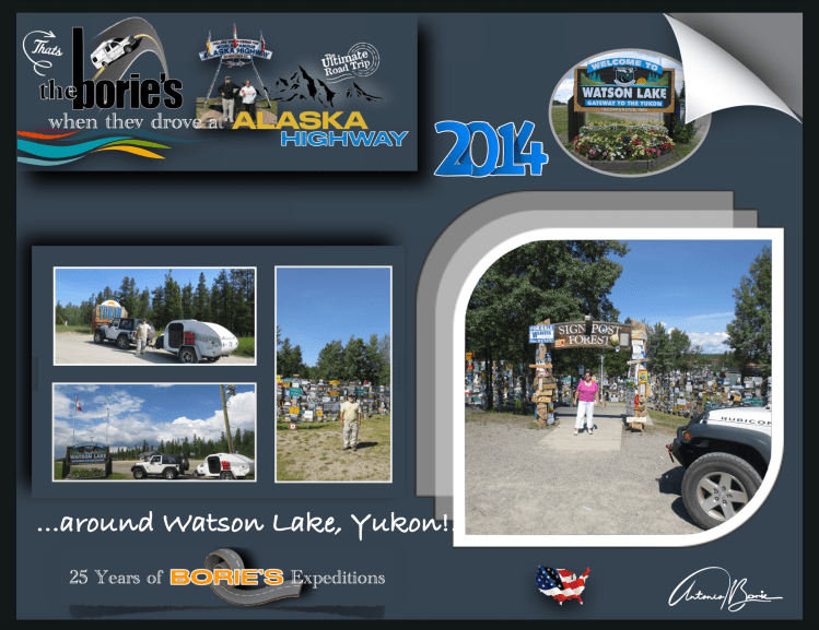
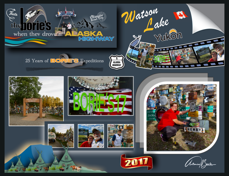
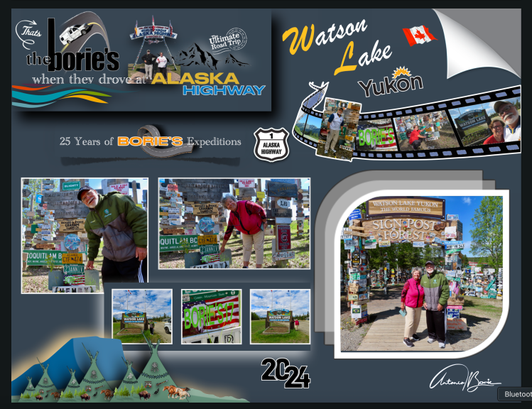
…é a milha 635 e chegámos à cidade Watson Lake, que é uma cidade situada na província do Yukon, um território no noroeste do Canadá, que é selvagem, montanhoso e pouco povoado e onde um caçador e prospector de origem americana, se instalou nesta área no final do século XIX!.
…it’s mile 635 and we arrived at the city of Watson Lake,which is a city located in the province of Yukon,a territory in the northwest of Canada,which is wild, mountainous and sparsely populated and where a hunter and prospector of American origin settled in this area at the end of the 19th century!.
…no entanto hoje, além de ser é um pequeno centro de indústria madeireira, também tem sido um centro de serviços para o sector de mineração onde existem alguns restaurantes, estações de abastecimento de gasolina e uma loja de venda de alguns géneros de primeira necessidade para quem viaja!. Aqui, fomos ver uma placa que assinalava uma nossa passagem, pois já por aqui tínhamos parado e até pernoitado por diversas vezes!.
…however today, in addition to being a small center for the timber industry, it has also been a service center for the mining sector where there are some restaurants, gasoline filling stations and a store selling some basic necessities for those who travel!. Here, we went to see a sign that marked our passage, as we had already stopped here and even stayed the night several times!
…é um local situado na região norte da hoje legendária “Histórica Estrada do Alaska”!. Era a aventura e…, também uma homenagem às pessoas dedicadas e trabalhadoras que com muito trabalho físico, onde era usada a pá, a picareta e a vagoneta, trabalhando muitas horas seguidas, nas mínimas condições de segurança, construíram esta estrada, durante a “World War II”, com o propósito de haver uma via de comunicação terrestre entre o continente dos USA e o estado do Alaska, claro, passando pelo território do Canadá!.
…it is a place located in the northern region of the now legendary “Historic Alaska Highway”!.It was adventure and…, also a tribute to the dedicated and hard-working people who, with a lot of physical work, using shovels, pickaxes and carts, working many hours at a time, in the minimum safety conditions, built this road, during “World War II”, with the purpose of having a land communication route between the mainland of the USA and the state of Alaska, of course, passing through the territory of Canada!.
…porquê?. Porque havia notícias que o Japão queria invadir “Kiska Island” (Ilha de Kiska) e “Attu Island” (Ilha de Attu), na região das “Aleutians Islands” (Ilhas de Aleutians), e claro, tudo tinha que ficar completo antes que chegasse o inverno!.
…why?. Because there was news that Japan wanted to invade “Kiska Island” and “Attu Island”, in the region of the “Aleutians Islands”, and of course, everything had to be completed before winter arrived!.
…mencionando algumas curiosidades desta hoje “Histórica Estrada do Alaska”,, não existe em todo o seu percurso um único túnel, tudo foi feito à pressa, à luz do dia, sempre improvisando, com os recursos que naquela ocasião existiam, fazendo todas as curvas, que o acidentado do terreno mostrava!. Em algumas zonas, não sendo possível seguir, rasgavam o lado das montanhas, de onde tiravam terra, cascalho ou pedra, para colocar em alguns terrenos mais baixos, que eram alagadiços!.
…mentioning some curiosities of today’s “Historic Alaska Highway”,there is not a single tunnel along its entire route, everything was done in a hurry, in daylight, always improvising, with the resources that existed at that time, making all the curves, which the rugged terrain showed!. In some areas, when it was not possible to follow, they tore up the side of the mountains, where they took earth, gravel or stone, to place in some lower terrain, which was swampy!.
…e, uma dessas dedicadas pessoas, um soldado do Exército dos USA que se encontrava doente e trabalhava na construção desta hoje famosa “Histórica Estrada do Alaska”, com saudades da sua cidade natal, colocou um sinal com o nome de sua cidade natal e a distância!.
…and, one of these dedicated people, a US Army soldier who was ill and worked on the construction of this now famous “Historic Alaska Highway”, missing his hometown, placed a sign with the name of his hometown and the distance!.
…foi o início para que outros, entre os quais nos inserimos, seguindo o seu exemplo, vindo das mais remotas partes do mundo, continuaram a tradição, onde hoje, neste local designado como uma atracção turística pelo nome de “Signpost Forest”, e que foi iniciado no ano de 1942, já lá existem mais de oito milhares de sinais de vários tipos que retratam locais em todo o mundo, e onde nós também lá deixámos uma placa com o nosso nome e data, no ano de 2017, assinalando uma das nossas passagens!.
…it was the beginning for others, among whom we are included, following their example, coming from the most remote parts of the world, to continue the tradition, where today, in this place designated as a tourist attraction by the name of “Signpost Forest”, and which was started in 1942, there are already more than eight thousand signs of various types that depict places around the world, and where we also left a plaque there with our name and date, in 2017, marking one of our passages!
…uma curiosidade, é que a placa colocada por nós há aproximadamente oito anos, estava intacta, sobrevivendo a todos estes anos de neve, chuva, sol ou frio!.
…a curious fact is that the plaque we placed approximately eight years ago was intact, surviving all these years of snow, rain, sun or cold!
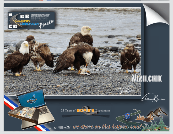
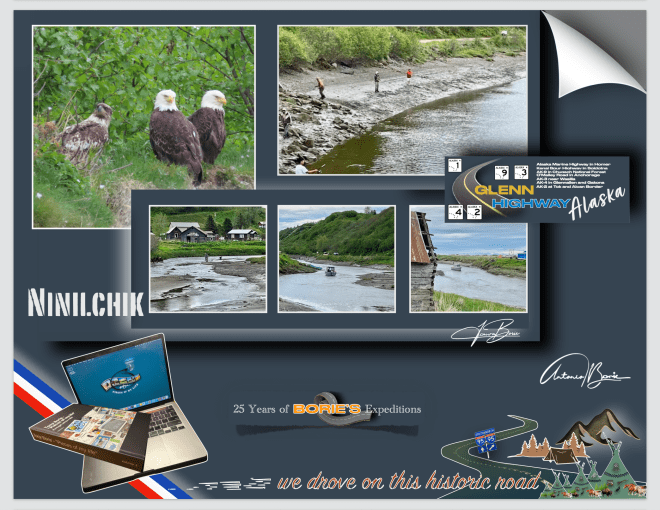
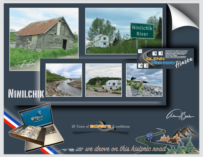
…era numa manhã onde o tempo nem era quente nem frio, era…, “lusco-fusco”, onde algumas águias pescavam nas ondas da praia desta pequena vila de Ninilchik, situada na Península de Kenai, que para nós é um lugar muito especial, porque além de outras coisas, um dialeto russo e raro, que deve de ser uma fusão da língua russa, inglês e línguas indígenas, que nos dão um exemplo sonoro do legado multicultural desta pequena vila, e ainda é lá falado!.
…it was on a morning where the weather was neither hot nor cold, it was…, “twilight”, where some eagles were fishing in the waves on the beach of this small village of Ninilchik,located on theKenai Peninsula,which for us is a very special place, because among other things, a rare Russian dialect, which must be a fusion of the Russian language, English and indigenous languages, which gives us a sound example of the multicultural legacy of this small village, and is still spoken there!.
…não era a primeira vez que lá parávamos, já de outras expedições visitámos este lugar porque fica ao lado da única estrada que nos leva para sul ao longo da Península de Kenai, onde na sua história cultural faz parte a Igreja Ortodoxa Russa de Ninilchik, que é um ponto central, mesclando a liturgia antiga com as tradições da região, onde no seu cemitério histórico revela histórias dos primeiros colonizadores, com lápides marcadas em alfabeto cirílico!.
…it wasn’t the first time we stopped there, we’ve visited this place on other expeditions because it’s next to the only road that takes us south along the Kenai Peninsula,where its cultural history includes the Russian Orthodox Church of Ninilchik, which is a central point, mixing the ancient liturgy with the traditions of the region, where its historic cemetery reveals stories of the first settlers, with tombstones marked in the Cyrillic alphabet!.
…esta pequena vila foi fundada por volta do ano de 1847, tornando-se um refúgio para funcionários aposentados da Companhia Russo-Americana e suas famílias, que optaram por integrar os seus costumes russos ao modo de vida local e hoje, fazendo de Ninilchik um museu vivo dessa síntese cultural única, estando repleta de construções históricas de madeira em estilo russo que dominam a paisagem, simbolizando a alma russa que perdura em Ninilchik!.
…this small village was founded around 1847, becoming a refuge for retired employees of the Russian-American Company and their families, who chose to integrate their Russian customs into the local way of life and today, making Ninilchik a living museum of this unique cultural synthesis, being full of historic Russian-style wooden buildings that dominate the landscape, symbolizing the Russian soul that endures in Ninilchik!.
…caminhar por aqui é como voltar ao estilo de vida de subsistência que os primeiros colonizadores, incluindo os comerciantes de peles russos, teriam vivido neste terreno acidentado no início do século XIX!. Este cenário pitoresco, com as suas robustas casas de pescadores, em madeira, pintam um retrato vívido das suas origens!. Barcos de pesca encalhados aqui e ali, contribuem para o charme e a autenticidade desta pequena vila, refletindo uma mistura de história e natureza, onde os visitantes tal como nós, caminhando ao longo do Rio Ninilchik, podem admirar lá ao cimo o Mirante Panorâmico de Ninilchik, desfrutando também de muitas oportunidades incomparáveis para pesca ou coleta de mariscos!.
…walking here is like returning to the subsistence lifestyle that early settlers, including Russian fur traders, would have lived in this rugged terrain in the early 19th century!. This picturesque setting, with its robust wooden fishermen’s houses, paints a vivid portrait of its origins!. Fishing boats stranded here and there contribute to the charm and authenticity of this small village, reflecting a mix of history and nature, where visitors like us, walking along theNinilchik River,can admire the Ninilchik Panoramic Viewpointfrom above, also enjoying many incomparable opportunities for fishing or shellfish gathering!.
…não sabemos se viveremos o suficiente para poder voltar a esta maravilhosa e pequena vila de Ninilchik, mas a verdade é que ao a deixar-mos para trás a caminho do norte…, a levámos no coração!.
…we don’t know if we will live long enough to be able to return to this wonderful little village of Ninilchik, but the truth is that when we left it behind on our way to the north…, we took it in our hearts!.
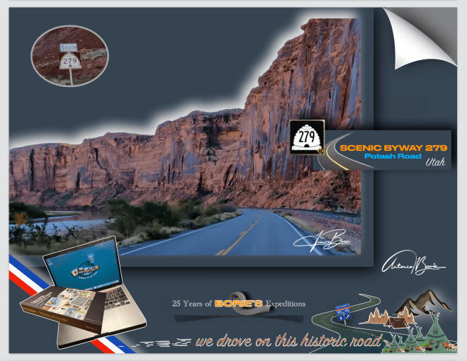
…sempre que passamos próximo do leito do Rio Colorado, não resistimos, temos que percorrer aquela área!. E desta vez, foi uma pequena viajem em fim do dia, pela Utah Scenic Byway 279, também conhecida como Potash Road, que é uma rota impressionante e menos conhecida nos arredores do Moab, Utah, e que nos oferece uma fatia inesquecível do deserto de Utah!.
…whenever we pass close to the bed of the Colorado River,we can’t resist, we have to travel through that area!. And this time, it was a short trip at the end of the day, along Utah Scenic Byway 279, also known as “Potash Road”,which is an impressive and lesser-known route on the outskirts of Moab, Utah,that offers us an unforgettable slice of the Utahdesert!.
…este percurso, é um pequeno trecho de aproximadamente 17 milhas, que começa no US Highway 191 e serpenteia ao longo do Rio Colorado, oferecendo vistas espetaculares de imponentes penhascos de rocha vermelha, curvas e formações rochosas únicas!. Num breve resumo, é uma “coisa preciosa”, que ainda está escondida e que combina em beleza natural, significado histórico, geologia, arqueologia, fotografia ou simplesmente num passeio panorâmico!.
…this route is a short stretch of approximately 17 miles that begins at US Highway 191and winds along the Colorado River, offering spectacular views of towering red rock cliffs, curves and unique rock formations!. In a brief summary, it is a “precious thing”, which is still hidden and which combines natural beauty, historical significance, geology, archeology, photography or simply a panoramic tour!.
…onde, além de tudo o já mencionado, podemos ainda apreciar uma impressionante coleção de pinturas rupestres pré-históricas, gravadas nas paredes rochosas pelos antigos povos nativos americanos!. Estas imagens fascinantes são visíveis desde a estrada e proporcionam um vislumbre da rica história cultural desta região!. Além disso, imponentes falésias de arenito criam um cenário dramático!.
…where, in addition to everything already mentioned, we can also appreciate an impressive collection of prehistoric cave paintings, engraved on the rock walls by ancient Native American people!. These fascinating images are visible from the road and provide a glimpse into the rich cultural history of this region!. Furthermore, towering sandstone cliffs create a dramatic backdrop!.
…esta estrada foi originalmente construída para atender a uma mina de potássio próxima, mas desde então, tornou-se a favorita principalmente para viajantes tal como nós, que procuram uma alternativa mais tranquila e pitoresca, às estradas mais movimentadas perto dos Parques Nacionais de Arches ou de Canyonlands, de onde regressávamos, e era ao final do dia, razão pela qual as fotos que tentámos tirar não mostram quase nada da beleza da área percorrida!.
…this road was originally built to serve a nearby potash mine, but since then, it has become a favorite especially for travelers like us, who are looking for a quieter and more picturesque alternative to the busier roads nearArches National Parks or Canyonlands, from where we were returning, and it was at the end of the day, which is why the photos we tried to take show almost none of the beauty of the area traveled!.
…saímos da cidade de Fairbanks pela manhã e viajávamos no sentido sul pela estrada “GeorgeParks Highway”!. Aproximadamente a 22 milhas ao sul da pequena cidade de Cantwell, sentimos alguma desilusão ao ver um edifício com estas linhas de construção, representando o célebre “Igloo”, que quando crianças, sempre via-mos nas histórias dos “livros aos quadradinhos, e quando se referiam ao Polo Norte”, que está fechado, abandonado e em princípio de ruínas!.
…we left the city of Fairbanksin the morning and traveled south along the “George Parks Highway”!. Approximately 22 miles south of the small town of Cantwell,we felt some disappointment when we saw a building with these construction lines, representing the famous “Igloo”,which as children, we always saw in stories in “square books, and when they referred to the North Pole”, which is closed, abandoned and in principle ruins!.!.
…o lugar é conhecido como “Igloo City”, e este “Igloo”, cuja construção foi iniciada na década de 1970, nunca foi concluído como um hotel, devido a problemas financeiros e códigos de construção!. A sua estrutura em forma de cúpula de vários andares, fica ao lado do já acima referido “George Parks Highway” e hoje, tornou-se um marco para exploradores urbanos e turistas, apesar do seu estado de degradação, devido ao clima e algum vandalismo!.
…the place is known as “Igloo City”,and this“Igloo”,whose construction began in the 1970s, was never completed as a hotel, due to financial problems and building codes!. Its multi-story dome-shaped structure is next to the aforementioned “George Parks Highway”and today, it has become a landmark for urban explorers and tourists, despite its state of degradation, due to the weather and some vandalism!.
…está dentro de uma propriedade privada, com acesso restrito, habitada por alguns ursos e outros animais, e a seu lado norte, também lá está um posto de gasolina abandonado, um enorme estacionamento de cascalho, algumas cabanas fechadas e um banheiro externo!. Tudo isto num terreno de 38 acres e sem eletricidade, situado ao longo de um trecho de estrada muito bonito e onde se podem ver montanhas ainda com alguma neve no seu pico, mas…, no meio de nada, neste estado do Alaska!.
…it is inside a private property, with restricted access, inhabited by some bears and other animals, and on its north side, there is also an abandoned gas station, a huge gravel parking lot, some closed cabins and an external bathroom!. All this on a 38-acre plot of land without electricity, located along a very beautiful stretch of road and where you can see mountains with some snow still on their peaks, but…, in the middle of nowhere, in this state of Alaska!.
…nas nossas três expedições ao estado do Alaska, sempre parámos para apreciar esta estrutura de 25 metros de altura e 30 metros de largura, que à distância parece ser uma cúpula de concreto repleta de janelas, até que chegamos perto o suficiente e poder ver o seu esqueleto salpicado de grafites, tornando-se numa estranheza americana de primeira linha, onde os viajantes, tal como nós, que viajam pela solitária “George Parks Highway”, entre Fairbanks e Anchorage, passam de carro ou caravana, e simplesmente ficam boquiabertos, às vezes parando para tirar selfies ou fazer o seu xixi, antes de seguir em frente!.
…on our three expeditions to the state of Alaska, we always stopped to appreciate this 25 meter high and 30 meter wide structure, which from a distance appears to be a concrete dome full of windows, until we get close enough to see its skeleton dotted with graffiti, becoming a first-class American oddity, where travelers, like us, who travel the lonely “George Parks Highway”,between Fairbanksand Anchorage,pass by car or caravan, and simply gawk, sometimes stopping to take selfies or pee, before moving on!.
…para nós, este “Igloo”, tornou-se uma presença marcante e estranhamente amada na paisagem do Alaska e…, ao aprecia-lo, sem qualquer dúvida que nos faz renascer a apreciação que temos por este 49º estado, e claro, é um lugar que nós visitantes lembramos com carinho, tal qual como o vizinho Parque Nacional Denali!.
…for us, this “Igloo”,has become a striking and strangely loved presence in the Alaskan landscape and…, when appreciating it, without any doubt it makes us reborn the appreciation we have for this 49th state, and of course, it is a place that we visitors remember fondly, just like the neighboring Denali National Park!.
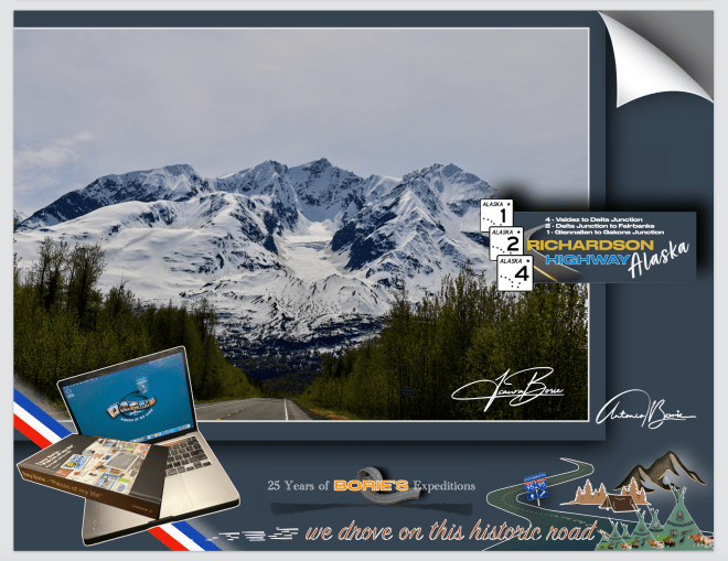
…a caminho da cidade de Valdez, no Centro de Visitas, a uma pergunta nossa, o amável funcionário explicou que não era lá muito recomendável viajar pelo desvio de estrada, com um piso onde frequentemente aparece terra e cascalho e, também era um pouco difícil caminhar nas magníficas trilhas do Wrangell-St. O Elias National Park & Preserve que é, sem qualquer dúvida, o maior e mais magnífico dos vastos parques nacionais do Alaska, com nove dos 16 picos mais altos dos USA!.
…on the way to the city of Valdez, at the Visitor Center, when asked by us, the kind employee explained that it was not very advisable to travel along the road detour, with a surface where dirt and gravel often appear, and that it was also a little difficult to walk on the magnificent trails of the Wrangell-St. Elias National Park & Preserve is, without a doubt, the largest and most magnificent of Alaska’s vast national parks, with nine of the 16 highest peaks in the USA!.
…no entanto não resistimos!. E sabendo nós que a Estrada de Richardson, derivado à área por onde passa, é aquela que recebe níveis épicos de neve no inverno, eser considerada o “lugar onde cai mais neve nos USA”, saímos aproximadamente na milha 106, em Copper Center e lá fomos caminhando por algum tempo nesta grandiosa região montanhosa na fronteira com o Canadá que contém inúmeros glaciers, lagos e córregos da montanha e…, também é o lar de uma rica variedade de vida selvagem!. Fomos apreciando ao longe até onde nos foi possível mas, vêem-se picos sobre picos e glaciers após glaciers, acreditando que, se flutuar-mos por qualquer rio ou ribeiro seguindo até a sua fonte, com toda a certeza que iríamos encontrar um qualquer glacier derretendo-se lentamente!.
…however we couldn’t resist! And knowing that the Richardson Road, derived from the area it passes through, is one that receives epic levels of snow in winter, and is considered the “most snowfall in the USA”, we left at approximately mile 106, in Copper Center and there we walked for some time in this magnificent mountainous region on the border with Canada that contains numerous glaciers, lakes and mountain streams and…, is also home to a rich variety of wildlife!. We appreciated as far as we could, but we saw peaks upon peaks and glaciers after glaciers, believing that, if we floated down any river or stream following to its source, we would certainly find some glacier slowly melting!.
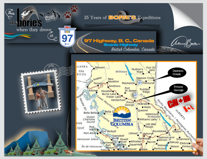
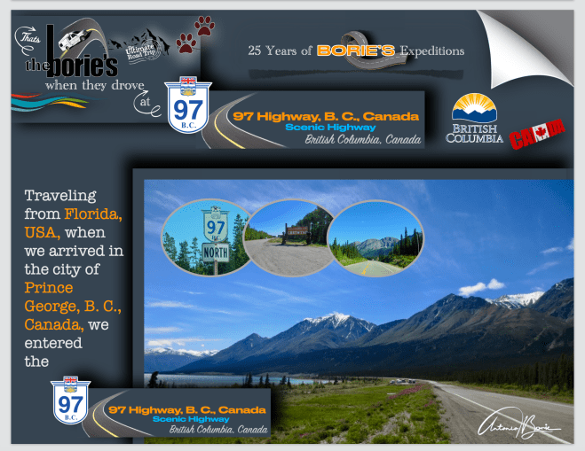
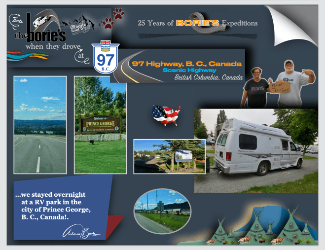
…tínhamos passado a noite num parque de RV na cidade de Prince George, British Columbia, Canada, uma cidade situada junto aos rios Fraser e Nechako, onde as suas origens são referentes a um posto de comércio de peles da North West Company de Fort George, por Simon Fraser, que aqui se estabeleceu por volta do ano de 1807, e o nome foi dado em homenagem ao rei George III!. O posto de comércio de peles, foi centrado na pátria centenária da Primeira Nação Lheidli T’enneh, cujo nome significa “pessoas da confluência dos dois rios”!.
…we had spent the night in an RV park in the city of Prince George, British Columbia, Canada, a city located along the Fraser and Nechako rivers, where its origins refer to a fur trading post of the North West Company of Fort George, by Simon Fraser, who settled here around 1807, and was named in honor of King George III!. The fur trading post was centered on the centuries-old homeland of the Lheidli T’enneh First Nation, whose name means “people of the confluence of the two rivers”!.
…o nosso destino era o norte!. Como tal, o dia ainda não tinha clareado e já estávamos a viajar no Highway 97, no sentido norte!. Esta estrada é a rota mais longa continuamente na província da Columbia Britânica e a maior estrada provincial em qualquer outra província, contudo nós queríamos chegar apenas até à cidade de Dawson Creek!.
…our destination was the north!. As such, the day had not yet lightened and we were already traveling on Highway 97, heading north!. This road is the longest continuously route in the province of British Columbia and the longest provincial road in any other province, yet we only wanted to get as far as the town of Dawson Creek!
…esta estrada está dividida em diversas seções, e passa através de uma região quase selvagem e em grande parte despovoada, que segue por entre montanhas, planícies e lagos, levando o número da rota 97 dos USA, com a qual se conecta na fronteira internacional, e inicialmente foi designada como “97”, no ano de 1953!.
…this road is divided into several sections, and passes through an almost wild and largely unpopulated region, which runs between mountains, plains and lakes, bearing the number of US route 97, with which it connects at the international border, and was initially designated as “97”, in 1953!.
…por exemplo, começámos por viajar na secção John Hart!. Este trecho de aproximadamente 405 km de extensão (252 milhas) da Estrada 97, nome dado pelo ex-primeiro ministro britânico John Hart, que começa em Prince George!.
...for example, we started by traveling in the John Hart! section. This approximately 405 km long (252 miles) stretch of Highway 97, named by former British Prime Minister John Hart, begins in Prince George!.
…depois, viajando por 152 km (94 milhas) ao norte através da pequena aldeia de Summit Lake, que está situado no Continental Divide, bem como através do Parque Provincial Crooked River, Bear Lake e McLeid Lake, até ao seu cruzamento com a Estrada 39!.
…then traveling 152 km (94 miles) north through the small village of Summit Lake, which is situated on the Continental Divide, as well as through Crooked River Provincial Park, Bear Lake and McLeid Lake, to its intersection with Highway 39!.
…e continuando a viajar para nordeste mais 150 km (93 mi), através da Continental Divide, em que ponto o fuso horário muda de Hora do Pacífico, para o Tempo da Montanha!.
…and continuing to travel northeast another 150 km (93 mi), across the Continental Divide, at which point the time zone changes from Pacific Time, to Mountain Time!.
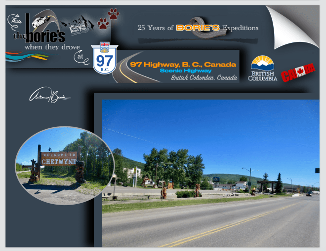
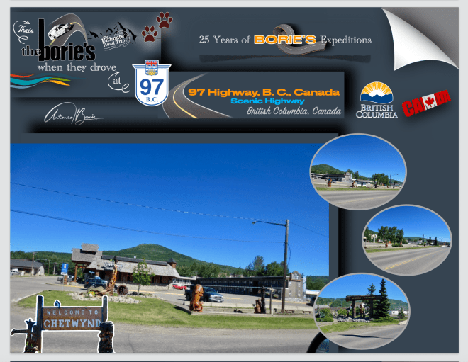
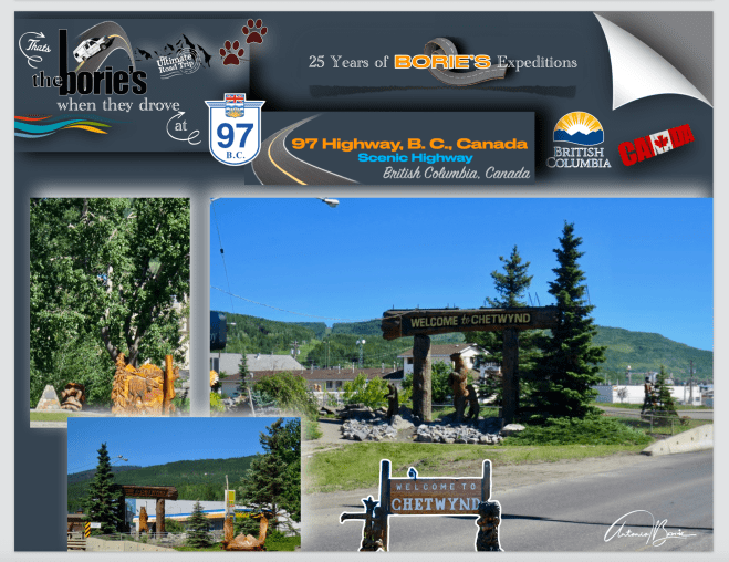
…depois de sair do Pine Pass, e viajando pela Estrada 29, chegamos à cidade de Chetwynd, onde parámos.
…after leaving Pine Pass, and traveling along Route 29, we arrived at the town of Chetwynd, where we stopped!.
…paramos em Chetwynd por duas razões, a primeira foi apreciar as obras de arte em madeira que se espalham ao longo da Estrada 97, que nos dizem que Chetwynd é a pequena comunidade mais habitável da Columbia Britânica, de acordo com um grupo, a silvicultura, a mineração, o processamento de gás natural, a pecuária, a agricultura e a energia eólica são as principais indústrias!.
…we stopped in Chetwynd for two reasons, the first was to appreciate the wooden artwork that dots along Highway 97, which tells us that Chetwynd is the most livable small community in British Columbia, according to one group, forestry, mining, natural gas processing, ranching, agriculture and wind energy are the main industries!.
…e a segunda razão, foi a mudança de óleo na nossa “White Fox” (caravana),que se queixava que já tinha as milhas suficientes e, necessitava de novo óleo!.
…and the second reason was the oil change in our “White Fox” (caravan), which complained that it already had enough miles and needed new oil!.
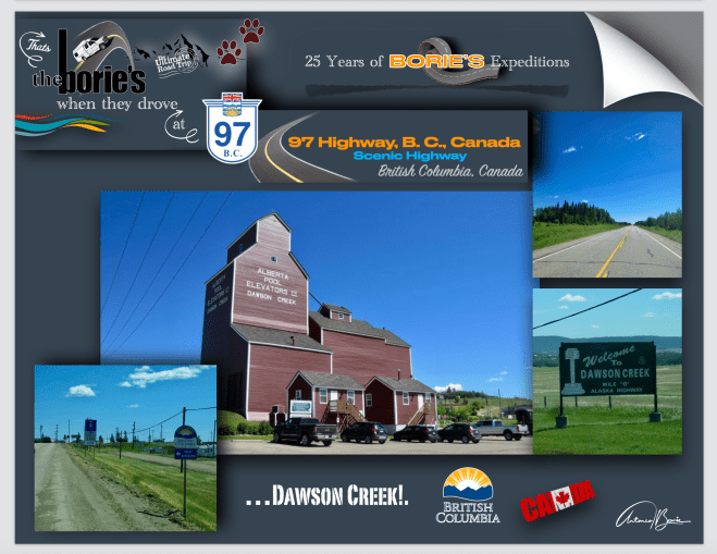
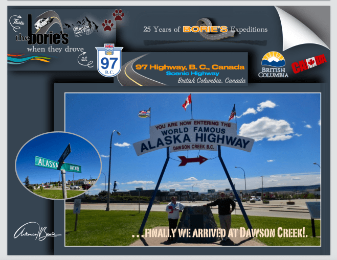
…e após um percurso de outros 97 km (60 mi) para leste, a estrada John Hart, finalmentetermina em Dawson Creek, que é uma típica cidade cujo nome deriva dum riacho que por ali passa com o mesmo nome, que por sua vez o recebeu de um tal George Mercer Dawson, que era um membro de uma equipe de pesquisa de terras, que talvez tal como nós, também por aqui passou no longínquo ano de 1879!.
…and after a journey of another 97 km (60 mi) to the east, the John Hart road finally ends in Dawson Creek, which is a typical town whose name derives from a stream that passes through there with the same name, which in turn received it from a certain George Mercer Dawson, who was a member of a land survey team, who perhaps like us, also passed through here in the distant year of 1879!.
…e foi aqui, quando ainda era uma pequena comunidade agrícola, que se tornou num centro regional, após o terminal ocidental da “Northern Alberta Railways”, ser estendido até aqui, no ano de 1932, crescendo rapidamente quando por volta do ano de 1942, o Exército dos EUA usou este terminal ferroviário como um ponto de transbordo, durante a construção do hoje lendário e “Histórico Alaska Highway”!. Passou então a ser chamada de “Capital da Paz”, também conhecida como a “Milha 0”, referindo-se à sua localização no extremo sul desta já referida estrada!.
…and it was here, when it was still a small agricultural community, that it became a regional center, after the western terminal of the “Northern Alberta Railways”, was extended here in 1932, growing rapidly when around 1942, the US Army used this railway terminal as a transfer point, during the construction of the now legendary and “Historic Alaska Highway”!. It then came to be called the “Capital of Peace”, also known as “Mile 0”, referring to its location at the southern end of this aforementioned road!.
…pela manhã, o tempo era de chuva miudinha com algumas abertas e…, o frio ia desaparecendo de acordo como nos íamos aproximando do paralelo 48º, ou seja, do sul!. Como tal, viajando mais uma vez na hoje famosa e “Histórica Alaska Highway”, agora no sentido leste, ou seja, em direção à cidade de Dawson Creek, na província de British Columbia!. Íamos também contando as milhas no contador da nossa “White Fox” (caravana)!.
…in the morning, the weather was light rain with some rain and…, the cold disappeared as we approached the 48th parallel, that is, from the south!. As such, traveling once again on the now famous and “Historic Alaska Highway”, now in an easterly direction, that is, towards the city of Dawson Creek, in the province of British Columbia!. We were also counting the miles on the meter of our “White Fox” (caravan)!.
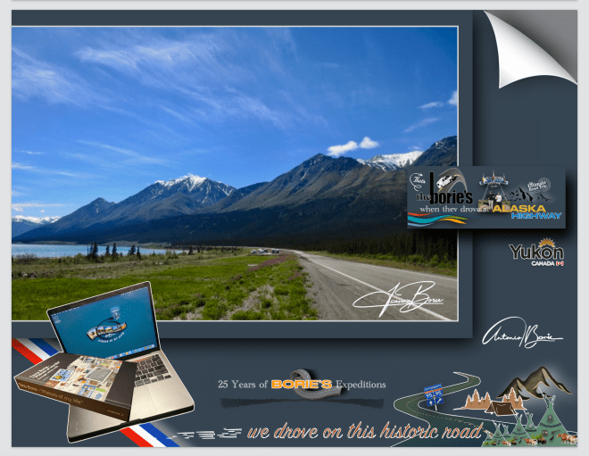
…as milhas e milhas ia passando e…, o tempo ia melhorando!. Já havia algum sol e algumas nuvens brancas, mesmo raras, que tentavam encobrir um adorável céu azul!. Continuávamos a bendizer a sorte, porque o cenário era magnífico para fotos!. Como tal fomos fotografando as montanhas junto do Lago Kluane!.
…the miles and miles went by and…, the weather got better!. There was already some sun and some white clouds, even rare, that tried to cover up a lovely blue sky!. We continued to bless our luck, because the scenery was magnificent for photos! As such, we photographed the mountains next to Lake Kluane!.
…este é o maior lago localizado inteiramente na província do Yukon, e tem aproximadamente 160 milhas quadradas e 50 milhas de comprimento, sendo até agora alimentado pelo A’ay Chu (rio Slims), que era composto de água do derretimento da montanha de gelo de Kaskawulsh, localizada no Parque Nacional de Kluane, desaguando para o Rio Kluane, cujas águas fluem para o rio Donjek, rio Branco, rio Yukon e eventualmente o mar de Bering!.
…this is the largest lake located entirely in the province of Yukon, and is approximately 160 square miles and 50 miles long, being hitherto fed by the A’ay Chu (Slims River), which was composed of meltwater from the ice mountain of Kaskawulsh, located in Kluane National Park, flowing into the Kluane River, whose waters flow into the Donjek River, White River, Yukon River and eventually the Bering Sea!.