…hoje, o nome de Route 66, é aprimorado pelo volume sem precedentes de músicas, livros, filmes e outras formas de arte que a descrevem como a essência da cultura de estradas dos USA!. Na época da sua inauguração, logo se tornou a estrada preferida para oeste, tornando uma nação em movimento, rapidamente ganhando fama como a rota mais curta, onde se podia viajar durante todo o ano entre o Centro-Oeste e a costa, atravessando a lendária paisagem deste país, que é o Sudoeste americano!.
…today, Route 66’s name is enhanced by the unprecedented volume of songs, books, films and other art forms that describe it as the essence of American road culture!. At the time of its inauguration, it soon became the preferred road to the west, making a nation on the move, quickly gaining fame as the shortest route, where one could travel year-round between the Midwest and the coast, crossing the legendary landscape of this country, which is the American Southwest!.
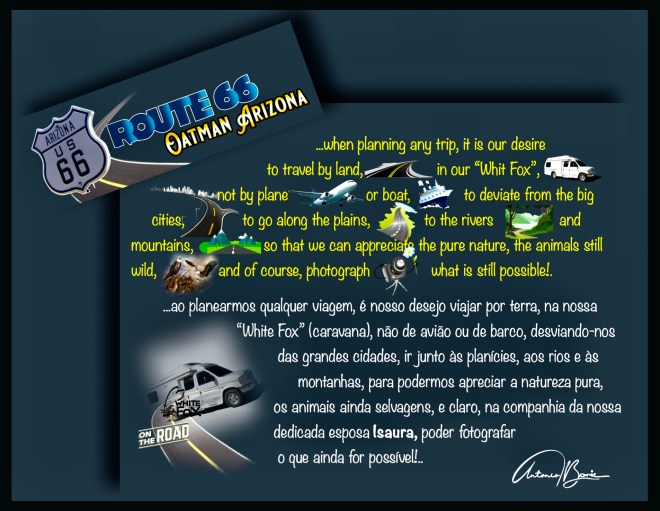
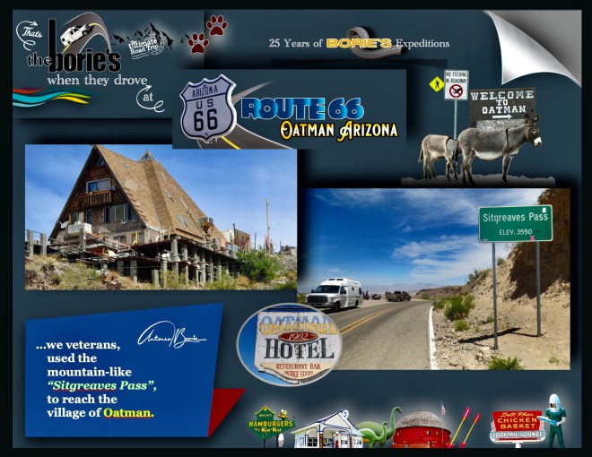
…e, para exemplificar um pouco do cenário da nossa passagem pela rota desta famosa estrada pelo estado do Arizona, vamos descrever, a aventura de viajar pelo “Sitgreaves Pass”, que é uma passagem, onde se forma um pequeno desfiladeiro, a uma altitude de 3.586 pés / 1.093 metros, nas Montanhas Negras do Condado de Mohave, Arizona!.
…and, to exemplify a little bit of the scenery of our passage through the route of this famous highway through the state of Arizona, we will describe the adventure of traveling on the “Sitgreaves Pass”, which is a passage, where a small gorge forms, at an altitude 3,586 feet / 1,093 meters in the Black Mountains of Mohave County, Arizona!.
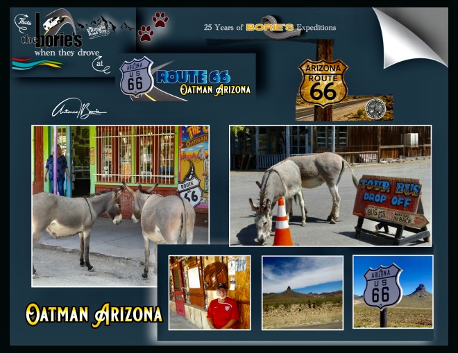
…cruzar as montanhas negras de Mohave, era a única maneira de chegar à aldeia de Oatman, que é uma antiga aldeia de mineração, tal como os viajantes que em tempos usaram a hoje Histórica Estrada 66, localizada numa elevação de 2700 ft / 896m, começando como um acampamento de barracas, logo depois que dois prospectors encontraram um achado de ouro de $10 milhões por volta do ano de 1915, embora a área tivesse sido estabelecida já por alguns anos!.
…crossing the black mountains of Mohave, was the only way to reach the village of Oatman, which is an old mining village, just like the travelers who once used the now Historic Highway 66, located at an elevation of 2700 ft / 896m, starting as a tent camp, shortly after two prospectors found a $ 10 million gold find around 1915, although the area had already been established for a few years!.
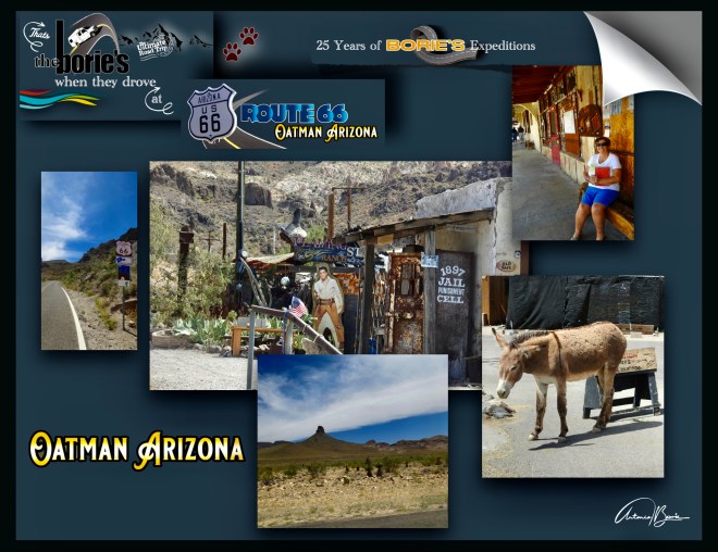
…com este achado de ouro, no decurso de aproximadamente um ano a sua população cresceu para mais de 3.500 e, os “Burros Selvagens”, que hoje vimos passearem pelas ruas da aldeia de Oatman, são os descendentes de burros trazidos para aqui pelos primeiros mineiros de ouro nos anos de 1800, quando os mineiros desanimados com a sua prospecção, deixaram a aldeia e foram soltos!.
…with this golden find, in the course of approximately one year its population grew to over 3,500 and the “Wild Donkeys”, which we saw today strolling through the streets of the village of Oatman, are the descendants of donkeys brought here by the first gold miners in the 1800s, when the miners, discouraged by their prospecting, left the village and were released!.
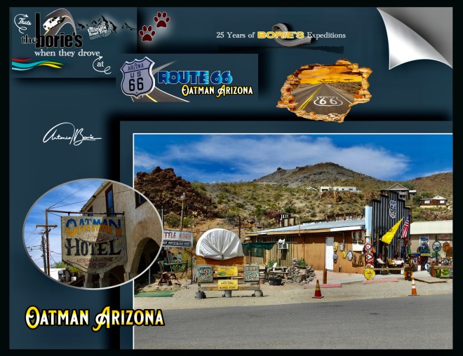
…aqui, passámos algum tempo, admirando com algum pormenor todo este espólio da Histórica Estrada 66, que continua com algum grau de conservação!.
…were, we spent some time, admiring in some detail all this collection of Historic Estrada 66, which continues with some degree of conservation!.
…enfim, andar por aqui é como dar um passo atrás para um tempo mais simples, lembrando a hoje Histórica Route 66, despida de suas placas e removida dos mapas das estradas, que vai renascendo, quando parecia destinada a se tornar uma nota de rodapé esquecida na história, onde quase 2.500 milhas de calçada, o grande corredor de néon, estava desbotado, menos percorrido e, em alguns lugares, mais difícil de encontrar, mas ainda está lá, esperando ser redescoberto!.
…so, walking around here is like taking a step back to a simpler time, remembering today Historic Route 66, stripped of its plates and removed from the road maps, which is reborn when it seemed destined to become a note footer forgotten in history, where almost 2,500 miles of sidewalk, the great neon corridor, was faded, less traveled and, in some places, more difficult to find, but it is still there, waiting to be rediscovered!.
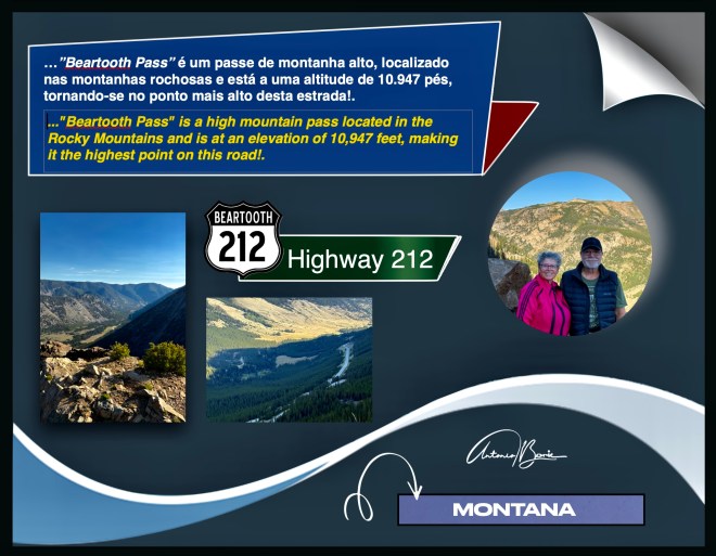
…a Estrada Beartooth, estende-se por aproximadamente 68 milhas ao longo da Rota 212 dos EUA!. Esta estrada icónica, aberta somente alguns meses no verão com bom tempo, pois devido à sua elevação e às duras condições de inverno, a Estrada Beartooth, geralmente está aberta apenas do final de Maio a meados de Outubro, dependendo da queda de neve!. Conecta a cidade de Red Lodge, Montana, até à entrada nordeste do Parque Nacional de Yellowstone, em Wyoming, todavia podemos seguir nela até à entrada norte do já referido Parque Yellowstone, na Silver Gate, em Montana, e felizmente foi o que fizemos!.
…Beartooth Road extends to approximately 68 miles along the US Route 212!. This iconic road, opened only a few months in summer with a good time, because due to its elevation and the harsh winter conditions, the Beartooth Road is usually open from late May to mid -October, depending on snowfall!. Connects the city of Red Lodge, Montana, to the northeast entrance of Yellowstone National Park in Wyoming, but we can continue to it to the north entrance of the Yellowstone Park in Silver Gate, in Montana, and fortunately that’s what we did!.
…também é conhecida como “A estrada mais bonita da America”, sobe a uma elevação de quase 10.947 pés no “Beartooth Pass, (onde estivemos e…, como adoramos caminhar, na companhia da nossa dedicada esposa Isaura, fizemos um passeio numa pequena trilha de aproximadamente meia milha, e nesta já um pouco avançada idade, felizmente sem qualquer sintoma fora do normal), tornando-a a rodovia pavimentada mais alta das Montanhas Rochosas do Norte!.
… It is also known as “the most beautiful road in America”, rises to a rise of almost 10,947 feet on the “Beartooth Pass”, (where we were and …, as we love to walk, in the company of our dedicated wife Isaura, we took a walk in a small trail of approximately half a mile, and in this one a little age, fortunately without any unusual symptoms), making it the highest roller coast from the north!.
…a sua rota oferece-nos inúmeras retiradas para trilhas e caminhadas, tal como oportunidades de fotos, incluindo vistas espetaculares como o Beartooth Pass Vista Point!. Para os viajantes que vão para Yellowstone, serve como uma introdução dramática à beleza selvagem do ecossistema do Grande Yellowstone, tornando-a uma experiência obrigatória para quem explora o Oeste Americano!.
… Its route offers us numerous withdrawals for trails and hiking, such as photo opportunities, including spectacular views like Beartooth Pass Vista Point!. For travelers who go to Yellowstone, it serves as a dramatic introduction to the wild beauty of the great Yellowstone ecosystem, making it a mandatory experience for those who explore the West American!.
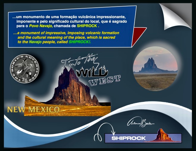
…continuando, e como o final do dia se aproximava, já viajando em direção ao leste, ou seja, entrando no estado de Novo Mexico, ainda a milhas de distância e com o sol a esconder-se, nós conduzindo e a nossa dedicada esposa Isaura ia fotografando um monumento de uma formação vulcânica impressionante, imponente e pelo significado cultural do local, que é sagrado para o Povo Navajo, chamada de Shiprock!.
…continuing, and as the end of the day was approaching, already traveling towards the east, that is, entering the state of New Mexico, still miles away and with the sun hiding, we lead and our dedicated wife Isaura was photographing a monument of impressive, imposing volcanic formation and the cultural meaning of the place, which is sacred to the Navajo people, called SHIPROCK!.
…onde é proibido escalar, fazer caminhadas ou chegar à base do Shiprock, pois é um local sagrado, e os visitantes devem respeitar o seu significado cultural. No entanto, de estradas próximas, vale a pena visitar, ver e fotografar o monumento que serve como um marco marcante na região de quatro cantos do Novo México, embora o acesso direto à formação seja restrito para se proteger o seu estado sagrado!.
…where it is forbidden to climb, walk or reach the base of Shiprock, as it is a sacred place, and visitors must respect its cultural meaning!. However, from nearby roads, it is worth visiting, seeing and photographing the monument that serves as a remarkable milestone in the region of four corners of New Mexico, although direct access to training is restricted to protect its sacred state!.
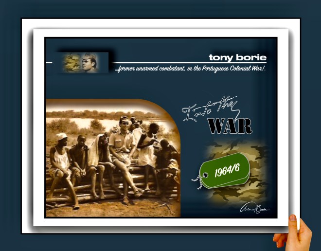
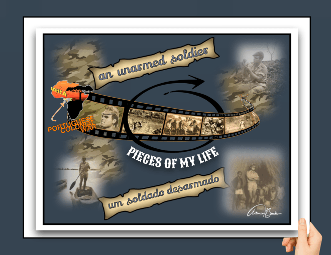
…também lá havia o companheiro “Curvas” do Pelotão de Morteiros!. Era assim carinhosamente chamado por ser alto e caminhar curvado!. Todos diziam que devia de ser “General”, porque era refilão, com alguma indisciplina e não acatava ordens mas…, era um verdadeiro soldado, combativo e com desprezo pela vida, sempre em favor dos companheiros que sempre protegeu em cenário de combate, sendo agraciado com a “medalha cruz de guerra de segunda classe”, que lhe foi entregue lá no aquartelamento, porque declinou vir a Lisboa, Portugal, recebê-la, dizendo que não tinha lá família, pois a sua família estava ali consigo, que éramos nós!.
…there was also the companion “Curvas” from the Mortar Platoon there!. He was affectionately called that because he was tall and walked hunched over!. Everyone said that he should be a “General”, because he was rebellious, with some indiscipline and did not follow orders but…, he was a true soldier, combative and with a disregard for life, always in favor of his comrades who he always protected in a combat scenario, being awarded the “second class war cross medal”, which was given to him there in the barracks, because he declined to come to Lisbon, Portugal, to receive it, saying that he had no family there, as his family was there with him, that it was us!.
…a sua mãe era oriunda duma província do interior montanhoso do centro de Portugal e ele, nunca recebeu qualquer carta ou aerograma durante os seus dois anos de estadia em Mansoa, lá no golfo da Guiné, pela razão já acima mencionada, de não ter família, porque tinha sido abandonado pela mãe ainda criança, que “foi vendida ou talvez de encomenda para servir em Lisboa” e…, infelizmente “andava na vida” (prostituição),e ele, ao “Deus dará”, sem nunca ter tido ninguém que lhe limpasse o ranho do nariz, já tinha visitado por diversas vezes os calabouços da esquadra da polícia por pequenos delitos, sabia roubar uma carteira sem o seu verdadeiro dono o notar, aquilo que era o sofrimento da fome e dormir na rua e…, tendo assim alguma experiência do que “era o bem e o mal”!.
…his mother came from a province in the mountainous interior of central Portugal and he never received any letter or aerogram during his two years of stay in Mansoa, there in the Gulf of Guinea, for the reason already mentioned above, of not having a family, because he had been abandoned by his mother as a child, who “was sold or perhaps ordered to serve in Lisbon” and…, unfortunately “he was living in life” (prostitution), and he, “God will give”, without ever having anyone to help him He could wipe the snot from his nose, he had already visited the police station dungeons several times for petty crimes, he knew how to steal a wallet without its real owner noticing, what it was like to suffer from hunger and sleep on the street and…, thus having some experience of what “good and evil were”!.
…naquela época era normal, as mães mulheres da província que trabalhavam de sol a sol e esperavam a sorte de alguém levar uma das suas filhas para a cidade, “servir” para casa de gente de posses, sempre seria menos uma malga de caldo que se poupava e algum dinheiro que devia chegar pelo correio no final de cada mês, só que…, esta jovem mulher sua mãe, com os braços cansados de dar colo aos irmãos mais novos e de rodilha na cabeça para aguentar o peso dos molhos de erva ou de lenha…, lá na cidade de Lisboa, talvez sentindo-se abandonada, entrou no circulo da “vida fácil”, que…, não devia de ser nada fácil!.
…at that time it was normal, women mothers from the province who worked from sunrise to sunset and waited for someone to take one of their daughters to the city, “serve” in the homes of people of means, there would always be less of a bowl of broth that was saved and some money that should arrive in the mail at the end of each month, but…, this young woman, her mother, with her arms tired of holding her younger brothers and with a wheel on her head to support the weight of bundles of grass or firewood…, there In the city of Lisbon, perhaps feeling abandoned, she entered the circle of the “easy life”, which…, shouldn’t be easy at all!.
…e ele, o companheiro “Curvas”, quando se distribuía o correio, como nunca mencionavam o seu nome, simplesmente ia sozinho com o púcaro do café cheio de vinho, para de baixo da enorme árvore de manga, junto do pequeno pântano na parte leste do aquartelamento em construção, onde havia as gaiolas dos macacos, e piriquitos e…, não falava com ninguém!.
…and he, the “Curvas” companion, when the mail was distributed, as his name was never mentioned, he simply went alone with the coffee pot full of wine under the huge mango tree, next to the small swamp in the eastern part of the barracks under construction, where there were the monkey cages, and parakeets and…, he didn’t talk to anyone!.
…nós, sempre o ouvimos e o considerávamos um companheiro amigo que dormia debaixo do mesmo cabanal, e ele, sentia alguma confiança em nós ao ponto de quando saía em patrulha ou operações com o seu grupo de combate, normalmente, entregava-nos a saca feita de meia manga, cortada do camuflado em farrapos, com alguns bens, como um “terço” com uma pequena Cruz de Cristo, a fotografia amarelada da avó, o relógio, algum dinheiro e outros objectos, com a recomendação de os guardar!.
…we always listened to him and considered him a friendly companion who slept under the same hut, and he felt some trust in us to the point that when he went out on patrol or operations with his combat group, he would normally give us his bag made from half a sleeve, cut from the camouflage in tatters, with some goods, such as a “chaplet” with a small Cross of Christ, his grandmother’s yellowed photograph, his watch, some money and other objects, with the recommendation to keep them!.
…para nós, o “Curvas” já não era um companheiro militar, era um GUERREIRO, era um homem de combate, que tinha os seus regulamentos internos porque já conhecia a dor de ver o sangue quente a sair do corpo de um companheiro ferido em combate e…, às vezes, quando haviam pequenas zangas no cabanal, os ânimos exaltavam-se e havia uma barafunda, com alguns a acalmarem outros, no entanto…, quando saíam para o interior das selvas e pântanos em patrulha ou para desactivarem alguma base de guerrilheiros, eram amigos e solidários, protegiam-se, davam a vida uns pelos outros, eram verdadeiros irmãos de sangue!.
…for us, “Curvas” was no longer a military companion, he was a WARRIOR, he was a man of combat, who had his internal regulations because he already knew the pain of seeing the hot blood leaving the body of a comrade wounded in combat and…, sometimes, when there were small fights in the hut, tempers flared up and there was a commotion, with some calming others, however…, when they went out into the jungles and swamps on patrol or to deactivate Some guerrilla base, they were friends and supportive, they protected each other, they gave their lives for each other, they were true blood brothers!.
…nós, um soldado desarmado, somos sobreviventes da maldita Guerra Colonial Portuguesa, uma guerra horrorosa, que anos depois se verificou que era injusta, que não desejamos, em nenhuma circunstância, se volte a repetir, mas não resistimos em mencionar algumas passagens de relatos de textos onde falamos principalmente da mulher mãe, portanto cá vai:
“Na aldeia havia somente uma mulher, magra, já de uma certa idade, nua da cinta para cima, com algumas argolas em volta do pescoço, servindo de enfeite, talvez!. Ela se lastimava, por os militares lhe terem morto os seus dois filhos, e diz para se irem embora, que aqui não há mais ninguém. Também diz que tem quatro filhas, que desapareceram um certo dia pela madrugada, e que as visitam de vez em quando, pois neste momento eram guerrilheiras, transportadoras de material de guerra!. Na sua frente, estavam duas crianças, também magras e nuas”!.
…we, an unarmed soldier, are survivors of the cursed Portuguese Colonial War, a horrible war, which years later it turned out to be unfair, which we do not wish, under any circumstances, to repeat, but we couldn’t resist mentioning some passages from text reports where we talk mainly about the woman mother, so here goes:
“In the village there was only one woman, thin, of a certain age, naked from the waist up, with some rings around her neck, serving as an ornament, perhaps!. She was saddened by the fact that the military had killed her two sons, and said to leave, as there is no one else here!. She also says that she has four daughters, who disappeared one day in the early hours of the morning, and that she visits them from time to time, as at that time they were guerrillas, transporting military material. war!. In front of him were two children, also thin and naked”!.
…e agora, outro relato de uma mãe em Portugal, tirado de outro texto:
“Ainda não fui, mas não tarda muito tempo. Sou viúva duas vezes, do meu Joaquim, que Deus lhe guarde a alma em descanso, e do meu António, que era a cara do pai, quando nasceu, e que foi dar o corpo às balas, e que morreu na guerra, lá na África. E mostrava sempre o farrapo do camuflado ensanguentado, que nós lhe mandámos, e a fotografia do António, que beijava e encostava ao coração”.
…and now, another story from a mother in Portugal, taken from another text:
“I haven’t gone yet, but it won’t be long. I’m a widow twice, of my Joaquim, may God keep his soul at rest, and of my António, who was the spitting image of his father, when he was born, and who ended up giving his body to bullets, and who died in the war, there in Africa. And I always showed the rags of the bloody camouflage, which we sent him, and the photo of António, which he kissed and placed against his heart.”
…estes relatos exprimem dor, angústia e sofrimento, da mulher mãe, tanto africana com europeia e acreditamos, que não existe nenhum ser humano, por mais estudos e experiência que tenha, que esteja qualificado para analisar o que ia na mente destes seres humanos, que perderam os seus entes queridos!.
…these reports express pain, anguish and suffering, of the mother, both African and European, and we believe that there is no human being, no matter how many studies and experience he has, who is qualified to analyze what was in the minds of these human beings, who lost their loved ones!.
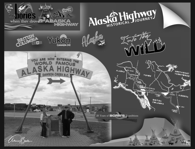
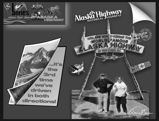
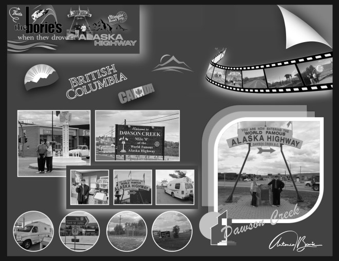
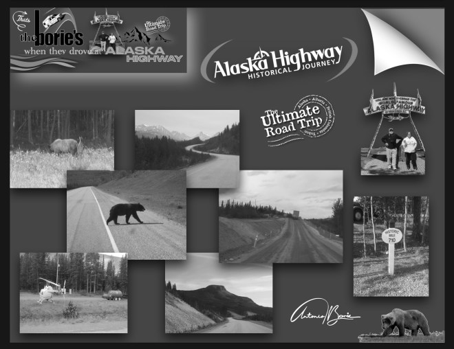
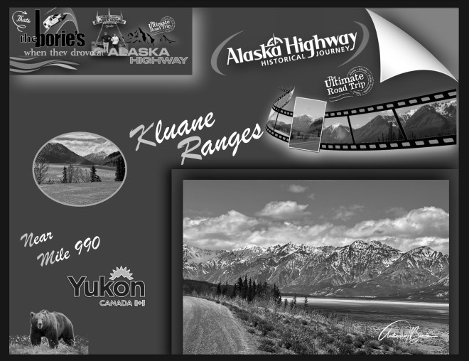
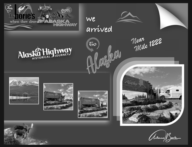
…embora vivendo no estado da Flórida, já algumas vezes aqui mencionámos as nossas aventuras lá pelo norte, depois de ultrapassar o “paralelo 48”, atravessando parte do território do Canadá, incluindo o lendário e histórico “Alaska Highway”, que serpenteia aquelas montanhas, planícies desertas, lagos e rios, das províncias de British Columbia e do Yukon até ao estado do Alaska, onde no período de alguns anos, viajando sempre por terra, por vezes atravessando rios em jangadas, já completámos “três expedições” a este estado!.
…although we live in the state of Florida, we have already mentioned our adventures up north a few times, after crossing the “48th parallel”, crossing part of the territory of Canada, including the legendary and historic “Alaska Highway”, which winds through those mountains, deserted plains, lakes and rivers, from the provinces of British Columbia and Yukon to the state of Alaska, where in the period of a few years, always traveling by land, sometimes crossing rivers on rafts, we have already completed “three expeditions” to this state!
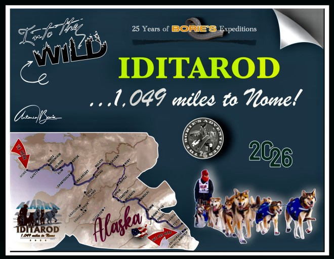
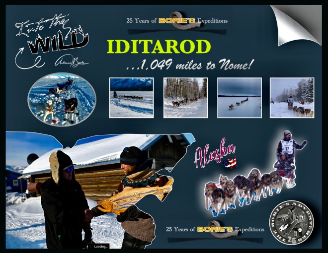
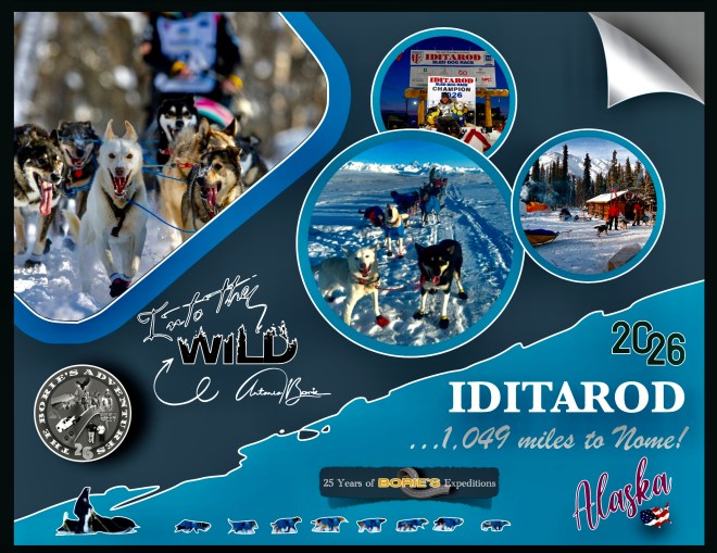
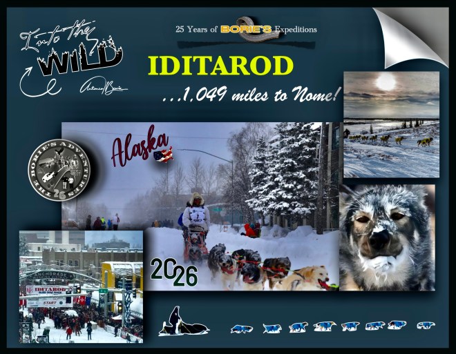
…como tal, é frequente escrever sobre o estado do Alaska e continuar a receber notícias do que por lá se passa!. Vamos recolhendo conteúdos de diversas fontes de informação e da comunicação social, a quem agradecemos as notícias e as fotos, que acompanharam esta histórica corrida, que tomámos a liberdade de construir um arranjo com as fotos e alguns conteúdos e publicar no nosso blog, que este ano deu pelo nome de “Iditarod, 1049 miles to Nome” , ou seja, isto é um pequeno resumo de tudo o que gentilmente nos vão informando, o que muito agradecemos!.
…as such, I often write about the state of Alaska and continue to receive news about what is happening there!. We are collecting content from various sources of information and the media, and we are grateful for the news and photos that accompanied this historic race, which we took the liberty of creating an arrangement with the photos and some content and publishing on our blog, which this year we called “Iditarod, 1049 miles to Nome”, in other words, this is a small summary of everything that you have kindly informed us about, which we are very grateful for!.
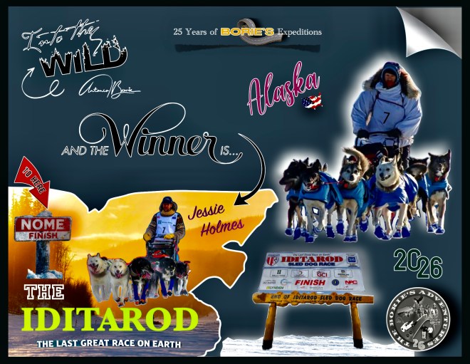
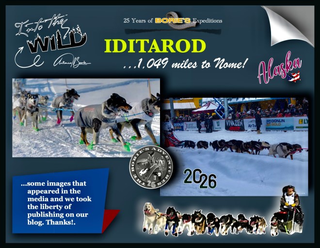
…assim, podemos ler que o “musher” (condutor de um trenó puxado por cães), Jessie Holmes, que para esta histórica corrida levou 16 cães, (em cada etapa usava 12, 13 ou 14), que puxavam o seu trenó, atravessou o “Burled Arch do Iditarod” na distante cidade de Nome, quase ao cair do crepúsculo, passando sob o arco às 21h32, após 9 dias, 7 horas, 32 minutos e 51 segundos, levantando os dois braços enquanto o seu time descia a Front Street sob os aplausos de algumas centenas de fãs reunidos perto da rampa de chegada, continuando a ser o campeão desta histórica corrida de cães de trenó, pois já no ano passado foi ele o vencedor!.
…thus, we can read that the “musher” (driver of a dog sled), Jessie Holmes, who for this historic race took 16 dogs, (in each stage he used 12, 13 or 14), who pulled his sled, crossed the “Burled Arch of the Iditarod” in the distant city of Nome, almost at dusk, passing under the arch at 9:32 pm, after 9 days, 7 hours, 32 minutes and 51 seconds, raising both arms as his team walked down Front Street to the applause of a few hundred fans gathered near the finish ramp, continuing to be the champion of this historic sled dog race, as last year he was the winner!.
…parabéns a Jessie Holmes e à sua equipe de cães, liderada por Zeus, de 3 anos, e Polar, de 8 anos, por vencer o “Iditarod, 1049 miles to Nome”, que no final, e depois de abraçar e distribuir bifes gigantescos pelos seus cães, emocionado disse que: “é uma bênção estar aqui!. Fiquei muito grato e agradecido por ser recebido em todas essas comunidades e por estar em todo este lindo país com a equipe de cães mais incrível que já vi”!.
…congratulations to Jessie Holmes and her team of dogs, led by Zeus, 3 years old, and Polar, 8 years old, for winning the “Iditarod, 1049 miles to Nome”, who at the end, and after hugging and distributing gigantic steaks to her dogs, emotionally said that: “it’s a blessing to be here!. I was so grateful and grateful to be welcomed into all of these communities and to be across this beautiful country with the most amazing team of dogs I have ever seen!”.
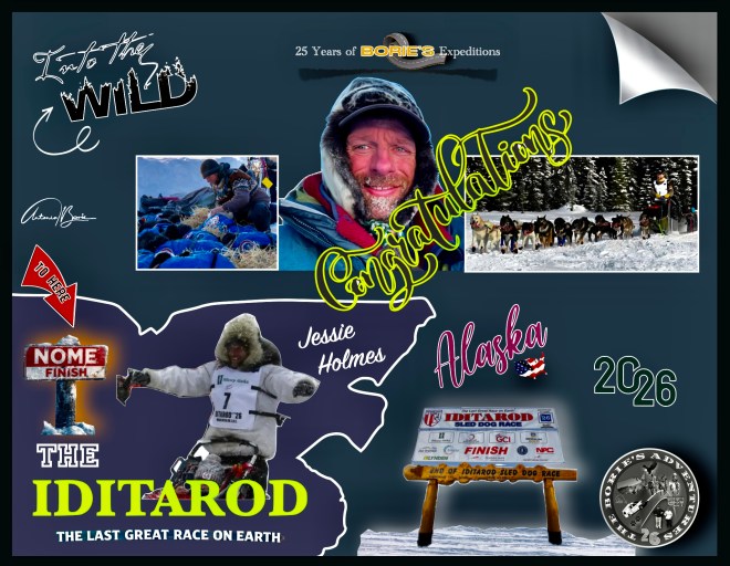
…embora tenha vencido de forma convincente, Holmes disse que ainda teve momentos de extrema dificuldade, incluindo encontrar condições de 40 graus abaixo de zero perto de Bear Creek, nos primeiros dias da corrida, no entanto e continuando, disse ainda: “Isso apenas prova que você não está competindo!. Você está correndo com os seus cães, fazendo o que é melhor para eles, e você tem que se ajustar à Mãe Natureza, porque ela governa e vai-nos humilhar, por mais orgulhosos que sejamos e por mais duros que nos sintamos, também nos sentimos muito humildes agora, e muito abatidos e derrotados, porque ela, a Mãe Natureza, é que vence”!.
…although he won convincingly, Holmes said he still had moments of extreme difficulty, including encountering conditions of 40 degrees below zero near Bear Creek, in the early days of the race, however, and continuing, he said: “It just proves that you’re not competing!. You’re running with your dogs, doing what’s best for them, and you have to adjust to Mother Nature, because she rules and will humble us, and as proud as we are and as tough as we feel, we also feel very humble now, and very dejected and defeated, because she, Mother Nature, wins”!.
…mas, vamos explicar um pouco o que é o “Iditarod, 1049 miles to Nome”?. É uma corrida anual de Cães de Trenó de longa distância, a exemplo do que foram a “Santa Fé Trail”, a “Oregon Trail”, a “Califórnia Trail”, a “Appalachian Trail” ou a “Mormon Trail”, (trilhas antigas dos pioneiros, das quais já tivemos o privilégio de percorrer alguns pequenos troços do seus percursos) e, a sua distância varia de ano para ano, mas oficialmente a rota tem à volta de 1.100 milhas de comprimento!
…but, let’s explain a little what the “Iditarod, 1049 miles to Nome” is? It is an annual long-distance Sled Dog race, like the “Santa Fé Trail”, the “Oregon Trail”, the “California Trail”, the “Appalachian Trail” or the “Mormon Trail”, (old pioneer trails, of which we have had the privilege of traveling some small sections of their routes) and, its distance varies from year to year, but officially the route is around 1,100 miles long!..
…e lá no estado do Alaska, onde já estivemos em alguns lugares estratégicos junto do seu percurso, embora sendo época de verão, portanto com pouca neve, caminhando por pequenos troços que fazem parte do que foi a história de pioneiros, que no século XIX, atravessaram não só planícies na procura da sua terra prometida, como também a “tundra” (região ártica, plana e sem árvores com o subsolo permanentemente congelado), próximo do Mar de Bearing, à luz do “sol da meia-noite”!.
…and there in the state of Alaska, where we have already been to some strategic places along its route, although it is summer time, therefore with little snow, walking along small sections that are part of what was the history of pioneers, who in the 19th century, crossed not only plains in search of their promised land, but also the “tundra” (Arctic region, flat and treeless with the subsoil permanently frozen), close to the Bearing Sea, in the light of the “midnight sun”!.
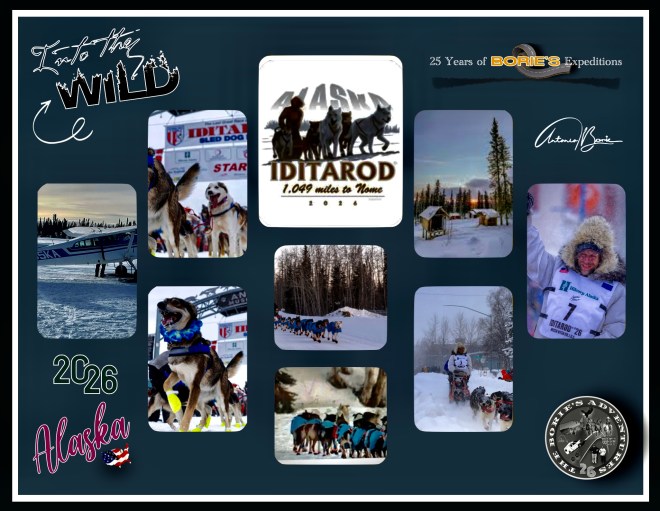
…este evento começou no ano de 1973, como sendo um evento para testar os melhores “mushers” com as suas equipes de cães de trenó, mas evoluiu para a corrida altamente competitiva de hoje, onde este ano dá pelo pomposo nome de “Iditarod, 1049 miles to Nome” e, não é mais do que uma homenagem ao que faziam os pioneiros pesquisadores de ouro do século dezoito ou dezanove, que se aventuravam para leste, quando desembarcavam na cidade de Nome, no Mar de Bearing!.
…this event began in 1973, as an event to test the best “mushers” with their teams of sled dogs, but has evolved into the highly competitive race of today, where this year goes by the pompous name of “Iditarod, 1049 miles to Nome” and is nothing more than a tribute to what the pioneering gold researchers of the eighteenth or nineteenth century did, who ventured east, when they disembarked in the city of Nome, in Sea of Bearing!.
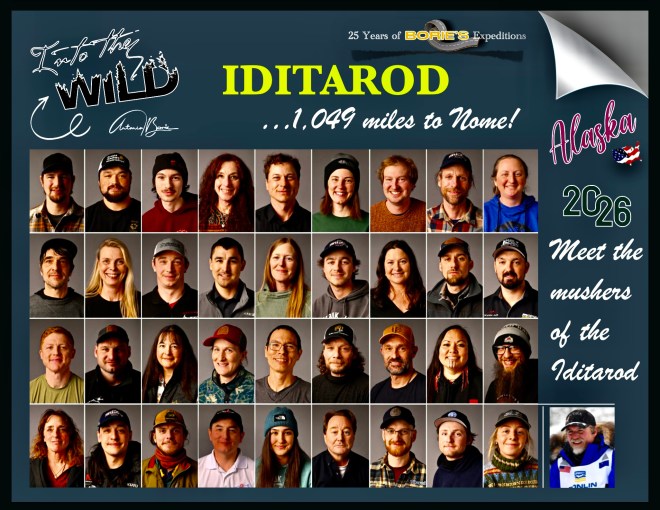
…este ano, realizou-se a 54ª corrida, que também chamam da “última grande corrida na Terra” e que à partida incluiu 37 “mushers”, alguns internacionais!. Estes “mushers”, são condutores de cães experientes em terreno gelado, enfrentando uma cansativa jornada de mais de 1.000 milhas num terreno áspero e selvagem do Alaska, incluindo o rio Yukon congelado, o traiçoeiro gelo do Mar de Bering e duas cadeias de montanhas distintas!. Também encontram riscos ambientais adicionais que incluem ventos fortes, possíveis nevascas e frio extremo que colocam tanto os condutores quanto seus cães de trenó em alto risco de queimaduras pelo frio!.
…this year, the 54th race took place, which they also call the “last great race on Earth” and which initially included 37 “mushers”, some international!. These “mushers” are experienced dog handlers in icy terrain, facing a grueling journey of more than 1,000 miles through harsh, wild Alaskan terrain, including the frozen Yukon River, the treacherous ice of the Bering Sea and two distinct mountain ranges! They also encounter additional environmental hazards that include high winds, possible blizzards, and extreme cold that place both mushers and their sled dogs at high risk of frostbite!
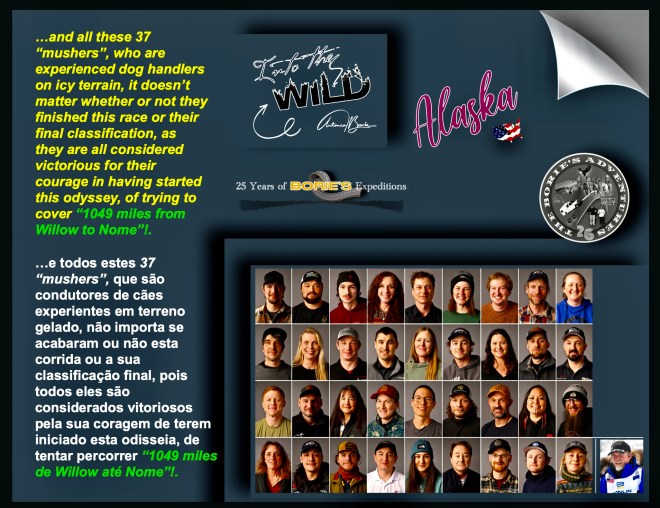
…e todos estes 37 “mushers”, que são condutores de cães experientes em terreno gelado, não importa se acabaram ou não esta corrida ou a sua classificação final, pois todos eles são considerados vitoriosos pela sua coragem de terem iniciado esta odisseia, de tentar percorrer “1049 miles de Willow até Nome”!.
…and all these 37 “mushers”, who are experienced dog handlers on icy terrain, it doesn’t matter whether or not they finished this race or their final classification, as they are all considered victorious for their courage in having started this odyssey, of trying to cover “1049 miles from Willow to Nome”!.
…este ano, esta competição, que no dia 8 de Março, reiniciou oficialmente em Willow, um local localizado a algumas milhas a noroeste da cidade de Wasilla, ao longo da estrada George Parks, embora o seu início cerimonial tivesse ocorrido no centro da cidade de Anchorage, exigindo que os participantes naveguem por esses elementos enquanto gerenciam uma equipe de pelo menos 12 a 14 cães de trenó!.
…this year, this competition, which on March 8, officially restarted in Willow, a location located a few miles northwest of the city of Wasilla along George Parks Road, although its ceremonial start took place in downtown Anchorage, requiring participants to navigate these elements while managing a team of at least 12 to 14 sled dogs!.
…tanto os organizadores como os veteranos, enfatizam que o percurso continua a ser um teste de resistência, onde as equipas também devem enfrentar a exaustão física de viajar a velocidades médias de 7 ou 8 milhas/hora em terrenos gelados, e claro, é notório que a travessia do gelo marinho de Norton Sound que tornou Seppala e Togo tão famosos há um século, onde muitos dos mais experientes “mushers”, vão aproveitar por serem as corridas mais mágicas da trilha, que é o transporte do interior do rio Yukon, através das colinas de Nulato até à costa do Mar de Bering!.
…both organizers and veterans emphasize that the route continues to be a test of endurance, where teams must also face the physical exhaustion of traveling at average speeds of 7 or 8 miles/hour on icy terrain, and of course, it is clear that the crossing of the sea ice of Norton Sound that made Seppala and Togo so famous a century ago, where many of the most experienced “mushers”, will enjoy as they are the most magical races of the trail, which is the transportation of the interior of the river Yukon, through the Nulato Hills to the Bering Sea coast!.
…e todos dias durante esta “última grande corrida no Earth”, havia notícias de como tudo ia decorrendo, por exemplo: o veterano musher, Jessie Holmes foi o primeiro a chegar ao posto de controle McGrath às 20h03, ganhando o prémio Alaska Air Transit Spirit of Iditarod, onde a comunidade McGrath compartilha laços profundos com Iditarod, e o prémio reflete essa conexão, apresentando luvas de pele de castor com miçangas Athabaskan em pele de alce, feitas à mão por Loretta Maillelle de McGrath, junto com um chapéu de pele de castor feito por Rosalie Egrass, também de McGrath!.
…and every day during this “last great race on Earth”, there was news of how it was going, for example: veteran musher, Jessie Holmes was the first to reach the McGrath checkpoint at 8:03 pm, winning the Alaska Air Transit Spirit of Iditarod award, where the McGrath community shares deep ties with the Iditarod, and the award reflects that connection, featuring beaver fur gloves with Athabaskan elk skin beads, made handmade by Loretta Mailllelle of McGrath, along with a beaver fur hat made by Rosalie Egrass, also of McGrath!.
…ou por exemplo: “Paige Drobny está a liderar a corrida para o posto de controle na aldeia de Ruby!. Neste momento ela está a 22 milhas de Ruby!.Jessie Holmes vem a 11 milhas atrás na 2.ª posição!. Algumas equipas estão descansando os cães na trilha, na milha 266!. O clima, agora é de 34 graus e esta noite vai estar nublado com chuviscos de neve a baixo de 23 graus, com ventos de 20 MPH e a chance de neve é de 40%”!.
…or for example: “Paige Drobny is leading the race to the checkpoint in Ruby’s village!. Right now she is 22 miles from Ruby!. Jessie Holmes is 11 miles behind in 2nd position! Some teams are resting their dogs on the trail, at mile 266!. The weather is now 34 degrees and tonight will be cloudy with snow drizzle below 23 degrees, with winds of 20 MPH and the chance of snow is 40%”!.
…outro exemplo: Jessie Holmes chegou ao posto de controle da aldeia de Unalakleet às 9h27 de domingo!. Como recompensa por ser o primeiro a ali chegar, recebeu um mergulhão esculpido à mão feito pelo artista Inupiaq Mark Tetpon e um prémio monetário em pepitas de ouro!.
…another example: Jessie Holmes arrived at the Unalakleet village checkpoint at 9:27 am on Sunday!. As a reward for being the first to arrive there, he received a hand-carved loon made by Inupiaq artist Mark Tetpon and a monetary prize in gold nuggets!.
…outras curiosidades na logística, como por exemplo: “incríveis voluntários, que são a espinha dorsal da “Última Grande Corrida da Terra”, ensacaram, paletizaram e adicionaram postagem a 1.500 fardos de palha na Air Land Transport, Inc. em Anchorage, que foram então enviados para os 22 postos de controle ao longo da Trilha Iditarod até Nome…, palha fresca estará esperando, dando a cada cão um lugar quente, seco e confortável para descansar, porque por aqui, os cães são prioridade!.
…other logistics tidbits, such as: “Amazing volunteers, who are the backbone of the “Last Great Race on Earth,” bagged, palletized and added postage to 1,500 bales of straw at Air Land Transport, Inc. in Anchorage, which were then shipped to the 22 checkpoints along the Iditarod Trail to Nome…, fresh straw will be waiting, giving each dog a warm, dry, comfortable place to rest, because by Here, dogs are a priority!.
.…enfim, isto são curiosidades do estado do Alaska, a última fronteira!.
...anyway, these are interesting facts about the state of Alaska, the last frontier!
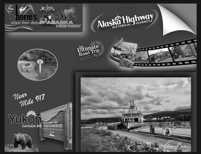
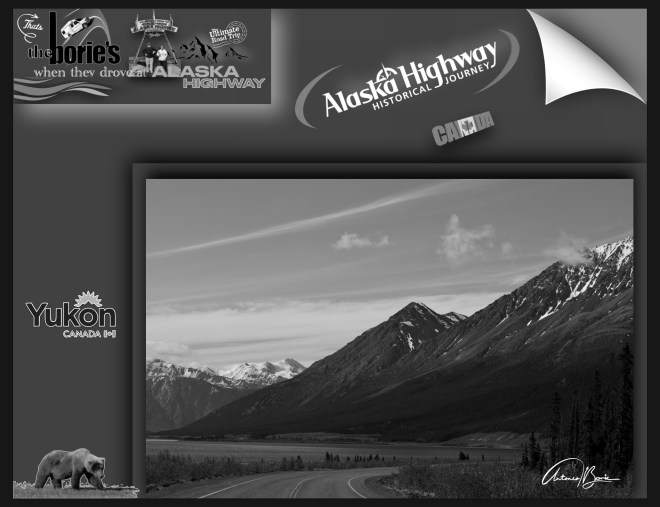
…a lendária e hoje “Histórica Alaska Highway”, entre outras coisas, é uma rota de aproximadamente 1.400 milhas, (2.400 quilómetros) que continua sendo a ligação vital entre as províncias de British Columbia e o Yukon no Canada, com o estado do Alaska, USA!.
…the legendary and today “Historic Alaska Highway”, among other things, is a route of approximately 1,400 miles, (2,400 kilometers) that remains the vital link between the provinces of British Columbia and the Yukon in Canada, with the state of Alaska, USA!.
…e nós já veteranos, viajando nela pela terceira vez, estávamos a ficar mais perto do Oceano Ártico e do “sol da meia-noite”!.
…and we, now veterans, traveling on it for the third time, were getting closer to the Arctic Ocean and the “midnight sun”!.
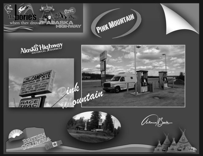
…como tal, a aventura começava num cenário, onde nos podia surgir uma extensa planície, uma montanha, um rio selvagem ou um longo trecho de uma estrada deserta, dentro de uma tempestade de chuva constante ou de neve branca e gelada, que possivelmente já nos afligia muito menos, porque já nos considerávamos veteranos ao viajar por esta lendária estrada, e sabíamos das dificuldades e de possíveis reparações, que são muito frequentes!.
…as such, the adventure began in a scenario, where we could see an extensive plain, a mountain, a wild river or a long stretch of a deserted road, within a storm of constant rain or white, icy snow, which possibly already distressed us much less, because we already considered ourselves veterans when traveling this legendary road, and we knew the difficulties and possible repairs, which are very common!.
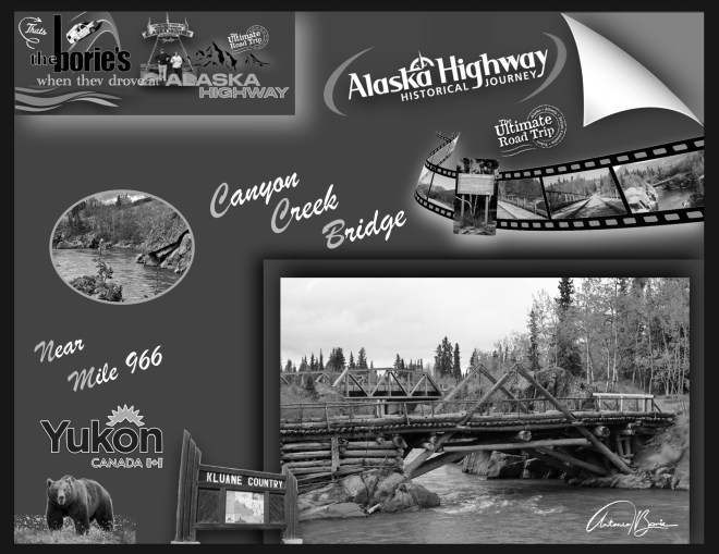
…esta histórica estrada, não só apoia as comunidades como serve de corredor para a vida selvagem, ligando as pessoas do Norte, milha a milha!.
…this historic road not only supports communities but serves as a wildlife corridor, connecting the people of the North, mile by mile!.
…foi construída através da natureza selvagem em apenas 8 meses, exigindo mais de 250.000 toneladas de materiais e o trabalho de 11.000 soldados, cerca de um terço dos quais eram soldados negros, membros de três regimentos segregados afro-americanos recém-formados, que viviam em campos remotos!.
…was built through wilderness in just 8 months, requiring more than 250,000 tons of materials and the labor of 11,000 soldiers, about a third of whom were black soldiers, members of three newly formed African-American segregated regiments, who lived in remote fields!
…houve a colaboração do Canadá, onde as “Primeiras Nações” da hoje províncias do Yukon e de British Columbia, compartilharam o seu conhecimento da terra, guiando o Corpo de Engenheiros do Exército dos EUA, através da mata, trilhas e armadilhas, tornando a rota possível!.
,,,there was collaboration from Canada, where the “First Nations” from today’s provinces of Yukon and British Columbia, shared their knowledge of the land, guiding the US Army Corps of Engineers, through the forest, trails and traps, making the route possible!.
…claro, ao mesmo tempo, toda esta construção ia perturbando o seu modo de vida, as suas terras, meios de subsistência e comunidades, deixando um impacto duradouro que ainda hoje é sentido!.
…of course, at the same time, all this construction was disrupting their way of life, their lands, livelihoods and communities, leaving a lasting impact that is still felt today!.
…ao longo dos anos, a hoje “Histórica Alaska Highway”, deixou de ser uma via acidentada e encharcada de chuva para se tornar um corredor de transporte totalmente pavimentado durante todo o ano, apoiando uma rota de transporte comercial, respondendo a emergências e milhares de viajantes que se dirigem para o norte todos os anos!.
…over the years, today’s “Historic Alaska Highway” has gone from a rugged, rain-soaked thoroughfare to a fully paved, year-round transportation corridor, supporting a commercial transportation route, responding to emergencies, and thousands of travelers heading north each year!
…foi construída no ano de 1942 e aberta ao tráfego civil no ano de 1948, sendo sempre renovada e modernizada consoante as frequentes derrocadas, alagamentos em pântanos e vegetação em decomposição!.
…it was built in 1942 and opened to civil traffic in 1948, always being renovated and modernized according to frequent landslides, flooding in swamps and decomposing vegetation!.
…onde vão sendo substituídas as iniciais pontes flutuantes, estacas em madeira ou piso térreo e lamacento por pontes em ferro e cimento e um pavimento em alcatrão permanentes com a sinalização possível!.
…where the initial floating bridges, wooden piles or ground and muddy floors are being replaced by iron and cement bridges and a permanent tar pavement with possible signage!.
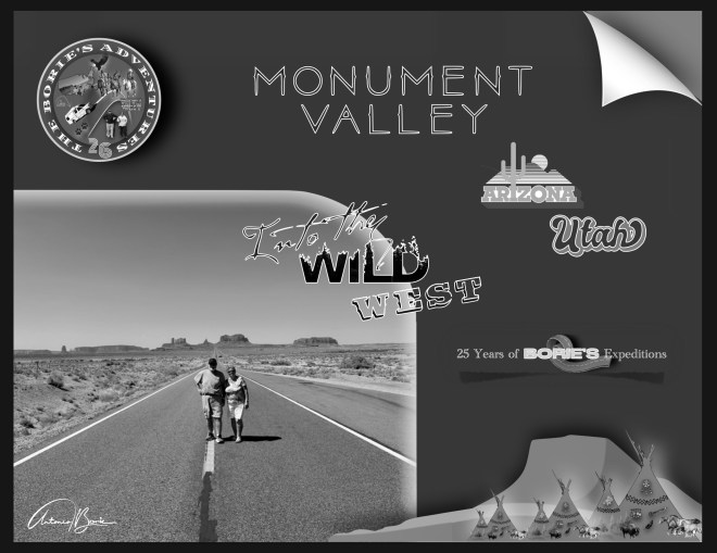
…viajávamos pela estrada US 163, aproximando-nos da fronteira entre os estados de Utah e Arizona, entrando num extenso vale onde o seu piso é em grande parte siltstone do Grupo Cutler, ou areia derivada dele, depositado pelos rios sinuosos que esculpiram este maravilhoso vale!. A sua cor vermelha viva, vem do óxido de ferro exposto no siltstone desgastado pelo tempo, onde também as suas rochas mais escuras e azul-acinzentadas, obtêm a sua cor do óxido de manganês!.
…we traveled on US 163 road, approaching the border between the states of Utah and Arizona, entering an extensive valley where its floor is largely siltstone of Cutler Group, or sand derived from it, deposited by the sinuous rivers that sculpted this wonderful valley!. Its bright red color comes from the exposed iron oxide in the weather-worn siltstone, where also its darker and blue-gray rocks get their color from manganese oxide!.
…é uma região que faz parte do Planalto do Colorado, que inclui grandes estruturas de pedra, incluindo o famoso “The Eye of the Sun” (o Olho do Sol), que é uma formação natural que assume a aparência de um olho, onde os sobreviventes da Nação Navajo têm encontros e festivais, com cantos e tambores!.
…is a region that forms part of the Colorado Plateau, which includes large stone structures, including the famous “The Eye of the Sun”, which is a natural formation that takes on the appearance of an eye , where the survivors of the Navajo Nation have encounters and festivals, with songs and drums!.
…apesar da elevação do fundo deste maravilhoso vale, poder variar entre 1.500 a 1.800 metros acima do nível do mar, a nossa “White Fox”, (caravana), deslizava suavemente!. O cenário era tal qual o dos filmes do Oeste, já avistávamos ao longe uma parte do vale, que logo nos fez lembrar a célebre frase do actor John Wayne, quando exclamava, “So this is where God put the west” (então é aqui que Deus colocou o oeste)!.
…despite the elevation of the bottom of this wonderful valley, to be able to vary between 1,500 and 1,800 meters above sea level, our “White Fox” (caravan),slid smoothly!. The scenery was just like that of the Western movies, we could already see in the distance a part of the valley, which immediately reminded us of the famous phrase of the actor John Wayne, when he exclaimed, “So this is where God put the west”!.
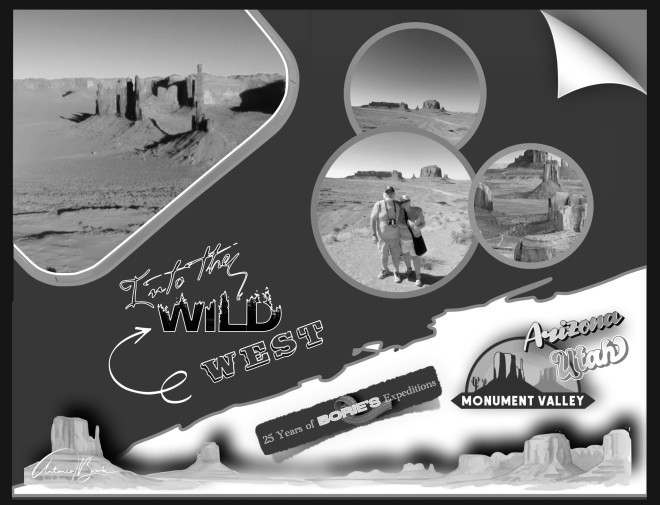
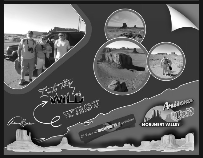
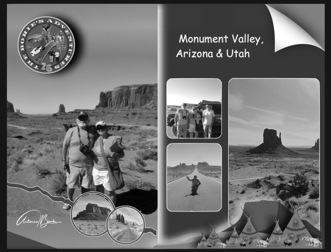
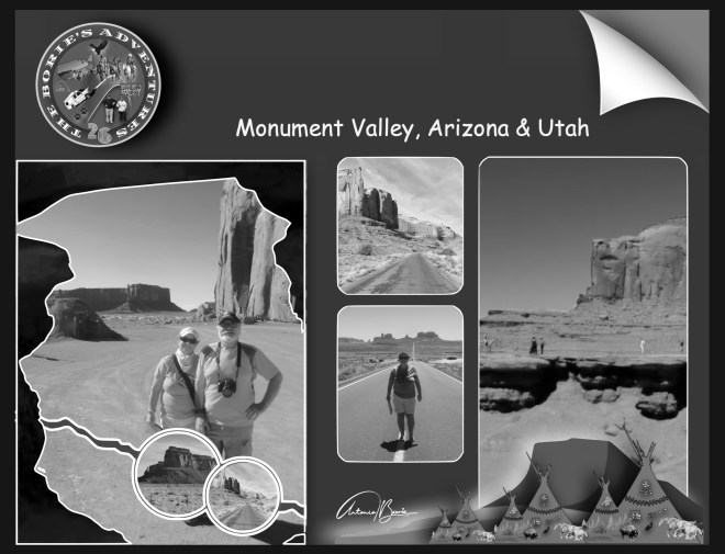
…o vale fica dentro do território da Reserva da Nação Navajo, a entrada era já ali, tivemos que pagar uma taxa de acesso, onde nos informaram que era possível viajar na nossa “White Fox”, (caravana), por uma certa área do parque numa estrada de terra com aproximadamente 27 quilómetros (uma viagem de duas a três horas), visitando algumas partes do Monument Valley!.
…the valley is within the territory of the Navajo Nation Reserve, the entrance was already there, we had to pay an access fee, where we were informed that it was possible to travel in our “White Fox” (caravan),, for a certain area of the park in a dirt road with approximately 27 kilometers (a trip of two to three hours), visiting some parts of Monument Valley).
…depois de percorrermos alguma área junto do Centro de Informação, onde tirámos algumas fotos ainda com sol, pois quando entrámos no parque, tentando fazer o “Loop Drive” (designação do circuito do parque), alguma chuva e mesmo trovoada, apareceu, no entanto seguimos e, o sol também regressou de novo, pelo menos em algumas áreas do percurso!.
…after crossing some area next to the Information Center, where we took some photos still with sun, because when we entered in the park, trying to do “Loop Drive” (designation of the circuit of the park), some rain and even thunderstorm, appeared, however we continued and, the sun also returned again, at least in some areas of the route!.
…conforme íamos avançando, o cenário era incrível!. Viajando pelo seu interior, o Monument Valley, a cada momento nos surgia pela frente uma paisagem natural, oculta entre pequenos monumentos de pedra vermelha que, entre outros viajantes que se aventuram nesta região selvagem!.
…as we were advancing, the scenery was incredible!. Traveling inland, the Monument Valley, every now and then a natural landscape, hidden among small red stone monuments that, among other travelers who venture in this wilderness!.
…ainda hoje, em alguns pontos estratégicos, podemos olhar o deserto onde sobressaiem altos monumentos e, depois de admirar o cenário, fechando os olhos por momentos, no pensamento, quase podemos ver uma diligência descendo a estrada de terra, pedra e areia!. Segundo relatos, mais de 400.000 pessoas visitam Monument Valley todos os anos!.
…even today, in some strategic points, we can look at the desert where high monuments stand out and, after admiring the scenery, closing our eyes for moments, in the thought, we can almost see a diligence descending the dirt road, stone and sand!. According to reports, more than 400,000 people visit Monument Valley every year!.
…nós, assim como a nossa “White Fox” (caravana), quando regressámos ao local do início do parque, estávamos cobertos de areia vermelha, depois de atravessar um cenário irregular, a princípio com alguma água e lama e, poeirento depois, mas contentes, não só pela paisagem, mas pelo que aprendemos sobre os índios da Nação Navajo!.
…we, like our “White Fox” (caravan),, returned to the site of the beginning of the park, we were covered with red sand, after crossing an irregular scenery, at first with some water and mud and then dusty, but glad not only by the landscape, but from what we learned about the natives of the Navajo Nation!.
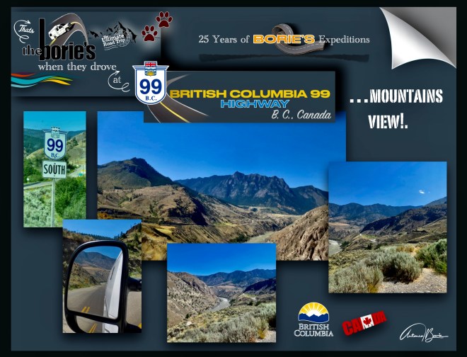
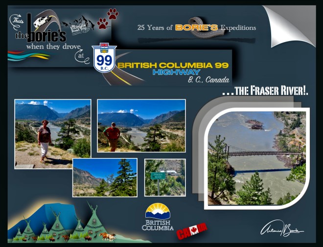
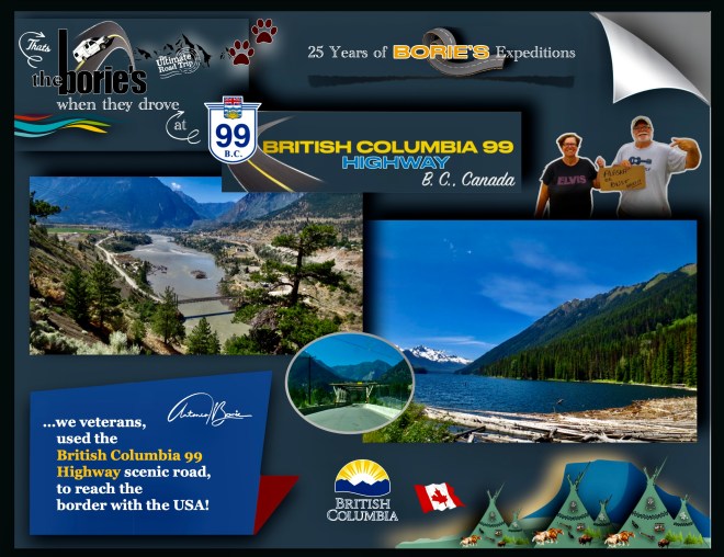
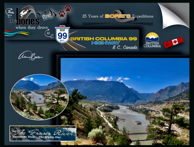
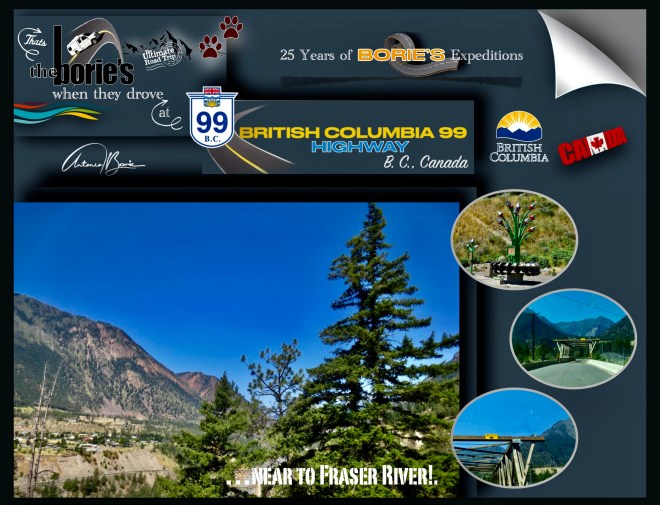
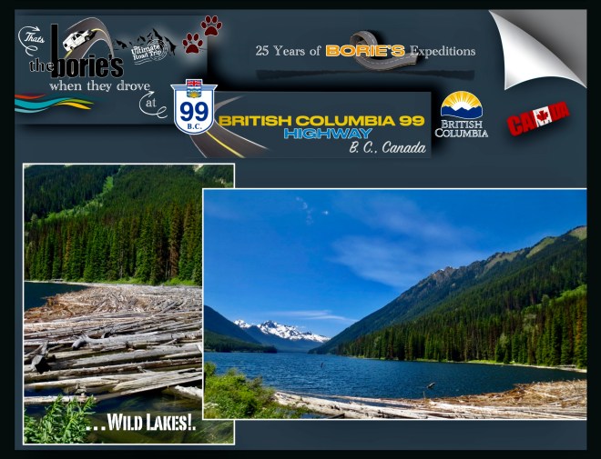
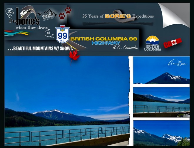
…a estrada 99 em B. C., Canadá, no ano de 2006, o jornal The Guardian, do Reino Unido, nomeou-a como a quinta melhor viagem pelo mundo!. Claro, passando lá próximo, esta notícia despertou-nos a atenção, porque nesta já um pouco avançada idade, com quase nada para perder, mantemos um lema, que para nós é apetecível, tal como, “Se isso é lindo mas te assusta, pode ser uma boa coisa para tentar”!.
…road 99 in BC, Canada, in 2006, the UK newspaper The Guardian named it as the fifth best road trip in the world!. Of course, passing by nearby, this news caught our attention, because at this slightly advanced age, with almost nothing to lose, we maintain a motto, which for us is appealing, such as, “If this is beautiful but scares you, it might be a good thing to try”!.
…como tal, aoouvir aquela simpática senhora, com sotaque de voz local, onde tínhamos parado para comprar gasolina, água e biscoitos, quando lhe perguntámos se íamos na direcção certa para poder entrar na estrada 99, pois era uma região onde o satélite não dava sinal ao nosso sistema de navegação, sorridente nos disse: Estrada 99?. É uma estrada quase deserta, que passa através das montanhas!. Se na verdade querem viajar por ela, fica mais ou menos a 1 hora ao sul, quantos quilómetros são, não sabemos!.
…as such, upon hearing that friendly lady, with a local accent, where we had stopped to buy gasoline, water and biscuits, when we asked her if we were going in the right direction to be able to enter road 99,as it was a region where the satellite did not give a signal to our navigation system, she smilingly told us: Road 99?.It is an almost deserted road, which passes through the mountains!. If you actually want to travel through it, it’s about 1 hour south, how many kilometers it is, we don’t know!
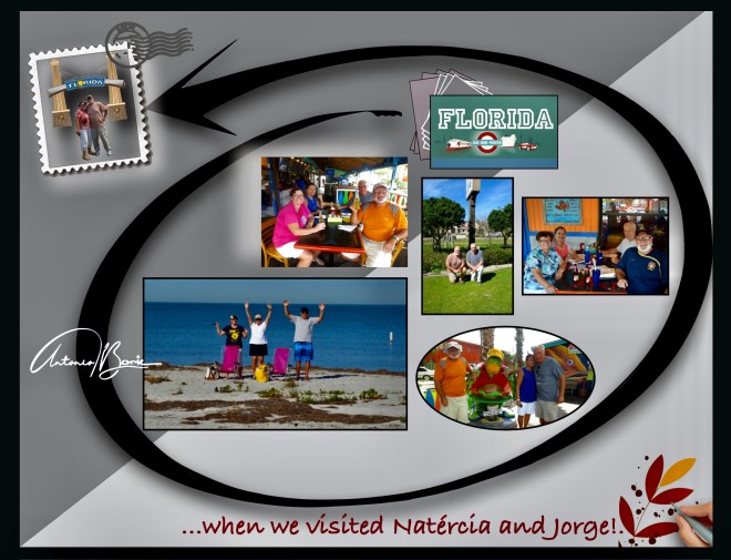
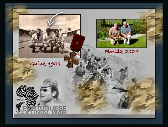
…quase considerados família, estão o casal Jorge e a Natércia, que criaram uma adorável e unida família, que por alguns períodos do ano vivem empoleirados no Golfo do México, mais propriamente na praia de Sandy Key, e que entre outras mordomias, frequentemente nos estendem convite para visitas de convívio, tornando-nos a nós, simples e comuns sobreviventes deste mundo, viver por alguns períodos de tempo com o rótulo de “cinco estrelas”!.
…almost considered family, are the couple Jorge and Natércia, who created a lovely and united family, who for some periods of the year live perched in the Gulf of Mexico, more precisely on the beach of Sandy Key, and who, among other perks, often extend an invitation to us for social visits, making it possible for us, simple and common survivors of this world, to live for some periods of time with the “five-star” label!.
…a Natércia é uma pessoa amável, compreensiva e inspiradora e…, nós e o Jorge, fomos “irmãos de guerra”, na maldita guerra colonial que o então regime de Portugal manteve em África nas suas antigas colónias e…, quis o destino que imigrássemos para este continente ainda antes da “revolução dos cravos”, por aqui vivendo, resistindo a todas as “mazelas” que aquela maldita guerra nos deixou, e não foram poucas, não só no corpo como na alma…, até esta bonita idade, que já vai passando os “oitenta”!
…Natércia is a kind, understanding and inspiring person and…, we and Jorge, were “brothers in arms”,in the cursed colonial war that the then Portuguese regime maintained in Africa in its former colonies and…, fate would have it that we immigrated to this continent even before the “carnation revolution”,living here, resisting all the“ills” that that damned war left us, and there were many, not only in the body but also in the soul…, until this beautiful age, which is already passing “eighty”!..
…e hoje, vamos contar num pequeno resumo, envolvendo-nos, do que foram os dias passados naquela maldita Guerra Colonial, onde o mais lamentável é que os famintos, os doentes, os analfabetos e a miséria que naquela época eram constantes, infelizmente continuaram, mesmo depois, quando parecia que já havia paz!. Cá vai!.
…and today, we are going to tell you in a small summary, involving ourselves, of what the days spent in that damned Colonial War were like, where the most regrettable thing is that the hungry, the sick, the illiterate and the misery that was constant at that time, unfortunately continued, even afterwards, when it seemed that there was already peace!. Here you go!.
…andava pó no ar, respira-se o ar quente e húmido que entrava nas narinas, fazendo-nos transpirar e molhar o camuflado!. Os militares de acção, andavam aflitos e na expectativa, era uma barafunda, davam-se dois passos e tropeçava-se em qualquer coisa!. O cheiro a gasóleo, dos motores das viaturas, que não paravam de trabalhar, sufocavam!. Havia outro cheiro esquisito, que devia de ser das fardas de camuflado e das armas de guerra que as tropas para-quedistas, que tinham acabado de ser lançados na área traziam!.
…there was dust in the air, we breathed in the hot, humid air that entered our nostrils, making us sweat and make our camouflage wet!. The soldiers in action were anxious and expectant, it was a mess, you took two steps and you tripped over something!. The smell of diesel, from the vehicles’ engines, which didn’t stop working, suffocated!. There was another strange smell, which must have come from the camouflage uniforms and weapons of war that the parachute troops, who had just been launched into the area, were carrying!.
…enfim, era um pandemónio nesse fim de tarde!. Nas tropas para-quedistas, estava o Jorge e pediu-nos água, talvez lembrando a água pura e cristalina, que bebia na encosta da montanha do Caramulo, de donde era oriundo em Portugal!.
…in short, it was pandemonium that late afternoon!. Jorge was among the paratrooper troops and he asked us for water, perhaps remembering the pure and crystal clear water he drank on the slopes of the Caramulo mountain, where he came from in Portugal!.
– Por favor, dá-me água, só água, mais nada!.
– Please give me water, just water, nothing else!
…os seus lábios estavam secos, os olhos fixos em qualquer coisa, que ninguém sabia o que era!. Naquele momento, não reconhecemos o amigo alegre e descontraído, que costumava ser, quando o visitávamos na capital da província, e claro, depois até recordámos uma dessas visitas, em que se juntou um grupo de amigos, e se bebeu o resto de um barril de vinho, roubado no aquartelamento e…, no final para não haver vestígios, queimou-se o barril!.
…his lips were dry, his eyes were fixed on something, no one knew what it was!. At that moment, we didn’t recognize the happy and relaxed friend he used to be when we visited him in the capital of the province, and of course, later we even remembered one of those visits, in which a group of friends got together, and a barrel of wine was drunk, stolen from the barracks and…, in the end so that there would be no trace, the barrel was burned!.
…continuando, aquela área de terra vermelha, dentro do nosso aquartelamento, era um pandemónio!. E nós, sendo um razoável militar, mas um fraco guerreiro, nunca nos sentindo confortáveis naquela zona de conflito e…, vendo tantos militares de acção, tantas armas e outro material bélico, calculem o nosso desespero!.
…continuing, that area of red earth, inside our barracks, was pandemonium!. And we, being a reasonable soldier, but a weak warrior, never feeling comfortable in that conflict zone and…, seeing so many soldiers in action, so many weapons and other war material, calculate our despair!.
…era alta madrugada, ainda noite do dia seguinte, começam a sair do aquartelamento quase todos ao mesmo tempo!. Era um comboio de viaturas, os helicópteros, faziam um ruído ensurdedor, levantando pó, folhas e lixo e…, o relato de acção (que não vamos descrever, para não lembrar momentos que ainda nos fazem estremecer de medo e angústia), que se seguiu, foi descrito por alguns intervenientes, principalmente pelo nosso amigo Jorge, e confirmado pelos relatórios que chegavam à nossa mão, porque fazia parte das nossas tarefas militares!.
…it was early in the morning, still in the evening of the next day, almost everyone started to leave the barracks at the same time! It was a convoy of vehicles, helicopters, making a deafening noise, raising dust, leaves and rubbish and…, the report of the action (which we will not describe, so as not to remember moments that still make us shudder with fear and anguish), which followed, was described by some participants, mainly by our friend Jorge, and confirmed by the reports that reached us, because it was part of our military tasks!.
…sim, num combate onde as foças inimigas, já com algum treino de guerra de guerrilha, equipadas com algumas armas modernas e conhecedores do terreno de acção, infelizmente causaram alguns mortos e feridos nas nossas forças!.
…yes, in a fight where enemy forces, already with some guerrilla warfare training, equipped with some modern weapons and knowledgeable about the terrain of action, unfortunately caused some deaths and injuries to our forces!.
…o Jorge, dado a sua coragem em cenário de combate, protegendo e ajudando os seus companheiros, onde recolheu da zona onde desesperadamente se combatia, transportando às suas costas um companheiro morto, que de outro modo, infelizmente por lá ficaria para sempre naqueles malditos pântanos do Golfo da Guiné!.
…Jorge, given his courage in a combat scenario, protecting and helping his companions, where he rescued from the area where there was desperate fighting, carrying a dead comrade on his back, who otherwise, unfortunately, would remain there forever in those damned swamps of the Gulf of Guinea!.
…pela sua bravura, foi condecorado com a medalha “cruz de guerra”, por altura do dia dez de Junho, no Terreiro do Paço, em Lisboa!.
…for his bravery, he was awarded the “war cross” medal, on the tenth of June, at Terreiro do Paço, in Lisbon!.
…Jorge e Natércia, por favor vão resistindo!. Neste momento, o hoje, é o mais importante, e oxalá que o amanhã venha com alguma saúde e paz!.
…Jorge and Natércia, please resist!. Right now,todayis the most important thing, and I hope that tomorrow comes with some health and peace!