…Sandy remembers!.

…Sandy remembers!.

…a Sandy lembra-se!.. (Sandy remembers)!.

…a nossa dedicada esposa Isaura, sofreu uma pequena intervenção cirúrgica!. Por uns dias ficou privada de certos movimentos mas, a nossa filha Sandy, com a boa compreenção do seu marido Brian, veio ajudar a sua mãe, aqui, no estado da Flórida!. (Our dedicated wife Isaura, underwent a minor surgical intervention!. For a few days she was deprived of certain movements, but our daughter Sandy, with the good understanding of her husband Brian, came to help her mother here in the state of Florida)!.

…Porquê?. A Sandy lembra-se, dos seus tempos de menina!. (Because?. Sandy remembers, from your girl times)!.

…de jovem!. (of young)!.

..de já mulher!. (Ready woman)!.

…pronta para enfrentar a sua vida!. (Ready to face your life)!.

…e constituir um lar!. (And constitute a home)!.

…onde a sua mãe Isaura, esteve sempre ao seu lado!. (Where your mother Isaura was always by your side)!.

…o seu lema continua a ser “Family is everything” (Família é tudo)!. (Your motto remains “Family is everything”)!.

…o seu dedicado marido Brian, ficou no estado de Nova Jersey, lá no norte, sózinho!. (Your devoted husband Brian, stayed in the state of New Jersey, up north, alone)!.

…cuidando de todo o labor da sua casa, lá no norte, tratando e cuidando os nossos netos ainda crianças, Brian e Ava!. (Taking care of all the work of your house, there in the north, treating and caring for our grandchildren still children, Brian and Ava)!.

…ela a Sandy, viajou para sul, trazendo consigo a nossa neta mais nova Leyla!. (She Sandy, traveled south, bringing our youngest daughter Leyla)!.

…que nos deliciou com as suas traquinices, tal como se tratasse de uma perfeita “terapia”, não só para nós, mas em especial para a sua avó Isaura!. (Which delighted us with its treachery, as if it were a perfect “therapy”, not only for us, but especially for his grandmother Isaura)!.

…é costume dizer-se que se aprecia melhor as atitudes, quando mais necessitamos delas e, a nossa filha Sandy, compreendeu, sacrificando a sua normal vida, vindo aqui ao sul ajudar a sua mãe nestes dias!. (It is customary to say that one appreciates better the attitudes, when we most need them, and our daughter Sandy, understood, sacrificing her normal life, coming here to the south to help her mother in these days)!.

…mãe, que tudo fez por ela, quando menina, jovem ou já mulher, para que enfrentasse o mundo, constituindo a sua própria família!. (Mother, who did everything for her, as a girl, young or old, to face the world, constituting her own family)!.

…família, é uma pequena palavra, mas que cria união e amor!. (Family, it’s a small word, but it creates unity and love)!.

…bem hajas, Sandy!. (Well, Sandy)!

Tony Borie, Novembro 2018.

…went to the City of Chrismas!.

…went to the City of Chrismas!.

…foram à Cidade do Natal!. (went to the City of Christmas)!.

…descendo as áreas ao longo do rio Delaware, a leste do estado da Pennsylvânia, um território histórico que alguns séculos atrás foi habitado por povos indígenas de várias culturas, que talvez sem o notarem, foram absorvidos pelo contacto com os primeiros colonos europeus, oriundos da área do meio do Atlântico, que eram holandeses, ingleses ou alemães! (Descending the areas along the Delaware River, east of the state of Pennsylvania, a historic territory that centuries ago was inhabited by indigenous people of various cultures, who perhaps without noticing it, were absorbed by contact with the first European settlers, from the middle area of the Atlantic, who were Dutch, English or German)!.

…claro, chegaram novas culturas!. Chegaram “Os Morávios” e, na véspera de Natal do ano de 1741, fundaram a comunidade missionária de Bethlehem (Belém) ao longo das margens do Monocacy Creek (Riacho Monocacy), junto ao Rio Lehigh, na colónia da Pennsylvânia, estabelecendo comunidades missionárias, entre os americanos nativos e os falantes de alemão sem igreja!. (Of course, new cultures arrived!. On the eve of Christmas in 1741, they founded the missionary community of Bethlehem along the banks of the Monocacy Creek near the Lehigh River in the colony of Pennsylvania, establishing missionary communities , among Native Americans and non-German speakers of German)!.

…em homenagem à cidade bíblica de Bethlehem (Belém da Judéia), que era o berço de Jesus, o seu chefe disse:

   – “Irmãos, quão mais apropriadamente poderíamos chamar nossa nova casa, do que nomeá-la em homenagem ao lugar onde o evento que agora comemoramos aconteceu!. Vamos chamar este lugar de Bethlehem (Belém)”!.

(In homage to the biblical city of Bethlehem of Judea, which was the cradle of Jesus, his chief said:

    – “Brethren, how much more appropriately could we call our new house than to name it in honor of the place where the event we now celebrate happened!. Let’s call this place Bethlehem”)!.

…assim, o nosso filho Tony, junto com a sua dedicada esposa Kathy, levaram os nossos netos Cody e Dawson, por esta mesma rota, seguindo ao leste do estado de Pennsylvania, pelo Vale de Lehigh, onde se celebram dezenas de festivais artísticos, comemorando o Natal, desde esse longínquo ano de 1741!. (So our son Tony, along with his devoted wife Kathy, took our grandchildren Cody and Dawson along the same route to the east of Pennsylvania through the Lehigh Valley where dozens of festivals artistic, celebrating Christmas, since that distant year of 1741)!.

…foram ver as celebrações de Natal na cidade Bethlehem (Belém), hoje, um dos mais charmosos destinos natalícios dos USA, onde se pode mergulhar na história do Natal, assistir a um show ou até participar numa aventura culinária!. Até lhe chamam, “The Christmas City” (Cidade do Natal)!. (Went to see Christmas celebrations in Bethlehem, today one of the most charming Christmas destinations in the USA, where you can immerse yourself in the history of Christmas, attend a show or even participate in a culinary adventure!. They even call it “The Christmas City”)!.

…andaram pela cidade, apreciaram os motivos de Natal, alguns com iluminação e música, estiveram no lado Sul do Distrito de Artes da cidade, mais propriamente no “campus artístico e cultural SteelStacks” (terrenos com edifícios artísticos e culturais chamados Pilhas de Aço), construído no local da antiga fábrica de Bethlehem Steel (Fábrica do Aço de Belém), que também chamavam Bethlehem Iron Company (Companhia de Ferro de Belém)!. (Walked around the city, appreciated the Christmas motifs, some with lighting and music, were on the South side of the city’s Arts District, more precisely on the “SteelStacks” artistic and cultural campus, built on the site of the former Bethlehem Steel factory, which they also called the Bethlehem Iron Company)!!

…andaram por lá, divertiram-se, lembrando e mostrando esta celebração cristã aos nossos netos!. O Tony e a Kathy, fotografaram a antiga fábrica do aço, que hoje dorme um sono pesado e longo, de onde nunca mais acordará, para contar a sua história, cujas raízes remontam ao ano de 1857!. Com minas de ferro em Cuba e estaleiros em todo o país, foi uma empresa siderúrgica, que chegou a ser a segunda maior produtora de aço dos Estados Unidos e a maior construtora naval!. (Walked there, amused themselves, remembering and showing this Christian celebration to our grandchildren!. Tony and Kathy photographed the old steel factory, which now sleeps a long, heavy sleep, from which it will never awaken, to tell its story, whose roots date back to 1857!. With iron mines in Cuba and shipyards all over the country, it was a steel company, which became the second largest steel producer in the United States and the largest shipbuilder)!.

…lembrando algumas das suas maiores odisseias, esta fábrica de aço, que agora dorme um sono eterno, já no longínquo ano de 1893, durante a Feira Mundial de Chicago, construiu uma estrutura projectada para tornar o mundo mais maravilhoso!. Foi o eixo gigante para a primeira roda-gigante do mundo, que precisou de aço suficiente para montar uma torre de 140 pés (43m), para apoiar uma roda inteiramente de aço, fazendo uma estrutura de 264 pés (80 m), cujo ferro foi feito nos seus altos fornos, sendo assim, a responsável pela maior peça única de ferro fundido do mundo, já fabricada até aquele momento!. (Remembering some of its greatest odysseys, this steel factory, which now sleeps an eternal sleep, already in the distant year of 1893, during the World’s Fair of Chicago, built a structure designed to make the world more wonderful!. It was the giant hub for the world’s first Ferris wheel, which needed enough steel to mount a 140-foot (43m) tower to support an all-steel wheel, making a 264-foot (80 m) was made in its blast furnaces, thus being responsible for the largest single piece of cast iron in the world, already manufactured until that time)!.


…durante a Primeira Guerra Mundial, a Segunda Guerra Mundial e nos anos seguintes, os 15 estaleiros da Bethlehem Shipbuilding Corporation (Empreza de Construção Naval), produziram um total de 1.121 navios, mais do que qualquer outro construtor durante a guerra e quase um quinto da frota de dois oceanos da Marinha dos EUA!. Empregou até 180.000 pessoas, a maior parte do emprego total da empresa, que era de 300.000 operários!. (During World War I, World War II and in the following years, the 15 shipyards of the Bethlehem Shipbuilding Corporation produced a total of 1,121 ships, more than any other builder during the war and almost a fifth of the US Navy’s two oceans fleet!. Employed up to 180,000 people, most of the company’s total employment, which was 300,000 workers)!.

…só durante a Segunda Guerra Mundial, 70% dos forjamentos de cilindros de aviões, um quarto da blindagem de navios de guerra e um terço dos canhões para as forças armadas dos EUA, foram aqui produzidos!. (Only during World War II, 70% of aircraft cylinder forgings, a quarter of the warship armor and a third of the guns for the US military were produced here)!.

…quando chegou o tempo de paz, a fábrica continuou a fornecer uma grande variedade de formas estruturais para os negócios de construção, contribuindo para inovações, participando no progresso, não só nos USA, como em muitas partes do mundo, fabricando o aço para muitos dos marcos mais proeminentes dos USA, como por exemplo, a Ponte George Washington, (Nova Yorque), Ponte Golden Gate (São Francisco), Ponte da Paz, (entre os USA e Canadá), ou a Ponte Verrazano-Narrows (Staten Island)!. (When peacetime arrived, the factory continued to provide a wide variety of structural forms for the construction business, contributing to innovations, participating in the progress not only in the USA, but also in many parts of the world, making steel to many of the most prominent landmarks in the USA, such as the George Washington Bridge, New York, Golden Gate Bridge, San Francisco, Peace Bridge, between the USA and Canada, or the Verrazano-Narrows Bridge, Staten Island)!.

…também fabricou o aço para a construção de alguns dos maiores edifícios, como por exemplo, Edifício da Ilha de Alcatraz, (São Francisco), Edifício Chrysler (Nova Iorque), Empire State Building (Nova Iorque), Madison Square Garden (Nova Iorque), Merchandise Mart (Chicago),
uma estrutura de aço de 53.000 toneladas na Chase Manhattan Plaza (Nova Iorque), Rockefeller Center (Nova Iorque) ou o Waldorf Astoria (Nova Iorque)!. (Also made steel for the construction of some of the largest buildings, such as Alcatraz Island Building, San Francisco, Chrysler Building, New York, Empire State Building, New York, Madison Square Garden, New York, Merchandise Mart, Chicago, a steel structure of 53,000 tons at the Chase Manhattan Plaza, New York, Rockefeller Center, New York or the Waldorf Astoria, New York)!.

…contribuíu com aço, que saiu dos seus fornos, para a construção da Barragem de Bonneville (Rio Columbia, Oregon), Grand Coulee Dam (Rio Columbia, Washington) ou a Barragem Hoover (Nevada/Arizona)!. (Contributed steel, which came out of its furnaces, for the construction of Bonneville Dam, Columbia River, Oregon, Grand Coulee Dam, Columbia River, Washington or Hoover Dam, Nevada / Arizona)!

…além de também fornecer o aço para os caminhos de ferro em diversos pontos do mundo, mencionando como por exemplo os carris dos eléctricos de São Francisco, a roda gigante “Wonder Wheel” em Coney Island (Nova Iorque), ou ainda fabricando o maior eixo gerador eléctrico do mundo, produzido para a General Electric na década de 1950!. (As well as supplying steel for the railways in different parts of the world, mentioning for example the rails of San Francisco trams, the Wonder Wheel in Coney Island (New York), or manufacturing the largest electric generator shaft in the world, produced for General Electric in the 1950s)!.

…a Fábrica do Aço de Bethlehem (Belém), foi dos mais poderosos símbolos da liderança da indústria industrial americana!. A sua morte é frequentemente citada como um dos exemplos mais proeminentes da economia americana se distanciando da manucfatura industrial, da sua incapacidade de competir com a mão-de-obra estrangeira barata e, da propensão da administração para lucros de curto prazo!. (The Steel Factory of Bethlehem, was one of the most powerful symbols of the leadership of the American industrial industry!. His death is often cited as one of the most prominent examples of the American economy distancing itself from industrial manufacturing, from its inability to compete with cheap foreign labor, and from management’s propensity for short-term profits)!.

…nós, quando novos e activos, fomos por um período de 30 anos, funcionários de uma empreza que se dedicava à fundição de metais, com responsabilidades na direcção do sindicato dos trabalhadores metallúrgicos dos USA, por tal, lembramos que, na década de 1970, o aço estrangeiro importado era geralmente mais barato do que o aço produzido internamente!. Claro, a empresa enfrentava a crescente concorrência de operações de menor escala que poderiam vender o aço a preços mais baixos!. (We, when new and active, went for a period of 30 years, employees of a company that was dedicated to the metal smelting, with responsibilities in the direction of the union of metallurgical workers of the USA, for such, we remember that, in the decade of 1970, imported foreign steel was generally cheaper than domestically produced steel!. Of course, the company faced growing competition from smaller-scale operations that could sell steel at lower prices)!

…assim, alguns anos depois, a Fábrica do Aço de Bethlehem (Belém), interrompeu a mineração de carvão e, fechou a produção de aço na principal fábrica de Bethlehem (Belém), após cerca de 140 anos de produção de metal!. Resultado, esta fábrica em Bethlehem (Belém), na Pennsylvânia, para tristeza de muitas famílias, encerrou as suas operações!. Importações de aço baratas e o fracasso da administração em inovar, abraçando novas tecnologias, melhorando as condições de trabalho contribuíram para o fim de Bethlehem (Belém)!. (So, a few years later, the Bethlehem Steel Plant interrupted coal mining and closed the steel production at the main Bethlehem plant in Bethlehem after some 140 years of metal production!. As a result, this factory in Bethlehem in Pennsylvania, to the sadness of many families, has ended its operations!. Cheap steel imports and management’s failure to innovate, embracing new technologies, improving working conditions have contributed to the end of Bethlehem)!.

…apesar de encerrar, numa acção de bom senso, tentou reduzir o impacto na região do Vale de Lehigh, com alguns planos para revitalizar o lado sul de Bethlehem (Belém). Contratou consultores para desenvolver planos conceituais sobre a reutilização da propriedade massiva. O consenso foi renomear o local de 163 acres (66 ha) da Fábrica de Bethlehem (Belém), e usar a terra para o desenvolvimento cultural, recreativo, educacional de entretenimento!. O Museu Nacional de História Industrial, em associação com a Smithsonian Institution e o Bethlehem Commerce Centre, consistindo de 1.600 acres (650 ha) de propriedade industrial principal, seriam erguidos no local, juntamente com um casino e um grande complexo de entretenimento!. (Despite closing in on common sense, tried to reduce the impact on the Lehigh Valley region, with some plans to revitalize the south side of Bethlehem!. Hired consultants to develop conceptual plans on the reuse of massive ownership!. The consensus was to rename the 163-acre site (66 ha) of the Bethlehem Factory, and use land for cultural, recreational, educational and entertainment development!. The National Museum of Industrial History, in association with the Smithsonian Institution and the Bethlehem Commerce Center, consisting of 1,600 acres (650 ha) of main industrial property, would be erected on site along with a casino and a large entertainment complex)!.

…hoje, o local da fábrica original, é o lar do SteelStacks (Pilhas de Aço), um distrito de artes e entretenimento!. Os cinco altos-fornos da usina ficaram de pé e servem de pano de fundo para o novo campus!. A SteelStacks atualmente conta com o ArtsQuest Center, um centro de artes performáticas contemporâneo, o Sands Casino Resort Bethlehem, um empório de apostas e novos estúdios para a estação WLVT-TV (canal 39) da PBS. A área também inclui três locais de música ao ar livre!. (Today, the original factory site, is home to SteelStacks, an arts and entertainment district!. The five blast furnaces of the plant stood and serve as a backdrop for the new campus!. SteelStacks currently has the ArtsQuest Center, a contemporary performing arts center, Sands Casino Resort Bethlehem, a betting emporium and new studios for PBS’s WLVT-TV station (channel 39). The area also includes three outdoor music venues)!.

…obrigado ao nosso filho Tony e sua dedicada esposa Kathy, pelos bons momentos que proporcionaram aos nosssos netos Cody e Dawson, que se deliciaram com este passeio ao lugar onde nesta época do ano, as celebrações cristãs, são evidenciadas como as mais representativas manifestações de Natal, em todo o território dos USA!. (Thanks to our son Tony and his devoted wife Kathy, for the good times they gave to our grandchildren Cody and Dawson, who enjoyed this walk to the place where at this time of year, Christian celebrations are evidenced as the most representative manifestations of Christmas, in all the territory of the USA)!.

…e, onde a narrativa tradicional do Natal, a Natividade de Jesus, delineada no Novo Testamento, diz que Jesus nasceu em Belém, de acordo com as profecias e, quando seus pais José e Maria chegaram à cidade, a estalagem não tinha espaço e ofereceram-lhes um estábulo em que o Menino Jesus nascera em breve, com os anjos proclamando esta notícia aos pastores que depois, também andaram por ali, espalhando a informação!. (And where the traditional Christmas narrative, the Nativity of Jesus, outlined in the New Testament, says that Jesus was born in Bethlehem according to the prophecies, and when his parents Joseph and Mary arrived in the city, the inn had not space and offered them a stable where the Baby Jesus was born shortly, with the angels proclaiming this news to the shepherds who later also walked around, spreading the information)!.

..embora hoje, os costumes comemorativos associados ao Natal têm uma mistura de temas e origens pré-cristãs, cristãs e seculares mas na verdade, nos costumes modernos existe uma troca de cartões de Natal, serviços da Igreja, uma refeição especial, bolachas de Natal, exibição de várias decorações de Natal, incluindo árvores de Natal, luzes de Natal, presépios, visco e azevinho, que envolvem uma atividade económica muito intensa, que tem crescido constantemente nos últimos séculos em muitas regiões do mundo!. (Even today, the commemorative customs associated with Christmas have a mixture of pre-Christian, Christian, and secular themes and origins, but in fact, in modern customs there is an exchange of Christmas cards, Church services, a special meal, Christmas, display of various Christmas decorations including Christmas trees, Christmas lights, cribs, mistletoe and holly, which involve a very intense economic activity, which has steadily grown in the last centuries in many regions of the world)!.

Tony Borie, November 2018.

…the sailors, who are “birds of the snow”!.

…os velejadores, que são “pássaros da neve”!. (The sailors, who are “birds of the snow”)!.

…nós andamos por ali quando o tempo o permite!. (We walk around when the weather allows)!.

…o nosso pensamento vai descobrindo novos oceanos, mas claro, com os pés bem assentes na areia, nunca perdendo a vista da costa!. (Our thinking is discovering new oceans, but of course, with our feet firmly in the sand, never losing sight of the coast)!.

…paramos aqui e ali, vemos alguns barcos ancorados, na baía do Rio Matanzas, parecem estar “invernando”, todavia alguns dos seus ocupantes, nadando ou em pequenos barcos insufáveis, vêm ao areal!. Nós, curiosos dizemos “olá”!. Eles, com desejos de conversa com pessoas de diferentes latitudes, fazem todo o tipo de perguntas, parece que querem “desabafar”!. (We stop here and there, we see some boats anchored in the bay of the Matanzas River, seem to be “wintering”, however some of their occupants, swimming or in small boats inflatable, come to the beach!. We, inquisitive say “hello”!. They, with desires of conversation with people from different latitudes, ask all kinds of questions, it seems they want to “vent”)!.

…esta baía, com história de corsários, rodeada de árvores, algumas com séculos de vida, que se falassem, nos contariam passagens de um mundo de outros tempos, talvez de batalhas navais, lutas territoriais mas, num cenário maravilhoso, cheio de beleza, charme e aventura!. (This bay, with a history of corsairs, surrounded by trees, some with centuries of life, that if they spoke, would tell us passages of a world of other times, perhaps of naval battles, territorial struggles but, in a wonderful scenario, full of beauty, charm and adventure)!.

…voltando a alguns dos ocupantes dos tais barcos ancorados nesta baía, que vêm ao areal, numa conversa lenta, fixando o seu olhar no infinito, quase não reparando em nós, acentuando o seu sotaque de voz do norte, dizem-nos mais ou menos:

…“Física e talvez mentalmente, estamos longe das nossas raízes, lá no norte, onde começámos a aventura de chegar na época de inverno, ao clima quente da Flórida!. O nosso barco navega lentamente, vamos conhecendo pessoas como vocês, ao longo da viajem, não temos a coragem de viajar no mar alto!. Não, não queremos navegar até às ilhas das Bahamas!.

…na costa leste, banhada pelo oceano Atlântico, por séculos, o tráfego de pequenos barcos, barcaças ou mesmo barcos de corsários vindos da Europa, moldaram o que hoje é conhecido como “Intracoastal Waterway”!. Funciona técnicamente como uma “estrada de água”, mais ou menos desde o estado de Massachusetts até a ponta do estado da Flórida!.

…portanto, navegamos protegidos de tempestades e ondas de água salgada, por alguns canais naturais ou artificias, que compreendem mais de 3.000 milhas (4.800km), sobre as águas, frias, mornas, limpas ou assim assim, por entre areia, lama, vegetação rasteira ou floresta, passando debaixo de pontes altas ou baixas, que começa lá no norte!.

…depois, alguns, cujos barcos são à vela, arrojam-se, fazendo diversas etapas do “lado de fora”, no oceano, o que não é o nosso caso, que navegámos desde a ponta de Nova Jersey, entre outras, aproveitando uma das áreas mais exploradas do “Intracoastal Waterway”, através da Virgínia e da Carolina do Norte que contorna o Cabo Hatteras!.

…aproveitamos as marés, para não encalhar o nosso barco, seguindo as bóias de sinalização, muitas vezes não prestando atenção a mais nada, incluindo os nossos mapas!. Os dias vão passando, saímos a terra aqui e ali, comprando géneros de primeira necessidade, somos capitães do nosso barco, vivendo em inteira independência!. Entre outras, temos o previlégio de ver o nascer e pôr do sol em diferentes cenários e, quanto mais avançamos para sul, o clima vai ficando mais quente, deixamos de ver a rota dos pássaros da neve, começando a ver pássaros tropicais”!.

…que conversa mais agradável, esta que tivémos com alguém que nunca tínhamos visto antes, lembrando-nos que, não há fim para as aventuras que podemos ter!.

(Returning to some of the occupants of such boats anchored in this bay, who come to the beach, in a slow conversation, fixing their gaze on infinity, hardly noticing us, accentuating their northern voice accent, tell us more or less:

“Physically and perhaps mentally, we are far from our roots, in the north, where we began the adventure of arriving in the winter season, in the warm climate of Florida!. Our boat sails slowly, we meet people like you, along the way, we do not have the courage to travel in the high sea!. No, we do not want to sail to the Bahamas!.

On the east coast, bathed by the Atlantic Ocean, for centuries, the traffic of small boats, barges or even corsair boats from Europe, have shaped what is now known as the “Intracoastal Waterway”!. It functions technically as a “waterway”, more or less from the state of Massachusetts to the tip of the state of Florida!.

Therefore, we sail protected from storms and waves of salt water, by some natural or artificial channels, that comprise more than 3,000 miles (4.800km), on the waters, cold, warm, clean or so, among sand, mud, undergrowth or forest, passing under high or low bridges, which starts there in the north!.

Then some, whose ships are sailing, throw themselves out, doing various steps from the “outside” in the ocean, which is not our case, which we sailed from the tip of New Jersey, among others, taking advantage of one of the most explored areas of the “Intracoastal Waterway” through Virginia and North Carolina that skirts Cape Hatteras!.

We take advantage of the tides, not to aground our boat, following the signal buoys, often not paying attention to anything else, including our maps!. The days go by, we leave the land here and there, buying necessities, we are captains of our boat, living in complete independence!. Among others, we have the privilege of seeing sunrises and sunsets in different scenarios, and the further we go south, the weather gets warmer, we do not see the route of snow birds, beginning to see tropical birds”!.

What a pleasant conversation we had with someone we had never seen before, reminding us that there is no end to the adventures we can have)!.

…hoje, caminhámos no “St. Joe Walkway”, que é uma das nossas habituais caminhadas, aqui na cidade onde vivemos!. (Today, we walked on the “St. Joe Walkway”, which is one of our usual walks, here in the city where we live)!.

…a maré estava cheia, havia tráfico no canal!. (The tide was full, there was traffic on the canal)!.

…eram os tais “pássaros da neve”, que preferem navegar no canal!. (It was the so-called “snowbirds”, who prefer to sail the canal)!.

…do que o fazer em mar aberto, por tal, entram na área da cidade de Santo Agostinho, mais própriamente, no St. Augustine Inlete, continuando, este canal, a que chamam “Intracoastal Waterway”, estende-se por aproximadamente 60 milhas!. (Than to do it in the open sea, as such, they enter the area of St Augustine, Augustine Inlete, continuing, this channel, which they call “Intracoastal Waterway”, extends for approximately 60 miles)!.

…em algumas zonas confunde-se com o Rio Matanzas ou o Rio Halifax e, é navegável, pelo menos até zona de Ponce de Leon Inlet, onde existe uma abertura natural, nas ilhas da barreira, no centro da Florida, que liga a extremidade norte da Lagoa Mosquito e a extremidade sul do Rio Halifax!. (In some zones is confused with the Matanzas River or the River Halifax and, it is navigable, at least until zone of Ponce of Leon Inlet, where there is a natural opening in the barrier islands in central Florida that connects the northern end of Mosquito Pond and the southern end of the Halifax River)!.

…que naquela zona, entra no Oceano Atlântico!. (Which in that area, enters the Atlantic Ocean)!.

…as garças, tanto azuis como brancas, procuravam algo para comer, têm uma visão excelente, talvez um anglo de 360 graus, pois assim que nos aproximamos, param nos movimentos, olham-nos de lado e levantam vôo!. (The herons, both blue and white, were looking for something to eat, they have an excellent view, maybe an Anglo of 360 degrees, because as soon as we approach, stop in the movements, look at us sideways and take flight)!.

…os Osprey estavam lá no seu lugar preferido, vendo o cenário à sua volta, em especial qualquer movimento na água do canal! (The Osprey were there in their favorite place, watching the scenery around them, especially any movement in the canal water)!.

…a nossa dedicada esposa Isaura, está a recuperar de uma pequena operação cirúrgica, como tal esteve quase todo o tempo sentada, vendo e fotografando estes maravilhosos barcos que nos fazem lembrar que, a vida é curta e o mundo é amplo e bonito, desfrute-o aproveite-o, se poder!. (Our dedicated wife Isaura is recovering from a minor surgical operation, as such she has been sitting almost all the time, watching and photographing these wonderful boats that remind us that life is short and the world is broad and beautiful, enjoy it enjoy it, if you can)!.

Tony Borie, November 2018.

…historic Alaska Highway!

…historic Alaska Highway!

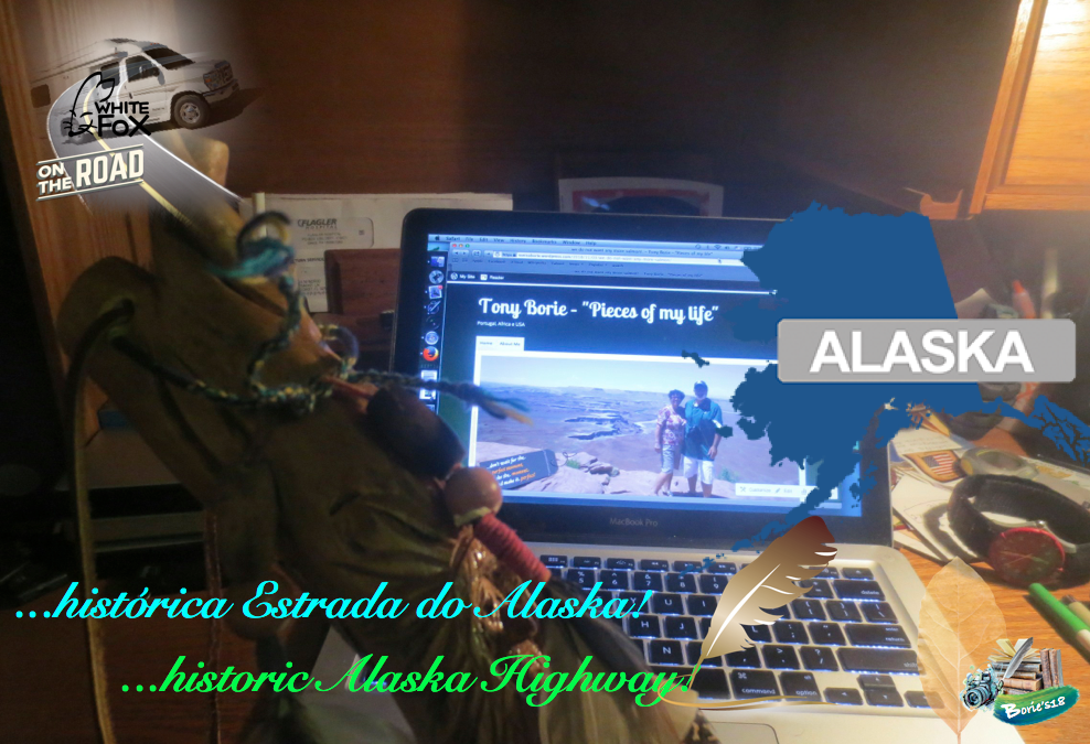
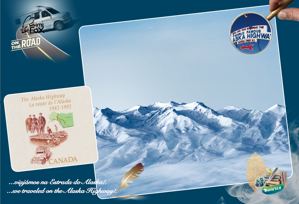
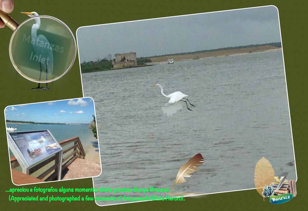
…histórica Estrada do Alaska!. (historic Alaska Highway)!.

…o mais belo do mundo é naturalmente o próprio mundo e, é bom andar perdido na direção certa, porque nem todos os que vagueiam por aí andam perdidos!. Se você está preparado, física e mentalmente, tem vontade em aprender, viaje o mais longe possível, dormindo no chão se for preciso, descobrindo outros lugares e outras pessoas que também vivem, comem e cozinham num qualquer lugar onde se emcontram!. Vá lá, aprenda com eles!. Voe, vagueie, viaje, talvez por lugares desertos, explore, descubra, aventure-se, porque um navio ancorado num porto, é verdade que está seguro, mas não foi para isso para que os navios foram construídos!. (The most beautiful in the world is naturally the world itself, and it is good to walk lost in the right direction, because not all who wander around are lost! If you are prepared, physically and mentally, you feel like learning, travel as far as possible, sleeping on the floor if you need to, discovering other places and other people who also live, eat and cook anywhere you meet! Come on, learn from them! Fly, wander, travel, perhaps through deserted places, explore, discover, venture out, because a ship anchored in a harbor, it is true that is safe, but it was not for that for which ships were built)!.

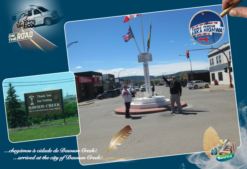
…tal como nós que, viajando por território do Canadá, pelo nordeste da província da Columbia Britânica, chegámos à cidade de Dawson Creek, uma típica cidade cujo nome deriva dum riacho que por aqui passa com o mesmo nome, que por sua vez o recebeu de um tal George Mercer Dawson, que era um membro de uma equipe de pesquisa de terras que, talvez tal como nós, também por aqui passou no ano de 1879!. (As we who, traveling across Canada, to the northeast of the province of British Columbia, arrived at the city of Dawson Creek, a typical city whose name derives from a stream that passes here with the same name, which in turn received him from a certain George Mercer Dawson, who was a member of a land search team, who perhaps just as we, also here passed in the year 1879)!.

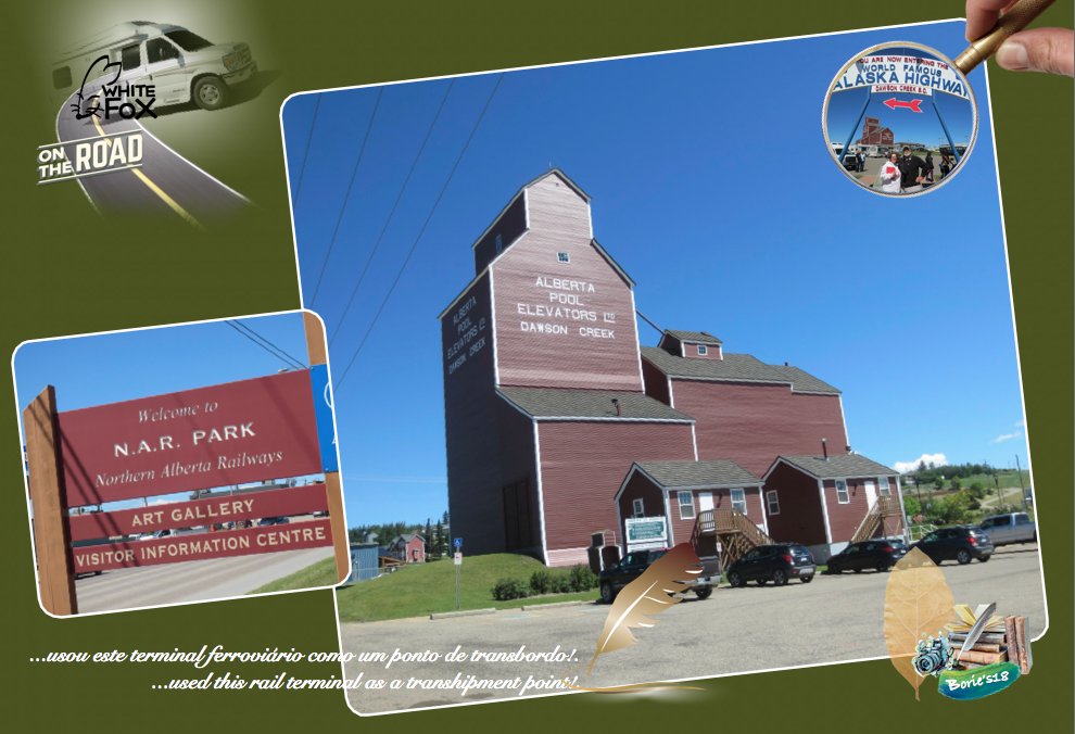
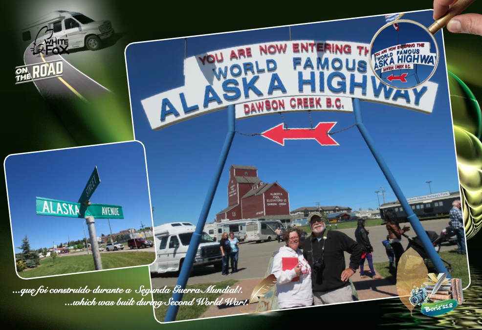
…explicando um pouco melhor, esta hoje cidade de Dawson Creek, de uma pequena comunidade agrícola, tornou-se num centro regional, após o terminal ocidental da “Northern Alberta Railways” (Caminhos de Ferro do Norte de Alberta), ser estendido até aqui, no ano de 1932, crescendo rápidamente quando por volta do ano de 1942, o Exército dos EUA usou este terminal ferroviário como um ponto de transbordo, durante a construção do hoje histórico, “Alaska Highway” (Estrada do Alaska)!. Passou então a ser chamada de “Capital of the Piece” (Capital da Paz), também conhecida como a “Mile 0 City” (Cidade da Milha 0), referindo-se à sua localização no extremo sul da Estrada do Alaska!. (Explaining a little better, this city today Dawson Creek, a small farming community, has become a regional center, after the western terminal of the Northern Alberta Railways, be extended up to here in the year 1932, growing rapidly when around 1942, the US Army used this rail terminal as a transhipment point during the construction of today’s historic, “Alaska Highway”!. It was then called the “Capital of the Piece”, also known as the “Mile 0 City”, referring to its location on the southern end of the “Alaska Highway”)!.

…sim, o “Alaska Highway”, a quem também chamam, “Alaskan Highway”, “Alaska Canadian Highway”, ou simplesmente “ALCAN Highway”, que traduzido para o idioma português, quer dizer mais ou menos Estrada do Alaska, que foi construído durante a “World War II”, (Segunda Guerra Mundial), com o propósito de haver uma via de comunicação terrestre entre o continente dos USA e o estado do Alaska, claro, passando pelo território do Canadá!. (Yes, the “Alaska Highway”, which they also call “Alaskan Highway”, “Alaska Canadian Highway”, or simply “ALCAN Highway”, which was built during World War II, with the purpose of having a terrestrial communication route between the continent of the USA and the state of Alaska, of course, passing through the territory of Canada)!.

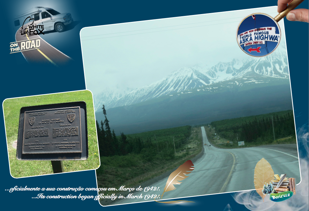
…a sua construção começou por volta do ano de 1942, pois o ataque do Japão à baía de Pearl Harbor, no Hawaii, começou um teatro de guerra no oceano Pacífico, com o Japão a querer avançar para ocupar a costa oeste dos USA, incluindo as “Aleutian Islands” (Ilhas Aleutian), que se situam também na parte oeste do Alaska!. Assim, em Fevereiro do ano de 1942, o Congresso dos USA, aprovou a sua construção e, o então presidente Franklin D. Roosevelt, mandou começar as obras uns dias depois!. O governo do Canadá concordou, com a condição de a construção ser financiada pelos USA e no final, a estrada e todas as facilidades dela proveniente, ficassem propriedade do governo do Canadá!. (Its construction began around 1942, as Japan’s attack on the bay of Pearl Harbor in Hawaii began a theater of war in the Pacific Ocean, with Japan wanting to advance to occupy the west coast of the USA, including the “Aleutian Islands”, which are also located in the western part of Alaska!. So, in February 1942, the US Congress approved its construction, and then President Franklin D. Roosevelt ordered the work to commence a few days later!. The government of Canada agreed, on the condition that the construction be financed by the USA, and in the end, the road and all facilities therefrom, be owned by the Government of Canada)!.

…oficialmente a sua construção começou em Março de 1942, depois de centenas de peças de equipamento de construção de estradas, terem sido transportadas com uma certa prioridade, por combóios da “Northern Alberta Railways” (Caminhos de Ferro do Norte de Alberta), com o pessoal do “U. S. Army Corps of Engineers”, (Corpo de Engenheiros do Exército dos USA), que é uma agência federal, que em conjunto com o “Major Army Command”, (Comando Maior do Exército), integrava alguns milhares de pessoas, tanto civis como militares, que ainda hoje estão associados à construção de barragens, canais ou até protecção contra inundações e outras catástrofes, não só nos USA, como em diversas partes do mundo!. (Its construction began officially in March 1942, after hundreds of pieces of road construction equipment were transported with a certain priority, by trains of the Northern Alberta Railways, with the staff of the U. S. Army Corps of Engineers, which is a federal agency that, along with the Major Army Command, comprised a few thousand people, both civilians such as the military, which are still associated with the construction of dams, canals or even protection against floods and other catastrophes, not only in the USA, but also in various parts of the world)!.

…trabalhando harduamente, em conjunto com os mesmos departamentos do governo do Canadá, pois havia notícias que o Japão queria invadir “Kiska Island” (Ilha de Kiska) e “Attu Island” (Ilha de Attu), na região das “Aleutians Islands” (Ilhas de Aleutians), e claro, tudo tinha que ficar completo antes que chegasse o inverno!. Em colaboração, uns começando pela parte do norte/oeste e outros pela parte do sul/leste, encontraram-se em Setembro do mesmo ano, no “Históric Milepost 588” (Histórica Milha 588), onde passava um riacho, que depois foi chamado de “Contact Creek” (Riacho do Contacto)!. (Working hard together with the same government departments of Canada as there were news that Japan wanted to invade “Kiska Island” and “Attu Island” in the region of “Aleutians Islands”, and of course, everything had to be complete before winter came!. In collaboration, some starting from the north / west and others from the south / east, met in September of the same year, at “Historico Milepost 588”, where a stream passed, which was later called of “Contact Creek”)!.

…foi construída com muito trabalho físico, onde era usada a pá, picareta e a vagoneta, por pessoas dedicadas, trabalhando muitas horas seguidas, nas mínimas condições de segurança, cumprindo um período de tempo para que se propuseram, pois em Outubro do mesmo ano, esta estrada estava completa!. (Was built with a lot of physical work, where the shovel, pickaxe and the wagon were used by dedicated people, working long hours in a safe way, fulfilling a period of time for which they proposed, since in October same year, this road was complete)!.

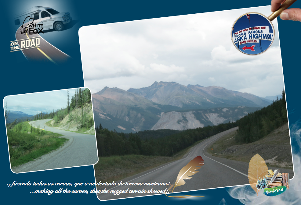
…mencionando algumas curiosidades, não existe em todo o seu percurso um único tunel, tudo foi feito à pressa, à luz do dia, sempre improvisando, com os recursos que naquela ocasião existiam, fazendo todas as curvas, que o acidentado do terreno mostrava!. Em algumas zonas, não sendo possível seguir, rasgavam o lado das montanhas, de onde tiravam terra, cascalho ou pedra, para colocar em alguns terrenos mais baixos, que eram alagadiços!. Outra curiosidade, foi que durante a sua construção foi chamada de “Oil Can Highway” (Estrada das latas de óleo), dado o grande número de latões vazios de óleo ou outro combustível, que iam ficando para trás, marcando o progresso da estrada!. (Mentioning some curiosities, there is not a single tunnel in all its course, everything was done in a hurry, in the light of day, always improvising, with the resources that at that time existed, making all the curves, that the rugged terrain showed!. In some areas, they could not follow, ripping the side of the mountains, from where they took land, gravel or stone, to put in some lower lands, which were flooded!. Another curiosity was that during its construction was called “Oil Can Highway”, given the large number of empty brasses of oil or other fuel, which were falling behind, marking the progress of the road)!.

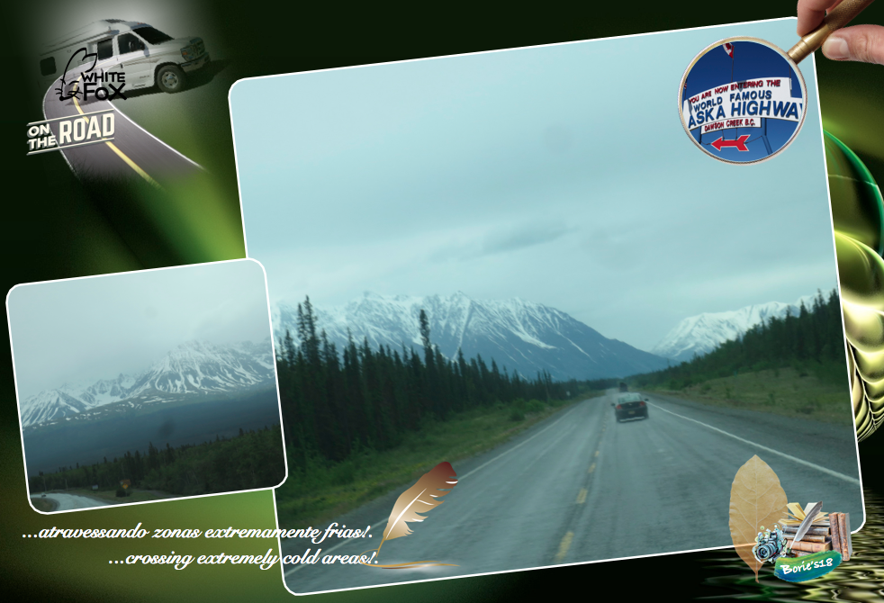
…esta estrada, construída em apenas oito meses, descrita como um dos maiores feitos de engenharia da história, através de um território completamente desconhecido, atravessando zonas extremamente frias, compostas por florestas, planícies, “glacieres” (neve acomulada em milhares, talvez milhões de anos), rochas, montanhas povoadas por animais e aves selvagens, lagos, rios revoltosos, alguns de água quente, lama, áreas infestadas de mosquitos, que juntou por terra o continente dos EUA ao estado do Alaska, permitindo que, principalmente os americanos, transportassem aviões até ao território da Rússia, no intuito de combater os alemães, por meio de uma cadeia de aeródromos e aeroportos remotos!. (This road, built in only eight months, described as one of the greatest engineering feats in history, through a completely unknown territory, crossing extremely cold areas, composed of forests, plains, “glacieres” (snow deployed in thousands, perhaps millions of years), rocks, mountains populated by animals and wild birds, lakes, riotous rivers, some hot water, mud, mosquito-infested areas, which overlanded the US mainland to the state of Alaska, the Americans, to transport airplanes to the territory of Russia, in order to fight the Germans, through a chain of aerodromes and remote airports)!.

…voltando à cidade de Dawson Creek, parámos no local onde se inicia este histórico, “Alaska Highway” (Estrada do Alaska), era ainda manhã, todavia já lá estavam algumas caravanas, motos e outros veículos, alguns vindo da Europa, onde despacham os seus veículos, via Frankfurt/Alifax, viajando depois de avião para este continente, pois muitas pessoas oriundas da Europa, principalmente alemães, italianos, ingleses ou franceses, alguns até oriundos da Austrália, prontos para percorrer as aproximadamente 1.500 milhas (2.400 km), que atravessam as províncias da Colúmbia Britânica e do Yukon, em território do Canadá, e parte do leste do estado do Alaska!. (Returning to the city of Dawson Creek, we stopped at the place where this historical begins, “Alaska Highway”, it was still morning, but there were already some caravans, motorcycles and other vehicles, some coming from Europe, where they dispatch their vehicles, via Frankfurt / Alifax, traveling by plane to this continent, since many people from Europe, mainly German, Italian, English or French, some even coming from Australia, ready to travel the approximately 1,500 miles (2,400 km), which cross the provinces of British Columbia and the Yukon, in the territory of Canada, and part of the eastern state of Alaska)!.

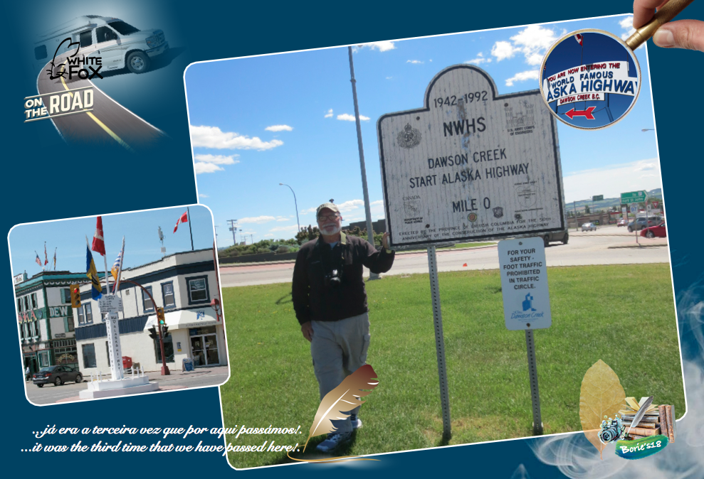
…andámos um pouco pela cidade, já era a terceira vez que por aqui passámos, pois em viajens anteriores, percorremos esta histórica estrada considerada por muitos como lendária ao longo de muitas décadas, principalmente por ser uma obra difícil e desafiadora para a época, todavia hoje a rodovia é quase toda pavimentada e estructurada, com sinais de tráfico, avisando para os precipícios, em quase todo o seu percurso mas, alguns desvios da estrada antiga ainda estão lá, sendo frequentemente usados pelos aventureiros!. Até já é popularmente (mas não oficialmente) considerada parte da estrada Pan-Americana, que se estende para o sul (apesar da sua descontinuidade no Panamá) até a Argentina!. (We walked a little through the city, it was the third time that we have passed here, because in previous trips, we have traveled this historic road considered by many to be legendary for many decades, mainly because it is a difficult and challenging work for the time, yet today the highway is almost all paved and structured, with signs of traffic, warning the cliffs, almost all of its route but, some deviations from the old road are still there, and are often used by the adventurers!. It is already popularly (but not officially) considered part of the Pan-American highway, which extends south (despite its discontinuity in Panama) to Argentina)!.

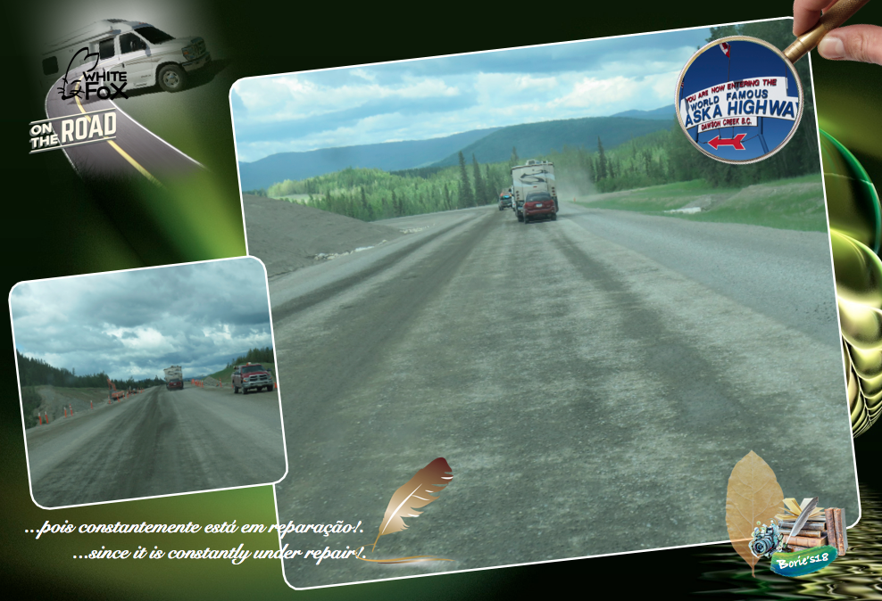
…a sua distância era maior nas ocasiões anteriores que por cá passámos, pois constantemente está em reparação, pelo menos na época de verão e, quando acontece uma avalanche por acumulação de neve nas montanhas, ou qualquer inundação junto dos diversos riachos e rios que ela atravessa, próprias do clima de inverno, na sua reconstrução, tentam sempre encurtar a sua distância, o que nos leva a crer que daqui a alguns anos já será uma estrada rápida, perdendo parte do seu encanto!. (Its distance was greater on previous occasions than we have been here since it is constantly under repair, at least in the summer season, and when there is an avalanche of snow accumulation in the mountains, or any flood along the various streams and rivers which it crosses, proper to the winter climate, in its reconstruction, always try to shorten its distance, which leads us to believe that in a few years will already be a fast road, losing some of its charm)!.

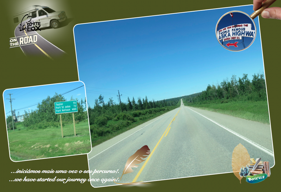
…iniciámos mais uma vez o seu percurso e, pelo menos, talvez nas suas primeiras 200 milhas (325 km), o progresso está a querer chegar, já existem povoações que são formadas única e simplesmente por trabalhadores de construção de estradas, com casas transportáveis, tipo “contentor”, onde existem já alguns hoteis, sempre com lotação esgotada, sem qualquer vaga, só para trabalhadores de construção, com oficinas e algumas plantas de cimento e alcatrão!. (We have started our journey once again, and at least maybe in its first 200 miles (325 km), progress is coming, there are already settlements that are formed only by road workers, with transportable houses, “container” type, where there are already some hotels, always sold out, without any vacancy, only for construction workers, with workshops and some cement and tar plants)!.

…todavia, lá para a frente, durante o seu percurso, ainda existem as tais pontes originais, que atravessam rios e ribeiros, precipícios, vistas de montanha, zonas de lagos, animais a atravessarem a estrada, não contentes com a presença humana no seu território!. (However, in the course of its journey, there are still such original bridges that cross rivers and streams, cliffs, mountain views, lake areas, animals crossing the road, not content with human presence on its territory)!.

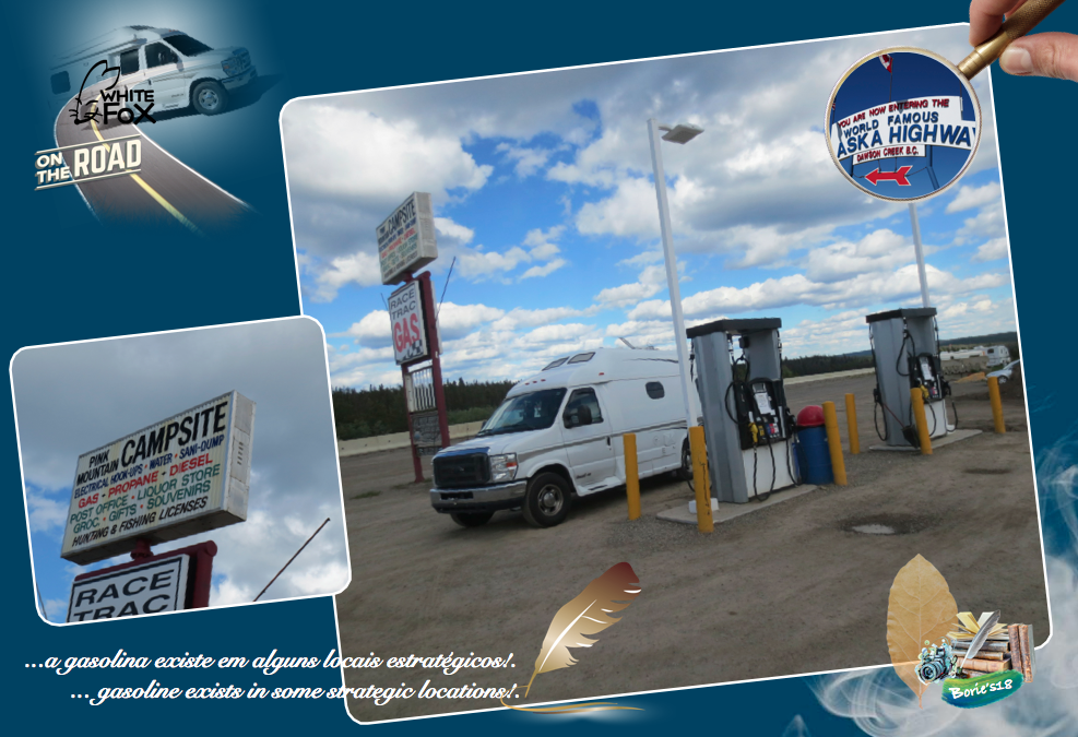
…é uma estrada especialmente para pessoas com gosto pela aventura, onde o GPS, tal como o telefone, em algumas zonas não recebe sinal de satélite, a gasolina existe em alguns locais estratégicos, com as suas aproximadamente 1.500 milhas (2.400 km), onde existe partes com muita terra, lama, pedra miúda ou graúda, algum alcatrão detiorado, riachos, buracos com água, alguns com dimensões para tomar banho, pontes em reparação, onde passa só um veículo de cada vez, entre outras coisas, a espera pelo “Carro Piloto”, que nos guia por uma determinada distância, onde não temos autorização de nos desviar da rota do referido carro!. (Is a road especially for people with a taste for adventure, where GPS, like the telephone, in some areas does not receive satellite signal, gasoline exists in some strategic locations, with its approximately 1,500 miles (2,400 km) , where there are parts with a lot of earth, mud, small or large stone, some tar tarred, streams, holes with water, some with dimensions for bathing, bridges in repair, where only one vehicle passes, among other things, the wait for the “Pilot Car”, which guides us for a certain distance, where we are not allowed to divert us from the route of said car)!.

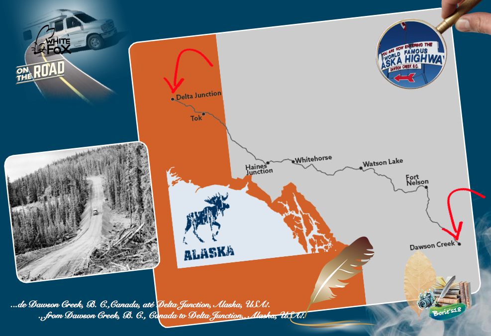
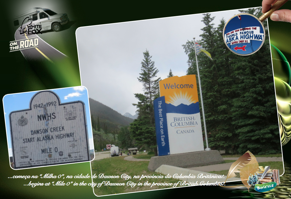
…hoje vamos explicar quais são, no nosso entender, as principais paragens deste corredor histórico, que tal como já escrevemos anteriormente, se estende por aproximadamente 1.500 milhas (2.400 km), abrangendo diversas comunidades, com aventuras ao ar livre, vistas para apreciar uma natureza intocada e uma vida selvagem indígena, que começa na “Milha 0”, na cidade de Dawson City, na província da Columbia Britânica e serpenteia pelo Yukon Territory, até à cidade de Delta Junction, já no estado do Alaska!. (Today we will explain what are, in our view, the main stops of this historic corridor, which, as we have already written, stretches for approximately 1,500 miles (2,400 km), covering various communities with outdoor adventures, enjoy pristine nature and indigenous wildlife that begins at “Mile 0” in the city of Dawson City in the province of British Columbia and meanders through the Yukon Territory to the city of Delta Junction, already in the state of Alaska)!.

…começamos na província da Columbia Britânica!. (We started in the province of British Columbia)!.

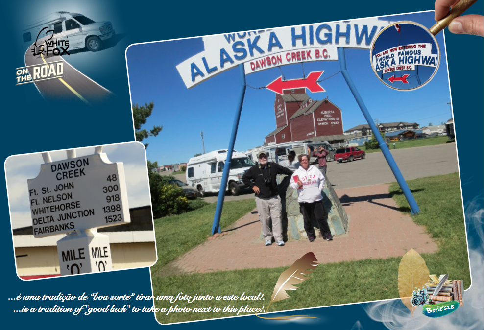
…Milha 0 – Cidade de Dawson Creek!. Já explicámos um pouco do que é a cidade, no entanto aqui existe um marco histórico assinalando o começo desta histórica estrada, onde dizem que é uma tradição de “boa sorte” tirar uma foto junto a este local, e claro, situado na mesma praça, podemos passar pelo Centro de Visitantes da cidade de Dawson Creek, que está localizado na antiga estação dos combóios, tomando conhecimento da história do famoso e histórico “Alaska Highway” (Estrada do Alaska), que vamos percorrer!. (Mile 0 – City of Dawson Creek!. We have already explained a little of what the city is, however here there is a historical landmark marking the beginning of this historic road, where it is said that it is a tradition of “good luck” to take a photo next to this place, and of course, situated in the same square, we can pass through the Dawson Creek Visitor Center, which is located in the old train station, taking in the history of the famous and historic “Alaska Highway”, which we are going to travel)!.

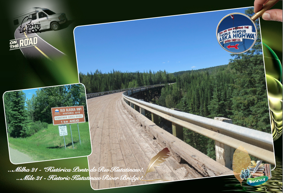
…Milha 21 – “Historic Kistatinaw River Bridge” (Ponte do Rio Kistatinaw)!.
Desviando-nos um pouco, viajando pela estrada original, encontramos a ponte sobre o rio Kiskatinaw!. Foi a primeira no seu tipo a ser construída no Canadá!. É uma ponte de madeira curva que começou a ser construída em 1942 e serviu como uma estrada militar pioneira, que ainda hoje nos leva ao Big Delta, lá no estado do Alaska!. Tem 534 pés (163m) de comprimento e, é uma paragem perfeita para esticar as pernas e mergulhar o olhar naquela floresta ondulada, admirando o rio caudaloso lá em baixo!. (Mile 21 – “Historic Kistatinaw River Bridge”!. Turning away a bit, traveling the original road, we find the bridge over the river Kiskatinaw!. It was the first of its kind to be built in Canada!. It is a curved wooden bridge that began to be built in 1942 and served as a pioneer military road, which still today takes us to the Big Delta, back in the state of Alaska!. It is 534 feet (163m) long and is a perfect stop to stretch your legs and look down at that wavy forest, admiring the mighty river below)!.

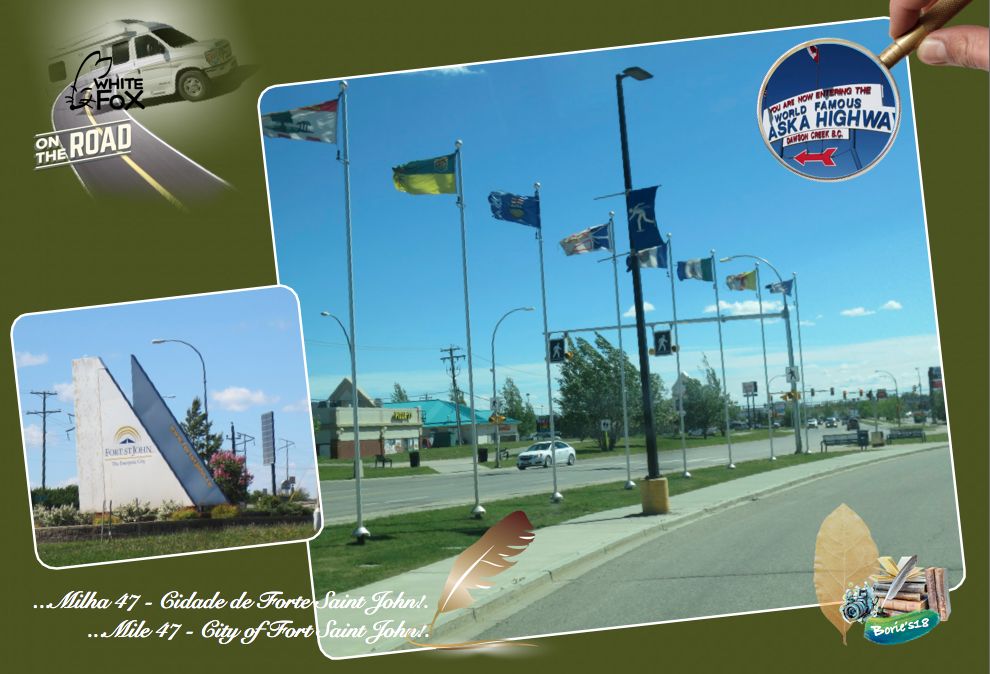
…Milha 47 – Cidade de Forte Saint John!. É uma grande comnidade, com restaurantes, lojas comerciais, Centro Comunitário, Centro de Visitas com internet e vária informação, estações de assistência mecânica e venda de gasolina, lojas para viajantes, alguns parques de lazer e aeroporto, entre outras atracções!. (Mile 47 – City of Forte Saint John!. It is a great community, with restaurants, shopping stores, Community Center, Visitor Center with internet and various information, stations of mechanical assistance and sale of gasoline, shops for travelers, some leisure parks and airport, among other attractions)!.

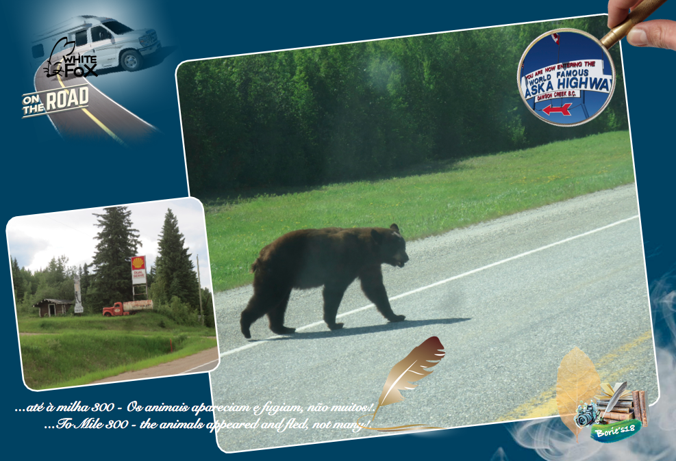
…até à milha 300 – Antes de atravessar a região do Rio da Paz, vão surgindo algumas povoações, que são um autêntico “oasis”, tendo lá o necessário para sobreviver, outras estão única e simplesmente abandonadas, com casas desertas, árvores e ramagem nascida dentro das casas, mas não deixavam de ter o o seu encanto!. Alguma construção, pois a estrada estava muito melhor do que há alguns anos, quando viajámos por aqui, os animais apareciam e fugiam, não muitos!. (To Mile 300 – Before crossing the region of the Piece River, some settlements appear, which are an authentic “oasis”, having there what is necessary to survive, others are single and simply abandoned, with deserted houses, trees and a branch born within the houses, but they did not fail to have the charm!. Some construction, because the road was much better than a few years ago, when we traveled here, the animals appeared and fled, not many)!.

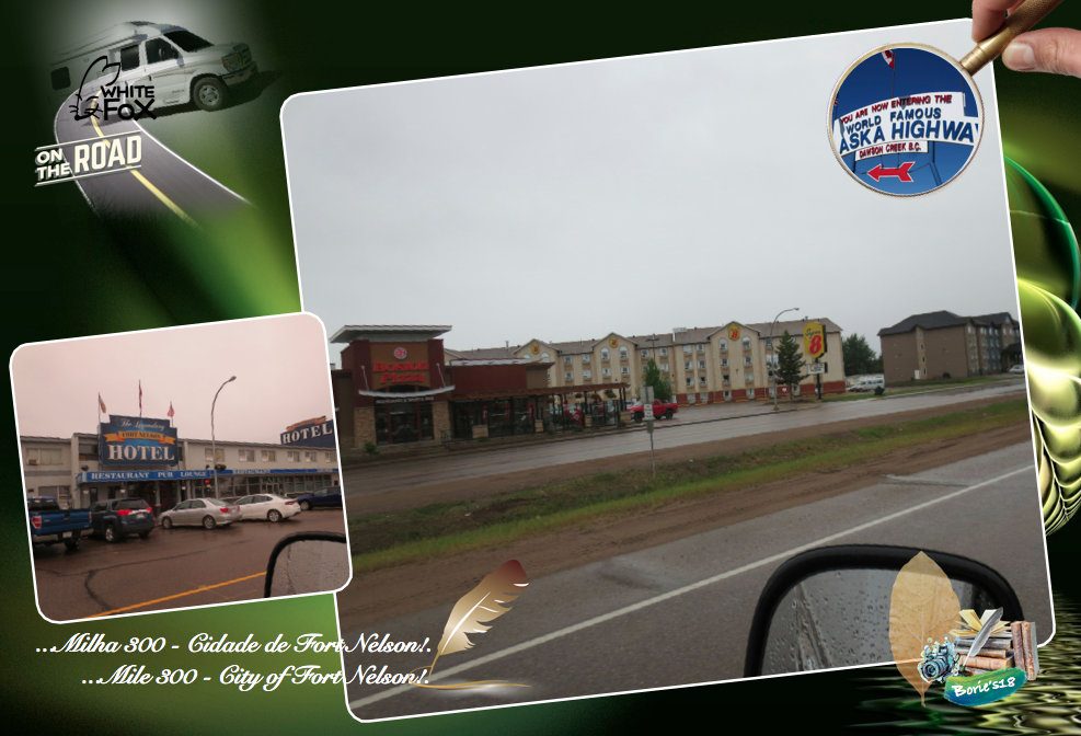
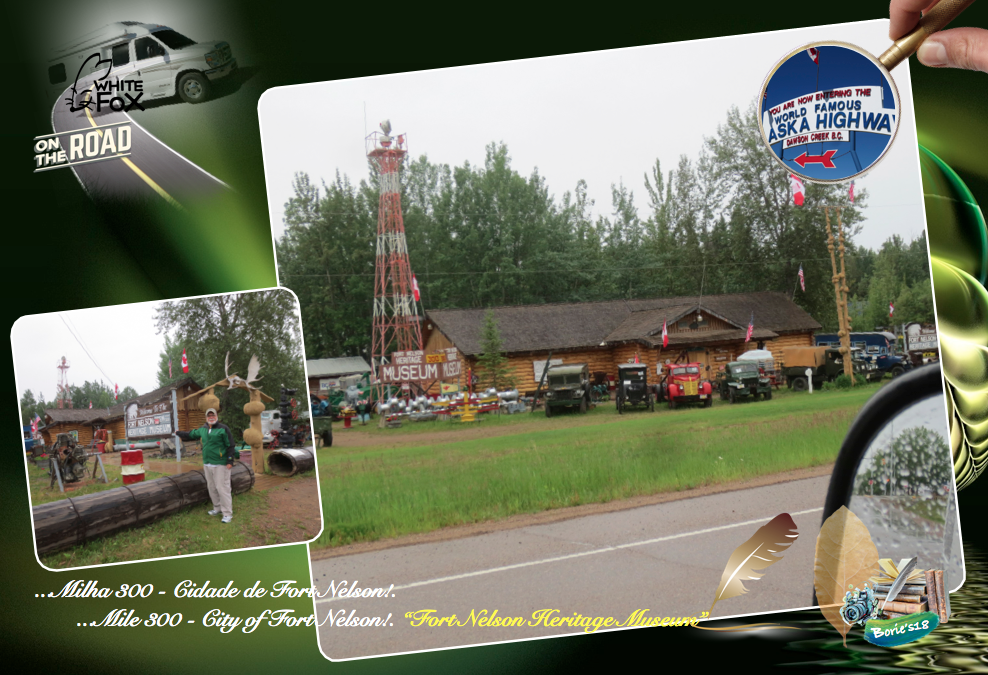
…Milha 300 – Cidade de Fort Nelson!. Históricamente concentrada nas indústrias de energia e turismo, cercada de parte da floresta boreal do Canadá. Está situada na margem sudoeste do campo de petróleo e gás da Grande Serra. Tem história, com o seu aeroporto a ser um bem valioso para as forças militares aliadas na Segunda Guerra Mundial, pois serviu como base aérea para a Força Aérea dos Estados Unidos e para a Royal Air Force!. (Mile 300 – City of Fort Nelson!. Historically concentrated in the energy and tourism industries, surrounded by part of Canada’s boreal forest!. It is situated on the southwest bank of the Great Serra oil and gas field!. It has history with its airport being a valuable asset to allied military forces in World War II as it served as the air base for the United States Air Force and the Royal Air Force)!.

…após aproximadamente os oito ou nove longos e árduos meses, que durou a construção da famosa e histórica Estrada do Alaska, atraiu mais de 11 mil trabalhadores para esta área, fazendo da cidade de Fort Nelson um centro de serviço movimentado, onde hoje existem hoteis, restaurantes, estações de serviço, lojas comerciais e outras atracções que normalmente encontramos em outras pequenas cidades do interior, com destaque para o “Fort Nelson Heritage Museum”, que começou com uma coleção de carros antigos, dedicada ao tema de transporte mas que hoje apresenta ferramentas manuais antigas, amostras de minerais e monumentos dedicados aos homens e mulheres que ajudaram a dar vida à famosa Estrada do Alaska!. (After approximately eight or nine long and arduous months, spanning the construction of the famous and historic Alaska Highway, attracted more than 11,000 workers to this area, making the city of Fort Nelson a busy service hub where today there are hotels, restaurants, petrol stations, commercial stores and other attractions that we normally find in other small towns in the hinterland, especially the “Fort Nelson Heritage Museum”, which began with a collection of antique cars, dedicated to the theme of transportation which today features antique hand tools, mineral samples and monuments dedicated to the men and women who helped bring the famous Alaska Road to life)!.

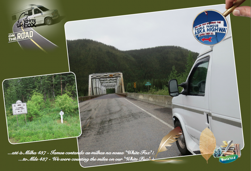
…até à Milha 437 – Íamos contando as milhas na nossa “White Fox”, (nome da nossa caravana), portanto talvez não sejam muito certas as contagens, porque parávamos, desviando-nos para cenários de rios, ribeiros ou pequenas montanhas com neve, cascatas de água pura, ou parando para dar passagem a alguns ursos pretos ou castanhos, lobos, raposas, alces, búfalos, aves e outros animais a atravessarem a estrada, ou a fugirem, escondendo-se no interior das florestas que circundam a estrada, e claro, com as reparações que constantemente fazem, encurtam a estrada, desviando-se de partes que anteriormente eram mais perigosas e constantemente estavam com água e lama, portanto já são menos milhas do que aquelas que os marcos de contagem nos dizem!. (To Mile 437 – We were counting the miles on our “White Fox” (name of our caravan), so maybe the counts are not very accurate, because we stopped, diverting us to scenarios of rivers, streams or small mountains with snow, cascades of pure water, or stopping to give passage to some black or brown bears, wolves, foxes, elk, buffalo, birds and other animals crossing the road, or fleeing, hiding within the surrounding forests the road, and of course, with the repairs they constantly make, shorten the road, turning away from parts that were once more dangerous and were constantly with water and mud, so they are already less miles than the landmarks tell us)!.

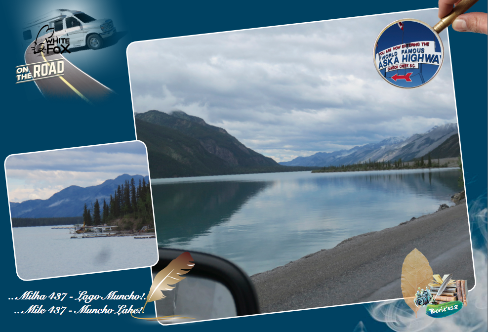
…Milha 437 – “Muncho Lake” (Lago Muncho)!. Viajando pela Estrada do Alaska, começamos a ver uma cordilheira de montanhas sem qualquer vegetação, a estrada vai encostada a algumas rochas, começa a descer e prossegue junto à água cor de jade, por uma extensão de aproximadamente 7 milhas (12 km), já sabemos que chegámos ao “Muncho Lake” (Lago Muncho), um refúgio perfeito para fazer uma caminhada cénica à beira do lago, com água também pura, vinda dos “glacieres” (neve acomulada em milhares, talvez milhões de anos), que se pode beber, onde existe entre outras coisas, uma boa opção para acampar no “Strawberry Campground”, onde já pernoitámos duas vezes em viajens anteriores e que, pela manhã quando abrimos a porta da caravana, deparamos com um cenário de montanha e lagos que talvez custasse “um milhão de dollares”, onde alguns animais, vêm beber água àquela parte do lago, mas que não era possível ver, se não nos tivéssemos “arrojado” a esta aventura!. (Mile 437 – “Muncho Lake”!. Traveling along the Alaska Highway, we begin to see a mountain range without any vegetation, the road is leaning against some rocks, begins to descend and continues along the jade water, for an extension of approximately 7 miles (12 km), already we know that we have arrived at “Muncho Lake”, a perfect getaway for a scenic lakeside hike with pure water, coming from “glacieres” (thousands of years of snow), you can drink, where there is among other things, a good option to camp in the “Strawberry Campground”, where we have stayed overnight in previous trips and in the morning when we opened the caravan door, we came across a mountain scenery and lakes that maybe it cost “a million dollars”, where some animals come drinking water to that part of the lake, but that could not be seen, if we had not “thrown” to this adventure)!.

…até à Milha 476 – Abandonando a região do “Muncho Lake” (Lago Muncho), vamos apreciando um cenário rodeado por picos de montanha, alguns cobertos de gelo, com milhões de anos, com uma altura que chega a atingir os 6,560 pés (2.000m), mas não podemos esquecer que o lago se situa mais ou menos a 2,850 pés (800m), do nível da água do mar, cuja água é proveniente do Trout River (Rio das Trutas), e dos “glacieres”, que agora explicando melhor, são uma grande e espessa massa de gelo formada em camadas sucessivas de neve compactada e recristalizada, de várias épocas, em regiões onde a acumulação de neve é superior ao degelo e, para quem não sabe, o gelo dos “glacieres”, é o maior reservatório de água doce, que existe sobre a terra!. A cor da sua água verde jade, dizem que é atribuida à presença oxido de cobre, nas rochas que compõem a base do seu leito e, o seu nome deriva da lingua “Kaska”, que designa “muncho” que quer dizer “muita água”!. (To Mile 476 – Leaving the Muncho Lake region, we will enjoy a scenario surrounded by mountain peaks, some covered with ice, with millions of years, with a height that reaches 6,560 ft (2,000 m), but we can not forget that the lake is more or less at 2,850 ft (800 m) from the level of sea water, whose water comes from the Trout River and the “glaciers”, which now explaining better, are a large and thick mass of ice formed in successive layers of compacted and recrystallized snow of various times in regions where snow accumulation is superior to the melting ice, and for those who do not know, glacieres, is the largest reservoir of fresh water, which exists on land!. The color of its jade green water is said to be attributed to the presence of copper oxide in the rocks that make up the base of its bed, and its name derives from the Kaska language, which designates “muncho” meaning “a lot of water”)!

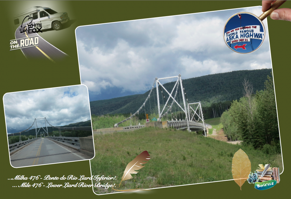
…Milha 476 – “Lower Liard River Bridge” (Ponte do Rio Liard Inferior), que é a única ponte suspensa nesta histórica Estrada do Alasca!. Esta ponte suspensa de 1.143 pés (350m), foi construída pela American Bridge Co. e McNamara Construction Co. de Toronto, em 1943, sobre o Rio Liard, que flui para o leste em direcção ao Rio Forte Nelson e, é paralelo com a Estrada do Alaska, onde passa a Ponte do Rio Liard Inferior, para a fronteira das províncias da Columbia Britânica com a do Yukon!. O Grand Canyon panorâmico do Liard River, é para o leste, e não é visível da estrada, onde muitos dos primeiros comerciantes de peles, perderam a vida negociando nas águas selvagens do Rio Liard!. (Mile 476 – “Lower Liard River Bridge” which is the only suspension bridge on this historic Alaskan Highway!. This 1,143-foot (350m) suspension bridge was built by the American Bridge Co. and McNamara Construction Co. of Toronto in 1943 on the Liard River, which flows eastward into the Nelson Fort River and parallels the Alaska Highway, where it passes the Lower Liard River Bridge, to the border of the provinces of British Columbia with the Yukon!. The scenic Grand Canyon of the Liard River is to the east, and is not visible from the road, where many of the early fur traders lost their lives trading in the wild waters of the Liard River)!.

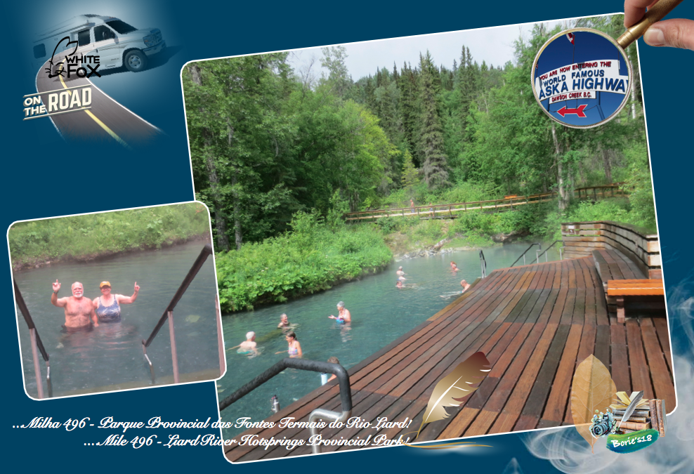
…Milha 496 – “Liard River Hotsprings Provincial Park” (Parque Provincial das Fontes Termais do Rio Liard)!. É quase paragem obrigatória, por tal parámos e fomos tomar banho numa repreza de água quente e natural, que é o lar das segundas maiores fontes termais no Canadá!. O primeiro corredor em madeira, assim como as instalações para as piscinas, foram construídos pelo exército dos Estados Unidos em 1942!. Originalmente chamavam-lhe “Theresa Hot Springs” (Fontes Termais da Tereza), que também contém um pântano de água quente e uma floresta boreal que apoia a comunidade de plantas ricas e diversas, bem como espécies de mamíferos e aves!. Em alguns momentos, podemos observar os alces, alimentando-se nos pântanos de água morna!. Os ursos, também são um perigo comum nos meses de verão e, podem estar comendo apenas a 10 pés (3m) de distância dos banhistas!. Devido à vida vegetal exuberante, influenciada pelo calor das águas, a área foi originalmente conhecida como “Vale Tropical”!. (Mile 496 – “Liard River Hotsprings Provincial Park”!. It is almost obligatory stop, so we stopped and went to bathe in a dam of hot and natural water, which is home to the second largest hot springs in Canada!. The first wooden hallway, as well as the facilities for the pools, were built by the United States Army in 1942!. They originally called it “Theresa Hot Springs,” which also contains a hot water swamp and a boreal forest that supports the community of rich and diverse plants as well as species of mammals and birds!. At times, we can observe the moose, feeding on marshes of warm water!. Bears are also a common hazard in the summer months and may be eating only 10 feet (3m) away from the bathers!. Due to the exuberant plant life, influenced by the heat of the waters, the area was originally known as “Tropical Valley”)!.

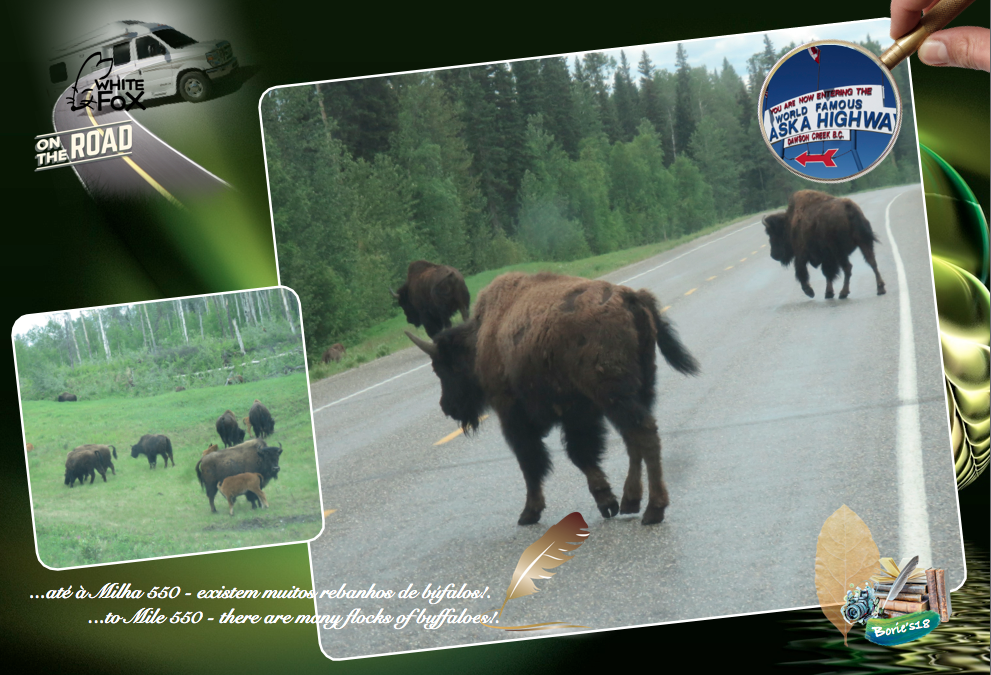
…até à Milha 550 – Ao longo da estrada, existem letreiros avisando que pelo menos uma área junto à estrada, que se estende por mais de 60 milhas, existem muitos rebanhos de búfalos, compostos por machos, fêmeas, bezerros e sub adultos. Os búfalos velhos, são solitários ou formam pequenos grupos!. (To Mile 550 – Along the road, there are signs that at least one area along the road, which extends for more than 60 miles, there are many flocks of buffaloes, composed of males, females, calves and sub adults!. Old buffalo, are solitary or form small groups)!.

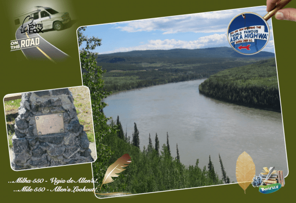
…Milha 550 – “Allen’s Lookout” (Vigia de Allen’s), que é um lugar onde existe uma Área de estacionamento em cascalho, muito grande, virada para o oeste, com mesas de piquenique, um bom lugar para fazer uma fogueira e cozinhar, tendo caixas em ferro, para colocar o lixo, com um lindo ponto de vista do Rio Liard, com uma bonita vista do rio. A lenda diz, que um bando de foras da lei, aproveitou esta linda vista do Rio Liard, para atacar e roubar barcos!. Um monumento perto da área de piquenique, é dedicado aos topógrafos da Estrada do Alaska!. (Mile 550 – Allen’s Lookout, which is a place where there is a very large, west-facing gravel parking area with picnic tables, a good place to build a fire pit and cooking, taking iron boxes, to put the garbage, with a beautiful view of the Liard River, with a beautiful view of the river. The legend says, that a bunch of law enforcement, took advantage of this beautiful view of the Liard River, to attack and steal boats!. A monument near the picnic area, is dedicated to the Alaska Highway surveyors)!.

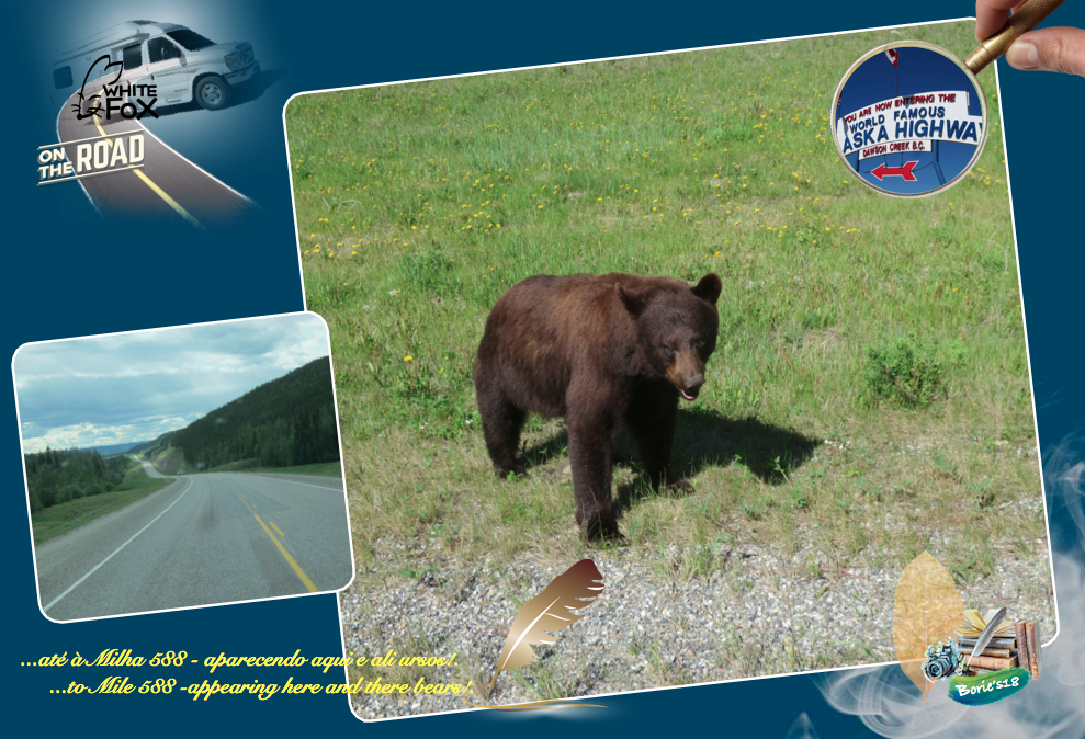
…até à Milha 588 – Algumas povoações, que vistas de perto, nos pareciam abandonadas, assim como algumas aberturas na floresta que nos pareciam pequenos aeroportos, aparecendo aqui e ali ursos, tanto pretos como castanhos, que teimavam em ocupar a estrada!. Por vezes surgem aqueles longos camiões, com dois e três atrelados, daqueles que não podem fazer manobras, só podem seguir em frente, que nos causam algum transtorno, pois em estradas de pedra miúda, os pneus fazem saltar pedras que partem vidros, mesmo a uma distância de centenas de metros, o que nos aconteceu, marcando o vidro da frente da nossa “White Fox” (nome da nossa caravana), em três locais, felizmente o vidro é à prova e, nada nos aconteceu, só o susto!. (To Mile 588 – Some villages, which we saw close to us, seemed abandoned, as well as some openings in the forest that seemed to us to be small airports, appearing here and there bears, both black and brown, who kept on occupying the road!. Sometimes these long trucks, with two and three trailers, come from those who can not make maneuvers, can only move on, which cause us some inconvenience, because on small stone roads, the tires make jumping rocks that break windows, even the a distance of hundreds of meters, what happened to us, marking the front glass of our “White Fox” (name of our caravan), in three places, fortunately the glass is proof and, nothing happened to us, just the scare)!.

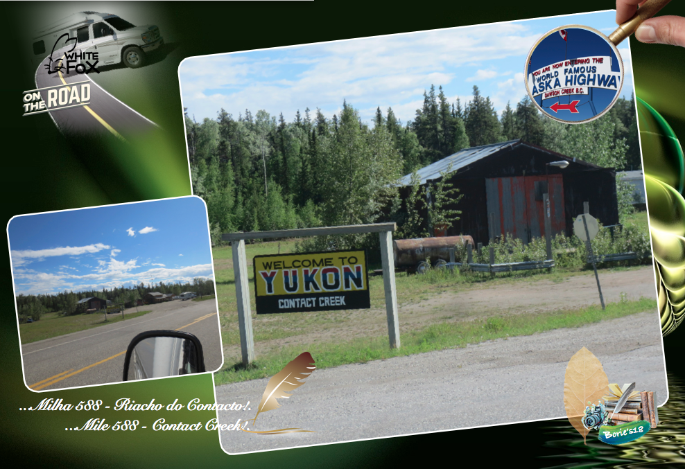
…Milha 588 – “Contact Creek” (Riacho do Contacto). Nome que foi dado a esta povoação, pelos soldados do 35.º Regimento do sul e pelo 340.º Regimento do norte, que se encontraram aqui em Setembro de 1942, completando o sector sul da histórica Estrada do Alaska!. Aqui existe um Posto de abastecimento de gasolina, onde também servem hamburgueres de carne de Búfalo!. (Mile 588 – “Contact Creek”!. This name was given to this settlement, by the soldiers of the 35th Southern Regiment and by the 340th Northern Regiment, who met here in September 1942, completing the southern sector of the historic Alaska Highway!. Here there is a gas station, where buffalo meat buffaloes are also served)!.

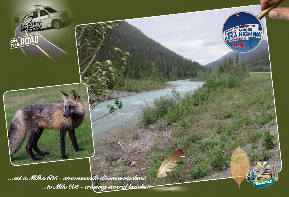
…até à Milha 605 – A estrada segue, com um cenário de muitas curvas, vales, atravessando diversos riachos com pontes em ferro, podendo observar a água revoltosa passando por baixo, ao longe montanhas com neve, continuação de muitos Búfalos atravessando a estrada!. Nós, parávamos muitas vezes, apreciando riachos selvagens, paisagens de montanha, animais selvagens, tirando fotos, ajudando motociclistas e outros veículos com problemas, não só cedendo gasolina, mas também rebocando, tirando de buracos fundos de lama!. (To Mile 605 – The road follows, with a backdrop of many curves, valleys, crossing several brooks with iron bridges, being able to observe the water revoltosa passing under, in the distance snowy mountains, continuation of many Buffaloes crossing the road!. We stopped often, enjoying wild streams, mountain scenery, wild animals, snapping pictures, helping motorcyclists and other troubled vehicles, not only handing over gasoline, but also towing, pulling muddy bottom holes)!.

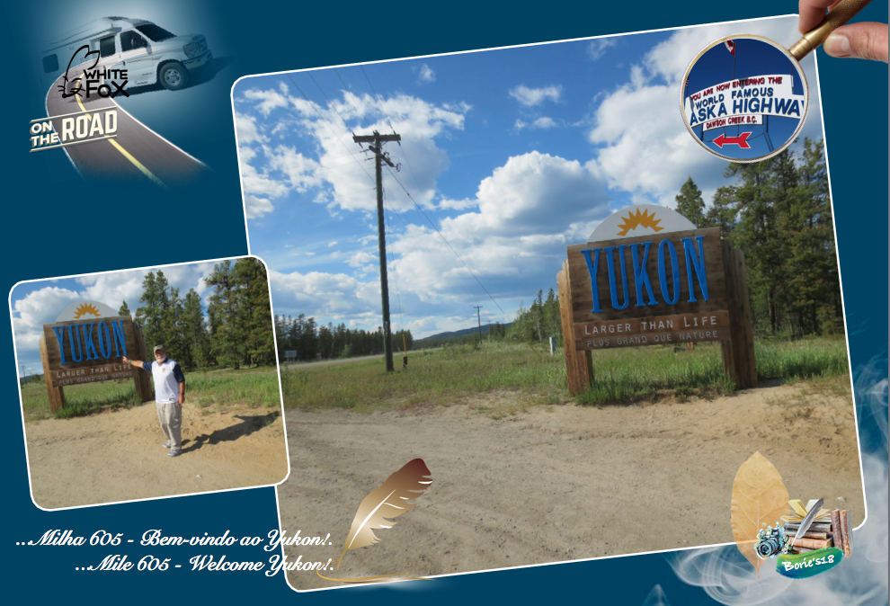
…Milha 605 – “Welcome Yukon” (Bem-vindo ao Yukon)!. A província do Yukon, é um território no noroeste do Canadá, é selvagem, montanhoso e pouco povoado!. O Parque Nacional Kluane e a sua Reserva, incluem o Mount Logan, o pico mais alto do Canadá, além de “glaciers” (neve acomulada em milhares, talvez milhões de anos), trilhas e o rio Alsek!. No extremo norte é o Parque Nacional de Ivvavik, com locais de nascimento protegidos, para os caribus de Porcupine!. No sul existem numerosos lagos alpinos alimentados pelos “glaciers” (neve acomulada em milhares, talvez milhões de anos), incluindo o lago Emerald corajosamente colorido!. Muito antes dos europeus, o Yukon central e do sul, era povoado por pessoas das Primeiras Nações, e a área escapou da glaciação!. Sites do significado arqueológico no Yukon possuem algumas das primeiras evidências da presença de ocupação humana na América do Norte!. Os sitios salvaguardam a história das primeiras pessoas e as primeiras Primeiras Nações do Yukon!. A cidade de Whitehorse é a capital territorial e a única cidade do Yukon!. (Mile 605 – “Welcome Yukon”!. The Yukon province, is a territory in northwest Canada, is wild, hilly and sparsely populated!. Kluane National Park and its Reserve include Mount Logan, the highest peak in Canada, as well as glaciers, trails and the Alsek!. At the northern end is the Ivvavik National Park, with protected birth places, for the porcupine caribou!. In the south there are numerous alpine lakes fed by “glaciers” (snow decked out in thousands, perhaps millions of years), including the boldly colored Emerald Lake!. Long before the Europeans, the central and southern Yukon was populated by First Nations people, and the area escaped from the glaciation!. Sites of archaeological significance in the Yukon possess some of the earliest evidence of the presence of human occupation in North America!. The sites safeguard the history of the first people and the first First Nations of the Yukon!. The city of Whitehorse is the territorial capital and the only city in the Yukon)!

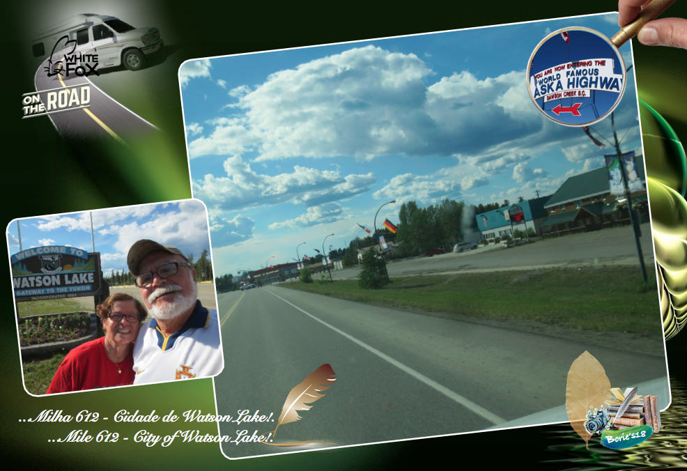
…Milha 612 – Cidade de Watson Lake (Lago Watson)!. Localizada na originalmente milha 635 na Histórica Estrada do Alaska, que recebeu o nome de Frank Watson, um caçador e prospector de origem americana, que se instalou na área no final do século XIX!. É o principal centro da pequena indústria madeireira no Yukon e tem sido um centro de serviços para o sector de mineração onde existem alguns restaurantes, estações de abastecimento de gasolina, uma loja de venda de alguns géneros de primeira necessidade para quem viaja, RV Parque, (onde pernoitámos), assim como um pequeno aeroporto!. (Mile 612 – City of Watson Lake!. Located on originally 635 mile on the Historic Alaska Highway, it was named after Frank Watson, a hunter and prospector of American origin, who settled in the area in the late nineteenth century!. It is the main hub of the small timber industry in the Yukon and has been a service center for the mining sector where there are some restaurants, gasoline filling stations, a grocery store selling some essentials for travelers, RV Park, (where we stayed), as well as a small airport)!.

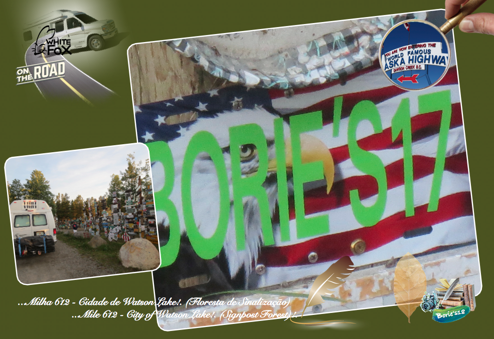
…as atracções turísticas na cidade de Watson Lake (Lago Watson) incluem o Signpost Forest (Floresta de Sinalização), onde querendo representar as nossas raízes, deixámos uma placa, assinalando a nossa passagem, que foi iniciado em 1942, por um soldado do Exército dos Estados Unidos, que se encontrava doente, e trabalhava na famosa Estrada do Alaska, com saudades da sua cidade natal, colocou um sinal com o nome de sua cidade natal e a distância!. Outros seguiram o exemplo e a tradição continua até hoje!. A partir de Agosto de 2010, existem mais de 76,000 sinais de vários tipos que retratam locais em todo o mundo!. (Tourist attractions in the city of Watson Lake include the Signpost Forest, where, in order to represent our roots, we left a plaque, marking our passage, which began in 1942, for a US Army soldier who was sick and worked on the famous Alaska Road, homesick for his hometown, placed a sign with the name of his home town and the distance!. Others have followed suit and tradition continues to this day!. As of August 2010, there are more than 76,000 signs of various types depicting locations around the world)!.

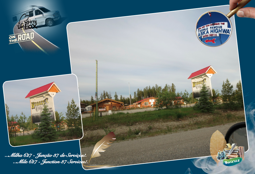
…Milha 627 – “Junction 37 Services” (Junção 37 de Serviços)!. É o extremo norte da Estrada Cassier, que vem do sul, que faz a sua intersecção à Estrada do Alaska!. A esta pequena povoação chamam-lhe “Nugget City” (Cidade das Pepitas), onde existem algumas atracções como por exemplo, um restaurante, Cabanas para dormir, RV parque, Loja de conveniência e prendas, Posto de venda de gasolina e assistência mecânica!. (Mile 627 – “Junction 37 Services”!. It is the northern end of the Cassier Road, which comes from the south, which makes its intersection to the Alaska Highway!. To this small town they call it “Nugget City”, where there are some attractions such as a restaurant, Sleeping cabins, RV park, Convenience store and gifts, Gas station and mechanical assistance)!.

…Milha 687 – “Rancheria”!. É uma pequenina povoação iniciada por mineiros oriundos da Califórnia e do México, que por aqui procuravam ouro, num riacho a que deram o nome de “Rio Rancheria”!. Originalmente é a Milha 710, e existe um conjunto de pequenas habitações onde se encontra uma Loja de Conveniência que vende refrigerantes, refeições ligeiras, gasolina, propane e outros artigos para viajantes!. Próximo, numa clareira aberta na floresta parece-nos um pequeno aeroporto, onde alguns helicópteros fazem manobras!. (Mile 687 – “Rancheria”!. It is a small town started by miners from California and Mexico, who were looking for gold here in a stream that they named “Rancheria River”!. Originally it is Mile 710, and there is a cluster of small homes where you will find a convenience store that sells soft drinks, light meals, gas, propane and other traveler items!. Nearby, in an open clearing in the forest looks like a small airport, where some helicopters do maneuvers)!.

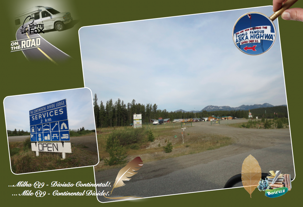
…Milha 699 – “Continental Divide” (Divisão Continental)!. Ponto que divide dois dos maiores sistemas de drenagem da América do Norte, que são as bacias hidrográficas do rio Yukon e do rio Mackenzie, fazendo com que a água que escorre para oeste a partir deste ponto forme o Rio Swift, continuando uma viagem para Noroeste de 2.300 milhas (3.680 km) até o Mar de Bering no Oceano Pacífico e, a água que drena para o leste forma o Rio Rancheria que deságua no mar de Beaufort, no Ocean Ártico, após uma jornada de 2.650 milhas (4.200 km)!. (Mile 699 – “Continental Divide”!. A point that divides two of the largest drainage systems in North America, which are the watersheds of the Yukon River and the Mackenzie River, causing the water that flows westward from this point to form the Swift River, continuing a trip to the Northwest from 2,300 miles (3,680 km) to the Bering Sea in the Pacific Ocean, and the water that drains east forms the Rancheria River that flows into the Beaufort Sea in the Arctic Ocean after a 2,650-mile (4,200 km) journey)!.

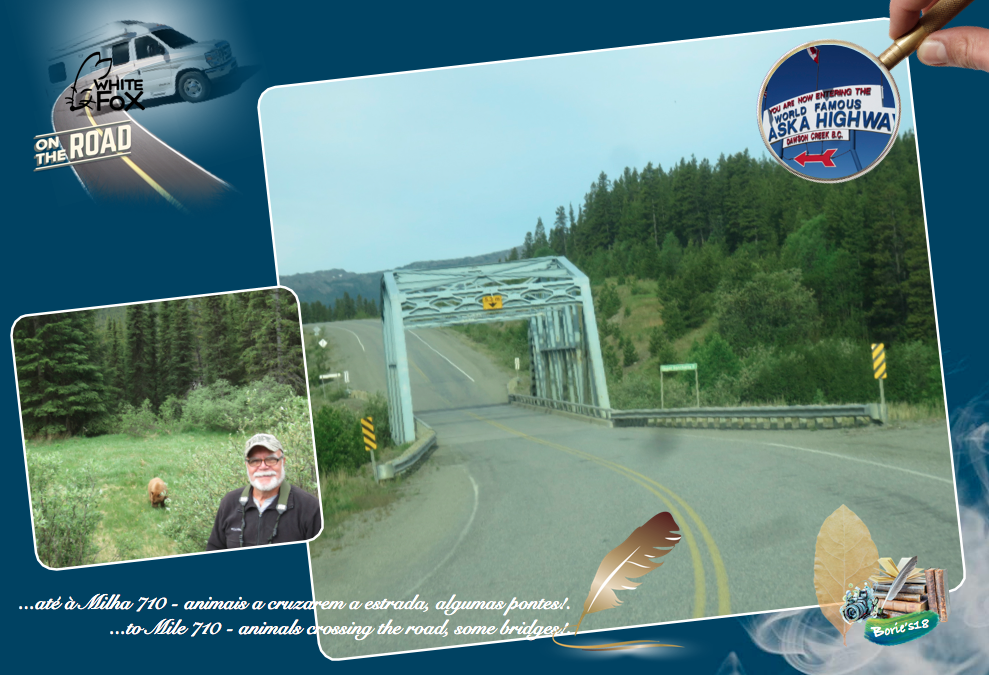
…até à Milha 710 – A estrada umas vezes continua encostada a precipícios, onde só pode passar um veículo de cada vez, com letreiros dizendo que podem cair pedras, outras vezes suave, longas retas, animais a cruzarem a estrada, algumas pontes, ainda do tempo inicial da construção da estrada, sobre vários rios e riachos, com a água revoltosa correndo por baixo!. (To Mile 710 – The road sometimes remains against cliffs, where only one vehicle can pass at a time, with signs saying that stones may fall, sometimes soft, long straight lines, animals crossing the road, some bridges , still of the initial time of the construction of the road, on several rivers and streams, with the creepy water running underneath)!.

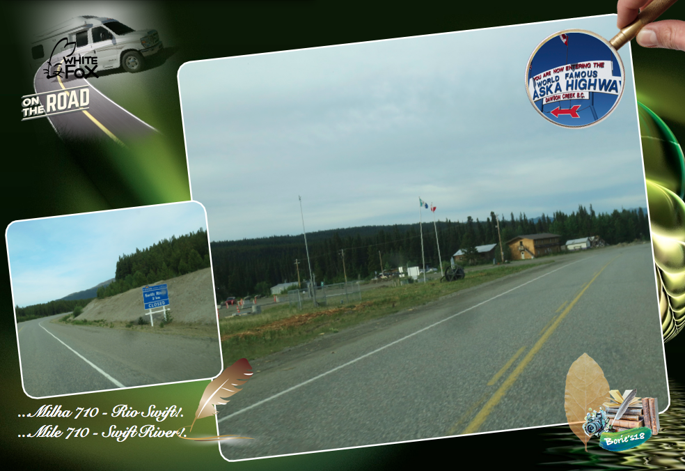
…Milha 710 – “Swift River” (Rio Swift)!. Um pouco antes deste local existe um anúncio informativo de estrada, dizendo que existe o histórico “Swift River Lodge”, parámos e fomos verificar!. Tal como o anúncio dizia, estava encerrado, parecendo-nos abandonado, pois pequenas várias árvores cresciam em todo o lado, mesmo cobrindo o anúncio que continuava lá dizendo que ofereciam gás, quartos, refeições, um armazém geral e parque para Rv’s e camiões! (Mile 710 – “Swift River”!. Just before this place there is a road ad, saying there is the historic “Swift River Lodge”, we stopped and went to check it out!. As the ad said, it was closed, looking abandoned, as small trees grew everywhere, even covering the advertisement that kept saying that they offered gas, rooms, meals, a general store and park for RVs and trucks)!.

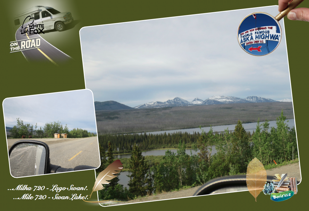
…Milha 720 – “Swan Lake” (Lago Swan)!. É uma área de descanso com vista para o sul, onde existe casa de banho externa e recipientes para colocar o lixo!. Da beira do lago, onde a água é cristalina, avista-se para o sul todo o lago, com uma montanha em forma de pirâmide ao sul, que é o “Simpson Peack” (Pico Simpson)!. (Mile 720 – “Swan Lake”!. It is a rest area with a view to the south, where there is an external bathroom and containers to put the garbage!. From the edge of the lake, where the water is crystal clear, you can see to the south the whole lake, with a pyramid shaped mountain to the south, which is the “Simpson Peack”)!.

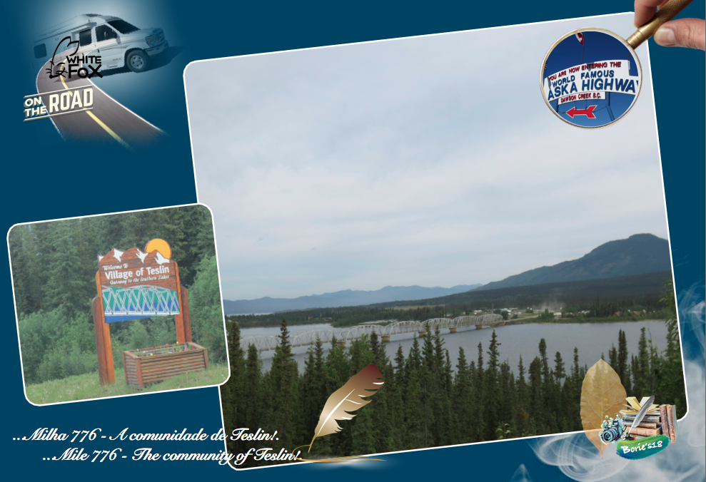
…Milha 776 – Teslin!. A comunidade de Teslin, está marcada originalmente pela Milha 804, situada na estrada do Alaska, ao longo do Lago Teslin. A Hudson’s Bay Company estabeleceu uma pequena posição comercial em Teslin em 1903, e Teslin é o lar da primeira nação Teslin Inland Tlingit First, e o nome veio de uma palavra Tlingit “Teslintoo”. Teslin tem uma das maiores populações nativas do Yukon. Grande parte da subsistência da comunidade gira em torno da caça tradicional, usando por vezes ratoeiras e da pesca!. Parámos antes, num lindo miradouro sobre o lago de Teslin, onde se pode admirar a ponte e a povoação!. (Mile 776 – Teslin!. The community of Teslin is originally marked by Mile 804, located on the Alaska Highway, along Lake Teslin!. The Hudson’s Bay Company established a small trading position in Teslin in 1903, and Teslin is home to the first nation Teslin Inland Tlingit First, and the name came from a Tlingit word “Teslintoo”!. Teslin has one of the largest native populations of the Yukon. Much of the livelihood of the community revolves around traditional hunting, sometimes using traps and fishing!. We stopped before, on a beautiful belvedere over the lake of Teslin, where you can admire the bridge and the village)!.

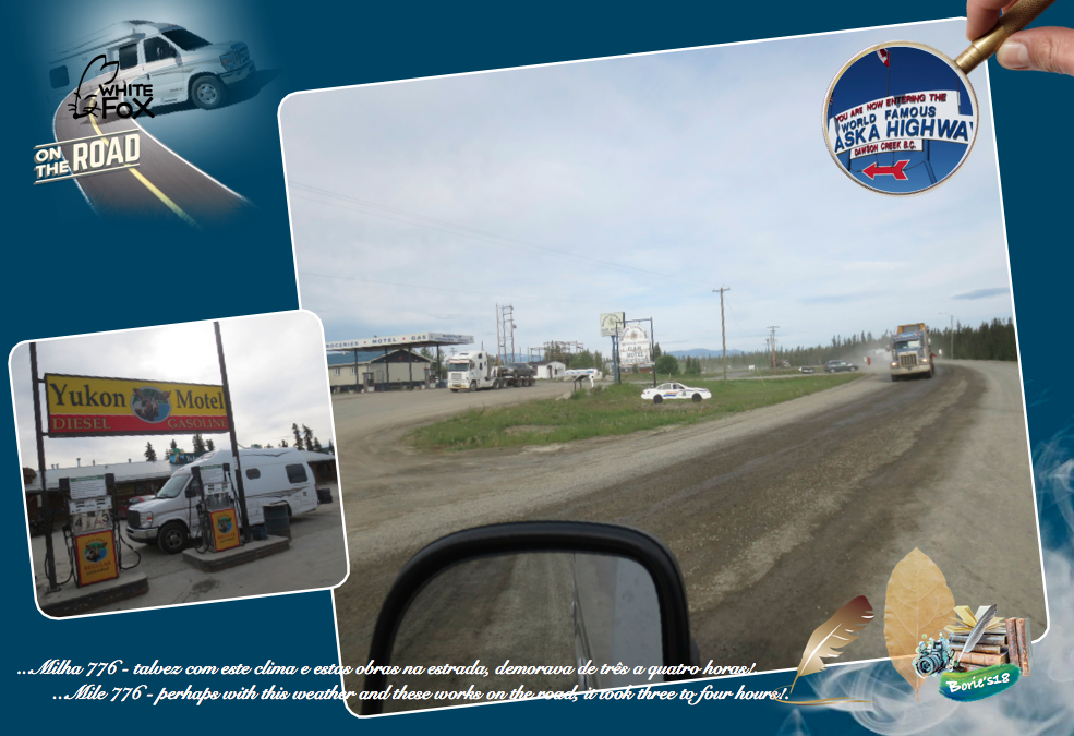
…seguindo, depois da ponte, havia um museu, que na altura estava fechado, cartazes a convidar a ir pescar e passear no lago, mas a nossa atenção era uma estação de serviço, que encontrámos, onde a pessoa que atendia, dentro do estabelecimento, nos pediu o cartão de crédito, verificou duas ou três vezes, abriu a estação número 2, enchemos a gasolina que desejávamos, fez a transação, assinámos o papel e, perguntando nós qual a distância para a cidade de Whitehorse, que era o nosso próximo destino, logo nos respondeu, com um sorriso malicioso, mencionando o nosso sotaque de voz, que devíamos de ser oriundos dos “States”, que nesta zona, não importavam as distâncias, era o tempo que podia demorar, talvez com este clima e estas obras na estrada, demorava de três a quatro horas!. (Following, after the bridge, there was a museum, which at the time was closed, posters inviting to go fishing and stroll in the lake, but our attention was a service station, which we found, where the person who attended, inside of the establishment, asked us for the credit card, checked it two or three times, opened station number 2, filled the gas we wished, made the transaction, signed the paper and, wondering what distance to the town of Whitehorse, it was our next destination, he soon replied with a malicious smile, mentioning our voice accent, that we should come from the States, which in this area, no matter the distances, was the time that could take, perhaps with this weather and these works on the road, it took three to four hours)!.

…Milha 836 – Jake’s Corner” (Canto do Jake)!. É um lugar bastante popular, onde podemos comprar, água, café, gás e outras pequenas coisas que os viajantes de estrada normalmente precisam, que se situa no extremo norte da estrada Tagist, que vem do sul, que faz a sua intersecção à estrada do Alaska, onde no ano de 1942, o Corpo de Engenheiros do Exército dos EUA montou um campo de construção no ano de 1942, sob o comando do Capitão Jacobson, dando assim o nome ao Canto do Jake!. No entanto, o nome também é atribuído a Jake Jackson, um nativo índio Teslin, que acampava nesta área a caminho da vila de Carcross!. (Mile 836 – “Jake’s Corner”!. It is a very popular place where we can buy water, coffee, gas, and other little things that road travelers usually need, which is located at the north end of the Tagist road, which comes from the south, which makes its intersection Alaska Highway, where in 1942, the US Army Corps of Engineers set up a construction field in 1942, under the command of Captain Jacobson, thus naming Jake’s Corner. However, the name is also attributed to Jake Jackson, a native Indian Teslin, who camped in this area on his way to the village of Carcross)!.

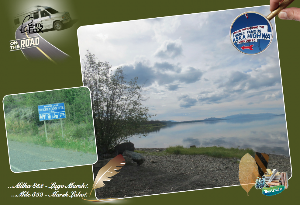
…Milha 852 – “Marsh Lake” (Lago Marsh)!. O Lago Marsh é parte do sistema do Rio Yukon, com aproximadamente 20 milhas (32 km) de comprimento, que nos oferece deslumbrantes vistas a oeste durante algumas milhas de viajem, em direcção ao norte!. (Mile 852 – “Marsh Lake”!. Marsh Lake is part of the Yukon River system, approximately 20 miles (32 km) long, which gives us breathtaking views to the west for a few miles traveling, heading north)!.

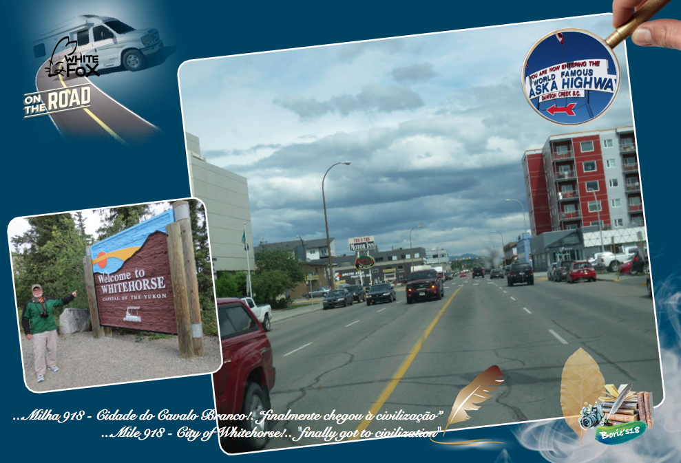
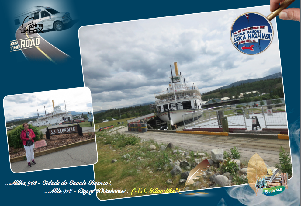
…Milha 918 – Cidade de Whitehorse (Cavalo Branco)!. O viajante do histórico Alaska Highway (Estrada do Alaska), quando chega à cidade de Whitehorse, pára o seu veículo, abre os braços e diz que, “finalmente chegou à civilização”!. A cidade tem o que normalmente se necessita para a sobrevivência, além de um Centro de Visitas muito funcional, prestando informação com eficiência e, tem sinal de internet!. Nós deambulámos pela cidade e visitámos um barco, que nos parece um museu, faz-nos lembrar os primeiros prostectores de ouro que apareceram na região, nas suas aventuras pelo Rio Yukon!. Valeu a pena a sua visita, chama-se “S.S. Klondike”!. E não podemos esquecer que Whitehorse, conforme relatado por “Guinness World Records”, é a cidade com a menor poluição do ar no mundo!. (Mile 918 – City of Whitehorse!. The traveler on the historic Alaska Highway, when he arrives in the city of Whitehorse, stops his vehicle, opens his arms and says, “finally got to civilization”!. The city has what is normally needed for survival, in addition to a very functional Visitor Center, providing information efficiently and has internet signal!. We roamed the city and visited a boat, which looks like a museum, reminds us of the first gold prosecutors that appeared in the region, in their adventures on the Yukon River!. It was worth your visit, it is called “S.S. Klondike”!. And let’s not forget that Whitehorse, as reported by “Guinness World Records,” is the city with the least air pollution in the world)!.

…Whitehorse é a capital, maior e única cidade do Yukon, e a maior cidade do norte do Canadá. As áreas do centro e Riverside ocupam ambas as margens do rio Yukon, que se origina na Columbia Britânica e encontra o Mar de Bering no Alaska. A cidade recebeu o nome dos “Rapidos dos Cavalos Brancos” pela semelhança com a crina de um cavalo branco, perto de Miles Canyon, antes que o rio fosse reprezado. A descoberta de ouro no Klondike, em Agosto de 1896, desencadeou uma grande mudança nos padrões históricos da região, e os primeiros prospectores usaram o Passe Chilkoot, mas, em Julho de 1897, as multidões de pessoas, desejosos de ficarem ricos com a procura do ouro, chegaram por navio a vapor e, estavam acampando em “Whitehorse”!. (Whitehorse is the capital, the largest and only city in the Yukon, and the largest city in northern Canada!. The downtown and Riverside areas occupy both banks of the Yukon River, which originates in British Columbia and meets the Bering Sea in Alaska!. The town was named after the “White Horse Rapids” for its resemblance to white horsehair near Miles Canyon before the river was reprimanded!. The discovery of gold at the Klondike in August 1896 unleashed a major change in the region’s historical patterns, and the first prospectors used the Chilkoot Pass, but in July 1897 the multitudes of people, desirous of getting rich with the demand of gold, arrived by steamship, and were camping in “Whitehorse”)!.

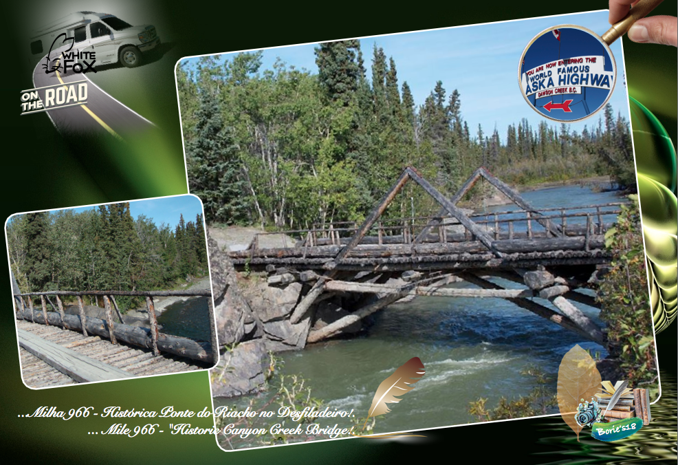
…Milha 966 – “Historic Canyon Creek Bridge” (Histórica Ponte do Riacho no Desfiladeiro)!. É uma área de descanso, com telheiros, onde estão painéis interpretativos sobre a histórica desta ponte, que também é um local excelente para tirar fotos!. A história diz que, uma corrida ao ouro no Rio Alsek, trouxe uma debandada de mineiros para esta área, onde imediatamente foi construída uma estrada para carroças a partir da cidade de Whitehorse!. De seguida, construíram uma ponte com a madeira das árvores que por ali havia, sobre o riacho que passava naquele desfiladeiro!. Esta maravilhosa ponte sobreviveu a fortes inundações de tráfego e altas enchurradas!. No ano de 1942, durante a construção da Estrada do Alaska, foi desmontada e, uma nova precisamente igual construída em 18 dias, deixando-a naquele preciso local, enquando uma ponte permanente, para a passagem da nova estrada, foi construída mais a jusante!. Periódicamente recebe reparações de manutenção, para manter o seu maravilhoso aspecto!. (Mile 966 – “Historic Canyon Creek Bridge”!. It is a rest area, with sheds, where are interpretative panels on the history of this bridge, which is also a great place to take pictures!. The story goes that a gold rush on the Alsek River brought a stampede of miners to this area, where a carriage road was immediately built from the town of Whitehorse!. Then they built a bridge with the wood of the trees that were there, over the creek that passed in that gorge!. This wonderful bridge survived heavy floods of traffic and high spills!. In 1942, during the construction of the Alaska Highway, it was dismantled, and a new one precisely built in 18 days, leaving it at that precise location, while a permanent bridge for the passage of the new road, was built further downstream!. Periodically you get maintenance repairs, to maintain your wonderful look)!.

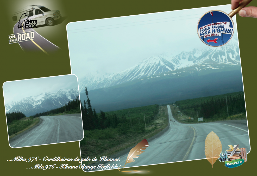
…Milha 976 – “Kluane Range Icefields” (Cordilheiras de gelo de Kluane)!. Viajando na estrada, podemos observar uma vista impressionante das cordilheiras de gelo nas montanhas!. (Mile 976 – “Kluane Range Icefields”!. Traveling on the road, we can observe an impressive view of the ice ridge in the mountains)!.

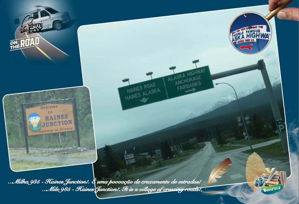
…Milha 985 – Haines Junction!. É uma povoação de cruzamento de estradas!. Tem quase todas as facilidades que um viajante de estrada necessita, incluindo sinalização, indicando diversas rotas a seguir!. Indo em direcção ao norte do estado do Alaska mudamos de direção!. Um pouco para norte, as montanhas em redor ainda têm neve, a sua história diz que, por cerca de dois mil anos, as pessoas do sul da Tutchone tiveram campos de caça e, caça sazonais na área da actual Haines Junction. Era uma vantagem para as pessoas da Tutchone usarem umas casotas levantadas, muito acima do chão, para armazenar alimentos durante todo o ano, ou temporariamente enquanto caçavam e pescavam na área!. (Mile 985 – Haines Junction!. It is a village of crossing roads!. It has almost all the facilities that a road traveler needs, including signaling, indicating several routes to follow!. Going north of the state of Alaska we change direction!. A little north, the surrounding mountains still have snow, its history says that for about two thousand years, the people of southern Tutchone have had hunting and seasonal hunting grounds in the area of present-day Haines Junction!. It was an advantage for the people of Tutchone to use raised hovels, high above the ground, to store food all year round, or temporarily while hunting and fishing in the area)!.

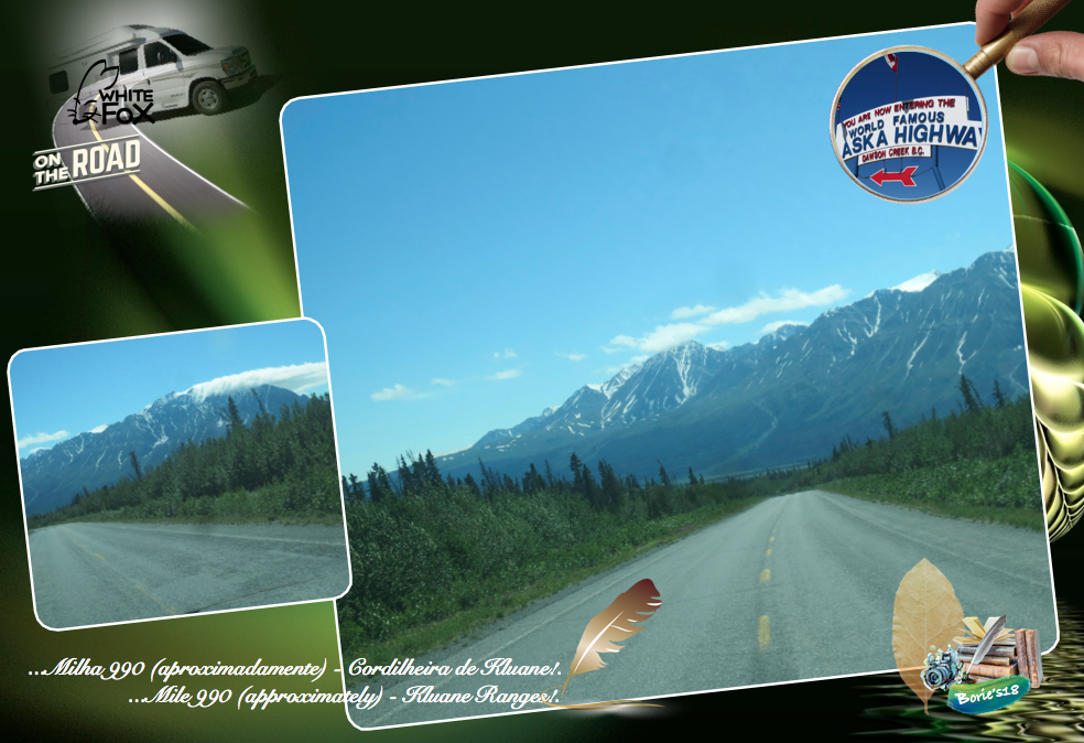
…Milha 990 (aproximadamente) – “Kluane Ranges” (Cordilheira de Kluane)!. Vista maravilhosa a sudoeste da Cordilheira Kluane, coberta de neve com a Estrada do Alaska a seguir paralela à Cordilheira desde a povoação de Haines Junction, apresentando uma corrente quase ininterrupta de montanhas com 8.000 pés (2.450m) de altura, interrompida por apenas alguns grandes vales, cortados pelos “glaciers” (neve acomulada em milhares, talvez milhões de anos), que alimentam alguns rios ou ribeiros!. (Mile 990 (approximately) – “Kluane Ranges”!. Wonderful view southwest of the snow-capped Kluane Mountain Range with the Alaska Highway parallel to the Cordillera from the village of Haines Junction, featuring an almost unbroken chain of 8,000-foot (2,450m) high mountains interrupted by only a few large valleys, cut by the glaciers (snow embedded in thousands, perhaps millions of years), which feed some rivers or streams)!.

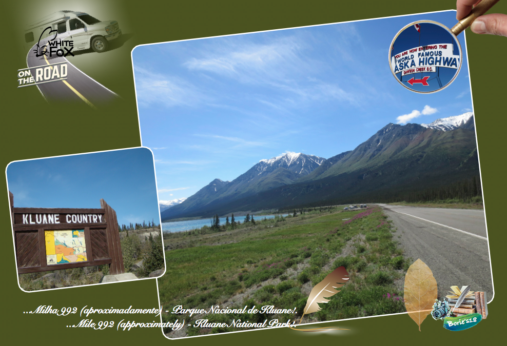
…Milha 992 (aproximadamente) – “Kluane National Park” (Parque Nacional de Kluane)!. É uma reserva, no território de Yukon para os amantes do ar livre, que podem apreciar as maravilhas deste parque!. A sua beleza selvagem é impressionante fazendo com que o Parque Nacional e Reserva de Kluane, fosse declarado Património da Humanidade pela UNESCO, no ano de 1979! Abriga 17 dos 20 picos mais altos de todo o Canadá, sendo o maior campo de gelo alpino não polar do mundo, formando o interior selvagem deste parque, que nos mostra vistas deslumbrantes, que revelam enormes cadeias de montanhas, glaciares e campos de gelo à distância!. (Mile 992 (approximately) – “Kluane National Park”!. It is a reserve, in the Yukon Territory for the outdoors lovers, who can appreciate the wonders of this park!. Its wild beauty is impressive, making Kluane National Park and Preserve a World Heritage Site by UNESCO in 1979!. It houses 17 of the 20 highest peaks in all of Canada, being the largest non-polar alpine ice field in the world, forming the wilderness of this park, which shows us breathtaking vistas revealing huge mountain ranges, glaciers and distance!.

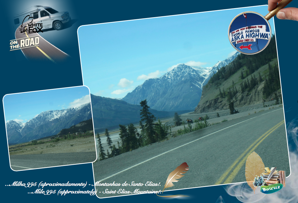
…Milha 995 (aproximadamente) – “Saint Elias Mountains” (Montanhas de Santo Elias)!. Viajando na estrada, mesmo circulando, sem sair do veículo, podemos admirar uma parte externa das Montanhas de St. Elias a oeste, que são um conjunto de montanhas que, compreendem a maior cadeia de montanhas costeiras do mundo, com o Monte Logan, reivindicando o primeiro lugar com 19.850 pés (cerca de 5.000m), perdendo apenas para a montanha de Denali no estado do Alasca!. (Mile 995 (approximately) – “Saint Elias Mountains”!. Traveling on the road, even while driving, without leaving the vehicle, we can admire an external part of the St. Elias Mountains to the west, which are a set of mountains that comprise the largest chain of coastal mountains in the world, with Mount Logan, claiming the first place with 19,850 feet (about 5,000m), second only to Denali Mountain in the state of Alaska)!.

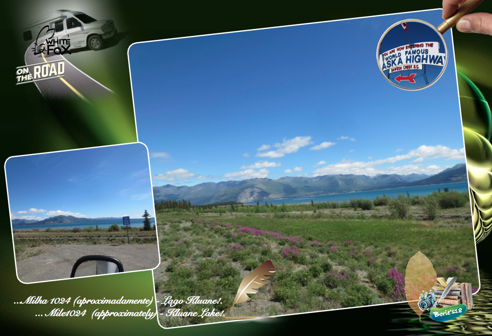
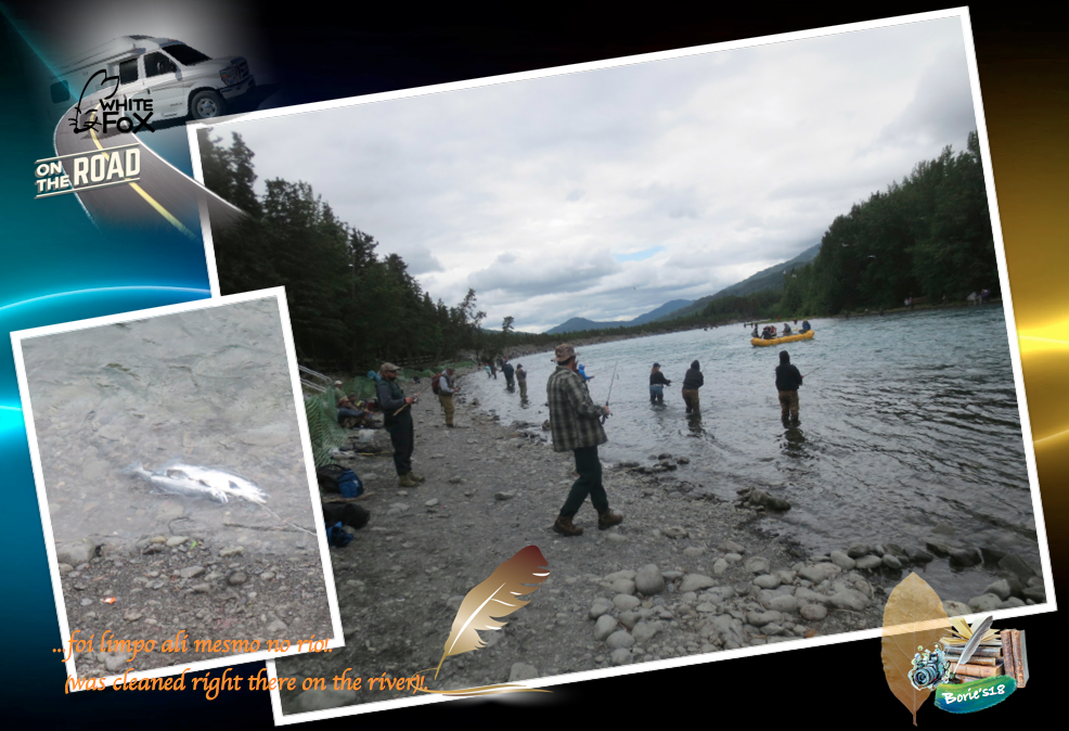
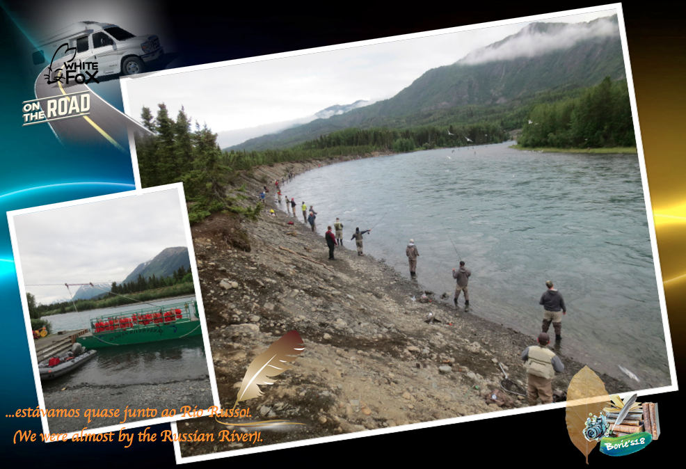
…Milha 1024 (aproximadamente) – “Kluane Lake” (Lago Kluane)!. A estrada segue a maior parte da fronteira sul do Lago Kluane, oferecendo lindas vistas do lago!. É o maior lago contido inteiramente dentro do território do Yukon, com aproximadamente 158 sq milhas (408 km2) e 50 milhas (81 km) de comprimento!. Até ao ano de 2016, foi alimentado pelo A’ay Chu (rio Slims) que era composto por água do degelo do Glaciar Kaskawulsh, localizado dentro do Parque Nacional de Kluane!. Drena para o rio Kluane, cujas águas correm para o rio Donjek, o rio White, o rio Yukon e, por fim, o mar de Bering!. É muito procurado para a pesca, pois tem uma alta densidade de grandes trutas de lago, assim como peixe branco!. (Mile1024 (approximately) – “Kluane Lake”!. The road follows most of the southern border of Lake Kluane, offering beautiful views of the lake !. It is the largest lake contained entirely within the territory of the Yukon, with approximately 158 sq miles (408 km2) and 50 miles (81 km) in length!. By the year 2016, it was fed by the A’ay Chu (River Slims) which was composed of water from the melting of the Kaskawulsh Glacier, located within the Kluane National Park!. Drain into the Kluane River, whose waters flow into the Donjek River, the White River, the Yukon River, and finally the Bering Sea!. It is highly sought after for fishing as it has a high density of large lake trout as well as whitefish !.

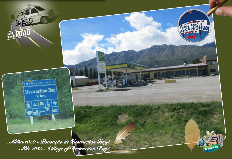
…Milha 1050 – Povoação de Destruction Bay!. É uma povoação que por certo nasceu e cresceu ao lado da Histórica Estrada do Alaska e, do Lago Kluane. É muito popular nos viajantes desta famosa estrada, pois tem onde dormir, fazer refeições e reparação de veículos!. (Mile 1050 – Village of Destruction Bay!. It is a village that was born and grew up right next to the Historic Alaska Highway and Lake Kluane. It is very popular with travelers of this famous road, because it has where to sleep, make meals and repair vehicles)!.

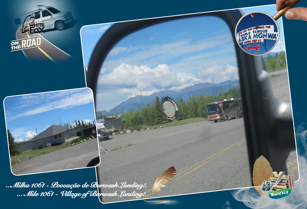
…Milha 1061 – Povoação de Burwash Landing!. O local actual de Burwash Landing, foi usado pela primeira vez como um acampamento de verão pelos Southern Tutchone Athabascans, até que um posto de comércio foi construído no início dos anos 1900, pelos irmãos Jacquot. É o lar do Museu Kluane de História Natural e da primeira Nação Kluane, e também o lar do maior prato de pesquizar ouro do mundo, junto à qual tirámos algumas fotos!. Tem um museu e podemos comprar alguns géneros de alimentação, assim como gasolina!. (Mile 1061 – Village of Burwash Landing!. The current site of Burwash Landing, was first used as a summer camp by the Southern Tutchone Athabascans, until a trading post was built in the early 1900s by the Jacquot brothers. It is home to the Kluane Museum of Natural History and the first Kluane Nation, and also home to the world’s largest gold-digging dish, along with some photos! It has a museum and we can buy some food, as well as gasoline)!.

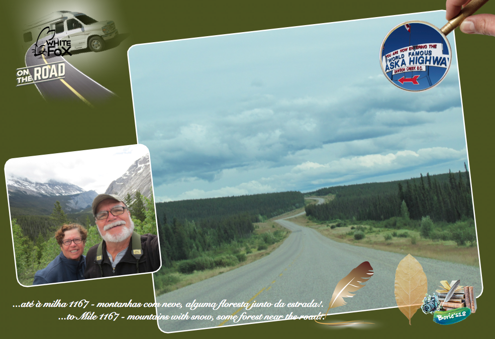
…até à milha 1167 – O cenário é de lagos, pequenos rios, montanhas com neve, alguma floresta junto da estrada, com animais atravessando a estrada, principalmente ursos castanhos!. (To Mile 1167 – The scenery is of lakes, small rivers, mountains with snow, some forest near the road, with animals crossing the road, mainly brown bears)!.

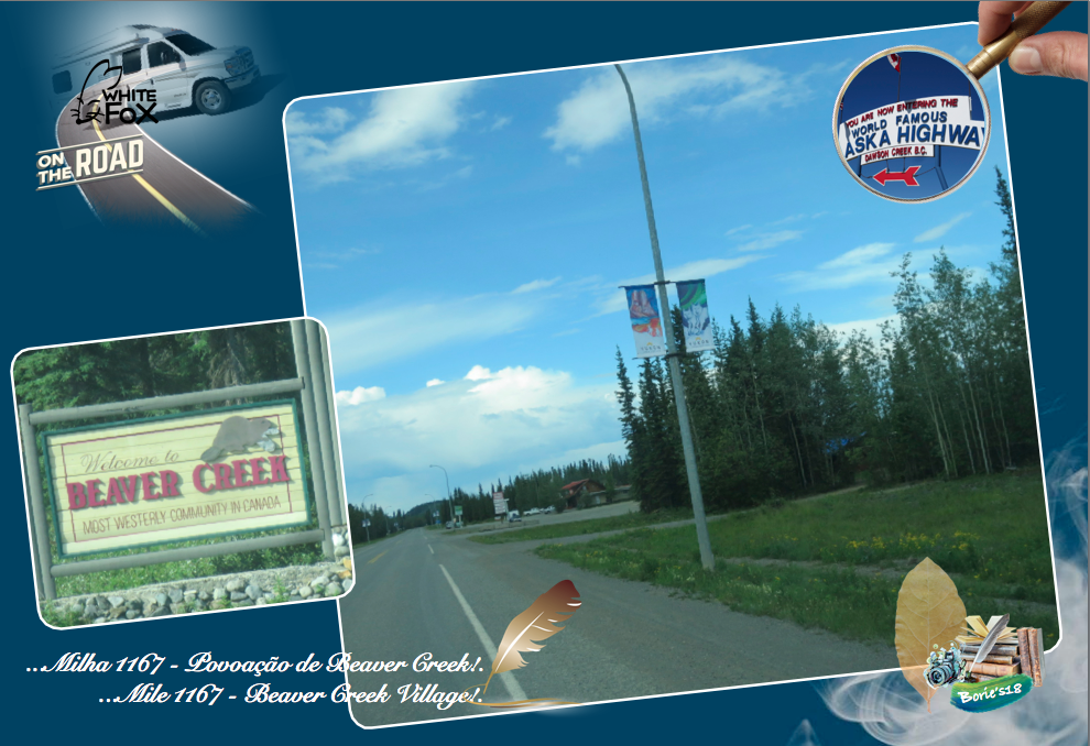
…Milha 1167 – Povoação de Beaver Creek!. É uma povoação fronteiriça, que se situa próximo da “Alcan-Beaver Creek Border Crossing” (Passagem fronteiriça de Alcan-Beaver Creek)!. É a comunidade mais ocidental do Canadá, e os principais empregadores são a Agência dos Serviços da Fronteira do Canadá!. Uma curiosidade, a Estação da Agência de Serviços da Fronteira do Canadá, é a mais distante do cruzamento de fronteira de qualquer estação aduaneira canadense, a uma distância de 17,8 milhas (28,6 km) e, pelo menos até a década de 1990, alguns indivíduos viviam na “terra de ninguém” entre a fronteira e a estação de alfândega. Antes de 1983, a estação de alfândega estava localizada no meio da comunidade, com a confusão resultante, pois indivíduos que passavam sem parar, e os moradores com um novo veículo não eram reconhecidos enquanto conduziam!. (Mile 1167 – Beaver Creek Village!. It is a border town, which is located near the Alcan-Beaver Creek Border Crossing!. It is the most western community in Canada, and the main employers are the Canadian Border Services Agency!. A curiosity, the Canada Border Services Agency Station, is the furthest from the border crossings of any Canadian customs station, at a distance of 17.8 miles (28.6 km) and, at least until the 1990, some individuals lived in the “no man’s land” between the border and the customs station!. Prior to 1983, the customs station was located in the middle of the community, with the resulting confusion, as individuals passed by without stopping, and residents with a new vehicle were not recognized while driving)!.

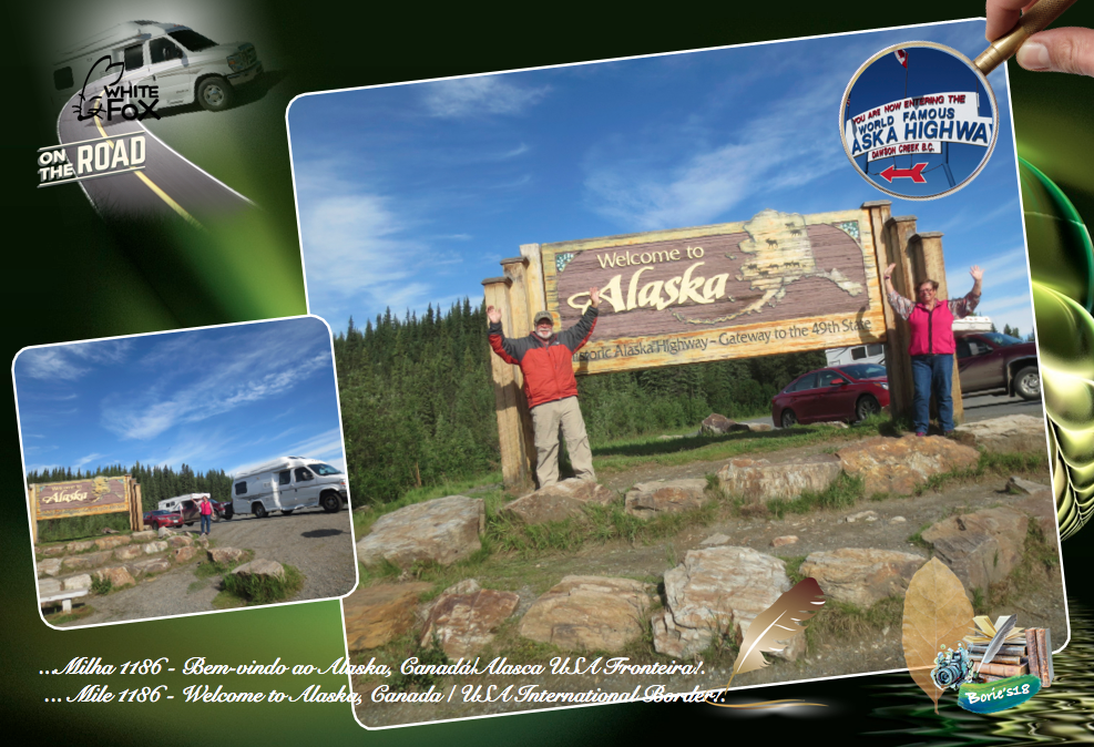
…Milha 1186 – Welcome to Alaska (Bem-vindo ao Alaska), Canada/USA International Border (Canadá/Alasca USA Fronteira)!. É uma paragem que, não sendo obrigatória, nos merece uma visita, onde se pode admirar os marcos de fronteira, placas indicando a entrada no estado do Alaska, assim como alguma informação e história de ambos os países amigos, e claro, para tirar fotografias!. A Estação de Alfândega e Proteção de Fronteiras dos EUA será encontrada umas milhas mais à frente, mais propriamente na milha 1221 e, marca oficialmente sua entrada em solo americano!. (Mile1186 – Welcome to Alaska, Canada / USA International Border!. It is a stop that, not being obligatory, deserves a visit, where you can admire the border landmarks, signs indicating the entrance in the state of Alaska, as well as some information and history of both countries friends, and of course, to take photographs!. The US Customs and Border Protection Station will be found a few miles further, more precisely at mile 1221, and officially marks its entry into American soil)!.

…até à milha 1280 – A estrada está em melhor estado de conservação, a velocidade é controlada em milhas, existem algumas localidades onde se vende entre outras coisas gasolina medida em galões, a um preço mais em conta!. Também podemos parar no Refúgio Nacional da Vida Selvagem da localidade Tetlin, onde os apreciadores de aves se deliciam com a paisagem dinâmica do Refúgio Nacional de Vida Selvagem de Tetlin, numa área no alto vale do rio Tanana, composta por extensas florestas, pântanos, tundras, lagos e rios glaciais, com um refúgio cercado pelas montanhas cobertas de neve da cordilheira do Alaska!. É uma rota, quase obrigatória e muito importante para aves que migram de, e para o Canadá, incluindo gansos, patos, cisnes, e outras aves de arribação!. O refúgio é pontilhado de mamíferos como rebanhos de ovelhas, alces e caribus!. (Up to Mile 1280 – The road is in better state of conservation, speed is controlled in miles, there are some localities where it sells among other things gasoline measured in gallons, at a price more in account!. We can also stop at the National Wildlife Refuge of Tetlin, where birdwatchers delight in the dynamic landscape of the Tetlin National Wildlife Refuge, in an area in the high valley of the Tanana River, made up of extensive forests, marshes, tundra, lakes and glacial rivers, with a refuge surrounded by the snow-capped mountains of the Alaska Range!. It is a route, almost mandatory and very important for birds migrating to and from Canada, including geese, ducks, swans, and other birds! The refuge is dotted with mammals like flocks of sheep, moose and caribou)!.

…Milha 1280 – Cidade de Tok, já no Alaska!. Tok é o lar das boas-vindas não oficial do Alaska!. Apelidada de “Capital do Cão de Trenó do Alasca”, ficando perto da fronteira com o Canadá, há muito tempo é considerada um paraíso para os viajantes desde sua fundação em 1942, claro, graças à construção da Estrada do Alaska!. O centro de visitantes, assim como restaurantes e parques de RV, são fáceis de encontrar!. Aqui, podemos dizer que, “já chegámos ao Alaska”!. Portanto, que mais vamos ver?. Estamos na cidade de Tok, que se encontra numa planície aluvial muito grande e plana, do Vale Tanana, entre o Rio Tanana e o Alaska Range, que é uma cordilheira de montanhas, numa importante junção da Estrada do Alaska!. (Mile 1280 – City of Tok, already in Alaska!. Tok is the home of the unofficial welcome from Alaska!. Nicknamed the “Alaskan Sleigh Dog Capital”, staying near the Canadian border, it has long been considered a haven for travelers since its founding in 1942, of course, thanks to the construction of the Alaska Highway!. The visitor center, as well as restaurants and RV parks, are easy to find!. Here, we can say that, “we have already reached Alaska”!. So, what else are we going to see?. We are in the town of Tok, which lies on a very large, flat alluvial plain of the Tanana Valley, between the Tanana River and the Alaska Range, which is a mountain range at an important junction of the Alaska Highway)!.

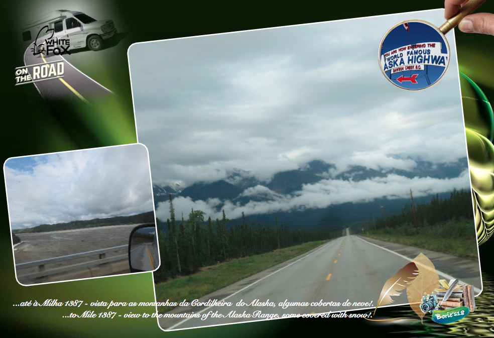
…até à Milha 1387 – Viajando no sentido norte, podemos parar por volta da milha 1309, e apreciar uma área de estacionamento pavimentada com mesas de piquenique, banheiros, locais próprios para colocar o lixo e um bom local, com uma maravilhosa vista, para as montanhas da Cordilheira do Alaska, algumas cobertas de neve!. Mais à frente, atravessamos diversas artísticas pontes construídas em ferro, sobre alguns rios, que formam grandes áreas de areal, claro, continuando a ver as montanhas da Cordilheira do Alaska!. (To Mile 1387 – Traveling north, we can stop around mile 1309, and enjoy a paved parking area with picnic tables, restrooms, garbage disposal sites and a good location with a wonderful view, to the mountains of the Alaska Range, some covered with snow!. Further on, we cross several artistic bridges built in iron, over some rivers, which form large areas of sandy, clear, continuing to see the mountains of the Alaska Range)!.

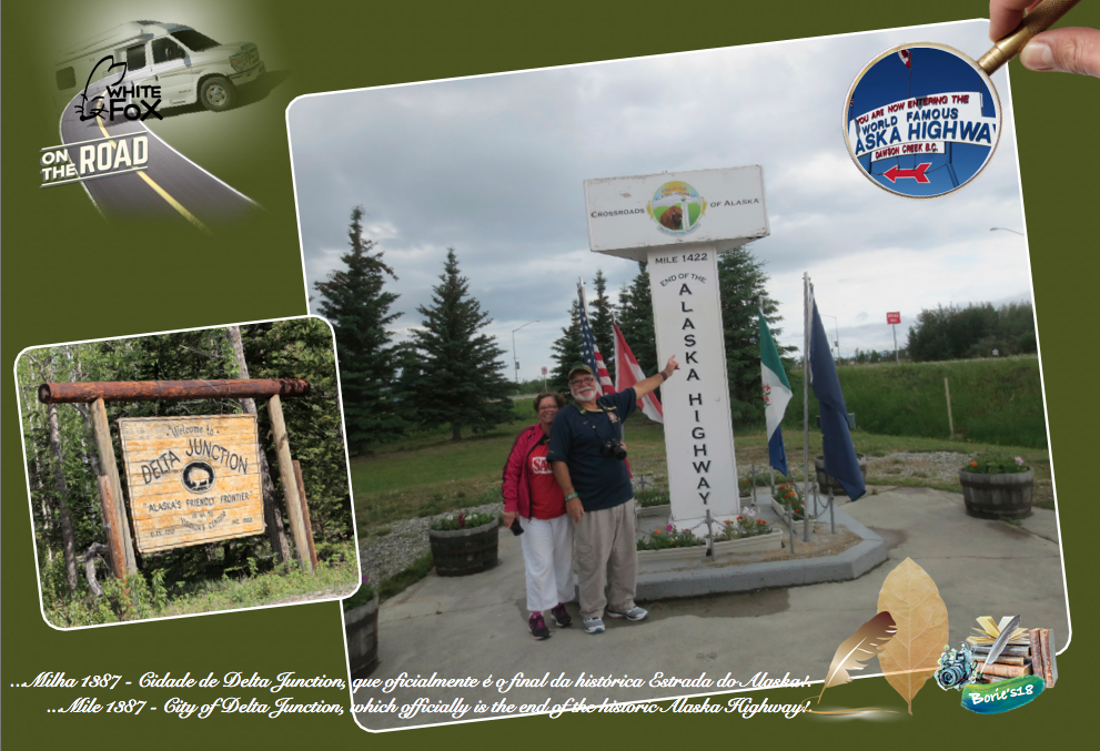
…Milha 1387 – Cidade de Delta Junction!. Por último, mas não menos importante, chegámos à cidade de Delta Junction, que oficialmente é o final da histórica Estrada do Alaska!. No entanto a estrada segue em direcção ao norte, como nome de Estrada Richardson, que assume o controle, trazendo frotas de passageiros para a cidade de Fairbanks, que alguns historiadores dizem que é lá que termina o hoje histórico, “Alaska Highway” (Estrada do Alaska), outros dizem que é na povoação de Big Delta, que também é ao norte, mas mais próxima!. (Mile 1387 – City of Delta Junction!. Last but not least, we came to the city of Delta Junction, which officially is the end of the historic Alaska Highway!. However the road continues northward, as the name of the Richardson Road, which takes control, bringing passenger fleets to the city of Fairbanks, which some historians say is the end of today’s historic, “Alaska Highway”, others say it is in the village of Big Delta, which is also to the north, but closer)!.

…e, para terminar é, “Melhor ver algo uma vez, do que ouvir ou ler sobre isso, um milhão de vezes”!. (And to conclude is, “Better to see something once, than to hear or read about it, a million times”)!.

Tony Borie, November 2018.

…Great Sioux War of 1876!.

…Great Sioux War of 1876!.

…a Grande Guerra Sioux de 1876!. (Great Sioux War of 1876)!.

…a nossa vida, a nossa existência, é parte da natureza do planeta que habitamos!. Por vezes, não é muito simpática, é tal qual uma tempestade que nos bate forte, tentando derrubar-nos, tal como a uma qualquer árvore, ou mesmo destruir a nossa imagem, como àquela praia que ficou devastada com a sua passagem!. O que temos que fazer é, erguermo-nos, levantarmo-nos, não olhar para trás, para esse momento menos feliz da nossa vida, percebendo que tudo o que aconteceu só nos fez ainda mais fortes!. A nossa felicidade ou bem estar, não é a ausência daqueles problemas do dia a dia, mas sim a capacidade de saber lidar com eles, pois só nós podemos mudar o rumo da nossa vida!. Ela, a nossa vida, é só uma pequenina parte do que nos acontece, o resto é como reagimos a ela!. (Our life, our existence, is part of the nature of the planet we inhabit!. Sometimes it is not very nice, it is such a storm that hits us hard, trying to knock us down, just like any tree, or even destroy our image, like that beach that was devastated with its passage!. What we have to do is, stand up, stand up, not look back, to that less happy moment of our life, realizing that everything that happened only made us even stronger!. Our happiness or well-being is not the absence of those problems of the day, but the ability to know how to deal with them, because only we can change the course of our life! She, our life, is only a small part of what happens to us, the rest is how we react to it)!.

…sorria todos os dias, aproveite todos os minutos da sua vida!. (Smile every day, enjoy every minute of your life)!.

…vamos à historia de hoje!. (Let’s go to today’s story)!.

…viajávamos pela estrada rápida número 90, no estado de Wyoming, atravessando a fronteira para o estado de Montana!. O cenário tinha alguma precipitação, embora continuassem a existir grandes planícies com longas zonas desertas, quintas, algumas pareciam abandonadas, plantações de trigo, manadas de vacas, poços de petróleo, com engenhos trabalhando, moinhos de energia movidos a vento e, aqui e ali alguns búfalos, principalmente nas áreas transformadas em zonas de caça!. (We were traveling on the fast road number 90 in the state of Wyoming, crossing the border into the state of Montana!. The scenery had some precipitation, although there were still large plains with long deserted areas, farms, some looked abandoned, wheat crops, herds of cows, oil wells, working mills, windmills, and here and there some buffalo, mainly in areas transformed into hunting areas)!.

…aqui, recuamos ao século dezoito, lembrando que, estes foram os caminhos usados nas Trilhas da California, Mormon ou Oregon, onde corajosos migrantes passavam com caravanas de carros puxados por animais, rumo ao oeste, atravessavando planícies, montanhas rochosas ou rios, suportavam calor, frio, neve ou chuva, onde muitos eram europeus, desembarcados nos portos de Boston, New York ou Philadelphia, havendo famílias que começavam a viagem rumo ao oeste, com um filho e, chegavam ao destino com três e quatro!. Foram esses heróis, os que iniciaram estas longas estradas, no meio de nada!. (Here we go back to the eighteenth century, remembering that these were the tracks used on the California, Mormon, or Oregon Trails, where courageous migrants passed animal-drawn caravans westward across plains, rocky mountains, or rivers , where many were Europeans landed in the ports of Boston, New York, or Philadelphia, with families beginning their journey west with one child and arriving at their destination with three and four! It was these heroes, those who started these long roads, in the middle of nowhere)!.

…continuando no século dezoito, o Território de Montana foi organizado fora do Território de Idaho existente pela Lei do Congresso e assinado em lei pelo Presidente Abraham Lincoln em 26 de maio de 1864!. As áreas a leste da Divisão Continental haviam sido parte do Território de Nebraska e do Território de Dakota e tinham sido adquiridas pelos Estados Unidos na compra da Louisiana, tal como já explicámos em textos anteriores!. Todavia este território também incluía uma parte do Território de Idaho, situado a oeste da divisão continental e a leste da Cordilheira de Bitterroot, que já havia sido adquirida pelos Estados Unidos no Tratado de Oregon, que originalmente incluída no Território do Oregon!. A parte do Território do Oregon tornou-se parte de Montana e, mais tarde foi separada como parte do território de Washington!. (Continuing into the eighteenth century, the Territory of Montana was organized outside the Territory of Idaho existing by Congress Act and signed into law by President Abraham Lincoln on May 26, 1864! The areas east of the Continental Division had been part of the Territory of Nebraska and the Territory of Dakota and had been acquired by the United States in the purchase of Louisiana, as we have already explained in previous texts!. However this territory also included a part of the Territory of Idaho, located west of the continental divide and east of the Bitterroot Mountain Range, which had already been acquired by the United States in the Treaty of Oregon, which originally included in the Oregon Territory!. The part of the Oregon Territory became part of Montana and was later separated as part of the territory of Washington)!.

…portanto, para que se compreenda melhor, estamos a explicar tudo isto para lembrar-mos que, hoje viajando por aqui, por uma estrada rápida, a uma velocidade de 75 milhas (120 km) por hora e, olhando o mapa dos USA, vemos diversos estados, todavia naquela época era diferente e, querendo exemplificar melhor a nossa história, temos que nos posicionar tal como se estivésssemos a viver no século dezoito, pois do nosso roteiro fazia parte uma visita ao local onde, no ano de 1876, se realizou uma das últimas batalhas, entre uma força conjunta de Índios Americanos, unidos sobre a influência de alguns dos seus famosos líderes, que massacraram uma famosa força militar norte-americana, que era o 7.º Regimento de Cavalaria!. (So that we understand better, we are explaining all this to remind you that today traveling here, on a fast road, at a speed of 75 miles (120 km) per hour and, looking at the map of the USA, we see several states, but at that time it was different and, wanting to better exemplify our history, we have to position ourselves as if we were living in the eighteenth century, because our script was part of a visit to the place where, in the year 1876 , one of the last battles was held, between a joint force of American Indians, united on the influence of some of their famous leaders, who massacred a famous American military force, that was the 7th Regiment of Cavalry)!.

…chegámos ao local, percorremos parte do cenário, com profundo sentimento e muito respeito, tal como muitos visitantes que lá se encontravam!. (We arrived at the place, we traveled part of the scene, with deep feeling and a lot of respect, like many visitors who were there)!.

…pelas pesquisas que fizémos, vamos primeiro explicar um pouco o que foi a

“Battle of the Little Bighorn”!. (Batalha de Pequeno Cifre Grande)!.

…conhecida pelo Povo Lakota e outros índios das planícies como a “Battle of the Greasy Grass” (Batalha da Grama Gordurosa), que também é conhecida como a “Custer’s Last Stand” (Última Resistência de Custer), ou até como a “Black Hills War” (Guerra das Colinas Negras), que foi uma série de batalhas e negociações que ocorreram em 1876 e 1877, cuja guerra foi o desejo do governo dos EUA de obter a propriedade das terras e montanhas de Black Hills, pois o ouro havia sido descoberto naquela área e, os colonos começaram a invadir as terras indígenas americanas, e claro, imediatamente os Sioux e os Cheyennes recusaram-se a ceder o que consideravam sua propriedade, que originou um encontro armado entre as forças combinadas do Povo Lakota, Cheyenne do Norte e as Tribos Arapaho e, o 7º Regimento de Cavalaria do Exército dos Estados Unidos!.

 (From the research that we have done, let us first explain a little

 “Battle of the Little Bighorn”

Known by the Lakota people and other plains Indians as the “Battle of the Greasy Grass”, which is also known as the “Custer’s Last Stand” or even as the “Black Hills War” , which was a series of battles and negotiations that took place in 1876 and 1877, whose war was the US government’s desire to obtain ownership of the Black Hills lands and mountains, as the gold had been discovered in that area, and the settlers began to invade the American Indian lands, and of course, the Sioux and Cheyennes immediately refused to surrender what they considered their property, which led to an armed encounter between the combined forces of the Lakota people, Northern Cheyenne and the Arapaho Tribes, and the 7th US Army Cavalry Regiment)!

…esta batalha, resultou na derrota das forças dos EUA e, foi a acção mais significativa da “Great Sioux War of 1876” (Grande Guerra Sioux de 1876), que ocorreu nos dias 25 e 26 de Junho de 1876, ao longo do Little Bighorn River (Rio Pequeno Cifre Grande), na Reserva Indígena Crow (Corvo), no sudeste do Território de Montana e que, foi uma vitória esmagadora para o Povo Lakota, Cheyenne do Norte e Arapaho, que foram liderados por alguns grandes líderes de guerra, incluindo os famosos Crazy Horse (Cavalo Louco) e Chief Gall (Chefe Gall), inspirados pelas visões do famoso chefe Sitting Bull (Touro Sentado)!. (This battle resulted in the defeat of US forces and was the most significant action of the Great Sioux War of 1876, which occurred on June 25 and 26, 1876, along of the Little Bighorn River in the Crow Indian Reservation in the southeastern Territory of Montana and that was an overwhelming victory for the Lakota, North Cheyenne, and Arapaho people who were led by some great leaders including the famous Crazy Horse and Chief Gall, inspired by the visions of the famous Chief Sitting Bull)!.

…o 7.º Regimento de Cavalaria dos EUA, incluindo o Batalhão de Custer, uma força de 700 homens liderada pelo Tenente-Coronel George Armstrong Custer, sofreu uma grande derrota!. Cinco das 7 companhias do 7.º de Cavalaria foram aniquiladas e Custer foi morto, assim como dois de seus irmãos, sobrinho e cunhado!. A contagem total de baixas dos EUA incluiu 268 mortos e 55 gravemente feridos (seis morreram depois de seus ferimentos), incluindo quatro batedores índios Crow (Corvo) e pelo menos dois batedores Arikara!. (The 7th US Cavalry, including the Custer Battalion, a 700-man force led by Lt. Col. George Armstrong Custer, suffered a major defeat!. Five of the 7 companies of the 7th Cavalry were annihilated and Custer was killed, as were two of his brothers, nephew and brother-in-law!. The total US casualty count included 268 dead and 55 seriously wounded (six died after their injuries), including four Crow Indian scouts (Crow) and at least two Arikara scouts)!.

…voltando àquela batalha, existem muitas versões do que se passou, escritas por diversos historiadores, com investigações feitas durante vários anos, incluindo nativos índios, que explicam relatos dos seus avós que participaram na luta, mas o que se passou na verdade talvez ninguém saiba explicar ao certo!. (Returning to that battle, there are many versions of what has happened, written by several historians, with investigations made over several years, including native Indians, who explain accounts of their grandparents who participated in the struggle, but what actually happened nobody can explain for sure)!.

…do lado das forças do 7.º de Cavalaria, explicam um cenário como, enquanto uma coluna, comandada pelo Coronel Terry-Gibbon marchava em direção à foz do Little Bighorn River (Rio Pequeno Cifre Grande), na noite do dia 24 de Junho, os batedores índios de Custer chegaram a um mirante conhecido como o Ninho de Corvo, situado a mais ou menos 14 milhas (23 km) a leste do Little Bighorn River (Rio Pequeno Cifre Grande)!. Ao nascer do sol, já no dia 25 de Junho, os batedores de Custer relataram que podiam ver um enorme rebanho de cavalos e sinais de uma aldeia nativa americana a aproximadamente 15 milhas (24 km) à distância!. (On the side of the forces of the 7th Cavalry, explain a scenario as, while a column commanded by Colonel Terry-Gibbon marched toward the mouth of the Little Bighorn River on the night of the 24th In June, the Custer Indian beaters arrived at a lookout known as the Crow’s Nest, located about 14 miles (23 km) east of the Little Bighorn River!. At sunrise, as early as June 25, Custer’s scouts reported that they could see a huge flock of horses and signs of a Native American village about 15 miles (24 km) away)!.

…o Tenente-Coronel Custer, logo pensou num ataque surpresa contra aquela aldeia na manhã seguinte, dia 26 de Junho mas, entretanto recebeu um relatório informando que vários guerreiros das tribos inimigas haviam descoberto a trilha deixada pelas suas tropas!. Supondo que a sua presença tinha sido exposta, decidiu atacar a aldeia sem mais demora!. Assim, na manhã desse dia 25 de Junho, o Tenente-Coronel Custer, dividiu as suas 12 companhias em três batalhões, preparando um ataque surpresa e de antecipação!. Três companhias foram colocadas sob o comando do major Marcus Reno, outras três foram colocadas sob o comando do capitão Frederick Benteen e cinco permaneceram sob o seu comando!. A 12ª Companhia, comandada pelo capitão Thomas McDougall, fora designada para escoltar o combóio mais lento, que transportava provisões e munições adicionais!. (Lieutenant Colonel Custer soon thought of a surprise attack on that village the next morning, June 26, but in the meantime he received a report stating that several warriors of the enemy tribes had discovered the trail left by his troops!. Assuming his presence had been exposed, he decided to attack the village without further delay!. So on the morning of June 25, Lieutenant-Colonel Custer divided his 12 companies into three battalions, preparing a surprise and anticipation attack!. Three companies were placed under the command of Major Marcus Reno, three others were placed under the command of Captain Frederick Benteen, and five remained under his command!. The 12th Company, commanded by Captain Thomas McDougall, had been assigned to escort the slower convoy, carrying additional supplies and ammunition)!.

…o primeiro grupo a atacar foi o segundo destacamento do Major Reno depois de receber ordens de Custer escritas pelo Tenente William W. Cooke, enquanto os batedores índios de Custer informavam que membros da tribo Sioux estavam avisando a aldeia!. Reno começou a batalha, sem o conhecimento exacto do tamanho da aldeia, com a intenção de perseguir os nativos americanos e “trazê-los para a batalha”!. A força de Reno cruzou o Little Bighorn River (Rio Pequeno Grande Cifre), na sua foz por volta das 3:00 da tarde do dia 25 de Junho, imediatamente percebendo que o povo Lakota e Cheyenne do Norte estavam presentes “em vigor e não fugindo”!. (The first group to attack was the second Major Reno detachment after receiving orders from Custer written by Lieutenant William W. Cooke, while Custer’s Indian scouts reported that members of the Sioux tribe were warning the village!. Reno began the battle without the exact knowledge of the size of the village, with the intent of chasing the Native Americans and “bringing them to battle”!. The Reno force crossed the Little Bighorn River in its mouth at about 3:00 pm on June 25, immediately realizing that the Lakota people and Northern Cheyenne were present “in force and not running away”!.

…Reno avançou rapidamente com os seus homens, encoberto pelas árvores que por ali existiam, em direcção à aldeia, com os seus homens a par prontos a carregar!. As árvores por um lado eram protecção, mas por outro obscureceram a visão da aldeia e, ao passarem uma curva do rio, sem o notarem estava dentro da aldeia!. As tendas naquela área eram ocupadas pelo povo Hunkpapa Sioux!. Nem Custer nem Reno tinham a mais pequena idéia do comprimento, profundidade e tamanho da aldeia que estavam atacando, pois estava escondida pelas árvores!. Percebendo a extensão total da largura da aldeia, Reno rapidamente suspeitou do que mais tarde chamaria de “armadilha”!. (Reno hurried forward with his men, hidden by the trees that existed there, towards the village, with his men ready to load!. The trees on one side were protection, but on the other they obscured the view of the village and, as they passed a bend in the river, without noticing it was inside the village!. The tents in that area were occupied by the Hunkpapa Sioux! People!. Neither Custer nor Reno had the slightest idea of the length, depth and size of the village they were attacking, since it was hidden by the trees!. Realizing the full extent of the village’s width, Reno quickly suspected what he would later call a “trap”)!.

…ordenou aos seus homens que desmontassem e se posicionassem numa linha de ataque de acordo com a doutrina e padrão do exército!. Nessa formação, todo o quarto soldado mantinha os cavalos para os soldados em posição de tiro, com cinco a dez metros separando cada soldado, os oficiais para as retaguardas e soldados com cavalos atrás dos oficiais!. Essa formação reduziu logo o poder de fogo de Reno em 25%!. Quando os homens de Reno dispararam contra a aldeia, matando várias esposas e filhos do líder dos Sioux, o chefe Gall que, com os seus guerreiros montados, começaram a cavalgar para enfrentar o ataque!. (Ordered his men to dismount and stand in a line of attack according to the doctrine and standard of the army!. In this formation the whole soldier kept the horses for the soldiers in firing position, five to ten yards apart, each soldier, officers to the rear, and soldiers with horses behind the officers!. This formation soon reduced Reno’s firepower by 25%!. When Reno’s men fired into the village, killing several wives and sons of the leader of the Sioux, Chief Gall who, with their mounted warriors, began to ride to face the attack)!.

…após cerca de 20 minutos de disparos de longa distância, Reno havia sofrido apenas uma baixa, no entanto, sem talvez o notar, estava cercado!. Custer não o auxiliou!. O soldado Billy Jackson relatou que, eram cinco para um e, os guerreiros índios começaram a aglomerar-se na área aberta, protegida por uma pequena colina à esquerda da linha de Reno e à direita da aldeia indígena!. A partir desta posição, os guerreiros índios montaram um ataque de mais de 500 guerreiros contra a esquerda e a retaguarda da linha de Reno, ateando fogo ao mato para tentar afastar os soldados da sua posição!. (After about 20 minutes of long distance shots, Reno had only suffered a low, however, without perhaps noticing it, it was surrounded!. Custer did not help him!. Soldier Billy Jackson reported that there were five to one, and the Indian warriors began to crowd in the open area, protected by a small hill to the left of the Reno line and to the right of the Indian village!. From this position, the Indian warriors mounted an attack of more than 500 warriors against the left and the rear of the line of Reno, setting fire to the bush to try to remove the soldiers of their position)!.

..depois de dar ordens para montar, desmontar e montar novamente, Reno, talvez influenciado pela morte do batedor Arikara, que fazia parte das forças que comandava, de nome Bloody Knife, que havia sido baleado na cabeça, em cima do seu cavalo, a seu lado, com o seu sangue e cérebro espirrando do lado do rosto de Reno, gritou aos seus homens, “Todos aqueles que desejam fugir seguem-me”, e liderou uma desordem em direção aos penhascos do outro lado do rio!. O retiro foi imediatamente interrompido por ataques dos Cheyennes!. Mais tarde, Reno relatou que três oficiais e 29 soldados foram mortos durante a retirada, sobretudo ao atravessar o rio!. Outro oficial disse que de 13 a 18 homens estavam desaparecidos!. A maioria desses homens desaparecidos foram deixados para trás entre as árvores!. (After giving orders to mount, dismount and reassemble, Reno, perhaps influenced by the death of the batter Arikara, who was part of the forces he commanded, named Bloody Knife, who had been shot in the head, on his horse, at his side, with his blood and brain sneezing on the side of Reno’s face, shouted to his men, “All those who wish to flee follow me,” and led a disorder toward the cliffs on the other side of the river!. The retreat was immediately halted by Cheyenne attacks!. Later, Reno reported that three officers and 29 soldiers were killed during the retreat, especially when crossing the river!. Another officer said that 13 to 18 men were missing!. Most of these missing men were left behind among the trees)!.

…o resto das forças abaladas de Reno juntaram-se às forças comandadas pelo Capitão Benteen, que andavam por perto, numa missão de reconhecimento, ocorrendo a tempo de salvar o resto dos seus homens de uma possível aniquilação, quando foram convocados pelo mensageiro de Custer, um corneteiro italiano de nome John Martin (Giovanni Martini) com uma mensagem manuscrita que dizia, “Benteen. Vamos, Big Village (aldeia grande) seja rápido, traga pacotes. PS Bring Packs (traga pacotes)”!. (The rest of Reno’s shaken forces joined the forces under Captain Benteen, who were walking around on a reconnaissance mission, in time to save the rest of their men from possible annihilation when they were summoned by the messenger of Custer, an Italian bugler named John Martin (Giovanni Martini) with a handwritten message that read, “Benteen.We are going to, Big Village be quick, bring packages.” PS Bring Packs”)!

…as forças de Benteen, juntamente com as forças abaladas de Reno, foram reforçadas pela Companhia B de McDougall e pelo combóio de carga!. Os 14 oficiais e 340 soldados instalaram-se nos penhascos, organizando uma defesa, cavando buracos, construindo assim pequenas fortificações, usando todos os implementos que tinham entre eles, incluindo facas!. Esta prática tornou-se padrão durante o último ano da Guerra Civil Americana, com as tropas da União e da Confederação, utilizando facas, talheres, pratos e panelas para escavar fortificações eficazes no campo de batalha!. (The forces of Benteen, along with the shaken forces of Reno, were reinforced by Company B of McDougall and by freight train!. The 14 officers and 340 soldiers settled on the cliffs, organizing a defense, digging holes, building small fortifications, using all the implements they had between them, including knives!. This practice became standard during the final year of the American Civil War with Union and Confederate troops, using knives, cutlery, plates and pans to dig effective fortifications on the battlefield)!.

…apesar de ouvir tiros pesados vindos do norte, Benteen concentrou-se em reforçar a sua posição nos pinhascos, junto com o resto do destacamento ferido e duramente abalado de Reno, em vez de continuar em direção à posição de Custer! No entanto, por volta das cinco da tarde, o capitão Thomas Weir e a sua companhia, mudaram-se para fazer contacto com Custer!. Avançaram mais ou menos uma milha, até onde podiam ver à distância guerreiros nativos a cavalo atirando em objetos no chão!. (Though he heard heavy shots coming from the north, Benteen concentrated on strengthening his position on the pinnacles, along with the rest of Reno’s bruised and heavily shaken detachment, instead of continuing toward Custer’s position!. However, around five in the afternoon, Captain Thomas Weir and his company moved in to make contact with Custer!. They advanced about a mile, as far as they could see native warriors on horseback throwing objects at the ground)!.

…alguns historiadores explicam que, por esta altura, talvez a batalha de Custer estivesse concluída!. O que Thomas Weir testemunhou foi provávelmente, os guerreiros matando os soldados feridos e atirando em cadáveres no “Last Stand Hill” (Último Morro), no extremo norte do campo de batalha de Custer!. Os nativos índios, explicando os relatos dos seus avós dizem que, “a destruição das forças comandadas por Custer, começou após os assaltos combinados liderados por Cavalo Louco, Bula Branca, Corcunda, Chefe Gall e outros”!. (Some historians explain that, by this time, perhaps the battle of Custer was completed!. What Thomas Weir witnessed was probably the warriors killing the wounded soldiers and firing at corpses on the Last Stand Hill at the northern end of the Custer battlefield!. The native Indians, explaining their grandparents’ accounts say, “the destruction of the forces commanded by Custer, began after the combined assaults led by Crazy Horse, White Bull, Hunchback, Chief Gall and others”)!.

…os detalhes precisos da luta de Custer são em grande parte apenas conjecturas, uma vez que nenhum de seus homens (as cinco companhias sob seu comando imediato) sobreviveu à batalha!. Mais tarde, houve relatos de alguns sobreviventes nativos índios, no entanto são pouco claros, mas descrevem que guerreiros (incluindo mulheres) corriam da aldeia, acenando com cobertores para assustar os cavalos dos soldados, ou que a força de Custer pode ter sido dividida em três grupos, subjugados pela carga dos guerreiros de Crazy Horse (Cavalo Louco), impedindo a tentativa de se reunirem efectivamente, enfraquecendo a sua resistência, com os soldados sobreviventes fugindo em pânico, muitos dos quais podem ter acabado numa ravina profunda, que por ali existia!. (The precise details of Custer’s struggle are largely conjectures, since none of his men (the five companies under his immediate command) survived the battle!. Later on, there were reports of some native Indian survivors, however unclear, but they describe that warriors (including women) ran from the village, waving blankets to scare the soldiers’ horses, or that Custer’s strength may have been divided into three groups, subdued by the Crazy Horse warriors’ charge, preventing the attempt to meet effectively, weakening their resistance, with the surviving soldiers fleeing in panic, many of whom may have ended up in a deep ravine, which there existed)!.

…alguns sobreviventes do povo Lakota disseram que, “a luta de Custer durou menos de meia hora”, durou apenas “desde que seja preciso um homem faminto para comer uma refeição”!. Os Lakota afirmaram que Crazy Horse liderou pessoalmente um dos grandes grupos de guerreiros que subjugou os cavaleiros em uma carga surpresa do nordeste, causando um colapso na estrutura de comando e pânico entre as tropas!. Muitos desses homens largaram as armas enquanto os guerreiros Cheyenne e Sioux os derrubavam, “contando golpes” com lanças e bastões!. Outras narrativas nativas lembraram que esse segmento da luta, era como uma “corrida de búfalos”!. Em quase todos os relatos, os Lakotas aniquilaram a força de Custer dentro de uma hora após o começo!. (Some survivors of the Lakota people said, “Custer’s fight lasted less than half an hour,” lasted only “as long as it takes a hungry man to eat a meal”!. The Lakota claimed that Crazy Horse personally led one of the large groups of warriors who subdued the knights in a surprise charge from the northeast, causing a collapse in command and panic among the troops!. Many of these men dropped their weapons while the warriors Cheyenne and Sioux knocked them down, “counting blows” with spears and batons!. Other native narratives recalled that this segment of the struggle was like a “buffalo race”!. In almost all accounts, the Lakotas annihilated Custer’s force within an hour after the start)!.

…mais tarde, um soldado do 7.º de Cavalaria, alegou ter encontrado um número de macetes de pedra consistindo de uma pedra arredondada pesando de 8 a 10 libras (cerca de 4 kg) com um cabo de couro cru, que ele acreditava ter sido usado pelas mulheres índias para acabar com os feridos!. Um outro soldado, do 7.º de Cavalaria, numa carta datada de Fevereiro de 1910, escreveu, “Reno mostrou-se incompetente e Benteen mostrou a sua indiferença!. Não usarei as palavras mais feias que muitas vezes estiveram em minha mente, pois ambos falharam e, Custer teve que lutar sozinho”!. (Later, a soldier of the 7th Cavalry, claimed to have found a number of stone trunks consisting of a rounded stone weighing 8 to 10 pounds (4 kg) with a rawhide handle, which he believed to have been used by Indian women to wipe out the wounded!. Another soldier of the 7th Cavalry, in a letter dated February 1910, wrote, “Reno proved incompetent and Benteen showed his indifference!. I will not use the ugliest words that have often been in my mind, for both failed and, Custer had to fight alone”)!.

…embora a luta dos homens de Reno e Benteen nos penhascos fosse provavelmente parte da luta de Custer, os soldados, não sabiam o que acontecera a Custer até a chegada do general Terry, no dia de 27 de Junho!. Ficaram espantados com a notícia!. Quando o exército examinou o local da batalha de Custer, os soldados não puderam determinar totalmente o que havia acontecido!. A força de cerca de 210 homens de Custer havia sido destruída pelos Lakota e pelos Cheyenne do Norte, a cerca de 6 km ao norte das forças de Reno e da posição defensiva de Benteen!. (Though the fighting of the men of Reno and Benteen on the cliffs was probably part of Custer’s struggle, the soldiers, did not know what had happened to Custer until General Terry arrived on June 27!. They were amazed at the news!. When the army surveyed the site of Custer’s battle, the soldiers could not fully determine what had happened!. The strength of Custer’s approximately 210 men had been destroyed by the Lakota and the Northern Cheyenne, about six miles north of Reno’s forces and Benteen’s defensive position)!.

…evidências de uma resistência organizada naquele campo de batalha, incluíam aparentes barreiras, feitas de cavalos mortos!. Quando as tropas chegaram para recuperar os corpos, os Lakota e os Cheyennes, já haviam retirado a maior parte de seus mortos!. As tropas encontraram a maioria dos mortos de Custer despojados das suas roupas, ritualmente mutilados e em estado avançado de decomposição, impossibilitando a identificação de muitos, enterrarando-os apressadamente onde caíram!. (Evidence of organized resistance on that battlefield, included apparent barriers, made of dead horses!. When the troops arrived to retrieve the bodies, the Lakota and the Cheyennes had already removed most of their dead!. The troops found most of Custer’s dead stripped of their clothes, ritually mutilated and in an advanced state of decomposition, making it impossible to identify many, burying them hastily where they fell)!.

…Custer foi encontrado com tiros no peito esquerdo e na têmpora esquerda, mo entanto qualquer uma destas feridas teria sido fatal, embora ele parecesse ter sangrado apenas da ferida no peito, o que significa que sua ferida na cabeça pode ter sido feita após a morte!. Algumas histórias do povo Lakota afirmam que Custer cometeu o suicídio para evitar a captura e a subsequente tortura!. Outros relatos nativos explicam que, vários soldados cometeram o suicídio perto do final da batalha!. (Custer was found with shots in the left chest and left temple, however any of these wounds would have been fatal, although he appeared to have bled only from the wound in the chest, which means that his head wound may have been made after the death!. Some stories from the Lakota people claim that Custer committed suicide to prevent capture and subsequent torture!. Other native accounts explain that, several soldiers committed suicide near the end of the battle)!.

…o corpo de Custer foi encontrado perto do topo do local a que hoje chamam de “Custer Hill” (Morro de Custer), que também ficou conhecido como “Last Stand Hill” (Último Morro), onde está erguido um alto obelisco memorial, inscrito com os nomes das baixas do 7.º de Cavalaria, que nós visitámos durante algum tempo, prestando respeitosa homenagem com o nosso silêncio!. (Custer’s body was found near the top of the site they now call “Custer Hill,” which was also known as “Last Stand Hill”, where a tall obelisk is erected memorial, inscribed with the names of the casualties of the 7th Cavalry, which we visited for some time, paying respectful homage to our silence)!.

…depois que a força de Custer foram derrotadas, os Lakota e Cheyenne do Norte reagruparam-se para atacar as forças de Reno e Benteen, que se instalaram ao redor do penhasco, permancendo presas, onde a luta continuou até ao anoitecer e durante a maior parte do dia seguinte, com o resultado em dúvida, resistindo, sem que os nativos conseguissem romper a sua posição firme, onde Benteen, pessoalmente liderou um contra-ataque para empurrar para trás os nativos que continuaram a rastejar pela grama, tentando aproximar-se das posições dos soldados!. (After Custer’s force was defeated, the Lakota and Northern Cheyenne regrouped to attack the forces of Reno and Benteen, who settled around the cliff, remaining trapped, where the fighting continued until nightfall and during most of the next day, with the result in doubt, resisting, without the natives being able to break their firm position, where Benteen personally led a counterattack to push back the natives who continued to crawl across the grass, stand out from the soldiers)!.

…a sorte destas forças duramente feridas e abaladas de Reno e Benteen foi que, a leste do Território de Montana, na segunda-feira, dia 26 de Junho de 1876, o 7.º Tenente de Infantaria James H. Bradley estava de vigia ao Vale do Little Bighorn (Pequeno Cifre Grande), procurando por qualquer sinal do povo Lakota (Sioux) ou de guerreiros Cheyenne do Norte!. Reparou numa trilha nova, feita talvez por cavalos Sioux e, fumaça a umas 15 milhas (24 km), de distância, presumivelmente seria uma grande aldeia indígena ao longo do Little Bighorn River (Rio Pequeno Cifre Grande)!. (The fate of these hard-and-shaken forces of Reno and Benteen was that, east of the Territory of Montana, on Monday, June 26, 1876, the 7th Infantry Lieutenant James H. Bradley was lookout for the Little Bighorn Valley, looking for any sign of the Lakota people (Sioux) or Northern Cheyenne warriors!. He noticed a new trail, perhaps made by Sioux horses, and smoke about 15 miles (24 km) away, presumably a large Indian village along the Little Bighorn River)!.

…ele era um jovem oficial, chefe dos batedores da coluna de Montana do coronel John Gibbon e, curioso seguiu a trilha até à travessia do Little Bighorn River (Rio Pequeno Cifre Grande), onde para sua surpresa, encontrou artigos pessoais, que pertenciam aos batedores índios Crow (Corvo), que Gibbon havia emprestado ao Tenente-Coronel George A. Custer, no rio Yellowstone, na foz de Rosebud Creek, alguns dias antes!. Três índios apareceram na margem oposta do Bighorn River (Rio Pequeno Cifre Grande), falando com eles, veio a saber que eram três dos seis índios Crow (Corvo), emprestados a Custer!. Relataram-lhe como no dia anterior, centenas de guerreiros do povo Lakota e Cheyenne, haviam eliminado o tenente-Coronel George A. Custer e a maioria, se não todos, do seu comando imediato!. (He was a young officer, chief of the batters of Colonel John Gibbon’s Montana column, and curiously followed the trail to the crossing of the Little Bighorn River, where to his surprise he found personal articles, which belonged to the Crow scouts that Gibbon had lent to Lieutenant Colonel George A. Custer on the Yellowstone River at the mouth of Rosebud Creek a few days before!. Three Indians appeared on the opposite bank of the Bighorn River, talking to them, came to know that they were three of the six Crow lent to Custer!. They reported to him how the day before, hundreds of Lakota and Cheyenne warriors had eliminated Lieutenant Colonel George A. Custer and most, if not all, of his immediate command)!.

…Bradley correu de volta para relatar as notícias horríveis a Gibbon e ao Brig. Gen. Alfred H. Terry, comandante da coluna Dakota!. Nem Terry nem Gibbon pareciam dar qualquer crédito à história contada pelos fugitivos Crow (Corvo), no entanto, pouco depois do meio-dia a coluna cruzou o Vale do Little Bighorn (Pequeno Cifre Grande), acampando a oeste do rio!. (Bradley ran back to report the horrible news to Gibbon and Brig. Gen. Alfred H. Terry, commander of the Dakota column!. Neither Terry nor Gibbon seemed to lend any credence to the story told by the fugitive Crow, however, shortly after noon the column crossed the Little Bighorn Valley, camping west of the river)!.

…no dia 27 de Junho, a força unida de Terry/Gibbon retomou a sua marcha e logo entrou na aldeia indígena abandonada, onde havia cadáveres de índios em trajes cerimoniais, enquanto entre os destroços havia vários artigos de roupas e equipamentos do Exército!. Bradley, que havia cruzado para o lado leste do rio para explorar os penhascos, logo voltou com um relato assustador!. O que a coluna tinha visto do outro lado do rio naquela manhã e que acreditava serem carcaças de búfalo era de facto cavalos de cavalaria mortos e vários corpos, cerca de 200 homens do comando imediato de Custer!. (On June 27, the united force of Terry / Gibbon resumed its march and soon entered the abandoned Indian village, where there were ceremonial Indian bodies, while among the wreckage were several articles of clothing and equipment of the Army!. Bradley, who had crossed to the east side of the river to explore the cliffs, soon returned with a frightening account! What the column had seen across the river that morning and believed to be buffalo carcasses was in fact dead cavalry horses and several bodies, about 200 men of Custer’s immediate command)!.

…ao longe, os soldados avistaram um grupo de homens e cavalos aproximando-se de uma pequena elevação, pareciam que eram figuras de índios, mas eram o resto das forças feridas e abaladas do major Marcus Reno e do capitão Frederick Benteen, que resistiram a um cerco de índios nos últimos dois dias, pois Reno tinha enviado o 2º Lts. George Wallace e Luther Hare, para descerem a colina para encontrar a coluna no vale!. (In the distance the soldiers saw a group of men and horses approaching a small rise, they seemed to be Indian figures, but they were the rest of the wounded and shaken forces of Major Marcus Reno and Captain Frederick Benteen, who resisted a siege of Indians in the last two days, as Reno had sent the 2nd Lts. George Wallace and Luther Hare, to go down the hill to find the column in the valley)!.

…assim, finalmente, no dia 27 de Junho, a coluna sob o comando do general Terry aproximou-se do norte e os nativos retiraram-se na direção oposta!. As tropas feridas de Reno e Benteen receberam o tratamento disponível naquela época, no entanto, cinco soldados, depois morreram das suas feridas!. Um dos três cirurgiões do regimento tinha estado com a coluna de Custer, enquanto outro, o Dr. DeWolf, fora morto durante a retirada de Reno!. O único médico restante era o cirurgião-assistente Henry R. Porter!. (So finally, on June 27, the column under the command of General Terry approached the north and the natives retired in the opposite direction!. The wounded troops of Reno and Benteen received the treatment available at that time, however, five soldiers, then died of their wounds!. One of the three surgeons in the regiment had been with Custer’s column, while another, Dr. DeWolf, had been killed during Reno’s retreat!. The only remaining physician was assistant surgeon Henry R. Porter)!.

…esta batalha e, as acções de Custer em particular, foram estudadas extensivamente pelos historiadores!. O que se passou na Grande Guerra Sioux de 1876, variou no rescaldo imediato da batalha, tendo um profundo impacto entre a população norte americana, principalmente a de ascendência europeia naquela região, onde até a viúva de Custer trabalhou para limpar um pouco a memória de seu marido e, nas décadas seguintes, Custer e suas tropas passaram a ser consideradas figuras icônicas e até mesmo heróicas da história americana!. (This battle and, Custer’s actions in particular, were studied extensively by historians!. What happened in the Great Sioux War of 1876, varied in the immediate aftermath of the battle, had a profound impact among the North American population, mainly of the European ancestry in that region, where even the widow of Custer worked to clean a little the memory of her husband and, in the following decades, Custer and his troops came to be considered iconic and even heroic figures of American history)!.

…explicámos acima, um pequeno resumo do que foi a “Great Sioux War of 1876” (Grande Guerra Sioux de 1876), todavia, para completar a história, cremos ser importante saber, quem foram algumas das suas personagens que mais interviram, em outras palavras, quem foi quem e o local onde se lutou!. (We explained above, a brief summary of what was the “Great Sioux War of 1876”, however, to complete the story, we believe it is important to know, who were some of its characters who intervened the most, in other words, who was who and where they fought)!.

Little Bighorn River!.

…o Rio Pequeno Cifre Grande, é um afluente de 222 km do rio Bighorn (Cifre Grande), nos estados de Montana e Wyoming. A Batalha do Little Bighorn (Pequeno Cifre Grande), também conhecida como a Batalha da Grama Gordurosa, foi travada nas suas margens, no ano de 1876!.

(Little Bighorn River!.

The Little Bighorn River, is a 222-km tributary of the Bighorn River in the states of Montana and Wyoming. The Battle of the Little Bighorn, also known as the Battle of the Fat Grass, was fought on its banks in the year 1876)!.

7.º Regimento de Cavalaria!.

…o 7º Regimento de Cavalaria, é um regimento de cavalaria do Exército dos Estados Unidos formado em 1866!. Tem um apelido oficial que é “Garryowen”, que é uma expressão Irlandêsa onde não encontramos tradução, que foi adotada como uma melodia de marcha!. Após ser criado, o Sétimo Regimento de Cavalaria patrulhou as planícies ocidentais para atacar os nativos americanos, protegendo as caravanas de pioneiros que se movimentavam para o oeste!. De 1866 a 1881, o regimento marchou em patrulha, pelas planícies do Kansas, Montana e Dakota Território!.

(7th Cavalry Regiment!.

The 7th Cavalry Regiment, is a United States Army cavalry regiment formed in 1866!. It has an official nickname that is “Garryowen”, that is an Irish expression where we did not find translation, that was adopted like a march melody!. After being created, the Seventh Cavalry Regiment patrolled the western plains to attack the Native Americans, protecting the caravans of pioneers moving westward!. From 1866 to 1881, the regiment marched on patrol, through the plains of Kansas, Montana and Dakota Territory)!.

George Armstrong Custer!.

…foi um oficial do Exército dos Estados Unidos e comandante de cavalaria na Guerra Civil Americana e nas Guerras dos Índios Americanos!. Criado em Michigan e Ohio, Custer foi admitido em West Point em 1857, onde se graduou em último lugar no ano de 1861!. Com a eclosão da Guerra Civil, Custer foi chamado para servir no Exército da União, onde desenvolveu uma forte reputação durante a Guerra Civil, participando no primeiro grande compromisso, que foi a Primeira Batalha de Bull Run, mo dia 21 de julho de 1861, perto de Washington, D.C.!.

…a sua associação com vários oficiais importantes ajudou a sua carreira, assim como o seu sucesso, como sendo um comandante de cavalaria altamente eficaz!. Custer foi promovido a brigadeiro geral aos 23 anos, menos de uma semana antes da Batalha de Gettysburg, onde ele pessoalmente, liderou a estratégia de ataque da cavalaria, que impediram a cavalaria confederada de atacar a retaguarda da União, em apoio à Carga de Pickett!. Foi ferido na Batalha de Culpeper Court House, na Virgínia, no dia 13 de Setembro de 1863!. Em 1864, Custer foi premiado com outra estrela e brevetted a grande patente geral!. Na conclusão da Campanha de Appomattox, na qual ele e as suas tropas desempenharam um papel decisivo, Custer esteve presente na rendição do General Robert E. Lee ao General Ulysses S. Grant, em 9 de abril de 1865!. Em conclusão, mesmo tendo graduado em West Point em último lugar, era considerado um herói nacional!

(George Armstrong Custer!.

Was an officer of the United States Army and commander of cavalry in the American Civil War and the American Indian Wars!. Born in Michigan and Ohio, Custer was admitted to West Point in 1857, where he graduated last year in the year 1861!. With the outbreak of the Civil War, Custer was called to serve in the Union Army, where he developed a strong reputation during the Civil War, participating in the first major engagement, which was the First Battle of Bull Run, on July 21, 1861, near Washington, DC!.

Your association with several important officers has helped your career, as well as your success, as being a highly effective cavalry commander!. Custer was promoted to Brigadier General at age 23, less than a week before the Battle of Gettysburg, where he personally led the cavalry’s attack strategy, which prevented the Confederate cavalry from attacking the Union rear in support of Pickett’s Charge!. He was wounded at the Battle of Culpeper Court House, Virginia, on September 13, 1863!. In 1864, Custer was awarded another star and brevetted the Great General Patent!. At the conclusion of the Appomattox Campaign, in which he and his troops played a decisive role, Custer was present in the surrender of General Robert E. Lee to General Ulysses S. Grant, on April 9, 1865!. In conclusion, even having graduated from West Point last, he was considered a national hero)!.

Índios das Planícies!.

…os índios das planícies interiores ou povos indígenas das Grandes Planícies e pradarias canadenses são as tribos nativas americanas e os governos dos grupos da Primeira Nação, que tradicionalmente viviam nas Grandes Planícies Internas, ou seja, as Grandes Planícies e as Pradarias Canadenses na América do Norte!. A sua cultura nómada histórica e, o desenvolvimento da cultura de montar a cavalo, assim como a resistência à dominação do governos e das forças militares do Canadá e dos Estados Unidos, tornaram os grupos de culturas indígenas das planícies num modelo ideal de literatura e arte para os índios americanos em toda parte!.

…os índios das planícies geralmente são divididos em duas classificações amplas que se sobrepõem em algum grau!. O primeiro grupo tornou-se uma cultura de cavalo totalmente nómada durante os séculos XVIII e XIX, seguindo os vastos rebanhos de búfalos, embora algumas tribos ocasionalmente se dedicassem à agricultura!. Estes incluem o Blackfoot, Arapaho, Assiniboine, Cheyenne, Comanche, Corvo, Gros Ventre, Kiowa, Lakota, Lipan, Planícies Apache, Kiowa Apache, Planícies Cree, Planícies Ojibwe, Sarsi, Nakoda, Stoney e Tonkawa!. O segundo grupo de índios das planícies era semi-sedentário e, além de caçar búfalos, viviam em aldeias, plantavam e negociavam activamente com outras tribos!. Estes incluem os Arikara, Hidatsa, Iowa, Kaw ou Kansa, Kitsai, Mandan, Missouria, Omaha, Osage, Otoe, Pawnee, Ponca, Quapaw, Wichita e o Santee Dakota, Yanktonai e Yankton Dakota!.

(Indians of the Plains!.

The Indians of the inner plains or indigenous peoples of the Great Plains and Canadian prairies are the Native American tribes and the First Nation group governments that traditionally lived in the Great Inner Plains, ie the Great Plains and the Canadian Prairies in North America!. Its nomadic historical culture, and the development of horse-riding culture as well as resistance to domination by the governments and military forces of Canada and the United States, have made plains indigenous groups of cultures an ideal model of literature and art for American Indians everywhere!.

The plains Indians are usually divided into two broad classifications that overlap to some degree!. The first group became a fully nomadic horse culture during the eighteenth and nineteenth centuries, following the vast herds of buffalo, although some tribes occasionally devoted themselves to agriculture!. These include Blackfoot, Arapaho, Assiniboine, Cheyenne, Comanche, Crow, Gros Ventre, Kiowa, Lakota, Lipan, Apache Plains, Kiowa Apache, Cree Plains, Ojibwe Plains, Sarsi, Nakoda, Stoney and Tonkawa!. The second group of Indians of the plains was semi-sedentary and, besides hunting buffalo, lived in villages, planted and actively negotiated with other tribes!. These include the Arikara, Hidatsa, Iowa, Kaw or Kansa, Kitsai, Mandan, Missouria, Omaha, Osage, Otoe, Pawnee, Ponca, Quapaw, Wichita and Santee Dakota, Yanktonai and Yankton Dakota)!..

Povo Lakota!.

…os Lakotas são uma tribo nativa americana, também conhecidos como os Teton Sioux, na realidade, uma das três tribos Sioux das Planícies!. As suas terras actuais estão no norte e no sul de Dakota!. Falam a língua Lakota, a mais ocidental das três línguas estreitamente relacionadas que pertencem à família das línguas Siouan!.

(Lakota people!.

The Lakotas are a Native American tribe, also known as the Teton Sioux, actually one of the three Sioux tribes of the Plains!. Their present lands are in the north and south of Dakota!. They speak the Lakota language, the westernmost of the three closely related languages belonging to the Siouan language family)!.

Reserva Indígena Cheyenne do Norte!.

…anteriormente denominada Reserva Indígena do Rio Tongue, abriga a Tribo Cheyenne do Norte, reconhecida pelo governo federal!. Localizada no sudeste de Montana, a reserva é de aproximadamente 444.000 acres e abriga cerca de 5.000 pessoas cheyennes!. O quartel-general tribal e governamental fica em Lame Deer, que é também a casa do anual Northern Cheyenne Pow wow, palavra sem tradução, mas que quer dizer mais ou menos reunião sentimental representante das suas tradições!. A reserva é limitada a leste pelo rio Tongue e a oeste pela Reserva Crow (Corvo). Pouco mais de um quarto da população com cinco anos ou mais, ainda fala um idioma diferente do inglês!.

(North Cheyenne Indian Reservation!.

Formerly called the Tongue River Indigenous Reserve, houses the Northern Cheyenne Tribe, recognized by the federal government!. Located in southeastern Montana, the reserve is approximately 444,000 acres and houses about 5,000 Cheyenne people!. The tribal and governmental headquarters is in Lame Deer, which is also the home of the annual Northern Cheyenne Pow wow, word without translation, but that means more or less sentimental meeting representative of their traditions!. The reserve is bounded on the east by the Tongue River and west by the Crow Reserve. Slightly more than a quarter of the population aged 5 years or over still speaks a language other than English)!.

Arapahos!.

…os Arapahos, são uma tribo de nativos americanos que vivem historicamente nas planícies do Colorado e Wyoming!. Eram aliados próximos da tribo Cheyenne e vagamente alinhados com os Lakotas e Dakotas!. A língua Arapaho, é uma língua algonquina intimamente relacionada com Gros Ventre, cujo povo é considerado como se tendo separado do Arapahos num período inicial. Os Blackfeets e Cheyennes também falam línguas algonquinas, mas são bem diferentes do Arapahos!.
Na década de 1850, grupos de Arapahos formaram duas tribos, os Arapahos do Norte e os Arapahos do Sul!. Desde o ano de 1878, os Arapahos do Norte vivem no Shoshone Oriental, na Reserva do Rio Wind, em Wyoming e, são reconhecidos federalmente como a Tribo Arapahoe da Reserva do Rio Wind!. Os Arapahos do sul vivem no sul do Cheyenne em Oklahoma!.

(Arapahos!.

The Arapahos, are a tribe of Native Americans who live historically in the plains of Colorado and Wyoming!. They were close allies of the Cheyenne tribe and loosely aligned with the Lakotas and Dakotas! The Arapaho language, is an Algonquian language closely related to Gros Ventre, whose people are considered to have separated from the Arapahos in an initial period. The Blackfeets and Cheyennes also speak Algonquian languages, but they are very different from Arapahos!. In the 1850s, groups of Arapahos formed two tribes, the Arapahos of the North and the Arapahos of the South!. Since the year 1878, Northern Arapahos live in the Eastern Shoshone, in the Wind River Reserve in Wyoming, and are federally recognized as the Arapahoe Tribe of the Wind River Reserve!. Southern Arapahos live in southern Cheyenne in Oklahoma)!.

Nação do Corvo!.

…são nativos americanos, que em tempos históricos viviam no vale do rio Yellowstone, que se estende desde o atual Wyoming, através de Montana e Dakota do Norte, onde se junta-se ao rio Missouri!. Pressionado pelos povos Ojibwe e Cree (a Confederação do Ferro), que tiveram acesso anterior e melhor a armas através do comércio de peles, o Povo Corvo migrou para esta área vindo da área dos bosques orientais, do atual Ohio, estabelecendo-se ao sul do Lago Winnipeg!. De lá, foram empurrados para o oeste pelos Cheyennes que, por sua vez tanto estes como os Corvos, foram ambos ainda mais empurrados para o oeste pelos Lakota (Sioux), que tomaram o território a oeste do rio Missouri, passando pelas Black Hills (Colinas Negras), de Dakota do Sul até as Montanhas do Grande Chifre de Wyoming e Montana!.

…entretanto, os Cheyennes tornaram-se aliados dos Lakota, enquanto procuravam expulsar os migrantes americanos europeus da área!. Os Corvos permanecerem como inimigos ferrenhos dos Sioux e Cheyenne mas, eram geralmente amigáveis com os brancos e conseguiram manter uma grande reserva de mais de 9300 km2, tornando-se a quinta ou a sexta maior reserva do país!. A Tribo Crow (Corvo) no estado de Montana tem uma adesão tribal de aproximadamente 11.000, dos quais 7.900 residem na Reserva Indígena Crow (Corvo), com quase oitenta e cinco por cento a falarem a sua própria língua Siouan, com algumas variantes!.

(Crow Nation!.

Are Native Americans, who in ancient times lived in the Yellowstone River valley, stretching from present-day Wyoming, through Montana and North Dakota, where it joins the Missouri River!. Pressed by the Ojibwe and Cree peoples (the Iron Confederation), who had earlier and better access to weapons through the fur trade, the Crow People migrated to this area from the eastern woods area of present-day Ohio, settling south of Lake Winnipeg!. From there, they were pushed westward by the Cheyennes, who in turn both the Crows, were both further pushed westward by the Lakota (Sioux), who took the territory west of the Missouri River past the Black Hills Black Hills), from South Dakota to the Great Horned Mountains of Wyoming and Montana!.

However, the Cheyennes became allies of the Lakota as they sought to expel European American migrants from the area! The Crows remained stalwart foes of the Sioux and Cheyenne, but were generally friendly to whites and managed to maintain a large reserve of more than 9300 km2, making it the fifth or sixth largest reserve in the country! The Crow Tribe in the state of Montana has a tribal membership of approximately 11,000, of whom 7,900 reside in the Crow Indian Reservation, with almost eighty-five percent speaking their own Siouan language, with some variants)!.

Cavalo Louco!.

…cremos que em textos anteriores já falámos deste líder de guerra nativo-americano dos Oglala Lakotas, que viveu no século dezanove!. O “Crazy Horse” (Cavalo Louco), pegou em armas contra o governo federal dos Estados Unidos, lutando contra a invasão de colonos americanos brancos, que começaram a invadir território indígena, querendo preservar o modo de vida tradicional do povo Lakota!. A sua participação em várias batalhas famosas das Guerras com Índios Americanos, no norte das Grandes Planícies, entre outras, as Lutas dos Fetterman em 1866, na qual ele atuou como um chamariz, ou a Batalha do Little Bighorn em 1876, de que falamos agora, na qual ele liderou um grupo de guerra para a vitória e, que lhe ganhou grande respeito dos seus inimigos, assim como do seu próprio povo!.

…em Setembro de 1877, quatro meses depois de se render às tropas americanas sob o comando do General George Crook, “Crazy Horse” (Cavalo Louco), foi fatalmente ferido por um guarda militar usando uma baioneta enquanto supostamente resistia à prisão em Camp Robinson, no atual estado de Nebraska!. “Crazy Horse” (Cavalo Louco), está entre os mais notáveis e icônicos guerreiros nativos-americanos, sendo homenageado pelo Serviço Postal dos EUA em 1982, com um selo postal da série 13 ¢ Great Americans!.

(Crazy Horse!.

We believe that in earlier texts we have already spoken of this Native American war leader of the Oglala Lakotas, who lived in the nineteen century! The “Crazy Horse”, took up arms against the federal government of the United States, fighting against the invasion of white American settlers, who began to invade indigenous territory, wanting to preserve the traditional way of life of the Lakota people!. His participation in several famous battles of the American Indian Wars in the northern Great Plains, among others, the Fetterman Fights in 1866, in which he acted as a decoy, or the Battle of Little Bighorn in 1876, of which we speak now , in which he led a war group to victory and, which earned him great respect from his enemies, as well as from his own people!.

In September 1877, four months after surrendering to US troops under General George Crook’s “Crazy Horse,” he was fatally wounded by a military guard wearing a bayonet while allegedly resisting arrest in Camp Robinson, in the present state of Nebraska!. “Crazy Horse,” is among the most notable and iconic Native American warriors, being honored by the US Postal Service in 1982 with a 13 ¢ Great Americans)!.

Gall!.

…foi um líder da batalha do Hunkpapa Lakota, na longa guerra contra os Estados Unidos e, como tal também foi um dos comandantes da Batalha de Little Bighorn!. Nascido na atual Dakota do Sul, por volta de 1840, era órfão, Gall teria recebido o seu nome depois de comer o fel de um animal morto por um vizinho!. Um guerreiro realizado por sua adolescência, Gall tornou-se um chefe de guerra, quando ainda tinha apenas vinte anos de idade!. Foi um líder da guerra Lakota, no longo conflito contra a invasão dos Estados Unidos em terras tribais!. Gall, lutou junto de “Sitting Bull” (Touro Sentado), durante várias batalhas, incluindo a famosa Batalha do Little Bighorn, no ano de 1876, da qual falamos agora!.

(Gall!.

Was a leader of the Hunkpapa Lakota battle in the long war against the United States and as such was also one of the commanders of the Battle of Little Bighorn!. Born in present-day South Dakota, around 1840, he was orphaned, Gall would have received his name after eating the gall of an animal killed by a neighbor!. A warrior accomplished by his adolescence, Gall became a war chief, when he was still only twenty years old!. It was a leader of the Lakota war, in the long conflict against the invasion of the United States in tribal lands!. Gall, fought with “Sitting Bull” during several battles, including the famous Battle of Little Bighorn in the year 1876, of which we speak now)!.

Touro Sentado!.

…”Sitting Bull” (Touro Sentado), foi um líder Hunkpapa Lakota, que liderou o seu povo durante anos de resistência ao Estados Unidos e às políticas governamentais dos estados!. Antes da Batalha do Little Bighorn, da qual agora falamos, Sitting Bull (Touro Sentado), teve uma visão em que ele viu muitos soldados, “tão grossos quanto gafanhotos”, caindo de cabeça para baixo no campo Lakota, que o seu povo tomou como presságio de uma grande vitória em que um grande número de soldados seriam mortos!. Cerca de três semanas depois, as tribos Lakotas confederadas com os Cheyennes do Norte, derrotaram o 7.º de Cavalaria, sob o comando do tenente-coronel George Armstrong Custer, no dia 25 de Junho de 1876, aniquilando o batalhão de Custer!.

…a sua visão profética, assim como a sua liderança, inspirou o seu povo a uma grande vitória. Em resposta, o governo dos EUA enviou milhares de soldados para a área, forçando muitos dos Lakotas a se renderem no próximo ano. No entanto “Sitting Bull” (Touro Sentado), recusou render-se e, em Maio de 1877, conduziu o seu grupo para norte, até Wood Mountain, no noroeste do território, hoje território do Canadá, permanecendo por lá até ao ano de 1881, quando ele e a maioria do seu grupo retornaram ao território dos EUA e, então sim, renderam-se às forças dos EUA!. Depois de trabalhar como intérprete no programa Wild West de Buffalo Bill, “Sitting Bull” (Touro Sentado), retornou à Agência Standing Rock em Dakota do Sul. Com receio de que usaria a sua influência para apoiar o movimento Ghost Dance, o agente do Serviço Indiano James McLaughlin em Fort Yates ordenou a sua prisão!. Durante uma luta que se seguiu entre os seguidores de Sitting Bull e a polícia da agência, Sitting Bull foi baleado no lado e cabeça por policiais de Standing Rock!.

(Sitting Bull!.

“Sitting Bull” was a Hunkpapa Lakota leader, who led his people through years of resistance to the United States and the state’s government policies !. Before the Battle of the Little Bighorn, which we now speak of, Sitting Bull had a vision in which he saw many soldiers, “as thick as locusts,” tumbling upside down in Lakota camp, which his people took as an omen of a great victory in which a great number of soldiers would be killed!. About three weeks later, the Lakota tribes confederate with the Northern Cheyenne, defeated the 7th Cavalry, under the command of Lieutenant Colonel George Armstrong Custer, on June 25, 1876, annihilating the Custer battalion!.

His prophetic vision, as well as his leadership, inspired his people to a great victory. In response, the US government sent thousands of troops into the area, forcing many of the Lakotas to surrender next year. However, “Sitting Bull” refused to surrender, and in May 1877 he led his group north to Wood Mountain in the northwest of the territory, now the territory of Canada, remaining there until the year of 1881, when he and most of his group returned to US territory, and then yes, they surrendered to US forces!. After working as an interpreter on Buffalo Bill’s Wild West show, “Sitting Bull” returned to Standing Rock Agency in South Dakota. Fearing that he would use his influence to support the Ghost Dance movement, Indian Service James McLaughlin at Fort Yates ordered his arrest!. During a fight that followed between the followers of Sitting Bull and the police of the agency, Sitting Bull was shot in the side and head by police of Standing Rock)!.

Tony Borie, November 2018.

…we do not want any more salmon!.

…we do not want any more salmon!.

…não queremos mais salmão!. (we do not want any more salmon)!.

…arranjem um pouco de tempo para parar!. Sim, hoje mesmo e, se vos for possível, aproveitem para sorrir!. Com o passar do tempo, as coisas que hoje nos desafiam, que nos motivam, serão no futuro, apenas lembranças!. (Take a little time to stop!. Yes, today and, if you can, enjoy to smile!. Over time, the things that challenge us today, that motivate us, will be in the future, just memories)!.

…nesta já um pouco avançada idade, quando estamos preparados espiritual, mental e físicamente, pouco ou nada temos a temer!. Até conseguimos ter alguma paz na alma e dormir por algumas horas, enquando o vento sopra ruidosamente, voando por montanhas, florestas, planícies ou oceanos, através da nossa vida!. (In this already a little advanced age, when we are prepared spiritually, mentally and physically, we have little or nothing to fear!. We even managed to have some peace in the soul and sleep for a few hours, while the wind blows noisily, flying through mountains, forests, plains or oceans, through our lives)!.

…vamos à história de hoje!. (Let’s go to today’s story)!.

…já lá iam algumas semanas e muitas milhas, atravessando montanhas, planícies, rios, tempestades, chuva forte ou miudinha, muito sol, algum nevoeiro ou mesmo neve!. A nossa “White Fox” (nome de guerra da nossa RV), andava suja e desejosa de algum descanso!. (For a few weeks and many miles, crossing mountains, plains, rivers, storms, heavy or small rain, a lot of sun, some fog or even snow!. Our “White Fox” (war name of our RV), was dirty and desirous of some rest)!.

…viajávamos pelo estado do Alaska, há muito que tínhamos passado a linha imaginária do paralelo 48 norte, que é um círculo de latitude a 48 graus ao norte do plano equatorial deste planeta a que chamamos Terra, que também imagináriamente, atravessa a Europa, a Ásia, o Oceano Pacífico, a América do Norte e finalmente o Oceano Atlântico!. (We were traveling through the state of Alaska, we had long since passed the imaginary line of the parallel north 48, which is a circle of latitude 48 degrees north of the equatorial plane of this planet which we call Earth, which also imaginaryly crosses Europe, Asia, the Pacific Ocean, North America and finally the Atlantic Ocean)!.

…dizem-nos que, a esta latitude, o sol é visível por um período de16 horas no mínimo, durante a época de verão!. É verdade, até talvez se veja a luz do sol por um período de tempo maior!. Nós, usufruindo deste fenómeno, que até considerávamos um previlégio, que era ter-mos a luz do sol por este espaço de tempo, onde às vezes, sem o notar-mos, perdíamos a noção das horas!. (Tell us that at this latitude, the sun is visible for a period of at least 16 hours during the summer season!. It’s true, you may even see the light of the sun for a longer period of time!. We, enjoying this phenomenon, which we even considered a privilege, which was to have the light of the sun for this space of time, where sometimes, without noticing, we lost the notion of hours)!.

…vínhamos do sul, o cenário de floresta, água de enseadas e rios que deslizavam em direcção ao oceano, alguma neve no pico de pequenas montanhas, que nos iam surgindo aqui e ali, assim como algumas aldeias piscatórias, era deslumbrante!. Atravessávamos a Península do Kenai, parámos numa aldeia que dá pelo nome de Cooper Landing, nome este, dado no longínquo ano de 1884, por um tal Joseph Cooper, que era um mineiro que por aqui andava na procura de ouro e, descobrindo este precioso metal, por aqui ficou construindo uma cabana, todavia parece que uns anos antes, um tal Peter Doroshin, um engenheiro de origem Russa, aqui tinha identificado ouro, juntamente com outros prospectores!. (We came from the south, the forest scenery, the water of coves and rivers that glided towards the ocean, some snow on the peak of small mountains, that came to us here and there, like some fishing villages, was breathtaking!. We crossed the Kenai Peninsula, stopped at a village called Cooper Landing, this name, given in the distant year 1884, by a certain Joseph Cooper, who was a miner who was looking for gold here and discovering this precious metal, here he built a hut, but it seems that a few years before, a certain Peter Doroshin, an engineer of Russian origin, had identified gold along with other prospectors)!.

…de uma maneira ou de outra, não nos interessa muito quem deu o nome a este maravilhoso local, o que nos despertou a atenção foi o movimento de pequenos veículos, que, saindo e entrando, oriundos de pequenas estradas em terra e lama, que se cruzavam de ambos os lados da estrada principal, alguns iam carregados de peixe salmão!. Esse foi o principal motivo da nossa paragem!. (In one way or another, we do not care much who gave the name to this wonderful place, what awakened our attention was the movement of small vehicles that, coming and going, coming from small dirt roads and mud , which intersected on both sides of the main road, some loaded with salmon fish!. That was the main reason for our stop)!.

…procurámos lugar para acampar e, depois de receber alguma informação, tirámos a licença de pescar por um período de dois dias!. (We have searched for a place to camp and, after receiving some information, we took the fishing license for a period of two days)!.

…estávamos quase junto ao Rio Russo, que é um rio pequeno, sómente com 21 quilômetros de comprimento, na Península de Kenai, fluindo para o norte do Lago Russo Superior, também nas Montanhas de Kenai, até ao Lago Russo Inferior, desaguando para o Rio Kenai, na aldeia de Cooper Landing, povoação esta que já referimos, muito popular principalmente nos meses de verão, sendo o destino de muitos turistas, principalmente pescadores amadores, atraídos pela pesca, especialmente para o peixe salmão, onde pelo menos nas primeiras semanas de Julho, estes preciosos peixes, nadam por aqui em numerosos cardumes, querendo subir o rio!. (We were almost by the Russian River, which is a small river, only 21 kilometers long, on the Kenai Peninsula, flowing north from Upper Russian Lake, also in the Kenai Mountains, to the Lower Russian Lake, to the Kenai River, in the village of Cooper Landing, a village that we have already mentioned, very popular mainly in the summer months, being the destination of many tourists, mainly amateur fishermen, attracted by fishing, especially for salmon fish, where at least in the the first weeks of July, these precious fishes, swim here in numerous shoals, wanting to climb the river)!.

…não existe ascesso directo ao rio por carros ou caravanas RV, mas podemos estacionar em alguns parques de campismo e caminhar até ao rio, atravessando-o numa jangada!. É um passeio quase plano, com um cenário maravilhoso com a observação de algumas quedas de água, onde alguns ursos pescam!. Foi dos dias, que não esquecemos mais, a água pura do Rio Russia, não gelada, mas transparente, vendo-se as rochas no fundo do rio, em alguns lugares revoltosa, os peixes a saltar na nossa frente, com um cenário, sobretudo, selvagem!. (There is no direct access to the river by car or RV caravan, but we can park in some campsites and walk to the river, crossing it on a raft!. It is an almost flat walk with a wonderful scenery with the observation of some waterfalls, where some bears fish!. It was the days, not to be forgotten, the pure water of the Russia River, not frozen but transparent, seeing the rocks at the bottom of the river, in some places revolt, the fish to jump in front of us, with a scenery, mainly, wild)!.

…sem dar-mos por nada, estávamos com o equipamento vestido, canas de pesca prontas (tudo isto levado da Flórida) e, depois de atravessar o rio, na já referida jangada que por aqui existe, ei-nos no “fighting zone” (zona de guerra), ou seja na zona de luta com os peixes, junto de muitos outros pescadores amadores!. (Without giving anything away, we had the equipment dressed, fishing rods ready (all this taken from Florida) and, after crossing the river, in the already mentioned raft that exists here, hey we are on “fighting zone”, or in the zone of fight with the fish, next to many other amateur fishermen)!.

…a princípio, não havia experiência e, foi ver os outros pescarem, mas depois de saber “dar-lhe a volta”, pescávamos salmão!. (At first there was no experience and he went to see the others fishing, but after knowing how to “turn him around”, we fished salmon)!.

…onde uma das maiores dificuldades era, tirá-lo do anzol, antes que alguma águia ou mesmo um qualquer urso, que por ali andavam, pois era o seu território, não se antecipassem a nós!. (Where one of the greatest difficulties was to get him out of the hook before any eagle or even some bear, who walked there, because it was their territory, do not anticipate us)!.

…salmão este que foi limpo ali mesmo no rio!. (This salmon that was cleaned right there on the river)!.

…e cozinhado passado umas horas!. (And cooked after a few hours)!.

…foi o resto do dia e a manhã do próximo, pescando, disfrutando da beleza do cenário, com os peixes saltando no rio, “desejosos de serem pescados”, as gaivotas voando rasteiras, as águias esperando a sua oportunidade, empoleiradas nas árvores próximas, os ursos metidos na água, pescando também!. Esta convivência com aquela natureza pura, faz-nos lembrar que, se queremos usufruir da natureza em todo o seu explendor, teremos também que ser um bom amigo desta mesma natureza, ou simplesmente ser-mos nós próprios o exemplo da mudança que queremos ver neste planeta em que vivemos!. (It was the rest of the day and the next morning, fishing, enjoying the beauty of the scenery, with fish jumping in the river, “desirous of being fished”, seagulls flying low, eagles waiting for their opportunity, perched on nearby trees, bears stuck in the water, fishing too!. This coexistence with that pure nature reminds us that if we want to enjoy nature in all its splendor, we will also have to be a good friend of the same nature, or simply be ourselves the example of the change we want to see in this planet on which we live)!.

…já no regresso, parando noutra aldeia para comprar gelo, para conservação do peixe que havíamos pescado, a personagem que nos atendeu, que era oriundo do estado da Geórgia, tomando conhecimento que residíamos no estado da Flórida, insistiu em nos oferecer mais uns tantos peixes!. Resultado, durante o resto da viajem, até quase ao estado da Flórida, a nossa dieta foi peixe salmão durante um período de tempo suficiente, para não termos qualquer desejo de voltar a comer salmão por quase um ano!. (On our return, stopping in another village to buy ice, to preserve the fish we had caught, the person who came to us from the state of Georgia, knowing that we were living in the state of Florida, insisted on offering us more a few fish!. Outcome, during the rest of the trip, to almost to the state of Florida, our diet was salmon fish for a sufficient period of time, so we did not have any desire to go back to eating salmon for almost a year)!.

…ainda numa estrada de um pequeno deserto, entre os estados do Utah e do Arizona, já no regresso a casa, parando na procura de, (entre outros produtos de sobrevivência de quem viaja em estrada), de gelo, não o encontrando, oferecemos o resto do salmão que carregávamos a uma qualquer família local, que se encontrava no posto de abastecimento de gasolina onde parámos, que não queriam acreditar que lhes estávamos a oferecer peixe salmão selvagem do Alaska!. (Still on a road in a small desert, between the states of Utah and Arizona, on the way home, stopping in search of, (among other survival products of road travelers) ice, not finding it , we offered the rest of the salmon that we carried to any local family that was in the gas station where we stopped, that did not want to believe that we were offering them salmon wild fish from Alaska)!.

…depois de toda esta aventura, olhemos um pouco para trás, para o tal passado, lembremos tudo o que conseguimos fazer, reconhecemos a benção que foi ter vivido, em ter tido o previlégio de ter feito parte da população deste planeta, pois um dia no tal futuro, se é que ainda o temos, iremos pensar sobre quase tudo o que fizémos, não só nos dias maravilhosos passados na pesca, naquele cenário selvagem do Rio Russo, lá no Alaska, como principalmente nas caras de felicidade daquela famíla que encontrámos no deserto, naquele dia de paragem, entre os estados de Utah e Arizona, onde não havia gelo e, essas recordações, irão dar-nos alguma felicidade no tal futuro que, tal como já referimos, se é que ainda o temos!. (After all this adventure, let’s look back a little, for the past, remember everything we can do, we recognize the blessing that was to have lived, to have had the privilege of being part of the population of this planet, because one day in such a future, if we still have it, we will think about almost everything we have done, not only in the wonderful days spent in fishing, in the wild scenery of the Russian River, in Alaska, as in the happiness faces of that family which we encountered in the desert that day, between the states of Utah and Arizona, where there was no ice, and these memories will give us some happiness in that future which, as we have already said, if we still have it)!.

Tony Borie November 2018.

…a cry of revolt!.

…a cry of revolt!.


…um grito de revolta!. (a cry of revolt)!.

…não sabemos bem porquê!. Talvez seja por termos andado nos melhores anos da nossa já um pouco longa vida, a dar “o corpo às balas”, como nos dizia a nossa querida avó Agar, lá naquela Guerra Colonial da África, distante da nossa aldeia do Vale do Ninho d’Águia, na vertente da encosta agreste da montanha do Caramulo!. Diziam-nos que aquela África era Portuguesa!. Lutámos em defesa da nossa Nação, da nossa bandeira, contra um povo humilde e que, não conhecíamos antes e, nada tínhamos contra!. Entregámos o nosso jovem corpo ao então governo de Portugal, sujeito a termos uma morte horrível, crivados de balas ou destroçados por um qualquer rebentamento de uma granada de morteiro, num cenário de guerra onde única e simplesmente, podíamos ter ficado por lá para sempre, embrulhados no nosso próprio camuflado roto e sujo com o nosso sangue, numa qualquer savana, rio ou pântano cobertos de lama!. (We do not know why!. Perhaps it is because we have walked in the best years our already long life, to give “body to bullets”, as our dear grandmother Agar told us, back in that Colonial War in Africa, far from our village of the Valley of the Nest of Eagle, on the hillside slope of the mountain of Caramulo!. We were told that Africa was Portuguese!. We fought in defense of our Nation, our flag, against a humble people that we had not known before, and we had nothing against!. We surrendered our young body to the then government of Portugal, subject to a horrible death, riddled with bullets or destroyed by any burst of a mortar shell, in a scenario of war where we could simply have stayed there forever, wrapped in our own camouflaged broken and dirty with our blood, in any savannah, river or swamp covered with mud)!.

…isto tudo, talvez seja o porquê!. De sentirmos uma revolta que não podemos ocultar, pois infelizmente sabemos o que é uma arma de guerra, o que é uma granada, que usada por alguém com um fraco carácter, pode ser uma catástrofe, pode matar pessoas inocentes e, ao termos conhecimento através das notícias que diáriamente nos chegam de Portugal, de que roubaram armas e munições de um aquartelamento em Portugal, ficámos em pânico!. (That’s all, maybe it’s the why!. If we feel a revolt that we can not hide, unfortunately we know what a weapon of war is, which is a grenade, used by someone with a weak character, can be a catastrophe, can kill innocent people and, of the news that daily arrives from Portugal, that they stole weapons and ammunition from a barracks in Portugal, we were in a panic)!.

…tirando um pequeno resumo, dessas notícias, que julgamos serem verdadeiras (oxalá não sejam), uns dias atrás, o Presidente da República de Portugal, que também é o Chefe Supremo das Forças Armadas, caminhando em grupo, procurando uma boa ocasião para aparecer, num pequeno intervalo de fotos, beijos e elogios a todos, representando o papel de um político que sempre se prestou à palhaçada e ao entretenimento das massas, por momentos encara a câmara de televisão que sempre o acompanha, mostra um sorriso, e mais ou menos diz:

 – daquele roubo, “não sei de nada”!.

(Taking a brief summary of this news, which we believe to be true (hopefully not), a few days ago, the President of the Republic of Portugal, who is also the Supreme Chief of the Armed Forces, walking in groups, looking for a good opportunity to appear, in a small range of photos, kisses and praises to all, representing the role of a politician who has always lent itself to the clowning and the entertainment of the masses, sometimes faces the television camera that always accompanies him, shows a smile, and more or less says:

– of that robbery, “I know nothing”)!.

…uns dias depois, dizia:

 – “não fiquei com a impressão” que “eles” sabiam!.

(A few days later, he would say:

– “I did not get the impression” that “they” knew)!.

…portanto, o Presidente da República de Portugal, que o povo humilde de Portugal elegeu, tem a “impressão” que não sabia que “eles” sabiam…!!!. Todavia agora, já tem a “noção” que sabe, que sabia que eles não sabiam!. É caso para, finalmente poder considerar-se um sábio, ou talvez em alternativa, um “sabão”, mas esta alternativa fica à escolha do povo humilde de Portugal!. (Therefore, the President of the Republic of Portugal, whom the humble people of Portugal elected, has the “impression” that he did not know that “they” knew… !!!. Yet now, you already have the “notion” you know, that you knew they did not know!. It is a case to finally be considered a wise man, or perhaps alternatively, a “soap”, but this alternative is the choice of the humble people of Portugal)!.

…cremos que, Sua Excelência já chegou às “impressões”, então é porque a coisa está mesmo má!. Um presidente da Republica, não pode dizer que tem uma “impressão” sobre o modo como as coisas se passaram, ou sabe ou não sabe!. É o Chefe Supremo das Forças Armadas, tem a responsabilidade de alguns milhões de Portugueses nas suas mãos, trabalhe na procura da verdade, demita, mande investigar, faça o trabalho para que o povo humilde de Portugal o elegeu!. (We believe that, His Excellency has already reached the “impressions”, then it is because the thing is really bad!. A president of the Republic, can not say that he has an “impression” on the way things have gone, either know or do not know!. He is the Supreme Chief of the Armed Forces, he has the responsibility of a few millions of Portuguese in his hands, he works in the search of the truth, he demits, he has to investigate, he does the work so that the humble people of Portugal elected him)!.

…se todas estas notícias que nos chegam de Portugal, são defacto verdadeiras, a nossa revolta, leva-nos a dizer que, no fundo, no fundo, se Portugal tivesse um Rei, que adorava andar a cavalo, caçadas, festas e banquetes, a situação não era diferente, pois como Presidente da República, é um parceiro que está sempre disposto a participar na festa e, normalmente o pessoal é pouco exigente, gosta da sua simpatia, que é a característica que mais faz sobressair a sua personalidade narcísica, dando-nos a impressão que vivemos numa “Portulândia” no seu máximo esplendor ou seja, num “Parque Temático de Diversões’, onde principalmente as crianças se sentem sempre felizes!. (If all this news that comes to us from Portugal is true, our revolt leads us to say that, deep down, if Portugal had a King, who loved to ride horses, hunts, and parties, banquets, the situation was not different, because as President of the Republic, is a partner who is always willing to participate in the party and usually the staff is undemanding, likes his sympathy, which is the most characteristic feature that stands out his personality narcissistic, giving us the impression that we live in “Portulândia” in its maximum splendor, that is, in a “Theme Park of Fun”, where children always feel happy)!.

…felizmente, desta vez não nos apareceu em fato de banho, sequioso de atenção e protagonismo, irresponsável e inconsequente, alinhado naquela fraude política a que hoje se chama regime democrático exagerado, fazendo-se passar por pessoa simpática e popularíssima, embora muitas vezes, com um impacto mais alargado, tal como sendo o festeiro-mor da aldeia!. Mas vá lá, desta vez, com uma cara mais séria, disse para se “investigar até às últimas consequências”, claro, temos a noção quase exacta, que “ninguém sabe nada e, se chegar a “eles”, a culpa é de um qualquer outro”!. (Fortunately, this time we did not show up in a bathing suit, thirsty for attention and protagonism, irresponsible and inconsequential, aligned in that political fraud that today is called exaggerated democratic regime, pretending to be a nice and popular person, although many times, with a wider impact, such as being the village’s party-goer!. But go there, this time, with a more serious face, said to “investigate to the last consequences”, of course, we have the almost exact notion that “nobody knows anything and, if you reach “them”, it is the fault of any other”)!.

…tal como este grito de revolta, que não vai adiantar lá muito, no entanto, ficamos mais aliviados e, como já dissémos em textos anteriores, oxalá esta personagem de Presidente, não se torne numa personagem maquiavélica que, encontrou na presidência aquele espaço perfeito que procurava, para dar corda à sua personalidade narcísica e de sentimentos exagerados!. (As well as this cry of revolt, which will not do much there, however, we are more relieved and, as we have said in previous texts, hopefully this character of President, do not become a machiavellian character who, found in the presidency that perfect space he sought, to wind up his narcissistic personality and exaggerated feelings)!.

…tudo o que acima escrevemos, tem a ver com a personagem do Presidente da República de Portugal, nada com o Professor Marcelo, a quem desejamos as maiores felicidades na sua vida e nós, estamos no direito de fazer estes reparos, pois sofremos no corpo e na alma, a angústia de participar num cenário de guerra horrível em África, onde as armas faziam feridos e mortos e, neste caso, as armas roubadas ainda andam cá fora!. (All that we have written above, has to do with the character of the President of the Republic of Portugal, nothing with Professor Marcelo, to whom we wish the greatest happiness in his life and we, we are entitled to make these repairs, body and soul, the anguish of participating in a horrible war scenario in Africa, where weapons made wounded and dead and in this case stolen weapons are still out)!.

…oxalá que, no momento em que escrevemos este texto, já tenham recuperado todas as armas e munições e, também tenham prendido todos os verdadeiros ladrões, para bem do bom povo Português!. (I hope that, at the moment of writing this text, they have already recovered all weapons and ammunition, and also arrested all the real thieves, for the good of the Portuguese people)!.

Tony Borie, November 2018.

…Chimney Rock!.

…Chimney Rock!.

…Chaminé de Pedra!. (Chimney Rock)!.

…já lá iam alguns anos que estivémos próximos mas, nunca tivémos a oportunidade de pisar solo do estado do Nebraska!. Era quase um fascínio, até que a nossa curiosidade se satisfez!. Num dia de alguma tempestade, pois existem grandes variações entre as temperaturas de inverno e verão, diminuindo para a região do sul, onde se formam algumas tempestades violentas e tornados, que ocorrem principalmente durante a primavera e o verão, às vezes até no outono, pois os ventos de Chinook tendem a aquecer o estado significativamente no inverno ou no início da primavera!. (It was a few years since we were close but we never had the opportunity to tread ground in the state of Nebraska!. It was almost a fascination, until our curiosity was satisfied!. On a stormy day as there are large variations between winter and summer temperatures, decreasing to the southern region, where some violent and tornado storms occur, occurring mostly during spring and summer, sometimes even in the fall, because the Chinook winds tend to warm the state significantly in winter or early spring)!.

…finalmente e, felizmente para nós, entrámos no estado do Nebraska, viajámos pelas suas Grandes Planícies, que se situam no meio-oeste dos USA, atravessámos o rio Missouri, parámos junto ao vale e ao do Rio Platte, tomámos conhecimento com a sua história de pioneiros, que no século XIX, atravessaram estas planícies na procura da sua terra prometida, criando diversas Trilhas históricas de rumo ao oeste, ouvimos histórias e pisámos terras do povo das tribos Lakota Sioux que por aqui viveram milhares de anos, antes da exploração europeia!. (Finally, and fortunately for us, we entered the state of Nebraska, traveled across the “Great Plains”, which lie in the Midwest of the USA, crossed the Missouri River, stopped along the valley and the Platte River, became acquainted with its history of pioneers, who crossed the plains in search of their promised land in the nineteenth century, creating several historical Trails heading west, heard stories and walked the lands of the people of the Lakota Sioux tribes who lived here for thousands of years before of European exploration)!.

…quando viajamos por este território, somos encorajados a pensar que o Nebraska é todo cultura de milho, mas não é assim!. De leste a oeste, o estado atravessa terras agrícolas mas também pradarias!. Vemos o vasto cenário ocidental do enclave tal como em outras épocas, onde primeiro, alguns traficantes de ouro ou negociantes de peles, depois as carroças das caravanas dos migrantes pioneiros passavam a caminho do Oeste, sobre terras selvagens, podiam ver ao longe a silhueta das montanhas, mas com a diferença que hoje, nós vemos uma paisagem pacífica e pouco povoada de campos irrigados, da pradaria, da terra de ranchos, penhascos e pináculos, que é parte das “Great Plains” (Grandes Planícies)!. (When we travel through this territory, we are encouraged to think that Nebraska is all corn culture, but it is not so!. From east to west, the state crosses agricultural lands but also prairies!. We see the rough Western scenery of the enclave as in other times, where first some gold dealers or fur traders, then caravan wagons of pioneer migrants passed west on wild land, could see afar the silhouette of mountains, but with the difference that today we see a peaceful and sparsely populated landscape of irrigated fields, prairie, land of ranches, cliffs and pinnacles, which is part of the “Great Plains”)!.

…a nossa “White Fox” (nome de guerra da nossa RV), levou-nos por estas grandes regiões terrestres, como as Grandes Planícies, pela região das colinas ondulantes, pelas pradarias sem árvores, adequadas para pastajem de gado, onde se situa um grande setor agrícola, que faz deste maravilhoso estado, um grande produtor de carne bovina, suína, milho ou soja e, onde vamos lembrar aqui, a história das suas Históricas Trilhas rumo ao oeste, onde os nossos antepassados sobreviviam, por vezes arrastando-se, caindo aqui, levantando-se ali, mas o seu destino era o Oeste, onde lhe diziam que existia a sua terra prometida!.(Our “White Fox” (war name of our RV) led us through these great land regions, such as the Great Plains, through the rolling hills, through the prairies without trees, suitable for grazing cattle, where there is a large agricultural sector that makes this wonderful state a great producer of beef, pork, corn or soybeans and, where we are going to remember here, the history of its Historic Tracks heading west where our ancestors survived sometimes dragging himself, falling here, rising there, but his destiny was the West, where they told him that his promised land existed)!.

…cá vai a história!. (Here goes the story)!.

…o Presidente Thomas Jefferson, logo após a compra da Louisiana no ano de 1803, encomendou uma expedição para explorar e fazer alguns mapas daquele território recém-adquirido e, encontrar uma rota prática através da metade ocidental do continente, e claro, estabelecer uma presença americana neste território antes da Grã-Bretanha ou outro qualquer país europeu!. Os objetivos secundários da campanha eram científicos e económicos, como por exempo, estudar as plantas, a vida animal, a geografia da região e estabelecer o comércio com as tribos indígenas americanas locais!. (President Thomas Jefferson, shortly after the purchase of Louisiana in 1803, commissioned an expedition to explore and make some maps of that newly acquired territory, and find a practical route through the western half of the continent, and of course establish an American presence on this territory before Britain or any other European country!. The secondary objectives of the campaign were scientific and economic, such as for example, studying the plants, animal life, geography of the region and establishing trade with local Native American tribes)!.

…esta expedição encomendada pelo Presidente Thomas Jefferson, chamava-se Expedição de Lewis e Clark, que durou de Maio de 1804 a Setembro de 1806, também conhecida como Expedição do Corpo de Descoberta!. Foi a primeira expedição norte-americana a atravessar a parte ocidental dos Estados Unidos, começando perto de St. Louis, fazendo o seu caminho para o oeste e passando pela Divisão Continental das Américas, com a intenção de chegar à costa do Pacífico!. Este Corpo de Descoberta, era um grupo selecionado de voluntários do Exército dos EUA, sob o comando do capitão Meriwether Lewis e de seu amigo próximo, o segundo-tenente William Clark!. (This expedition commissioned by President Thomas Jefferson was called the Lewis and Clark Expedition, which lasted from May 1804 to September 1806, also known as the Discovery Corps Expedition!. It was the first North American expedition to cross the western part of the United States, starting near St. Louis, making its way west and past the Continental Division of the Americas, with the intention of reaching the Pacific coast!. This Discovery Corps was a select group of volunteers from the US Army, under the command of Captain Meriwether Lewis and his close friend, Second Lieutenant William Clark)!.

…um dos seus objetivos, era encontrar “a comunicação da água mais direta e praticável em todo o continente, para fins de comércio”!. Claro, também dando uma importância especial à declaração da soberania dos EUA, sobre a terra ocupada pelas muitas tribos indígenas ao longo do rio Missouri, obtendo uma noção precisa dos recursos da recém-concluída compra da Louisiana!. A expedição fez contribuições notáveis à ciência, embora a pesquisa científica não fosse o objetivo principal desta missão!. (One of its objectives, was to find “the most direct and practicable communication of water in the whole continent for commercial purposes”!. Of course, also attaching special importance to the declaration of US sovereignty over the land occupied by the many Indian tribes along the Missouri River, getting a precise notion of the resources of the newly completed Louisiana purchase!. The expedition made notable contributions to science, although scientific research was not the primary goal of this mission)!.

…o Presidente Thomas Jefferson, era uma personagem que, além de outras qualidades era curioso!. Queria saber se o rio mais longo dos EUA que é o rio Missouri, era um afluente do rio Mississippi e, que graças a esta expedição, hoje sabemos tem aproximadamente 2.540 milhas de comprimento!. No entanto, também hoje sabemos que, o maior em termos de volume de água é o rio Mississippi e que, o rio mais chegado e desimpedido para se navegar é o rio Yellowstone, que tem 692 milhas de comprimento!. Isto lá no norte, porque no centro, talvez seja o Rio Platte, com as suas 990 milhas de comprimento, e que vem desaguar no Rio Mississippi!. (President Thomas Jefferson, was a character that, in addition to other qualities was curious!. He wondered if the longest river in the USA, which is the Missouri River, was a tributary of the Mississippi River, and thanks to this expedition, we now know that it is approximately 2,540 miles long!. However, we also know today that the largest in terms of water volume is the Mississippi River, and that the closest and most unimpeded river to navigate is the Yellowstone River, which is 692 miles long!. This in the north, because in the center, perhaps it is the Platte River, with its 990 miles in length, and which flows into the Mississippi River)!.

…não só para satisfazer a sua curiosidade, pois disto ia depender o progresso e expansão desta nação, o Presidente Thomas Jefferson, queria também saber que, se isso acontecesse, significava que todo o continente norte-americano estava ligado por água, cujas implicações eram surpreendentes!. Isto significava que todo o oeste americano poderia ser aberto ao desenvolvimento, principalmente ao agrícola, com a deslocação de pessoas e bens, onde também alguns produtos manufacturados no leste, poderiam encontrar mercado no profundo e desconhecido interior!. (Not only to satisfy his curiosity, for this was to depend upon the progress and expansion of this nation, President Thomas Jefferson, also wanted to know that, if this happened, it meant that the entire American continent was connected by water, whose Implications were amazing!. This meant that all of the American West could be opened to development, mainly to agricultural, with the displacement of people and goods, where also some manufactured goods in the East, could find market in the deep and inner unknown)!.

…esta expedição retornou a St. Louis para relatar as suas descobertas ao Presidente Thomas Jefferson, com mapas, esboços e diários em mãos, explicando que existiam rios com água potável, para beber ou para irrigação, alguns podiam ser usados como transporte, outros eram rasos, com diversos tipos de erosão, podendo até formar desfiladeiros e precipícios, como o Grand Canyon, ou até cascatas, como as Cataratas do Niágara!. Também havia, lagos, desertos, pradarias, planícies e montanhas mas, “não havia uma rota de água até ao Oceano Pacífico”!. (This expedition returned to St. Louis to report its findings to President Thomas Jefferson, with maps, sketches and journals in hand, explaining that rivers existed with drinking water, drinking or irrigation, some could be used as transportation, others were shallow, with various types of erosion, and may even form gorges and precipices, such as the Grand Canyon, or even waterfalls, such as Niagara Falls!. There were also lakes, deserts, prairies, plains and mountains but, “there was no water route to the Pacific Ocean”)!.

…por volta do ano de 1818, os Estados Unidos e a Grã-Bretanha, acabaram por enterrar um machado de 40 anos de guerra intermitente, assinando um tratado que marcava a fronteira entre os EUA e o Canadá no paralelo 49!. Este Tratado permitia várias exceções, mais notávelmente a ocupação conjunta do território do Oregon, que é o actual estado de Oregon e Washington!. Não demorou muito para os colonos britânicos e americanos se começarem a empurrar uns aos outros!. Do lado dos britânicos a solução era, acabar com os animais que carregavam peles na região, desencorajando os comerciantes de peles americanos de procurarem as suas fortunas por lá e, a solução americana era mais corajosa, que era inundar o noroeste do Pacífico com colonos americanos!. Óptimo em teoria, mas chegar a esse lugar distante era defacto um problema!. (Around the year 1818, the United States and Britain eventually buried a 40-year-old ax of intermittent warfare, signing a treaty marking the 49-US-Canada border!. This Treaty allowed for several exceptions, most notably the joint occupation of the territory of Oregon, which is the present state of Oregon and Washington!. It did not take long for the British and American settlers to start pushing each other!. On the British side the solution was to do away with the animals that carried skins in the region, discouraging the American fur traders from seeking their fortunes there, and the American solution was more courageous, which was to flood the Pacific Northwest with American settlers!. Great in theory, but getting to this distant place was definitely a problem)!.

…sem uma rota fluvial e, querendo povoar o noroeste do Pacífico, pois a atracção poderosa do Oregon, lá mais ao norte, atraía as pessoas!. Se alguma vez a uma terra, chamavam a terra da esperança, era nos vales do Oregon, com um clima fértil e livre de doenças, extensas florestas sem cortes, rios cristalinos repletos de peixes, caça abundante, nativos amigáveis, acesso ao mar e muita terra livre para ser ocupada e cultivada!. Tudo o que esses corajosos colonos precisavam fazer, era chegar lá!. (Without a river route, and wanting to populate the Pacific Northwest, because the powerful attraction of Oregon, further north, drew people! If ever on earth they called the land of hope, it was in the Oregon valleys, with a fertile and disease-free climate, extensive uncrowded forests, crystal clear rivers filled with fish, abundant hunting, friendly natives, access to the sea, and land free to be occupied and cultivated!. All these brave settlers had to do was get there)!.

…muitos desses colonos, alguns vindos da europa, a sua teoria era chegar a este lugar distante, onde na procura da esperança na sua terra prometida, tinham práticamente duas escolhas!. Podiam viajar pelo oceano ao longo da costa da América do Sul, em torno do Cabo Horn, subindo a costa oeste, por uma distância de 14.700 milhas, ou tentar viajar por terra, numa jornada cansativa, perigosa, de autêntica sobrevivência, através de 2.000 milhas, com alguns rios, pradarias, desertos e montanhas com difícil ascesso e povoadas por perigosos animais ou por um povo que já por lá vivia há milhares de anos e, não viam com bons olhos as suas terras serem ocupadas por estranhos!. (Many of these settlers, some coming from Europe, their theory was to reach this far place, where in search of hope in their promised land, they had practically two choices!. They could travel the ocean along the coast of South America, around Cape Horn, up the west coast, for a distance of 14,700 miles, or try to travel ashore, on a tiresome, dangerous journey of genuine survival, through 2,000 miles, with some rivers, prairies, deserts and mountains with difficult access and populated by dangerous animals or by a people who had lived there for thousands of years and did not see with good eyes their lands being occupied by strangers)!.

…aqui, entramos nós na história!. (Here, we enter the story)!.

…seguíamos na estrada US 26 no estado de Nebraska, aparecendo aqui e ali anúncios de estrada dizendo que viajávamos nas célebres Trilhas do Oregon, da Califórnia e de Mormon!. Ao lado seguia o Rio Platte que, em grande parte do seu percurso é um riacho sinuoso, tal qual um córrego, serpenteando, que corre por um leito amplo e arenoso, muito raso para flutuar um barco que, se tivesse água até às suas margens, seria uma via navegável muito estimável, mas infelizmente, naquele tempo, raramente isso acontecia!. (We were on US Highway 26 in the state of Nebraska, here and there road signs saying that we traveled on the celebrated Oregon, California, and Mormon Trails!. Beside it was the Platte River, which, for the most part, is a winding stream, like a winding stream, running through a wide, sandy bed, very shallow to float a boat that, if it had water to its banks , would be a very estimable waterway, but unfortunately, at that time, it rarely happened)!.

…todavia, o Rio Platte é uma fonte de água potável, atravessando uma zona quase plana, tornando-se numa artéria ideal ao longo da qual, muitos anos atrás se estabeleceu numa trilha de carroças, dos primeiros colonos e exploradores que se dirigiam para oeste, na procura da sua terra prometida!. (However, the Platte River is a source of drinking water, crossing an almost flat area, becoming an ideal artery along which many years ago settled on a carriage trail, the first settlers and explorers who went to the west, in search of his promised land)!.

…querendo exemplificar o que era uma carroça de quatro rodas coberta, era básicamente uma longa caixa de madeira sobre rodas, com lados de quase um metro de altura e uma lona chegando a uma altura de cerca de um metro e meio que depois se arqueva sobre vários arcos de madeira de nogueira dobrada!. A tela era impermeabilizada com tinta ou óleo de linhaça para manter o seu espaço seco!. Seguiam em direcção ao oeste, numa longa viajem de corta-mato, carregando muitos dos seus suprimentos, e claro, também funcionavam como abrigo ao longo do caminho, como uma espécie de barraca móvel!. (Wishing to exemplify what a four-wheeled wagon was, was basically a long wooden box on wheels, with sides of almost one meter high and a tarpaulin reaching a height of about a meter and a half that later arched over several arches of bent walnut wood!. The canvas was waterproofed with paint or linseed oil to keep your space dry!. They headed westward on a long cross-country trip, carrying many of their supplies, and of course, they also served as shelters along the way, like some kind of mobile tent)!.

…os próprios migrantes pioneiros molhavam-se!. Era comum andarem juntos às suas carroças!. É surpreendente considerar que, ao longo de mais de 2.000 milhas que compunham as trilhas da Califórnia, do Oregon ou Mormon, aqueles migrantes pioneiros caminhavam a maior parte do caminho!. A carroça, puxada por uma equipe de bois, entre quatro e oito animais amarrados a dois, que compunham um par, eram os preferíveis, pois representavam um terço do custo das mulas ou cavalos e, a probabilidade de perder um animal naquelas arrojadas viajens, era muito grande!. (The pioneer migrants themselves were getting wet!. It was common to ride their wagons together!. It is surprising to note that over the more than 2,000 miles that made up the California, Oregon, or Mormon trails, those pioneer migrants walked most of the way!. The cart, drawn by a team of oxen, between four and eight animals tied to two, which made up a pair, were the preferred ones, representing a third of the cost of mules or horses, and the probability of losing an animal in those daring journeys, it was too big)!.

…a caminhada desde a aldeia de Independence, no estado de Missouri até aos vales de Oregon, levava meses, às vezes anos, durante os quais um boi podia morrer de doença, por beber água alcalina, de sede, de fome lenta ou de excesso de trabalho!. A perda de um boi era preocupante, porque a tensão adicional que colocava na equipe restante também os colocava em perigo, a menos que a carga da carroça fosse aliviada, colocando os pioneiros na posição nada invejável de decidir quais suprimentos essenciais deveriam ser deixados para trás naquele caminho que os levava à terra prometida, à terra da esperança!. (The walk from the village of Independence in the state of Missouri to the Oregon valleys took months, sometimes years, during which an ox could die of disease, drinking alkaline water, thirst, or slow hunger, or of overwork!. The loss of an ox was troubling, because the additional strain it placed on the remaining crew also endangered them unless the cart load was relieved, putting the pioneers in the unenviable position of deciding which essential supplies should be left behind on that path that led them to the promised land, to the land of hope)!.

…hoje sabemos que, as trilha da Califórnia, do Oregon e Mormon, eram notoriamente repletas de todo tipo de surpresas desagradáveis, que eram uma evidência das tentativas desesperadas destes migrantes pioneiros aliviarem as suas cargas!. Claro, sob tais circunstâncias, viajar em cima da carroça seria mal aconselhado na melhor das hipóteses!. (We now know that the California, Oregon, and Mormon tracks were notoriously filled with all sorts of unpleasant surprises, which was evidence of the desperate attempts of these pioneer migrants to lighten their burdens!. Of course, under such circumstances, traveling on top of the wagon would be ill advised at best)!.

…para estes corajosos migrantes pioneiros, a morte e o desastre espreitavam por toda parte ao longo destas trilhas!. As rodas e os eixos das carroças, rompiam-se com uma regularidade enlouquecedora, forçando-os a moldar novos no local, com madeira de uma qualquer árvore que pudesse ser derrubada nas imediações!. Muitas vezes, numa zona árida, encontrar uma boa árvore poderia atrasá-los durante algum tempo!. Carregar rodas ou eixos sobressalentes estava fora de questão, pois aumentavam o peso, retardando o seu progresso e, os migrantes pioneiros queriam chegar à sua terra prometida!. (For these brave pioneer migrants, death and disaster lurked everywhere along these tracks!. The wheels and axles of the carts broke with a maddening regularity, forcing them to mold new ones on the spot, with wood from any tree that could be felled in the vicinity! Often, in an arid zone, finding a good tree could delay them for some time!. Carrying spare wheels or axles was out of the question as they increased their weight, slowing their progress, and the pioneering migrants wanted to reach their promised land)!.

…nós, também íamos avançando naquelas Grandes Planícies!. A nossa “White Fox” (nome de guerra da nossa Rv), deslizava por esta zona plana!. (We, too, were advancing in those Great Plains!. Our “White Fox” (war name of our RV), glided through this flat area)!.

…já podíamos ver ao longe um dos marcos mais históricos destas trilhas, que é a Chimney Rock (Chaminé de Pedra)!. Ao longe víamos uma formação de rocha geológica, elevando-se a cerca de 300 pés (91 m) acima do vale circundante do Rio Platte!. Era fácil de se ver, pois o seu pico é de 4.228 pés (1.289 m) acima do nível do mar!. Esta formação serviu de marco ao longo da Trilha do Oregon, da Trilha da Califórnia e da Trilha Mórmon, em meados do século XIX!. As trilhas corriam ao longo do lado norte da rocha, que continua a ser um marco visível não só para nós, como para qualquer viajante moderno ao longo de U. S. Route 26, ou do Nebraska Highway 92!. (We could already see in the distance one of the most historic landmarks of these tracks, which is Chimney Rock!. In the distance we saw a formation of geological rock, rising to about 300 feet (91 m) above the surrounding valley of the Platte River!. It was easy to see, because its peak is 4,228 feet (1,289 m) above sea level!. This formation served as a landmark along the Oregon Trail, the California Trail and the Mormon Trail in the mid-19th century!. The trails ran along the north side of the rock, which remains a visible landmark not only for us as for any modern traveler along U. S. Route 26, or the Nebraska Highway 92)!.

…esta formação geológica, antes de ser mencionada pelos migrantes pioneiros, onde seguiam alguns europeus, já os nativos americanos da área, principalmente os Lakota Sioux, se referiam a ela, chamando-lhe um termo que significava o “pênis dos alces”!. O nome “Chimney Rock” (Chaminé de Pedra), provavelmente foi origem dos primeiros comerciantes de peles!. A primeira menção registrada de “Chimney Rock” (Chaminé de Pedra) foi em 1827, por um tal Joshua Pilcher, que viajava pelo vale do Rio Platte, talvez indo na direcção ao que é hoje a cidade de Salt Lake City, na esperança de se juntar aos caçadores de peles da região da Rock Mountain (Montanha da Pedra)!. (This geological formation, before being mentioned by the pioneer migrants, where some Europeans followed, already the native Americans of the area, mainly the Lakota Sioux, referred to her, calling it a term that meant “moose penis”!. The name “Chimney Rock”, probably was the origin of the first fur traders!. The earliest recorded mention of “Chimney Rock” was in 1827, by a certain Joshua Pilcher, who traveled through the Platte River valley, perhaps going in the direction of what is now the city of Salt Lake City, hoping to join the skin hunters in the Rock Mountain region)!.

…esta formação geológica, passou por uma variedade de nomes antes de se tornar “Chimney Rock” (Chaminé de Pedra), como “Chimley Rock” (Quimera de Pedra), e “Chimney Tower” (Torre de Chaminé), bem como eufemismos com base no nome original nativo americano, como “Elk’s peak”, e “Elk Brick”, que traduzidos à letra parecem palavras inofensivas, no entanto no vocabolário de algumas pessoas, também podem ser entendidas como palavras obcenas!. Com base em esboços, pinturas, contas escritas e fotografia de 1897, a “Chimney Rock” (Chaminé de Pedra), já foi mais alta, quando foi vista pela primeira vez pelos migrantes pioneiros, mas desde então foi reduzindo em altura, por erosão e pelos relâmpagos!. (This geological formation, went through a variety of names before becoming “Chimney Rock”, such as “Chimley Rock”, and “Chimney Tower” as euphemisms based on the original Native American name, such as “Elk’s peak” and “Elk Brick”, which translate to the lyrics seem harmless words, however in the vocabularies of some people, can also be understood as obscene words!. Based on sketches, paintings, written accounts and photography of 1897, “Chimney Rock” was already higher, when it was first seen by the pioneer migrants, but since then it has been reduced in height, by erosion and by lightning)!.

…nós, como imigrantes que somos, temos algum orgulho em lembrar que, centenas de milhares de migrantes pioneiros em meados de 1800, cruzaram as Grandes Planícies Americanas e as Montanhas Rochosas em sua busca de uma vida melhor no oeste!. Para fazerem esta jornada, organizavam-se em pequenos grupos, com capitães chefes, já com alguma experiência de viajens ao oeste, formando entre outros, grupos corais que, para esquecerem as agruras desta jornada, principalmente no final do dia, ou até mesmo caminhando, talvez para não chorarem de desespero, cantavam e dançavam, durante a travessia de mais de metade deste continente, construindo pontes, plantando e construindo abrigos, num esforço terrível e mal alimentados, para garantir uma melhor passagem para aqueles que inevitávelmente os seguiriam!. (We, as immigrants, are proud to remember that hundreds of thousands of pioneer migrants in the mid-1800s crossed the Great American Plains and the Rocky Mountains in their quest for a better life in the west! In order to make this journey, they organized themselves in small groups, with captains chiefs, already with some experience of trips to the west, forming among others, coral groups that, to forget the hardships of this journey, mainly at the end of the day, or even walking , perhaps not to weep in despair, sang and danced, as they crossed more than half of this continent, building bridges, planting and building shelters, in a terrible and ill-fed effort, to secure a better passage for those who would inevitably follow them)!.

…pela busca que fizémos, talvez o marco mais significativo destas trilhas terrestres, pelo menos é o mais mencionado, é a “Chimney Rock” (Chaminé de Pedra), que se projeta a quase 150 metros do céu do oeste de Nebraska!. Os migrantes pioneiros, estavam constantemente espantados com o facto de parecer tão próximo, enquanto a distância entre a primeira observação e a chegada real, parecia demorar tanto!. Não apenas escreviam sobre isso nos seus diários, mas muitos o pintavam ou esboçavam e, muitas vezes esculpiam os seus nomes e datas de passagem nas pedras macias deste monumento!. (By the search we’ve done, perhaps the most significant landmark of these land trails, at least it’s the most mentioned, is the “Chimney Rock”, which projects nearly 150 feet from the western sky of Nebraska!. The pioneering migrants were constantly amazed that they seemed so close, while the distance between the first observation and the actual arrival seemed to take so long!. Not only did they write about it in their diaries, but many painted or sketched it and often carved their names and dates on the soft stones of this monument)!.

…com a devida vénia, vamos recordar os depoimentos que algumas personagens escreveram nos seus diários, quando por aqui passaram!. (With the due bow, let’s recall the testimonies that some characters wrote in their diaries, when they passed here)!.

…“acampados em frente ao Chimney Rock….aqui o cenário é notável, interessante e romântico!. Produz uma impressão como se estivéssemos na fronteira de uma cidade grande e antiquada”!.  “camped across the street from Chimney Rock …. here the scenery is remarkable, interesting and romantic!. It produces an impression as if we were on the border of a large, old-fashioned city”)!.

ou ainda: (or yet):

…“os acampamentos saíram às nove horas, a empresa do comandante assumiu a liderança!. Parar ao meio-dia para regar e alimentar seis milhas a oeste de Chimney Rock!. O irmão Snow começou a atravessar o rio neste momento”!. (“the camps came out at nine o’clock, the conmander firm took the lead!. Stop at noon to water and feed six miles west of Chimney Rock!. Brother Snow started crossing the river at this moment”)!.

ou ainda: (or yet:)

…“a caravana, levou cento e oitenta carroças ao escuro, está tudo salvo, excecto uma carroça, que caiu parcialmente para o lado, não há feridos, mas algumas coisas estão molhadas!. Esta tempestade difícil, foi considerada com uma milha de diâmetro!. Precisávamos usar a força de três carroças, pois os companheiros de cada carroça geralmente enterravam-se em cascalho e areia!. Encontramos os nossos companheiros na margem sul do rio Platte e, colocamos os nossos guardas como de costume!. Não há madeira, a grama é pobre e muita água barrenta”!. (“the caravan took a hundred and eighty carts in the dark, everything is saved, except a wagon, which has fallen partially to the side, there are no injuries, but some things are wet!. This difficult storm was considered a mile in diameter!. We had to use the strength of three wagons, for the companions of each wagon were usually buried in gravel and sand!. We meet our mates on the south bank of the Platte River, and we put our guards as usual!. There is no wood, the grass is poor, and there is a lot of muddy water”)!.

…ou ainda: (or yet:)

…“assim que colocámos a nossa carroça no curral, soltamos o gado, colectamos madeira ou chips de búfalo para cozinhar e, geralmente, para economizar combustível, cavámos um buraco no chão!. Isso impediu que o vento soprasse o calor!. Às vezes, de acordo com o acampamento, temos que percorrer uma milha e meia para a água e às vezes temos que cavar poços”!. (“as soon as we put our cart in the barnyard, we release the cattle, collect wood or buffalo chips for cooking, and generally to save fuel, we dig a hole in the ground!. This prevented the wind from blowing the heat!. Sometimes, according to the camp, we have to walk a mile and a half to the water and sometimes we have to dig wells”)!.

…ou ainda outro depoimento, este mais alegre: (Or another testimony, this more cheerful:)

…“o curral apresenta uma cena animada e interessante!. Trezentos homens, mulheres e crianças agruparam-se dentro do espaço ocupado pelas carroças rodeadas, naturalmente fazendo-o assim!. Algumas das famílias têm tendas pequenas que são colocadas dentro e fora do curral, os outros dormem nas suas carroças ou debaixo delas!. Todo o traje é dividido em uma bagunça de um tamanho conveniente e, assim que o acampamento é localizado, a primeira coisa a fazer é acionar o fogo!. Aqueles cujo dever é fornecer combustível vão em todas as direções em busca de “chips”, pincel de sálvia ou qualquer outro material disponível e, logo quarenta a cinquenta fogos brilhantes brilham dentro e fora do curral, com potes de café, frigideiras e fornos a assar, enchendo o ar com incenso apetitoso!. De uma pequena distância, um desses acampamentos, à noite, assemelha-se a uma cidade iluminada em miniatura, e quando nos aproximamos, geralmente há o som da folia!. Em cada carroça, há geralmente alguns músicos, pois eles parecem gostar muito de música e dança e, assim que o trabalho no acampamento é feito, os elementos mais jovens se reúnem em grupos com tanto vigor, como se eles não tivessem tido uma marcha de vinte milhas naquele dia”!. (“the corral presents a lively and interesting scene!. Three hundred men, women and children grouped themselves into the space occupied by the surrounded carts, naturally doing so!. Some of the families have small tents that are placed in and out of the corral, others sleep in their cars or underneath them!. All the costume is divided into a mess of a convenient size and, as soon as the camp is located, the first thing to do is to fire the fire!. Those whose duty it is to supply fuel go in all directions in search of “chips”, sagebrush or any other available material, and then forty to fifty bright fires glow in and out of the corral with coffee pots, pans, and baking ovens, filling the air with appetizing incense!. At a short distance, one of these camps at night resembles a lit city in miniature, and as we approach, there is usually the sound of revelry!. In each wagon, there are usually some musicians, as they seem to enjoy music and dance a lot, and as soon as the work at the camp is done, the younger members gather in groups with as much vigor as if they had not had a march twenty miles on that day”!.

…agora nós continuando!. Relâmpagos e chuva abundante, tal como de uma tempestade se tratasse, foi com que fomos contemplados nesta área em algumas ocasiões, mas tudo passou, pois o nosso pensamento estava nos nossos antepassados, que se dirigiam para oeste, na procura da sua terra prometida!. Geralmente deixavam o Missouri em Maio, esforçando-se por passar pelas Montanhas Rochosas antes de Outubro, pois um qualquer atraso muito longo poderia fazê-los chegar às montanhas quando a neve começasse a cair e, o inverno nas montanhas poderia ser uma sentença de morte, além de os colocar nas Grandes Planícies durante a altura do verão, onde o sol queimava e por vezes a água faltava!. (Now we continue!. Lightning and abundant rain, such as a storm, it was with this that we were contemplated in this area on some occasions, but everything passed, for our thoughts were on our ancestors, who were heading west, in search of their promised land!. They usually left Missouri in May, struggling to make their way through the Rockies before October, since any long delay could send them to the mountains when the snow began to fall, and winter in the mountains could be a death sentence, in addition to placing them on the Great Plains during the height of summer, where the sun burned and sometimes the water was missing)!.

…carregar muita água, acrescentava um peso extra!. Na bacia do Rio Platte, a água era abundante, no entanto nas Grandes Planícies, encontrar água potável era complicado e beber de qualquer poço ou córrego errado poderia ser mortal!. As travessias de rio eram perigosas, pois alguns rios de fluxo rápido, poderiam esmagar uma carroça ou fazê-la em estilhaços!. Descidas íngremes eram perigosas, as carroças não tinham travões e eram ajudadas a descer por cordas, onde um pequeno deslize tudo podia acabar!. (Carry a lot of water, added an extra weight!. In the Platte River basin, water was plentiful, however on the Great Plains, finding drinking water was tricky and drinking from any well or stream could be deadly!. The river crossings were dangerous, for some fast-flowing rivers could crush a wagon or shatter it!. Steep descents were dangerous, the carts had no brakes and were helped down by ropes, where a small slip could all end)!.

…uma carroça danificada, por vezes não se podia reparar e claro, tinha que ser abandonada, ficando alguns migrantes pioneiros à mercê dos seus companheiros!. A fricção que inevitávelmente ocorre em áreas onde as mesmas pessoas estão juntas por longos períodos de tempo e, neste caso com diferentes origens e culturas de vida, ou até religião, pois alguns eram europeus, por vezes geravam brigas!. As brigas por vezes começavam, adicionando outra fonte potencial de lesões e, uma pessoa ferida ou doente era um fardo, pois não só a sua perda necessária para executar o trabalho, mas porque acrescentava peso indesejado à carroça, caso os seus ferimentos fossem tais, que tivesse que ser carregado!. (A damaged wagon, sometimes it could not be repaired and of course, had to be abandoned, leaving some pioneer migrants at the mercy of their companions!. The friction that inevitably occurs in areas where the same people are together for long periods of time, and in this case with different origins and cultures of life, or even religion, since some were European, sometimes generated fights!. Fights sometimes began, adding another potential source of injury, and a wounded or sick person was a burden because not only was their loss necessary to do the job, but because it added unwanted weight to the wagon if their injuries were such, that had to be loaded)!.

…no entanto, de todas as maravilhas naturais encontradas pelos milhares de migrantes pioneiros que por terra atravessaram o Nebraska até ao Oregon, à Califórnia ou ao Vale do Lago Salgado em meados do século XIX, a “Chimney Rock” (Chaminé de Pedra), foi a mais mencionada nos seus diários, onde uma mordida de cobra, doença ou um ataque indígena, foram outras fontes de um provável potencial desastre, no entanto, apesar de tudo isso, a maioria dos migrantes pioneiros conseguiu sobreviver!. (However, of all the natural wonders encountered by the thousands of pioneer migrants who landed across Nebraska to Oregon, California, or the Salt Lake Valley in the mid-nineteenth century, “Chimney Rock”, was the most mentioned in their journals, where a snake bite, disease or an Indian attack, were other sources of a potential potential disaster, however, despite all this, most pioneer migrants managed to survive)!.

…e nós, quando à noite regressámos ao nosso parque de campismo, antes de adormecer-mos no conforto da nossa “White Fox” (nome de guerra da nossa RV), pensando na “Chimney Rock” (Chaminé de Pedra), parecia-nos “o dedo de Deus apontando para o céu”, que também apontou o caminho de “um povo corajoso em direção a uma nova terra de liberdade e oportunidade”!. (And we, when we returned to our campsite at night, before falling asleep in the comfort of our “White Fox” (war name of our RV), thinking of “Chimney Rock” it seemed to us “the finger of God pointing to the sky”, which also pointed the way “a brave people toward a new land of freedom and opportunity”)!.

Tony Borie, October 2018.

…good morning, we were walking!.

…good morning, we were walking!.

…bom dia, fomos caminhar!. (good morning, we were walking)!.

…nós, se não é todos os dias, pelo menos dia sim dia não!. Caminhemos pels trilhas que por aqui existem e, que a cidade vai construindo ou reparando aqueles que já existem!. (We would if it is not every day, at least every other day!. Let us walk along the trails that exist here, and that the city will build or repair those that already exist)!.

…gostamos do contacto com a natureza!. Alivia-nos!. O exercício físico e mental durante uma caminhada, faz criar em nós novas ideias, dá-nos ainda mais conhecimento da natureza ao ponto de quase com ela “falar-mos”!. (We like the contact with nature!. Relieve us!. Physical and mental exercise during a walk, creates in us new ideas, gives us even more knowledge of nature to the point of almost with it “talk”)!.

…por exemplo, em algumas árvores que vão crescendo numa nova trilha perto do lugar onde vivemos, que foi construída há poucos meses, atravessando algum terreno de uma pequena selva, no entanto hoje, já lá existe o “Spanish Moss” (Musgo Espanhol), pendurado nas diversas árvores em redor desta nova trilha, que na verdade não é realmente um musgo, mas sim uma planta que cresce dentro das árvores, embora as suas flores sejam muito pequenas!. (For example, in some trees that grow on a new trail near the place where we live, which was built a few months ago, crossing some terrain of a small jungle, however today, there already exists “Spanish Moss”, hanging on the various trees around this new trail, which is actually not really a moss, but a plant that grows inside the trees, although its flowers are very small)!.

…esta planta, a que chamam ”Spanish Moss” (Musgo Espanhol), não mata ou prejudica a árvore onde se instalou, mas pode bloquear a luz do sol, diminuindo a sua taxa de crescimento!. Esta planta é também o lar de muitos seres vivos, incluindo cobras, morcegos ou aranhas!. (This plant, which they call “Spanish Moss”, does not kill or damage the tree where it has settled, but it can block the sunlight, reducing its growth rate!. This plant is also home to many living things including snakes, bats or spiders)!.

…frequentemente cresce em árvores nativas, como o carvalho ou o cipreste, que existem em climas tropicais e subtropicais, como por exemplo o sul dos Estados Unidos e, como devido à sua propensão a crescer em locais subtropicais húmidos do sul, dão-se muito bem nas terras baixas, nos pântanos e savanas, como a Flórida, a Geórgia, a Carolina do Sul ou do Norte, a Louisiana, o Mississippi, até ao leste e sul do Texas ou do Alabama, onde esta planta é frequentemente associada a imagens góticas do sul, àquele sul profundo de cultura!. (Often grows on native trees, such as oak or cypress, which occur in tropical and subtropical climates, such as the southern United States, and because of their propensity to grow in humid subtropical southern locations, in the lowlands, marshes and savannahs, such as Florida, Georgia, South Carolina or North Carolina, Louisiana, Mississippi, to the east and south of Texas or Alabama, where this plant is often associated to southern Gothic images, to that deep south of culture)!.

…esta planta consiste de um ou mais caules delgados com folhas alternadas finas, curvas ou encaracoladas, que crescem vegetativamente em forma de cadeia, formando estruturas suspensas!. Não tem raízes aéreas e as suas flores marrons, verdes, amarelas ou cinza são minúsculas e discretas!. Propaga-se tanto por sementes, quanto vegetativamente por fragmentos que sopram no vento e aderem a galhos de árvores, ou são carregados por pássaros como material de nidificação, absorvendo nutrientes e água, através das suas folhas, do ar e das chuvas!. (This plant consists of one or more thin stems with alternating thin, curved or curly leaves, which grow vegetatively in the form of chain, forming suspended structures!. It has no aerial roots and its brown, green, yellow or gray flowers are tiny and discreet!. It is propagated both by seeds, and vegetatively by fragments that blow in the wind and adhere to tree branches, or are carried by birds as nesting material, absorbing nutrients and water, through their leaves, air and rain)!.

…esta trilha é de construção recente, atravessa terrenos que anteriormente eram selvagens, aqui e ali existem pequenas porções de terreno que alguém em outras ocasiões cultivou e nós, entre outras plantações abandonadas, deparámos com os restos de uma plantação, onde estas plantas verdes produzem açúcar, mas nenhuma tão eficaz quanto a original cana-de-açúcar, pois a água nas suas folhas permitem que esta maravilhosa planta, converta o dióxido de carbono do ar e a radiação do sol junto com a clorofila, em açúcar puro, que é armazenado no pedúnculo desta planta!. (This trail is a recent construction, it crosses lands that were previously wild, here and there there are small parcels of land that someone else has cultivated and we, among other abandoned plantations, have come across the remains of a plantation, where these plants greens produce sugar but none as effective as the original sugar cane because the water in its leaves allow this wonderful plant to convert carbon dioxide from the air and the sun’s radiation along with chlorophyll into pure sugar, which is stored in the peduncle of this plant)!.

…também durante as nossas caminhadas, às vezes somos surpreendidos por cobras, algumas pequenas, outras assim, assim!. Aqui, particularmente na Flórida, existem espécies de cobras não nativas ou invasoras que foram introduzidas na natureza!. Muitas destas espécies conseguiram reproduzir e prosperar com sucesso nas condições tropicais, onde algumas espécies que foram introduzidas, podem atingir comprimentos superiores a 20 pés!. Algumas têm veneno que é considerado clinicamente significativo para nós, os humanos, no entanto a maior parte delas são inofensivas e fogem assim que notam a nossa presença!. (Also during our walks, sometimes we are surprised by snakes, some small, some like this!. Here, particularly in Florida, there are species of non-native or invasive snakes that have been introduced into nature!. Many of these species have successfully reproduced and thrived in tropical conditions, where some species that have been introduced can reach lengths greater than 20 feet!. Some have poison that is considered clinically significant for us humans, however most of them are harmless and flee as soon as they notice our presence)!.

…são répteis que variam muito em tamanho, cor, dieta e expectativa de vida e, particularmente activas nos meses mais quentes do ano, quando as suas fontes de alimento são abundantes!. Aquelas que realmente têm veneno, são territoriais, quando passam por nós, param, demarcam o seu território, não saiem do local, quem tem que sair, quem tem que se desviar, somos nós!. (Are reptiles that vary greatly in size, color, diet and life expectancy, and particularly active in the hottest months of the year when their food sources are plentiful!. Those who really have poison, are territorial, when they pass by, stop, demarcate their territory, do not leave the place, who has to leave, who has to deviate, it is us)!.

…também outros animais e aves aparecem, principalmente nas árvores, valas, pequenos riachos ou lagos, mas são infensivos, fogem assim que notam a nossa presença, o que às vezes lastimamos, pois querendo fotografar, a oportunidade desaparece!. (Also other animals and birds appear, mainly in the trees, ditches, small streams or lakes, but they are infensivos, flee as soon as they notice our presence, which sometimes we hurt, because wanting to photograph, the opportunity disappears)!.

Tony Borie, October 2018.

…the white herons at entrance of the Matanzas river!

…the white herons at entrance of the Matanzas river!

…as garças brancas na entrada do rio Matanzas!. (the white herons at the entrance of the Matanzas river)!.

…estamos em Outubro!. Em alguns dias o sol não nos visita, todavia nós, vamos procurá-lo!. Andamos por aqui, por ali, mas ele, o sol, teima em não aparecer!. (It’s October!. On some days the sun does not visit us, however we will, look for it!. We walk around here, but he, the sun, stubbornly does not show up)!.

…aqui no estado da Flórida, onde vivemos, o cenário da entrada do Rio Matanzas, que visitamos frequentemente, é sempre agradável!. Existe sempre algo que nos desperta a atenção e, se não existe sol, existem outras atracções, que admiradas com atenção, nos mostram a verdadeira natureza em quase todo o seu explendor!. (Here in the state of Florida, where we live, the scenery of the entrance to the Matanzas River, which we visit frequently, is always pleasant!. There is always something that awakens our attention and, if there is no sun, there are other attractions, which admired with attention, show us the true nature in almost all its splendor)!.

…a nossa dedicada esposa Isaura, caminhando devagar sobre a água salgada da maré baixa!. (Our devoted wife Isaura, walking slowly over the salty water of the low tide)!.

…apreciou e fotografou alguns momentos desta graciosa garça branca!. (Appreciated and photographed a few moments of this graceful white heron)!.

…que por aqui vive em comunidade!. (Who lives here in community)!.

…sabendo que pode voar, caminhar, pescar, juntar-se às suas companheiras!. (knowing that she can fly, walk, fish, join her companions)!.

…procurar uns momentos de sossego, sem que ninguém a perturbe!. (Look for a few moments of quiet, without anyone disturbing)!.

…pois sabe, o seu instinto diz-lhe que é protegida, sabe que faz parte da natureza!. (Because you know, your instinct tells you that it is protected, know that it is part of nature)!.

…apreciando-a, verificamos que é escultural, imponente, possui uma elegantemente plumagem, com um longo pescoço e umas pernas compridas, que a faz figurar entre os nossos pássaros mais notáveis e belos!. (Appreciating it, we find that it is sculptural, imposing, has an elegantly plumage, with a long neck and long legs, which makes it appear among our most remarkable and beautiful birds)!.

…têm um longo e afiado bico para apanhar peixes, rãs ou insetos grandes, enquanto avançam graciosamente através de baixios estuarinos, lagoas, pântanos ou valas!. (Have a long and sharp beak to catch fish, frogs or large insects, as they gracefully advance through estuarine shallows, ponds, swamps or ditches)!.

…esta garça branca, sabe que está a ser apreciada, mas como em geral quase todas são bastante sociais, levanta voo, não só para que a admiremos melhor, querendo-nos mostrar que além de tudo sabe voar, aproveitando para observar a sua área, se anda por ali peixe, aterrando de novo, dirigindo-se ao seu grupo, talvez avisando o que observou!. (This white heron knows that it is being appreciated, but since they are almost all very social, it raises a flight, not only to admire it better, but also to show that it knows how to fly, your area, if you walk around fish, landing again, addressing your group, perhaps warning you what you observed)!.

…aqui na Flórida é um ótimo lugar para apreciar estas bonitas aves, em especial as garças brancas, que pela sua cor são facilmente identificadas, pois outras confundem até os mais experientes!. (Here in Florida is a great place to enjoy these beautiful birds, especially the white herons, which by their color are easily identified, others confuse even the most experienced)!.

…as suas diferenças estruturais são fundamentais para a sua identificação, mas o habitat e o comportamento também são importantes, todavia, todas elas normalmente se aninham em colónias, que podem chegar a centenas, muitas vezes de várias espécies, principalmente em áreas com peixes pequenos e abundantes!. (Their structural differences are fundamental to their identification, but habitat and behavior are also important, yet all of them usually nest in colonies, which can reach hundreds, often of various species, especially in areas with small and abundant fish)!.

Tony Borie, October 2018.